
City of Whitehorse
Encyclopedia
Melbourne
Melbourne is the capital and most populous city in the state of Victoria, and the second most populous city in Australia. The Melbourne City Centre is the hub of the greater metropolitan area and the Census statistical division—of which "Melbourne" is the common name. As of June 2009, the greater...
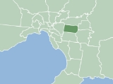
. It has an area of 64 km² (25 sq mi) and has a estimated population of 155,725 people.
Whitehorse was formed in December 1994 by the amalgamation of the former Cities of Box Hill
Box Hill, Victoria
Box Hill is a suburb in Melbourne, Victoria, Australia, 14 km east from Melbourne's central business district. Its Local Government Area is the City of Whitehorse. At the 2006 Census, Box Hill had a population of 8,616....
and Nunawading
Nunawading, Victoria
Nunawading is a suburb in Melbourne, Victoria, Australia, 19 km east from Melbourne's central business district. Its Local Government Area is the City of Whitehorse...
. The name Whitehorse came from the White Horse Inn, a tavern
Tavern
A tavern is a place of business where people gather to drink alcoholic beverages and be served food, and in some cases, where travelers receive lodging....
originally located in the area in the late 19th Century. This name was applied to the major thoroughfare
Thoroughfare
A thoroughfare is a place of transportation intended to connect one location to another. Highways, roads, and trails are examples of thoroughfares used by a variety of general traffic. On land a thoroughfare may refer to anything from a rough trail to multi-lane highway with grade separated...
, Whitehorse Road, which runs through the municipality
Municipality
A municipality is essentially an urban administrative division having corporate status and usually powers of self-government. It can also be used to mean the governing body of a municipality. A municipality is a general-purpose administrative subdivision, as opposed to a special-purpose district...
today.
In the original proposals for council amalgamations in Melbourne, Whitehorse was a suggested name for an area comprising the City of Box Hill
City of Box Hill
The City of Box Hill was a Local Government Area located about east of Melbourne, the state capital of Victoria, Australia. The city covered an area of , and existed from 1927 until 1994.-History:...
, with the addition of residents east of Union Road (part of the old City of Camberwell
City of Camberwell
The City of Camberwell was a Local Government Area located about east of Melbourne, the state capital of Victoria, Australia. The city covered an area of , and existed from 1914 until 1994.-History:...
). The affected residents were unhappy, believing an alignment with Box Hill would lower the value of their properties. A second proposal featured the current boundaries of Whitehorse. The City of Nunawading
City of Nunawading
The City of Nunawading was a Local Government Area located about east of Melbourne, the state capital of Victoria, Australia. The city covered an area of , and existed from 1925 until 1994.-History:...
proposed the name "City of Koornung", claiming it was more appropriate as both cities shared the Koonung Creek
Koonung Creek
Koonung Creek is a small tributary of the Yarra River in Melbourne's east. The creek originates in Nunawading near Springvale Road, and flows to join the Yarra at the border between Ivanhoe East, Bulleen and Balwyn North. The place the two waterways meet forms the borders between these suburbs...
, but unfortunately they failed to note they had spelled Koonung incorrectly in their proposal. Another suggestion was "City of Deakin", as the region of Whitehorse contains both the Federal electorate
Electoral district
An electoral district is a distinct territorial subdivision for holding a separate election for one or more seats in a legislative body...
of Deakin
Division of Deakin
The Division of Deakin is anAustralian Electoral Division in Victoria. It is named for Alfred Deakin, three times Prime Minister of Australia. The division was created in 1937, initially as a rural seat, but since 1949 it has been located in the eastern suburbs of Melbourne, today taking in...
, and the Melbourne campus of Deakin University
Deakin University
Deakin University is an Australian public university with nearly 40,000 higher education students in 2010. It receives more than A$600 million in operating revenue annually, and controls more than A$1.3 billion in assets. It received more than A$35 million in research income in 2009 and had 835...
in Burwood
Burwood, Victoria
Burwood is a suburb in Melbourne, Victoria, Australia, 17 km east from Melbourne's central business district. Its Local Government Area is largely the City of Whitehorse but includes the City of Monash in its south west corner. At the 2006 Census, Burwood had a population of 11,886.-History:The...
.
Suburbs of Whitehorse
- BlackburnBlackburn, VictoriaBlackburn is a suburb in Melbourne, Victoria, Australia, 17 km east from Melbourne's central business district. Its Local Government Area is the City of Whitehorse. At the 2006 Census, Blackburn had a population of 11,958....
- Blackburn NorthBlackburn North, VictoriaBlackburn North is a suburb in Melbourne, Victoria, Australia, 17 km east from Melbourne's central business district. Its Local Government Area is the City of Whitehorse. At the 2006 Census, Blackburn North had a population of 6816....
- Blackburn SouthBlackburn South, VictoriaBlackburn South is a suburb in Melbourne, Victoria, Australia, 16 km east from Melbourne's central business district. Its Local Government Area is the City of Whitehorse...
- Box HillBox Hill, VictoriaBox Hill is a suburb in Melbourne, Victoria, Australia, 14 km east from Melbourne's central business district. Its Local Government Area is the City of Whitehorse. At the 2006 Census, Box Hill had a population of 8,616....
- Box Hill NorthBox Hill North, VictoriaBox Hill North is a suburb in Melbourne, Victoria, Australia, 14 km east from Melbourne's central business district. Its Local Government Area is the City of Whitehorse. At the 2006 Census, Box Hill North had a population of 10,649....
- Box Hill SouthBox Hill South, VictoriaBox Hill South is a suburb in Melbourne, Victoria, Australia, 14 km east from Melbourne's central business district. Its Local Government Area is the City of Whitehorse...
- BurwoodBurwood, VictoriaBurwood is a suburb in Melbourne, Victoria, Australia, 17 km east from Melbourne's central business district. Its Local Government Area is largely the City of Whitehorse but includes the City of Monash in its south west corner. At the 2006 Census, Burwood had a population of 11,886.-History:The...
(Shared with City of MonashCity of MonashThe City of Monash is a Local Government Area in Melbourne, Victoria, Australia. It is located in the southeastern suburbs of Melbourne and has an area of 81.0 square kilometres and has a estimated population of 176,069 people...
) - Burwood EastBurwood East, VictoriaBurwood East is a suburb in Melbourne, Victoria, Australia, located 17 km east of Melbourne's central business district. Its Local Government Area is the City of Whitehorse. The suburb is bounded by Springvale Road to the east, by Middleborough Road to the west, by Eley Road and Hawthorn Road...
- Forest HillForest Hill, VictoriaForest Hill is a suburb in Melbourne, Victoria, Australia, 18 km east from Melbourne's central business district. Its Local Government Area is the City of Whitehorse. At the 2006 Census, Forest Hill had a population of 9315.-History:...
- MitchamMitcham, VictoriaMitcham is a suburb in Melbourne, Victoria, Australia, 20 km east from Melbourne's central business district. Its Local Government Area is the City of Whitehorse. At the 2006 Census, Mitcham had a population of 14,211.-History:...
- Mont AlbertMont Albert, VictoriaMont Albert is a suburb in Melbourne, Victoria, Australia, 12 km east from Melbourne's central business district. Its Local Government Area are the Cities of Whitehorse and Boroondara. At the 2006 Census, Mont Albert had a population of 4419....
(Shared with City of BoroondaraCity of BoroondaraThe City of Boroondara is a Local Government Area in Victoria, Australia. It is located in the eastern suburbs of Melbourne.This area was originally occupied by the Wurundjeri, Indigenous Australians of the Kulin nation....
) - Mont Albert NorthMont Albert North, VictoriaMont Albert North is a suburb in Melbourne, Victoria, Australia, 13 km east from Melbourne's central business district. Its Local Government Area is the City of Whitehorse. At the 2006 Census, Mont Albert North had a population of 5008....
- NunawadingNunawading, VictoriaNunawading is a suburb in Melbourne, Victoria, Australia, 19 km east from Melbourne's central business district. Its Local Government Area is the City of Whitehorse...
- Surrey HillsSurrey Hills, VictoriaSurrey Hills is a suburb in Melbourne, Victoria, Australia, 12 km east from Melbourne's central business district. Its Local Government Area lies within the cities of Boroondara and Whitehorse...
(eastern fringe only) - VermontVermont, VictoriaVermont is a suburb in Melbourne, Victoria, Australia, 21 km east from Melbourne's central business district. Its Local Government Area is primarily within the City of Whitehorse whilst the north east portion is within the City of Maroondah...
- Vermont SouthVermont South, VictoriaVermont South is a suburb in Melbourne, Victoria, Australia, 20 km east from Melbourne's central business district. Its Local Government Area is the City of Whitehorse. At the 2006 Census, Vermont South had a population of 11,485....
Other locally recognised names for regions in the city include:
- Bellbird
- BennettswoodBennettswood, VictoriaBennettswood is a locality located in Burwood, in Melbourne's eastern suburbs....
- HeatherdaleHeatherdale, VictoriaHeatherdale is a locality located in Mitcham, in Melbourne's eastern suburbs, centred around the Heatherdale railway station, on the Lilydale line.-References:...
- Houston
- LaburnumLaburnum, VictoriaLaburnum refers to a small area in the 'Bellbird' area of the suburb of Blackburn, Victoria, Australia. It covers the area bordered by Middleborough and Blackburn Roads, Gardiners Creek and the Belgrave/Lilydale railway line. It is a heavily treed area noted for its Laburnum bushes...
- KerrimuirKerrimuir, VictoriaKerrimuir is a locality within the suburb of Box Hill North in Melbourne, Victoria, Australia. It is in the City of Whitehorse in Melbourne's eastern suburbs, approximately 15 kilometres from the CBD.The area is mostly referred to as Box Hill North...
- Tally HoBurwood East, VictoriaBurwood East is a suburb in Melbourne, Victoria, Australia, located 17 km east of Melbourne's central business district. Its Local Government Area is the City of Whitehorse. The suburb is bounded by Springvale Road to the east, by Middleborough Road to the west, by Eley Road and Hawthorn Road...
- Wattle Park
Former names within the region:
- Air Hill - now MitchamMitcham, VictoriaMitcham is a suburb in Melbourne, Victoria, Australia, 20 km east from Melbourne's central business district. Its Local Government Area is the City of Whitehorse. At the 2006 Census, Mitcham had a population of 14,211.-History:...
- Ballyshannassy - small township located in present BurwoodBurwood, VictoriaBurwood is a suburb in Melbourne, Victoria, Australia, 17 km east from Melbourne's central business district. Its Local Government Area is largely the City of Whitehorse but includes the City of Monash in its south west corner. At the 2006 Census, Burwood had a population of 11,886.-History:The...
, 1860s - Beverley Hills - attached to Blackburn NorthBlackburn North, VictoriaBlackburn North is a suburb in Melbourne, Victoria, Australia, 17 km east from Melbourne's central business district. Its Local Government Area is the City of Whitehorse. At the 2006 Census, Blackburn North had a population of 6816....
, late 1960s-early 1970s - Emery's Hill - now MitchamMitcham, VictoriaMitcham is a suburb in Melbourne, Victoria, Australia, 20 km east from Melbourne's central business district. Its Local Government Area is the City of Whitehorse. At the 2006 Census, Mitcham had a population of 14,211.-History:...
- L.L. Vale - name for VermontVermont, VictoriaVermont is a suburb in Melbourne, Victoria, Australia, 21 km east from Melbourne's central business district. Its Local Government Area is primarily within the City of Whitehorse whilst the north east portion is within the City of Maroondah...
used up until c.1885 - Norwood - second name of Ballyshannassy, renamed BurwoodBurwood, VictoriaBurwood is a suburb in Melbourne, Victoria, Australia, 17 km east from Melbourne's central business district. Its Local Government Area is largely the City of Whitehorse but includes the City of Monash in its south west corner. At the 2006 Census, Burwood had a population of 11,886.-History:The...
in 1879 - Mount Pleasant - 1860s name, now eastern area of Forest HillForest Hill, VictoriaForest Hill is a suburb in Melbourne, Victoria, Australia, 18 km east from Melbourne's central business district. Its Local Government Area is the City of Whitehorse. At the 2006 Census, Forest Hill had a population of 9315.-History:...
- Scotchman's Hill - 1860s name, now Forest HillForest Hill, VictoriaForest Hill is a suburb in Melbourne, Victoria, Australia, 18 km east from Melbourne's central business district. Its Local Government Area is the City of Whitehorse. At the 2006 Census, Forest Hill had a population of 9315.-History:...
- Tally Ho - incorporated into Burwood EastBurwood East, VictoriaBurwood East is a suburb in Melbourne, Victoria, Australia, located 17 km east of Melbourne's central business district. Its Local Government Area is the City of Whitehorse. The suburb is bounded by Springvale Road to the east, by Middleborough Road to the west, by Eley Road and Hawthorn Road...
during the 1960s - Tunstall - renamed NunawadingNunawading, VictoriaNunawading is a suburb in Melbourne, Victoria, Australia, 19 km east from Melbourne's central business district. Its Local Government Area is the City of Whitehorse...
in 1945 The city was named after a white horse that was shot in the head by aboriginals
Major Thoroughfares
- Blackburn Road

- Boronia Road

- Burwood Highway

- Canterbury Road

- Elgar Road
- Eastern Freeway

- Highbury Road
- Maroondah HighwayMaroondah HighwayMaroondah Highway , is a major east-west thoroughfare in the eastern suburbs of Melbourne and a highway servicing the lower alpine region Victoria, Australia.-History:...
(Whitehorse Road)
- Middleborough Road

- Mitcham Road
- Riversdale Road

- Springvale Road

- Station Street

- Surrey Road
- Warrigal Road

Sister city
On 12 May 1971, The City of Box HillBox Hill, Victoria
Box Hill is a suburb in Melbourne, Victoria, Australia, 14 km east from Melbourne's central business district. Its Local Government Area is the City of Whitehorse. At the 2006 Census, Box Hill had a population of 8,616....
established a sister city relationship with Matsudo, in Chiba
Chiba Prefecture
is a prefecture of Japan located in the Kantō region and the Greater Tokyo Area. Its capital is Chiba City.- History :Chiba Prefecture was established on June 15, 1873 with the merger of Kisarazu Prefecture and Inba Prefecture...
, Japan
Japan
Japan is an island nation in East Asia. Located in the Pacific Ocean, it lies to the east of the Sea of Japan, China, North Korea, South Korea and Russia, stretching from the Sea of Okhotsk in the north to the East China Sea and Taiwan in the south...
. In December 1994, when Box Hill amalgamated
Amalgamation (politics)
A merger or amalgamation in a political or administrative sense is the combination of two or more political or administrative entities such as municipalities , counties, districts, etc. into a single entity. This term is used when the process occurs within a sovereign entity...
with Nunawading
Nunawading, Victoria
Nunawading is a suburb in Melbourne, Victoria, Australia, 19 km east from Melbourne's central business district. Its Local Government Area is the City of Whitehorse...
, the City of Whitehorse re-affirmed its relationship with Matsudo.