
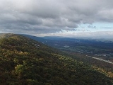
Brush Mountain
Encyclopedia
Brush Mountain is a stratigraphic ridge
in central Pennsylvania
, United States
, running east of the Allegheny Front
and west of Tussey Mountain
. It lies along the southeast side of Little Juniata River
and both sides of the Sinking Run, and is the westernmost ridge in its section of the Ridge-and-valley Appalachians
. The western ridge line separates the Logan Valley from the Sinking Valley.
Brush Mountain lies entirely in Blair County
. It runs from the water gap
formed with Bald Eagle Mountain
by the Little Juniata River
at Tyrone
, south to the Sinking Valley anticline
fold near Altoona
then north to the Canoe Valley syncline
fold, where the ridge becomes Canoe Mountain, a distance of approximately 30 miles (44 km).
No major roads or rivers cross the ridge or run through gaps. Kettle Reservoir collects surface runoff
from a small area in the fold, and the dam was made by filling in a small ravine. Kettle Road, a secondary road, also runs through the ravine near the dam to the Sinking Valley. A major power transmission line crosses the ridge twice, midway between the folds.
The Brush Mountain Ridge is popular with soaring birds and glider
pilots ridge soaring along its slopes. This ridge is part of a chain of ridges that stretch south to Tennessee
. The fold at the south end of Brush Mountain forms a gap in the chain, with the continuation of the ridge line 10 km south on Dunning Mountain.
. Bald Eagle Mountain
, and neighboring Tussey Mountain
ridge, are Paleozoic
rock formations, consisting of older Ordovicial
Bald Eagle Formation
Sandstone
and Juniata Formation
Shale
, and newer Silurian
Tuscarora Formation
Quartzite
that were folded up during the Appalachian orogeny then eroded down to their present form.
The Tuscarora Quartzite is more erosion resistant than Bald Eagle Sandstone, and both are more durable than the Juniata Shale sandwiched in-between. Softer rock layers on either side of these eroded, leaving a double ridge line. On the north end of the mountain, the rock layers are tipped near vertical, and the mountain has the same double crested ridge shape as the Bald Eagle ridge extending to the north, with the crests near the center of the harder rock layers. A little further south, there are several fault lines running across the ridge, and the rock layers then slope down to the west. This leaves the Tuscarora formation more parallel to the steeper western slope, with the crest marking the dividing line between the layers. The tougher rock also protected the slope from erosion, leaving a higher southern ridge line.
The tilted aspect of the rock layers leaves the Juniata formation more perpendicular to the upper portion of the shallower opposite slope, below the steep crest. The Bald Eagle formation below holds back the eroding rock, creating a shelf above a steeper lower slope running down to the Sinking Valley. The drainage in the shelf area cut a series of small ravines, leaving terraces between them. The terraces wrap around the inside of the anticline
fold around the Sinking Valley, and then around the outside of the reverse fold on Canoe Mountain.
 See also: Geology of Bald Eagle Mountain
Ridge
A ridge is a geological feature consisting of a chain of mountains or hills that form a continuous elevated crest for some distance. Ridges are usually termed hills or mountains as well, depending on size. There are several main types of ridges:...
in central Pennsylvania
Pennsylvania
The Commonwealth of Pennsylvania is a U.S. state that is located in the Northeastern and Mid-Atlantic regions of the United States. The state borders Delaware and Maryland to the south, West Virginia to the southwest, Ohio to the west, New York and Ontario, Canada, to the north, and New Jersey to...
, United States
United States
The United States of America is a federal constitutional republic comprising fifty states and a federal district...
, running east of the Allegheny Front
Allegheny Front
The Allegheny Front is the major southeast- or east-facing escarpment in the Allegheny Mountains in southern Pennsylvania, western Maryland, and eastern West Virginia, USA. The Allegheny Front delineates the Ridge-and-Valley Appalachians to its east from the Appalachian Plateau to its west...
and west of Tussey Mountain
Tussey Mountain
]Tussey Mountain is a stratigraphic ridge in central Pennsylvania, United States, trending east of the Bald Eagle, Brush, Dunning and Evitts Mountain ridges...
. It lies along the southeast side of Little Juniata River
Little Juniata River
]The Little Juniata River, sometimes called the "Little J," is a river in central Pennsylvania. It is a tributary of the Juniata River in the Susquehanna River watershed. It is formed at Altoona by the confluence of several short streams...
and both sides of the Sinking Run, and is the westernmost ridge in its section of the Ridge-and-valley Appalachians
Ridge-and-valley Appalachians
The Ridge-and-Valley Appalachians, also called the Ridge and Valley Province or the Valley and Ridge Appalachians, are a physiographic province of the larger Appalachian division and are also a belt within the Appalachian Mountains extending from southeastern New York through northwestern New...
. The western ridge line separates the Logan Valley from the Sinking Valley.
Brush Mountain lies entirely in Blair County
Blair County, Pennsylvania
-Significant Topographic Features:*Brush Mountain*Logan Valley*Morrison Cove*Tussey Mountain-Demographics:As of the census of 2000, there were 129,144 people, 51,518 households, and 34,877 families residing in the county. The population density was 246 people per square mile . There were 55,061...
. It runs from the water gap
Water gap
A water gap is an opening or notch which flowing water has carved through a mountain range. Water gaps often offer a practical route for road and rail transport to cross mountain ridges.- Geology :...
formed with Bald Eagle Mountain
Bald Eagle Mountain
Bald Eagle Mountain, once known locally as Muncy Mountain, is a stratigraphic ridge in central Pennsylvania, United States, running east of the Allegheny Front and northwest of Mount Nittany. It lies along the southeast side of Bald Eagle Creek, and south of the West Branch Susquehanna River, and...
by the Little Juniata River
Little Juniata River
]The Little Juniata River, sometimes called the "Little J," is a river in central Pennsylvania. It is a tributary of the Juniata River in the Susquehanna River watershed. It is formed at Altoona by the confluence of several short streams...
at Tyrone
Tyrone, Pennsylvania
Tyrone is a borough in Blair County, Pennsylvania, northeast of Altoona, on the Little Juniata River. Tyrone was of considerable commercial importance in the twentieth century. It was an outlet for the Clearfield coal fields, and it was noted for the manufacture of paper products. There were...
, south to the Sinking Valley anticline
Anticline
In structural geology, an anticline is a fold that is convex up and has its oldest beds at its core. The term is not to be confused with antiform, which is a purely descriptive term for any fold that is convex up. Therefore if age relationships In structural geology, an anticline is a fold that is...
fold near Altoona
Altoona, Pennsylvania
-History:A major railroad town, Altoona was founded by the Pennsylvania Railroad in 1849 as the site for a shop complex. Altoona was incorporated as a borough on February 6, 1854, and as a city under legislation approved on April 3, 1867, and February 8, 1868...
then north to the Canoe Valley syncline
Syncline
In structural geology, a syncline is a fold, with younger layers closer to the center of the structure. A synclinorium is a large syncline with superimposed smaller folds. Synclines are typically a downward fold, termed a synformal syncline In structural geology, a syncline is a fold, with younger...
fold, where the ridge becomes Canoe Mountain, a distance of approximately 30 miles (44 km).
No major roads or rivers cross the ridge or run through gaps. Kettle Reservoir collects surface runoff
Surface runoff
Surface runoff is the water flow that occurs when soil is infiltrated to full capacity and excess water from rain, meltwater, or other sources flows over the land. This is a major component of the water cycle. Runoff that occurs on surfaces before reaching a channel is also called a nonpoint source...
from a small area in the fold, and the dam was made by filling in a small ravine. Kettle Road, a secondary road, also runs through the ravine near the dam to the Sinking Valley. A major power transmission line crosses the ridge twice, midway between the folds.
The Brush Mountain Ridge is popular with soaring birds and glider
Glider (sailplane)
A glider or sailplane is a type of glider aircraft used in the sport of gliding. Some gliders, known as motor gliders are used for gliding and soaring as well, but have engines which can, in some cases, be used for take-off or for extending a flight...
pilots ridge soaring along its slopes. This ridge is part of a chain of ridges that stretch south to Tennessee
Tennessee
Tennessee is a U.S. state located in the Southeastern United States. It has a population of 6,346,105, making it the nation's 17th-largest state by population, and covers , making it the 36th-largest by total land area...
. The fold at the south end of Brush Mountain forms a gap in the chain, with the continuation of the ridge line 10 km south on Dunning Mountain.
Geology
Brush Mountain is in the western part of the Ridge and Valley province of the Appalachian MountainsAppalachian Mountains
The Appalachian Mountains #Whether the stressed vowel is or ,#Whether the "ch" is pronounced as a fricative or an affricate , and#Whether the final vowel is the monophthong or the diphthong .), often called the Appalachians, are a system of mountains in eastern North America. The Appalachians...
. Bald Eagle Mountain
Bald Eagle Mountain
Bald Eagle Mountain, once known locally as Muncy Mountain, is a stratigraphic ridge in central Pennsylvania, United States, running east of the Allegheny Front and northwest of Mount Nittany. It lies along the southeast side of Bald Eagle Creek, and south of the West Branch Susquehanna River, and...
, and neighboring Tussey Mountain
Tussey Mountain
]Tussey Mountain is a stratigraphic ridge in central Pennsylvania, United States, trending east of the Bald Eagle, Brush, Dunning and Evitts Mountain ridges...
ridge, are Paleozoic
Paleozoic
The Paleozoic era is the earliest of three geologic eras of the Phanerozoic eon, spanning from roughly...
rock formations, consisting of older Ordovicial
Ordovician
The Ordovician is a geologic period and system, the second of six of the Paleozoic Era, and covers the time between 488.3±1.7 to 443.7±1.5 million years ago . It follows the Cambrian Period and is followed by the Silurian Period...
Bald Eagle Formation
Bald Eagle Formation
The Ordovician Bald Eagle Formation is a mapped bedrock unit in central Pennsylvania, USA. It is a ridge-forming unit in the Appalachian Mountains.-Description:...
Sandstone
Sandstone
Sandstone is a sedimentary rock composed mainly of sand-sized minerals or rock grains.Most sandstone is composed of quartz and/or feldspar because these are the most common minerals in the Earth's crust. Like sand, sandstone may be any colour, but the most common colours are tan, brown, yellow,...
and Juniata Formation
Juniata Formation
The Ordovician Juniata Formation is a mapped bedrock unit in Pennsylvania and Maryland. It is a relative slope-former occurring between the two prominent ridge-forming sandstone units: the Tuscarora Formation and the Bald Eagle Formation in the Appalachian Mountains.-Description:The Juniata is...
Shale
Shale
Shale is a fine-grained, clastic sedimentary rock composed of mud that is a mix of flakes of clay minerals and tiny fragments of other minerals, especially quartz and calcite. The ratio of clay to other minerals is variable. Shale is characterized by breaks along thin laminae or parallel layering...
, and newer Silurian
Silurian
The Silurian is a geologic period and system that extends from the end of the Ordovician Period, about 443.7 ± 1.5 Mya , to the beginning of the Devonian Period, about 416.0 ± 2.8 Mya . As with other geologic periods, the rock beds that define the period's start and end are well identified, but the...
Tuscarora Formation
Tuscarora Formation
The Silurian Tuscarora Formation — also known as Tuscarora Sandstone or Tuscarora Quartzite — is a mapped bedrock unit in Pennsylvania, Maryland, West Virginia, and Virginia.-Description:...
Quartzite
Quartzite
Quartzite is a hard metamorphic rock which was originally sandstone. Sandstone is converted into quartzite through heating and pressure usually related to tectonic compression within orogenic belts. Pure quartzite is usually white to gray, though quartzites often occur in various shades of pink...
that were folded up during the Appalachian orogeny then eroded down to their present form.
The Tuscarora Quartzite is more erosion resistant than Bald Eagle Sandstone, and both are more durable than the Juniata Shale sandwiched in-between. Softer rock layers on either side of these eroded, leaving a double ridge line. On the north end of the mountain, the rock layers are tipped near vertical, and the mountain has the same double crested ridge shape as the Bald Eagle ridge extending to the north, with the crests near the center of the harder rock layers. A little further south, there are several fault lines running across the ridge, and the rock layers then slope down to the west. This leaves the Tuscarora formation more parallel to the steeper western slope, with the crest marking the dividing line between the layers. The tougher rock also protected the slope from erosion, leaving a higher southern ridge line.
The tilted aspect of the rock layers leaves the Juniata formation more perpendicular to the upper portion of the shallower opposite slope, below the steep crest. The Bald Eagle formation below holds back the eroding rock, creating a shelf above a steeper lower slope running down to the Sinking Valley. The drainage in the shelf area cut a series of small ravines, leaving terraces between them. The terraces wrap around the inside of the anticline
Anticline
In structural geology, an anticline is a fold that is convex up and has its oldest beds at its core. The term is not to be confused with antiform, which is a purely descriptive term for any fold that is convex up. Therefore if age relationships In structural geology, an anticline is a fold that is...
fold around the Sinking Valley, and then around the outside of the reverse fold on Canoe Mountain.