
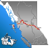
British Columbia provincial highway 16
Encyclopedia
Highway 16 is the British Columbia
, Canada
, section of the Yellowhead Highway
. The highway closely follows the path of the northern B.C. alignment of the Canadian National Railway
. The number "16" was first given to the highway in 1942, and originally, the route that the highway took was more to the north of today's highway, and it was not as long as it is now. Highway 16 originally ran from New Hazelton
east to an obscure location known as Aleza Lake
. In 1947, Highway 16's western end was moved from New Hazelton to the coastal city of Prince Rupert
, and in 1953, the highway was extended all the way east into Yellowhead Pass
. Highway 16's alignment on the Haida Gwaii was commissioned in 1984, with BC Ferries
beginning service along Highway 16 to the Haida Gwaii the following year.
, on the northern coast of Graham Island
. Proceeding south, the highway goes 38 km (24 mi) to the inlet town of Port Clements
. Winding its way along the boundary of Naikoon Provincial Park
, Highway 16 goes south for 27 km (17 mi) before reaching the community of Tlell
. 36 km (22 mi) south of Tlell, Highway 16 reaches Skidegate
, where its Haida Gwaii section terminates.
for 172 km (107 mi) due northeast to its landing at Prince Rupert.
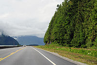 From Prince Rupert, Highway 16 begins its winding route east through the Coast Mountain
Ranges. Following the Skeena River
, the highway travels for 151 km (94 mi) to the city of Terrace
. Highway 37 merges onto Highway 16 in Terrace, and the two highways share a common alignment for 91 km (57 mi) northeast to the Kitwanga
junction, where Highway 37 diverges north. Another 43 km (27 mi) northeast, Highway 16 reaches New Hazelton, where it then veers southeast along the Bulkley River
. 68 km (42 mi) later, the highway reaches the town of Smithers
, proceeding southeast another 64 km (40 mi) to the village of Houston
.
At Houston, Highway 16 begins a parallel course along the little Bulkley River
, proceeding 81 km (50 mi) east to its junction with Highway 35 at Burns Lake
. 128 km (80 mi) east, after passing through the hamlet of Fraser Lake
, Highway 16 reaches its junction with Highway 27 in the town of Vanderhoof
. 97 km (60 mi) east of Vanderhoof, Highway 16 reaches its B.C. midpoint as it enters the city of Prince George
at its junction with Highway 97. Highway 16 leaves Prince George after coursing through the city for 9 km (6 mi) .
120 km (75 mi) east of Prince George, Highway 16 reaches the community of Dome Creek
, where it converges with the Fraser River
and turns southeast. It follows the Fraser River upstream for 82 km (51 mi) to McBride
, then continues upstream for another 64 km (40 mi) to its junction with Highway 5 at Tête Jaune Cache
. 14 km (9 mi) east of Tête Jaune Cache, Highway 16 enters Mount Robson Provincial Park
, coursing through the park for 63 km (39 mi) to the boundary between British Columbia and Alberta
within Yellowhead Pass.
Families of the victims are urging that something should be done to eliminate hitchhiking as the main mode of transportation. "They're almost like caught in a Catch-22, right? What do they do?" a former police volunteer said. "Some come from impoverished families so they can't afford even the cost of a vehicle." In March 2006, nonprofit organizations established a list of 33 recommendations for increasing the overall safety of the community. Their list included a shuttle bus system, emergency telephone booths on parts of the road without cellular service, and programs to educate parents to be more attentive to their children’s travel plans. So far, progress has been made on about half of the recommendations, funded partly by a $52,000 government contribution.
In addition, spurred on by native leaders, the Royal Canadian Mounted Police is officially investigating the unsolved murder or disappearance of nine women between the ages of 14 and 25 since 1974, most of whom were hitchhiking along the highway.
The idea that the murders were all caused by one serial killer is unlikely, yet possible considering all the similarities between the victims including their ethnicity. A former police officer, has begun his own investigation and has attempted to retrace the last steps of the victims. "The terrain is difficult; the bodies could be dumped anywhere," he says. "But that's no excuse for not finding out who is behind these murders.” The police have gathered enough information to declare that there have been at least eight victims, all of which have similar M.O.s: Ramona Wilson, who left home with the intent to meet a friend; Roxanne Thiara, whose body was found in Burns Lake; Delphine Nikal, who was last seen hitchhiking home; Alisha Germaine, a young girl who had just left a holiday dinner and was later found stabbed to death; Lana Derrick, last seen at a service station; Nicole Hoar and Tamara Chipman, who were also hitchhiking home; and Aielah Auger, who was reportedly seen getting into a black van before her body was discovered off the road. All of the young women were last spotted traveling along or near the highway.
In 2009 police converged on a property in Isle Pierre, in rural Prince George to search for remains of Nicole Hoar, a young tree planter who went missing on Highway 16, on June 21, 2002. The property was once owned by Leland Vincent Switzer who is currently serving a prison sentence for the 2nd degree murder of his brother. The RCMP also searched the property for the other missing women from the Highway of Tears, however no further actions followed the investigation.
One of the victims found alongside the highway, 16-year-old Ramona Wilson, was a subject of a 2006 documentary film
by Métis
filmmaker Christine Welsh
, entitled Finding Dawn
.
In February 2006, private investigator Ray Michalko of Valley Pacific Investigations, an ex-member of the RCMP, ran an ad in a northern community newspaper asking for anyone with information regarding the Highway of Tears to call him. The newspaper ad generated a number of calls and five years later, in 2011 Michalko is still conducting his Tears investigation, and continues to believe that there is more than one killer responsible for the Highway 16 missing and murdered women.
Michalko, who said that when he became a cop, he would’ve done it for room and board, claims that his ability to blend in, being comfortable working alone and independently and his ability to gain the trust of a wide range of people have all helped in his investigation. See ref http://www.northword.ca/april-2007/private-investigator-moved-by-highway-of-tears
British Columbia
British Columbia is the westernmost of Canada's provinces and is known for its natural beauty, as reflected in its Latin motto, Splendor sine occasu . Its name was chosen by Queen Victoria in 1858...
, Canada
Canada
Canada is a North American country consisting of ten provinces and three territories. Located in the northern part of the continent, it extends from the Atlantic Ocean in the east to the Pacific Ocean in the west, and northward into the Arctic Ocean...
, section of the Yellowhead Highway
Yellowhead Highway
The Yellowhead Highway is a major east-west highway connecting the four western Canadian provinces of British Columbia, Alberta, Saskatchewan, and Manitoba. Although part of the Trans-Canada Highway system, the highway should not be confused with the more southerly, originally-designated...
. The highway closely follows the path of the northern B.C. alignment of the Canadian National Railway
Canadian National Railway
The Canadian National Railway Company is a Canadian Class I railway headquartered in Montreal, Quebec. CN's slogan is "North America's Railroad"....
. The number "16" was first given to the highway in 1942, and originally, the route that the highway took was more to the north of today's highway, and it was not as long as it is now. Highway 16 originally ran from New Hazelton
New Hazelton, British Columbia
New Hazelton is a community on Highway 16 in northwest British Columbia, Canada. It is situated east of Terrace and west of Smithers and in 2006 had a population of 627 people...
east to an obscure location known as Aleza Lake
Aleza Lake, British Columbia
Aleza Lake is a community located on the southwest end of Hansard Lake, west of Upper Fraser, British Columbia. The Grand Trunk Pacific Railway built a station here in 1914. The Aleza Lake Post Office opened 1 June 1915 with J.A. Davidson as postmaster; it closed 30 September 1970.Aleza Lake was...
. In 1947, Highway 16's western end was moved from New Hazelton to the coastal city of Prince Rupert
Prince Rupert, British Columbia
Prince Rupert is a port city in the province of British Columbia, Canada. It is the land, air, and water transportation hub of British Columbia's North Coast, and home to some 12,815 people .-History:...
, and in 1953, the highway was extended all the way east into Yellowhead Pass
Yellowhead Pass
The Yellowhead Pass is a mountain pass across the Continental Divide of the Canadian Rockies. It is located on the border between the Canadian provinces of Alberta and British Columbia, and lies within Jasper National Park and Mount Robson Provincial Park....
. Highway 16's alignment on the Haida Gwaii was commissioned in 1984, with BC Ferries
BC Ferries
British Columbia Ferry Services Inc. or BC Ferries is a de facto Crown Corporation that provides all major passenger and vehicle ferry services for coastal and island communities in the Canadian province of British Columbia...
beginning service along Highway 16 to the Haida Gwaii the following year.
Haida Gwaii Highway
The 1,347 km (837 mi)-long B.C. segment of Highway 16 begins in the west in the village of MassetMasset, British Columbia
Masset , formerly Massett, is a village in Haida Gwaii in British Columbia, Canada. It is located on the northern coast of Graham Island, the largest island in the archipelago, and is approximately west of mainland British Columbia. It is the western terminus of the Yellowhead Highway...
, on the northern coast of Graham Island
Graham Island
Graham Island is the largest island in the Haida Gwaii archipelago , lying off the coast of British Columbia, Canada. It is separated only by a narrow channel from the other principal island of the group, Moresby Island Graham Island is the largest island in the Haida Gwaii archipelago (formerly...
. Proceeding south, the highway goes 38 km (24 mi) to the inlet town of Port Clements
Port Clements, British Columbia
Port Clements is a village situated at the east end of Masset Inlet in Haida Gwaii off the coast of the Province of British Columbia in Canada. Founded by Eli Tingley in 1907, it was once known under the name Queenstown, but renamed to Port Clements in 1914 after Herb S...
. Winding its way along the boundary of Naikoon Provincial Park
Naikoon Provincial Park
Naikoon Provincial Park is a provincial park on Graham Island in the Haida Gwaii archipelago, British Columbia, Canada. It is the ancestral home of the Gwak'rala'chala people, one of the many tribes that form the native group Haida...
, Highway 16 goes south for 27 km (17 mi) before reaching the community of Tlell
Tlell, British Columbia
Tlell is a small, unincorporated place on the east coast of Graham Island, which is part of Haida Gwaii in British Columbia, Canada.-History:...
. 36 km (22 mi) south of Tlell, Highway 16 reaches Skidegate
Skidegate
Skidegate is a Haida community in Haida Gwaii in British Columbia, Canada. It is located on the southeast coast of Graham Island, the largest island in the archipelago, and is approximately west of mainland British Columbia across Hecate Strait...
, where its Haida Gwaii section terminates.
Yellowhead Trans-Canada Highway
BC Ferries then takes Highway 16 across the Hecate StraitHecate Strait
Hecate Strait is a wide but shallow strait between the Haida Gwaii and the mainland of British Columbia, Canada. It merges with Queen Charlotte Sound to the south and Dixon Entrance to the north...
for 172 km (107 mi) due northeast to its landing at Prince Rupert.
Coast Mountains
The Coast Mountains are a major mountain range, in the Pacific Coast Ranges, of western North America, extending from southwestern Yukon through the Alaska Panhandle and virtually all of the Coast of British Columbia. They are so-named because of their proximity to the sea coast, and are often...
Ranges. Following the Skeena River
Skeena River
The Skeena River is the second longest river entirely within British Columbia, Canada . The Skeena is an important transportation artery, particularly for the Tsimshian and the Gitxsan - whose names mean "inside the Skeena River" and "people of the Skeena River" respectively, and also during the...
, the highway travels for 151 km (94 mi) to the city of Terrace
Terrace, British Columbia
Terrace is a city on the Skeena River in British Columbia, Canada. The Kitselas people, a tribe of the Tsimshian Nation, have lived in the Terrace area for thousands of years. The community population fell between 2001 and 2006 from 12,109 with a regional population of 19,980 to 11,320 and...
. Highway 37 merges onto Highway 16 in Terrace, and the two highways share a common alignment for 91 km (57 mi) northeast to the Kitwanga
Kitwanga, British Columbia
Kitwanga or Gitwangax is located where the Kitwanga River runs into the Skeena River in British Columbia. A long-standing village before Contact, the village is within Gitwangak Indian Reserve No...
junction, where Highway 37 diverges north. Another 43 km (27 mi) northeast, Highway 16 reaches New Hazelton, where it then veers southeast along the Bulkley River
Bulkley River
The Bulkley River in British Columbia is a major tributary of the Skeena River. The Bulkley is 257 km long with a drainage basin covering 12,400 km²....
. 68 km (42 mi) later, the highway reaches the town of Smithers
Smithers, British Columbia
Smithers is a town located in northwestern British Columbia, Canada, approximately halfway between Prince George and Prince Rupert. Smithers is located in the Regional District of Bulkley-Nechako....
, proceeding southeast another 64 km (40 mi) to the village of Houston
Houston, British Columbia
Houston is a forestry, mining and tourism town in the Bulkley Valley of the Northern Interior of British Columbia, Canada. Its urban population is approximately 3600 people, with approximately 2000 in the surrounding rural area. It is known as the "Steelhead Capital" and it has the world's largest...
.
At Houston, Highway 16 begins a parallel course along the little Bulkley River
Bulkley River
The Bulkley River in British Columbia is a major tributary of the Skeena River. The Bulkley is 257 km long with a drainage basin covering 12,400 km²....
, proceeding 81 km (50 mi) east to its junction with Highway 35 at Burns Lake
Burns Lake, British Columbia
thumb|309px|right|Burns Lake's welcome signBurns Lake is a rural village in the North-Central Interior of British Columbia, Canada, incorporated in 1923...
. 128 km (80 mi) east, after passing through the hamlet of Fraser Lake
Fraser Lake, British Columbia
Fraser Lake is a village in northern British Columbia, Canada. It is located on the southwest side of Fraser Lake between Burns Lake and Vanderhoof alongside the Yellowhead Highway....
, Highway 16 reaches its junction with Highway 27 in the town of Vanderhoof
Vanderhoof, British Columbia
-External links:**...
. 97 km (60 mi) east of Vanderhoof, Highway 16 reaches its B.C. midpoint as it enters the city of Prince George
Prince George, British Columbia
Prince George, with a population of 71,030 , is the largest city in northern British Columbia, Canada, and is known as "BC's Northern Capital"...
at its junction with Highway 97. Highway 16 leaves Prince George after coursing through the city for 9 km (6 mi) .
120 km (75 mi) east of Prince George, Highway 16 reaches the community of Dome Creek
Dome Creek, British Columbia
Dome Creek is a community located between Prince George and McBride in central British Columbia. A post office was opened here 1 May 1916, with J.O. Kendall as postmaster. The post office closed 31 January 1936, then re-opened 6 September 1937...
, where it converges with the Fraser River
Fraser River
The Fraser River is the longest river within British Columbia, Canada, rising at Fraser Pass near Mount Robson in the Rocky Mountains and flowing for , into the Strait of Georgia at the city of Vancouver. It is the tenth longest river in Canada...
and turns southeast. It follows the Fraser River upstream for 82 km (51 mi) to McBride
McBride, British Columbia
Situated on the Yellowhead Highway , McBride is a small community in the Robson Valley region of British Columbia, Canada, located southeast of Prince George, west of the Alberta border, and west of Jasper, Alberta....
, then continues upstream for another 64 km (40 mi) to its junction with Highway 5 at Tête Jaune Cache
Tête Jaune Cache, British Columbia
Tête Jaune Cache is an unincorporated rural area and the site of an important abandoned historic town in British Columbia, Canada. Its population is approximately 500. It is located on the Fraser River in the Robson Valley at the intersection of Yellowhead Highways 5 and 16...
. 14 km (9 mi) east of Tête Jaune Cache, Highway 16 enters Mount Robson Provincial Park
Mount Robson Provincial Park
Mount Robson Provincial Park is a large provincial park in the Canadian Rockies with an area of 2,249 km². The park is located entirely within British Columbia, bordering Jasper National Park in Alberta. The B.C. legislature created the park in 1913, the same year as the first ascent of Mount...
, coursing through the park for 63 km (39 mi) to the boundary between British Columbia and Alberta
Alberta
Alberta is a province of Canada. It had an estimated population of 3.7 million in 2010 making it the most populous of Canada's three prairie provinces...
within Yellowhead Pass.
Highway of Tears
A series of unsolved murders and disappearances of young women has earned the route the nickname the "Highway of Tears" along the 800 km (500 mi) section of highway between Prince George and Prince Rupert. It is unknown how many women have been killed or have suspiciously disappeared since 1969, but some estimate the number could be as high as 43. By October 2007, Project E-Pana, an investigation by the RCMP (Royal Canadian Mounted Police) examining the similarities among these murders and disappearances, determined that 18 of them show enough similarities to be linked. These are the unsolved murders and missing-persons files that are collectively called "The Highway of Tears" case.Families of the victims are urging that something should be done to eliminate hitchhiking as the main mode of transportation. "They're almost like caught in a Catch-22, right? What do they do?" a former police volunteer said. "Some come from impoverished families so they can't afford even the cost of a vehicle." In March 2006, nonprofit organizations established a list of 33 recommendations for increasing the overall safety of the community. Their list included a shuttle bus system, emergency telephone booths on parts of the road without cellular service, and programs to educate parents to be more attentive to their children’s travel plans. So far, progress has been made on about half of the recommendations, funded partly by a $52,000 government contribution.
In addition, spurred on by native leaders, the Royal Canadian Mounted Police is officially investigating the unsolved murder or disappearance of nine women between the ages of 14 and 25 since 1974, most of whom were hitchhiking along the highway.
The idea that the murders were all caused by one serial killer is unlikely, yet possible considering all the similarities between the victims including their ethnicity. A former police officer, has begun his own investigation and has attempted to retrace the last steps of the victims. "The terrain is difficult; the bodies could be dumped anywhere," he says. "But that's no excuse for not finding out who is behind these murders.” The police have gathered enough information to declare that there have been at least eight victims, all of which have similar M.O.s: Ramona Wilson, who left home with the intent to meet a friend; Roxanne Thiara, whose body was found in Burns Lake; Delphine Nikal, who was last seen hitchhiking home; Alisha Germaine, a young girl who had just left a holiday dinner and was later found stabbed to death; Lana Derrick, last seen at a service station; Nicole Hoar and Tamara Chipman, who were also hitchhiking home; and Aielah Auger, who was reportedly seen getting into a black van before her body was discovered off the road. All of the young women were last spotted traveling along or near the highway.
In 2009 police converged on a property in Isle Pierre, in rural Prince George to search for remains of Nicole Hoar, a young tree planter who went missing on Highway 16, on June 21, 2002. The property was once owned by Leland Vincent Switzer who is currently serving a prison sentence for the 2nd degree murder of his brother. The RCMP also searched the property for the other missing women from the Highway of Tears, however no further actions followed the investigation.
One of the victims found alongside the highway, 16-year-old Ramona Wilson, was a subject of a 2006 documentary film
Documentary film
Documentary films constitute a broad category of nonfictional motion pictures intended to document some aspect of reality, primarily for the purposes of instruction or maintaining a historical record...
by Métis
Métis people (Canada)
The Métis are one of the Aboriginal peoples in Canada who trace their descent to mixed First Nations parentage. The term was historically a catch-all describing the offspring of any such union, but within generations the culture syncretised into what is today a distinct aboriginal group, with...
filmmaker Christine Welsh
Christine Welsh
Christine Welsh is a Métis filmmaker, feminist and academic in Canada. She has produced, written and directed films for more than 30 years. Welsh's film credits include the 2006 National Film Board of Canada documentary Finding Dawn, about murdered and missing Canadian Aboriginal women...
, entitled Finding Dawn
Finding Dawn
Finding Dawn is a 2006 documentary film by Métis filmmaker Christine Welsh looking into the fate of an estimated 500 Canadian Aboriginal women who have been murdered or have gone missing over the past 30 years....
.
In February 2006, private investigator Ray Michalko of Valley Pacific Investigations, an ex-member of the RCMP, ran an ad in a northern community newspaper asking for anyone with information regarding the Highway of Tears to call him. The newspaper ad generated a number of calls and five years later, in 2011 Michalko is still conducting his Tears investigation, and continues to believe that there is more than one killer responsible for the Highway 16 missing and murdered women.
Michalko, who said that when he became a cop, he would’ve done it for room and board, claims that his ability to blend in, being comfortable working alone and independently and his ability to gain the trust of a wide range of people have all helped in his investigation. See ref http://www.northword.ca/april-2007/private-investigator-moved-by-highway-of-tears