
Bridges of York
Encyclopedia
There are nine bridge
s across the River Ouse
within the city of York
, England
, and sixteen smaller bridges across the narrower River Foss
.
, linked Stonegate (the via praetoria of the Roman fortress) and Micklegate
, and crossed the river approximately where the Guildhall
now is. Its replacement, Ouse Bridge, was a wooden bridge built about 350 metres downstream by the Vikings. It has been rebuilt three times, most recently between 1810 and 1820. The Scarborough Railway Bridge of 1845 was the second bridge to be built, and it was followed by two more road bridges, Lendal Bridge in 1863 and Skeldergate Bridge in 1882. The Millennium Bridge, a footbridge, was added in 2001. There are also Clifton Bridge in the northern suburbs of the city, two modern fly-overs carrying the outer ring road, and the former railway bridge at Naburn
, which is now part of the York-Selby cycle path
.
North to south, the bridges are:
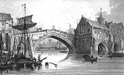
 The original Roman bridge over the Ouse was eventually replaced by a wooden bridge built further downstream by the Vikings. In 1154, it collapsed under the weight of a crowd which had gathered to greet St William of York on his return from exile. It was replaced by a stone bridge. In 1367 the first public toilets in Yorkshire, and likely England, were opened on the bridge. Part of the bridge was swept away by floods in the winter of 1564-5. The repaired bridge of 1565 had a new central arch spanning 81 ft, and was described by Defoe as "...near 70 foot [21 m] in diameter; it is, without exception, the greatest in England, some say it's as large as the Rialto
at Venice
, though I think not." This bridge was dismantled between 1810 and 1818 in order to make way for the New Ouse Bridge, designed by Peter Atkinson the younger, completed in 1821.
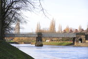 The second bridge across the Ouse was the Scarborough Railway Bridge, built in 1845 to carry the railway line between York and Scarborough (now the Scarborough branch
of the North TransPennine route). Originally it had two tracks with a pedestrian path in between them. In 1875 the track was raised 4 feet (1.2 m) and the footpath moved to the south side, where it remains today.
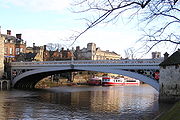 Lendal Bridge was built by Thomas Page
in 1863 and is an iron bridge with Gothic features. It links Station Road with Museum Street and thus York railway station
with York Minster
, and is part of York's Inner Ring Road. At both ends of the bridge stand towers, Barker Tower to the west and Lendal Tower to the east. A rope ferry
previously existed at this location. Lendal Bridge was used in Damon and Debbie
, a 1987 spin-off of soap Brookside
for the scenes where long running charcater Damon Grant
was murdered.
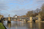 Skeldergate Bridge links the York Castle
area and the old bailey at Baile Hill. It was built as a toll bridge
between 1878 and 1880 (architect: George Gordon Page). A small arch by the former tollhouse at the east end of the bridge was originally designed to open so that tall ships could sail up to the quays on either side of the river between Skeldergate and Ouse Bridges. Skeldergate Bridge was formally declared free of tolls on April 1, 1914.
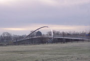 The Millennium Bridge, built to a competition-winning design by Whitby Bird and Partners, was opened on 10 April 2001, having cost £4.2m to build. It spans the River Ouse
to the south of York
, linking Hospital Fields Road and Maple Grove in Fulford
with Butcher Terrace on the South Bank
. The bridge carries a cycle path and a footpath, and is not open to vehicular traffic. It is a key link in the Sustrans
National Cycle Routes 65/66
and will be part of the orbital route for York completed in 2011. The bridge shortened the walk or cycle for students from houses in the South Bank to the University of York
(they previously had to travel via Skeldergate Bridge).
The bridge also acts a meeting place for local people, as it has a waist height shelf spanning the whole structure which facilitates sitting and admiring the view.Increasingly it is used as a circular walk from the city centre taking in the New Walk on the east bank and Terry Avenue and Rowntree Park
on the west bank. While riverside paths regularly flood several times a year the bridge is higher and rarely cut off by floodwaters. Signs on approaches from Fulford Rd /Hospital Fields Rd junction and Butcher Terrace/Bishopthorpe Road warn when it may be impassible without wellies.
Supplies for Fulford Barracks were brought in by river near this location, and the remains of a narrow gauge railway may be seen on the eastern bank of the river a few metres toward the city. There used to be a rope ferry at this location as well.
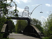 Outside the outer ring-road, the Naburn
bridge used to carry the York-Selby
railway until it was diverted in 1983. It is also known as the "Fisherman Bridge" due to a large metal sculpture
of a fisherman sitting on top which was added in 2000 as part of the York Council "Creative Communities 2000" scheme http://www.solar.york.ac.uk/Naburn_Bridge/naburn_bridge.html.
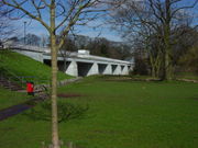 A temporary bridge at Clifton was built by the British Army
in 1961 on the site of an old ferry
crossing in order to handle additional vehicle traffic caused by the wedding of the Duke
and Duchess of Kent at York Minster
. A permanent bridge was opened officially on 28 October 1963. The bridge is built from 4,000 tons of concrete
and 50 tons of reinforced steel
http://archive.thisisyork.co.uk/2001/4/9/304526.html, http://archive.thisisyork.co.uk/2001/9/17/297138.html.
with the Ouse, these are:
Many of these are unobtrusive modern bridges carrying main roads. The following are more notable:
gritstone
arch with baluster
s, links the streets Fossgate and Walmgate. It is believed that the earliest bridge on this site was constructed during the Viking period. The present bridge, designed by Peter Atkinson the younger and erected in 1811-12, replaced a wooden bridge. The bridge was once the site of a fish market
.
and its cooling tower
, both now demolished. It is locked and not in use.
bridge with a span of approximately six metres. It carries traffic between central York and Heworth
and was built in 1794 to designs by Peter Atkinson the elder. In 1924-6, the bridge was widened and the upper part rebuilt.
Bridge
A bridge is a structure built to span physical obstacles such as a body of water, valley, or road, for the purpose of providing passage over the obstacle...
s across the River Ouse
River Ouse, Yorkshire
The River Ouse is a river in North Yorkshire, England. The river is formed from the River Ure at Cuddy Shaw Reach near Linton-on-Ouse, about 6 miles downstream of the confluence of the River Swale with the River Ure...
within the city of York
York
York is a walled city, situated at the confluence of the Rivers Ouse and Foss in North Yorkshire, England. The city has a rich heritage and has provided the backdrop to major political events throughout much of its two millennia of existence...
, England
England
England is a country that is part of the United Kingdom. It shares land borders with Scotland to the north and Wales to the west; the Irish Sea is to the north west, the Celtic Sea to the south west, with the North Sea to the east and the English Channel to the south separating it from continental...
, and sixteen smaller bridges across the narrower River Foss
River Foss
The River Foss is an improved river in North Yorkshire, England, and a tributary of the River Ouse. It rises in the Foss Crooks woods near Oulston reservoir close to the village of Yearsley and runs south through the Vale of York to the Ouse...
.

Bridges over the Ouse
The earliest bridge, built by the RomansRoman Empire
The Roman Empire was the post-Republican period of the ancient Roman civilization, characterised by an autocratic form of government and large territorial holdings in Europe and around the Mediterranean....
, linked Stonegate (the via praetoria of the Roman fortress) and Micklegate
Micklegate
Micklegate is a street in the City of York, England. The name means "Great Street", "Gate" coming from the Old Norse gata, or street. Micklegate lies on the Western side of the River Ouse, Yorkshire, and holds the southern entrance into the city, Micklegate Bar, through which many monarchs have...
, and crossed the river approximately where the Guildhall
Guildhall, York
York Guildhall is located behind the York's Mansion House and was built in the 15th century, it served as a meeting place for the guilds of York...
now is. Its replacement, Ouse Bridge, was a wooden bridge built about 350 metres downstream by the Vikings. It has been rebuilt three times, most recently between 1810 and 1820. The Scarborough Railway Bridge of 1845 was the second bridge to be built, and it was followed by two more road bridges, Lendal Bridge in 1863 and Skeldergate Bridge in 1882. The Millennium Bridge, a footbridge, was added in 2001. There are also Clifton Bridge in the northern suburbs of the city, two modern fly-overs carrying the outer ring road, and the former railway bridge at Naburn
Naburn
Naburn is a small village and civil parish in the unitary authority of the City of York in North Yorkshire, England. It lies on the eastern side of the River Ouse about south of York. According to the 2001 census the parish had a population of 470...
, which is now part of the York-Selby cycle path
Segregated cycle facilities
Segregated cycle facilities are marked lanes, tracks, shoulders and paths designated for use by cyclists from which motorised traffic is generally excluded...
.
North to south, the bridges are:
- The A1237 road (York Outer Ring Road Western and Northern)
- CliftonClifton, City of YorkClifton is a suburb of York in the unitary authority of the City of York, in the north of England about 1½ miles from the city centre. The A19, passes north out of York through Clifton.The old village area was made a Conservation Area in 1968...
Bridge (1963) - Scarborough Railway Bridge (1844)
- Lendal Bridge (1863)
- Ouse Bridge (1821)
- Skeldergate Bridge (1881)
- Millennium Bridge (2001)
- The A64A64 roadThe A64 is a road in North and West Yorkshire, England which links Leeds, York and Scarborough. The A64 starts as the A64 ring road motorway in Leeds and then is a dual carriageway for the rest of its route, except parts of the road from Malton to Scarborough.The road approximates a section of the...
Outer Ring Road Southern and Eastern (1976) - NaburnNaburnNaburn is a small village and civil parish in the unitary authority of the City of York in North Yorkshire, England. It lies on the eastern side of the River Ouse about south of York. According to the 2001 census the parish had a population of 470...
railway bridge (now a cycle and pedestrian path)
Ouse Bridge

Rialto Bridge
The Rialto Bridge is one of the four bridges spanning the Grand Canal in Venice, Italy. It is the oldest bridge across the canal, and was the dividing line for the districts of San Marco and San Polo.- History :...
at Venice
Venice
Venice is a city in northern Italy which is renowned for the beauty of its setting, its architecture and its artworks. It is the capital of the Veneto region...
, though I think not." This bridge was dismantled between 1810 and 1818 in order to make way for the New Ouse Bridge, designed by Peter Atkinson the younger, completed in 1821.
Scarborough Railway Bridge

York to Scarborough Line
The York to Scarborough Line runs between the city of York, England, and the town of Scarborough. Towns and villages served along the way are Malton, Norton-on-Derwent and Seamer.-History:...
of the North TransPennine route). Originally it had two tracks with a pedestrian path in between them. In 1875 the track was raised 4 feet (1.2 m) and the footpath moved to the south side, where it remains today.
Lendal Bridge

Thomas Page
Thomas Page may refer to:*Thomas Nelson Page , American author, lawyer, and ambassador*Thomas Scudder Page , American politician*Thomas Page Elementary School in Cotati, California...
in 1863 and is an iron bridge with Gothic features. It links Station Road with Museum Street and thus York railway station
York railway station
York railway station is a main-line railway station in the city of York, England. It lies on the East Coast Main Line north of London's King's Cross station towards Edinburgh's Waverley Station...
with York Minster
York Minster
York Minster is a Gothic cathedral in York, England and is one of the largest of its kind in Northern Europe alongside Cologne Cathedral. The minster is the seat of the Archbishop of York, the second-highest office of the Church of England, and is the cathedral for the Diocese of York; it is run by...
, and is part of York's Inner Ring Road. At both ends of the bridge stand towers, Barker Tower to the west and Lendal Tower to the east. A rope ferry
Cable ferry
A cable ferry is guided and in many cases propelled across a river or other larger body of water by cables connected to both shores. They are also called chain ferries, floating bridges, or punts....
previously existed at this location. Lendal Bridge was used in Damon and Debbie
Damon and Debbie
Damon and Debbie was a three-part 'soap bubble' from Brookside, broadcast late on Wednesday evenings on Channel 4 in November 1987, with an omnibus edition over the Christmas period of that year. A Mersey Television production, it was written by Frank Cottrell-Boyce, directed by Bob Carlton, and...
, a 1987 spin-off of soap Brookside
Brookside
Brookside is a defunct British soap opera set in Liverpool, England. The series began on the launch night of Channel 4 on 2 November 1982, and ran for 21 years until 4 November 2003...
for the scenes where long running charcater Damon Grant
Damon Grant
Damon Grant is a fictional character in the defunct British soap opera Brookside, played by Simon O'Brien. The character was part of the initial cast, appearing from episode one in 1982 until 1987...
was murdered.
Skeldergate Bridge

York Castle
York Castle in the city of York, England, is a fortified complex comprising, over the last nine centuries, a sequence of castles, prisons, law courts and other buildings on the south side of the River Foss. The now-ruinous keep of the medieval Norman castle is sometimes referred to as Clifford's...
area and the old bailey at Baile Hill. It was built as a toll bridge
Toll bridge
A toll bridge is a bridge over which traffic may pass upon payment of a toll, or fee.- History :The practice of collecting tolls on bridges probably harks back to the days of ferry crossings where people paid a fee to be ferried across stretches of water. As boats became impractical to carry large...
between 1878 and 1880 (architect: George Gordon Page). A small arch by the former tollhouse at the east end of the bridge was originally designed to open so that tall ships could sail up to the quays on either side of the river between Skeldergate and Ouse Bridges. Skeldergate Bridge was formally declared free of tolls on April 1, 1914.
Millennium Bridge

River Ouse, Yorkshire
The River Ouse is a river in North Yorkshire, England. The river is formed from the River Ure at Cuddy Shaw Reach near Linton-on-Ouse, about 6 miles downstream of the confluence of the River Swale with the River Ure...
to the south of York
York
York is a walled city, situated at the confluence of the Rivers Ouse and Foss in North Yorkshire, England. The city has a rich heritage and has provided the backdrop to major political events throughout much of its two millennia of existence...
, linking Hospital Fields Road and Maple Grove in Fulford
Fulford
Fulford is a historic village and civil parish on the outskirts of York, England. Situated to the south of the city, on the east bank of the River Ouse, it was the site of the 11th century Battle of Fulford...
with Butcher Terrace on the South Bank
South Bank, York
South Bank is an area to the south of the River Ouse in York. The area is dominated by the disused Terry's chocolate factory and the numerous streets of terraced housing that surround it. Terry's Chocolate Factory opened in 1926, where over the years it manufactured Terry's Chocolate Orange,...
. The bridge carries a cycle path and a footpath, and is not open to vehicular traffic. It is a key link in the Sustrans
Sustrans
Sustrans is a British charity to promote sustainable transport. The charity is currently working on a number of practical projects to encourage people to walk, cycle and use public transport, to give people the choice of "travelling in ways that benefit their health and the environment"...
National Cycle Routes 65/66
National Cycle Route 66
National Cycle Route 66 runs from Kingston upon Hull to Manchester via Beverley, York and Leeds....
and will be part of the orbital route for York completed in 2011. The bridge shortened the walk or cycle for students from houses in the South Bank to the University of York
University of York
The University of York , is an academic institution located in the city of York, England. Established in 1963, the campus university has expanded to more than thirty departments and centres, covering a wide range of subjects...
(they previously had to travel via Skeldergate Bridge).
The bridge also acts a meeting place for local people, as it has a waist height shelf spanning the whole structure which facilitates sitting and admiring the view.Increasingly it is used as a circular walk from the city centre taking in the New Walk on the east bank and Terry Avenue and Rowntree Park
Rowntree Park
Rowntree Park is a park in York, England open to the public, featuring children's playgrounds, tennis courts, bowling greens, basketball court, skateboarding area and general areas for picnicking...
on the west bank. While riverside paths regularly flood several times a year the bridge is higher and rarely cut off by floodwaters. Signs on approaches from Fulford Rd /Hospital Fields Rd junction and Butcher Terrace/Bishopthorpe Road warn when it may be impassible without wellies.
Supplies for Fulford Barracks were brought in by river near this location, and the remains of a narrow gauge railway may be seen on the eastern bank of the river a few metres toward the city. There used to be a rope ferry at this location as well.
Naburn Railway Bridge

Naburn
Naburn is a small village and civil parish in the unitary authority of the City of York in North Yorkshire, England. It lies on the eastern side of the River Ouse about south of York. According to the 2001 census the parish had a population of 470...
bridge used to carry the York-Selby
Selby
Selby is a town and civil parish in North Yorkshire, England. Situated south of the city of York, along the course of the River Ouse, Selby is the largest and, with a population of 13,012, most populous settlement of the wider Selby local government district.Historically a part of the West Riding...
railway until it was diverted in 1983. It is also known as the "Fisherman Bridge" due to a large metal sculpture
Sculpture
Sculpture is three-dimensional artwork created by shaping or combining hard materials—typically stone such as marble—or metal, glass, or wood. Softer materials can also be used, such as clay, textiles, plastics, polymers and softer metals...
of a fisherman sitting on top which was added in 2000 as part of the York Council "Creative Communities 2000" scheme http://www.solar.york.ac.uk/Naburn_Bridge/naburn_bridge.html.
Clifton Bridge

British Army
The British Army is the land warfare branch of Her Majesty's Armed Forces in the United Kingdom. It came into being with the unification of the Kingdom of England and Scotland into the Kingdom of Great Britain in 1707. The new British Army incorporated Regiments that had already existed in England...
in 1961 on the site of an old ferry
Ferry
A ferry is a form of transportation, usually a boat, but sometimes a ship, used to carry primarily passengers, and sometimes vehicles and cargo as well, across a body of water. Most ferries operate on regular, frequent, return services...
crossing in order to handle additional vehicle traffic caused by the wedding of the Duke
Prince Edward, Duke of Kent
The Duke of Kent graduated from the Royal Military Academy Sandhurst on 29 July 1955 as a Second Lieutenant in the Royal Scots Greys, the beginning of a military career that would last over 20 years. He was promoted to captain on 29 July 1961. The Duke of Kent saw service in Hong Kong from 1962–63...
and Duchess of Kent at York Minster
York Minster
York Minster is a Gothic cathedral in York, England and is one of the largest of its kind in Northern Europe alongside Cologne Cathedral. The minster is the seat of the Archbishop of York, the second-highest office of the Church of England, and is the cathedral for the Diocese of York; it is run by...
. A permanent bridge was opened officially on 28 October 1963. The bridge is built from 4,000 tons of concrete
Concrete
Concrete is a composite construction material, composed of cement and other cementitious materials such as fly ash and slag cement, aggregate , water and chemical admixtures.The word concrete comes from the Latin word...
and 50 tons of reinforced steel
Steel
Steel is an alloy that consists mostly of iron and has a carbon content between 0.2% and 2.1% by weight, depending on the grade. Carbon is the most common alloying material for iron, but various other alloying elements are used, such as manganese, chromium, vanadium, and tungsten...
http://archive.thisisyork.co.uk/2001/4/9/304526.html, http://archive.thisisyork.co.uk/2001/9/17/297138.html.
Bridges over the Foss
South to north, from the confluenceConfluence (geography)
In geography, a confluence is the meeting of two or more bodies of water. It usually refers to the point where two streams flow together, merging into a single stream...
with the Ouse, these are:
- The Blue BridgeBlue Bridge (York)Blue Bridge is the name of a bridge in York, England crossing the Foss just above its confluence with the River Ouse. The original bridge on the site was built in 1738, the current one being constructed in 1895....
(1895) - Castle Mills Bridge (1956), part of York's Inner Ring Road
- Piccadilly Bridge (1911–14)
- Foss Bridge (1811–12)
- Pedestrian bridge linking the Shambles car-park and Rowntree Wharf (c1990)
- Pedestrian bridge north of Rowntree Wharf linking Navigation Road with the Hungate area and Peasholme Green (2011)
- Pedestrian bridge from Foss Islands Road to what is now the DEFRA site at Peasholme Green (1931)
- Layerthorpe Bridge (1998), carrying Northwestbound Inner Ring Road traffic and traffic between Peasholme Green and LayerthorpeLayerthorpeLayerthorpe is a former village and latterly industrial district to the north-east of the centre of the city of York, North Yorkshire, England. It is just outside the city walls of York.- Origin of the name :...
- Foss Bank Bridge (1998), carrying southeastbound Inner Ring Road
- Monk Bridge (1794 and later)
- Pedestrian and cycle path bridge, formerly part of the Foss Islands Branch Line of the North Eastern RailwayNorth Eastern Railway (UK)The North Eastern Railway , was an English railway company. It was incorporated in 1854, when four existing companies were combined, and was absorbed into the London and North Eastern Railway at the Grouping in 1923...
(c1880) - Fossway Bridge
- Huntington Road Bridge
- Link Road Bridge between HaxbyHaxbyHaxby is a town and civil parish in the unitary authority of City of York, on the River Foss, five miles north of York and south of Strensall, in North Yorkshire, England. Haxby is bordered on the east by the River Foss, and to the west by the village of Wigginton, whose expansion has caused the...
and HuntingtonHuntington, City of YorkHuntington is a village and civil parish in the unitary authority of City of York in North Yorkshire, England, on the River Foss, north of York and south of Strensall... - Church Lane Bridge, Huntington
- The A1237 Outer Ring Road
Many of these are unobtrusive modern bridges carrying main roads. The following are more notable:
Foss Bridge
The Foss Bridge, a single GeorgianGeorgian architecture
Georgian architecture is the name given in most English-speaking countries to the set of architectural styles current between 1720 and 1840. It is eponymous for the first four British monarchs of the House of Hanover—George I of Great Britain, George II of Great Britain, George III of the United...
gritstone
Gritstone
Gritstone or Grit is a hard, coarse-grained, siliceous sandstone. This term is especially applied to such sandstones that are quarried for building material. British gritstone was used for millstones to mill flour, to grind wood into pulp for paper and for grindstones to sharpen blades. "Grit" is...
arch with baluster
Baluster
A baluster is a moulded shaft, square or of lathe-turned form, one of various forms of spindle in woodwork, made of stone or wood and sometimes of metal, standing on a unifying footing, and supporting the coping of a parapet or the handrail of a staircase. Multiplied in this way, they form a...
s, links the streets Fossgate and Walmgate. It is believed that the earliest bridge on this site was constructed during the Viking period. The present bridge, designed by Peter Atkinson the younger and erected in 1811-12, replaced a wooden bridge. The bridge was once the site of a fish market
Fish market
A fish market is a marketplace used for marketing fish products. It can be dedicated to wholesale trade between fishermen and fish merchants, or to the sale of seafood to individual consumers, or to both...
.
Pedestrian bridge from Foss island Road to DEFRA site
This cast-iron pedestrian bridge from Foss Islands Road to what is now the DEFRA site at Peasholme Green was constructed in 1931 by the Monk Bridge Construction Company to improve communications between York's power stationPower station
A power station is an industrial facility for the generation of electric energy....
and its cooling tower
Cooling tower
Cooling towers are heat removal devices used to transfer process waste heat to the atmosphere. Cooling towers may either use the evaporation of water to remove process heat and cool the working fluid to near the wet-bulb air temperature or in the case of closed circuit dry cooling towers rely...
, both now demolished. It is locked and not in use.
Monk Bridge
Monk Bridge is a single-arched ashlarAshlar
Ashlar is prepared stone work of any type of stone. Masonry using such stones laid in parallel courses is known as ashlar masonry, whereas masonry using irregularly shaped stones is known as rubble masonry. Ashlar blocks are rectangular cuboid blocks that are masonry sculpted to have square edges...
bridge with a span of approximately six metres. It carries traffic between central York and Heworth
Heworth, York
Heworth is part of the city of York in North Yorkshire, England, about north-east of the centre. It is sometimes referred to as Heworth Village...
and was built in 1794 to designs by Peter Atkinson the elder. In 1924-6, the bridge was widened and the upper part rebuilt.

