
.gif)
Black River (Gogebic County)
Encyclopedia
The Black River is a river in the Upper Peninsula
of the U.S. state
of Michigan
, flowing mostly in Gogebic County
into Lake Superior
at 46°40′03"N 90°02′57"W. Its source at 46°18′54"N 90°01′15"W is a boreal wetland
on the border with Iron County, Wisconsin
. The northern section of the river, 14 miles (23 km) within the boundaries of the Ottawa National Forest
, was designated a National Wild and Scenic River
in 1992.
At the Lake Superior mouth of the Black River is Black River Harbor, a former fish
ing station where commercial fishermen brought in cargoes of lake trout
. The North Country Trail
crosses the river here via a suspension
footbridge
.
s produced as the river tumbles down from near Copper Peak
to Lake Superior. The river drops more than 200 feet (61 m) over five separate named cataracts beginning 2 miles (3.2 km) from its mouth.
The first three named falls are smaller, farther apart, and have limited access. Some of these waterfalls are easily accessible from the parallel Black River Road (Gogebic County Route 513) north of Bessemer, Michigan
, while other waterfalls require a more strenuous hike to see. Roadside trails provide access to Gorge Falls and Potawatomi Falls. The Black River Road was named a National Scenic Byway
in 1992. The trails to two of the Black River waterfalls, Gorge and Potawatomi, have been designated National Recreation Trail
s due to their unique stairway designs (to provide easier access down the steep slopes) and observation platforms.
Falls. They are the three smallest named waterfalls on the river. Narrows and Algonquin Falls are technically rapids or cascades. Chippewa falls drops nearly 10 feet (3 meters) over boulders and dead tree limbs. These area have limited access and are not often visited.
 Great Conglomerate Falls
is the southernmost (the Black River flows North) of the more publicized falls and the first large waterfall on the river's approach to Lake Superior. The river drops 30 feet (9 m) around a large piece of conglomerate rock
, boulders and tree trunks into a deep gorge. Potawatomi Falls drops nearly 40 feet (12 m) in two sections around a piece of conglomerate rock, similar to Great Conglomerate Falls.
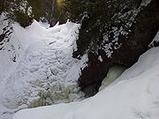
 At Gorge Falls, the Black River constricts to about 7 feet (2 m) across and drops 20 feet (6 m) into a steep gorge, creating masses of foam
as the water falls against the rocks below. Sandstone Falls drops a total of 25 feet (7.6 m) in two sections, a 5-foot initial drop (pictured) and a 20-foot second drop. Sandstone Falls is named for the sandstone
rocks along the riverbed that the river has cut
channels
through.
. The approach to this waterfall is the most strenuous: 200 steps are built on staircases and into the side of the hill, creating a very steep approach.
Upper Peninsula of Michigan
The Upper Peninsula of Michigan is the northern of the two major land masses that make up the U.S. state of Michigan. It is commonly referred to as the Upper Peninsula, the U.P., or Upper Michigan. It is also known as the land "above the Bridge" linking the two peninsulas. The peninsula is bounded...
of the U.S. state
U.S. state
A U.S. state is any one of the 50 federated states of the United States of America that share sovereignty with the federal government. Because of this shared sovereignty, an American is a citizen both of the federal entity and of his or her state of domicile. Four states use the official title of...
of Michigan
Michigan
Michigan is a U.S. state located in the Great Lakes Region of the United States of America. The name Michigan is the French form of the Ojibwa word mishigamaa, meaning "large water" or "large lake"....
, flowing mostly in Gogebic County
Gogebic County, Michigan
-Demographics:As of the census of 2000, there were 17,370 people, 7,425 households, and 4,581 families residing in the county. The population density was 16 people per square mile . There were 10,839 housing units at an average density of 10 per square mile...
into Lake Superior
Lake Superior
Lake Superior is the largest of the five traditionally-demarcated Great Lakes of North America. It is bounded to the north by the Canadian province of Ontario and the U.S. state of Minnesota, and to the south by the U.S. states of Wisconsin and Michigan. It is the largest freshwater lake in the...
at 46°40′03"N 90°02′57"W. Its source at 46°18′54"N 90°01′15"W is a boreal wetland
Wetland
A wetland is an area of land whose soil is saturated with water either permanently or seasonally. Wetlands are categorised by their characteristic vegetation, which is adapted to these unique soil conditions....
on the border with Iron County, Wisconsin
Iron County, Wisconsin
Iron County is a county located in the U.S. state of Wisconsin. As of 2000, the population was 6,861. Its county seat is Hurley.-Geography:According to the U.S...
. The northern section of the river, 14 miles (23 km) within the boundaries of the Ottawa National Forest
Ottawa National Forest
The Ottawa National Forest is a 1.0 million acre national forest in the Upper Peninsula of the U.S. state of Michigan. It includes much of Gogebic and Ontonagon counties, as well as slices of Iron, Houghton, Baraga, and Marquette counties. The forest is under the jurisdiction of the U.S...
, was designated a National Wild and Scenic River
National Wild and Scenic River
National Wild and Scenic River is a designation for certain protected areas in the United States.The National Wild and Scenic Rivers Act was an outgrowth of the recommendations of a Presidential commission, the Outdoor Recreation Resources Review Commission...
in 1992.
At the Lake Superior mouth of the Black River is Black River Harbor, a former fish
Fish
Fish are a paraphyletic group of organisms that consist of all gill-bearing aquatic vertebrate animals that lack limbs with digits. Included in this definition are the living hagfish, lampreys, and cartilaginous and bony fish, as well as various extinct related groups...
ing station where commercial fishermen brought in cargoes of lake trout
Lake trout
Lake trout is a freshwater char living mainly in lakes in northern North America. Other names for it include mackinaw, lake char , touladi, togue, and grey trout. In Lake Superior, they can also be variously known as siscowet, paperbellies and leans...
. The North Country Trail
North Country Trail
The North Country National Scenic Trail , which stretches approximately from Crown Point in eastern New York to Lake Sakakawea in central North Dakota in the United States, is the longest of the eleven National Scenic Trails authorized by Congress...
crosses the river here via a suspension
Suspension bridge
A suspension bridge is a type of bridge in which the deck is hung below suspension cables on vertical suspenders. Outside Tibet and Bhutan, where the first examples of this type of bridge were built in the 15th century, this type of bridge dates from the early 19th century...
footbridge
Footbridge
A footbridge or pedestrian bridge is a bridge designed for pedestrians and in some cases cyclists, animal traffic and horse riders, rather than vehicular traffic. Footbridges complement the landscape and can be used decoratively to visually link two distinct areas or to signal a transaction...
.
Waterfalls
The Wild and Scenic River section of the Black River of Gogebic County is known for the many waterfallWaterfall
A waterfall is a place where flowing water rapidly drops in elevation as it flows over a steep region or a cliff.-Formation:Waterfalls are commonly formed when a river is young. At these times the channel is often narrow and deep. When the river courses over resistant bedrock, erosion happens...
s produced as the river tumbles down from near Copper Peak
Copper Peak
Copper Peak is a ski flying hill located in Ironwood, Michigan, United States. Built in 1969, it remains the only ski flying facility in the Western Hemisphere. With a K-spot of 150 meters, Copper Peak has allowed jumps up to 158 meters...
to Lake Superior. The river drops more than 200 feet (61 m) over five separate named cataracts beginning 2 miles (3.2 km) from its mouth.
The first three named falls are smaller, farther apart, and have limited access. Some of these waterfalls are easily accessible from the parallel Black River Road (Gogebic County Route 513) north of Bessemer, Michigan
Bessemer, Michigan
Bessemer is a city in the U.S. state of Michigan. As of the 2010 census, the city population was 1,914. It is the county seat of Gogebic County....
, while other waterfalls require a more strenuous hike to see. Roadside trails provide access to Gorge Falls and Potawatomi Falls. The Black River Road was named a National Scenic Byway
National Scenic Byway
A National Scenic Byway is a road recognized by the United States Department of Transportation for its archeological, cultural, historic, natural, recreational, and/or scenic qualities. The program was established by Congress in 1991 to preserve and protect the nation's scenic but often...
in 1992. The trails to two of the Black River waterfalls, Gorge and Potawatomi, have been designated National Recreation Trail
National Recreation Trail
National Recreation Trail is a designation given to existing trails that contribute to health, conservation, and recreation goals in the United States. Over 1,000 trails in all 50 U.S. states, available for public use and ranging from less than a mile to in length, have been designated as NRTs...
s due to their unique stairway designs (to provide easier access down the steep slopes) and observation platforms.
Narrows, Chippewa, and Algonquin Falls
The first three waterfalls on the Black River as it approaches Lake Superior are Narrows Falls, Chippewa Falls, and AlgonquinAlgonquian peoples
The Algonquian are one of the most populous and widespread North American native language groups, with tribes originally numbering in the hundreds. Today hundreds of thousands of individuals identify with various Algonquian peoples...
Falls. They are the three smallest named waterfalls on the river. Narrows and Algonquin Falls are technically rapids or cascades. Chippewa falls drops nearly 10 feet (3 meters) over boulders and dead tree limbs. These area have limited access and are not often visited.
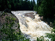
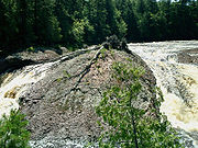
Great Conglomerate and Potawatomi Falls
Great Conglomerate Falls
Great Conglomerate Falls drops on the Black River in Michigan. It is split into two drops in the summertime when water is lower. The falls takes its name from the large conglomerate outcropping in the middle of the river that forms the segmented appearance of it....
is the southernmost (the Black River flows North) of the more publicized falls and the first large waterfall on the river's approach to Lake Superior. The river drops 30 feet (9 m) around a large piece of conglomerate rock
Conglomerate (geology)
A conglomerate is a rock consisting of individual clasts within a finer-grained matrix that have become cemented together. Conglomerates are sedimentary rocks consisting of rounded fragments and are thus differentiated from breccias, which consist of angular clasts...
, boulders and tree trunks into a deep gorge. Potawatomi Falls drops nearly 40 feet (12 m) in two sections around a piece of conglomerate rock, similar to Great Conglomerate Falls.
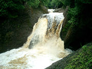
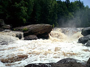
Gorge and Sandstone Falls
Foam
-Definition:A foam is a substance that is formed by trapping gas in a liquid or solid in a divided form, i.e. by forming gas regions inside liquid regions, leading to different kinds of dispersed media...
as the water falls against the rocks below. Sandstone Falls drops a total of 25 feet (7.6 m) in two sections, a 5-foot initial drop (pictured) and a 20-foot second drop. Sandstone Falls is named for the sandstone
Sandstone
Sandstone is a sedimentary rock composed mainly of sand-sized minerals or rock grains.Most sandstone is composed of quartz and/or feldspar because these are the most common minerals in the Earth's crust. Like sand, sandstone may be any colour, but the most common colours are tan, brown, yellow,...
rocks along the riverbed that the river has cut
Erosion
Erosion is when materials are removed from the surface and changed into something else. It only works by hydraulic actions and transport of solids in the natural environment, and leads to the deposition of these materials elsewhere...
channels
Channel (geography)
In physical geography, a channel is the physical confine of a river, slough or ocean strait consisting of a bed and banks.A channel is also the natural or human-made deeper course through a reef, sand bar, bay, or any shallow body of water...
through.
Rainbow Falls
Rainbow Falls is the northernmost waterfall on the Black River, less than 1 mile from Lake Superior. It is also the highest. Here, the water drops 45 feet (13.7 m) down into a rocky gorge. The waterfall creates much mist, which, on sunny days, creates a constant rainbowRainbow
A rainbow is an optical and meteorological phenomenon that causes a spectrum of light to appear in the sky when the Sun shines on to droplets of moisture in the Earth's atmosphere. It takes the form of a multicoloured arc...
. The approach to this waterfall is the most strenuous: 200 steps are built on staircases and into the side of the hill, creating a very steep approach.
Tributaries and features
From the mouth:- Rainbow Falls
- (left) Sagaigan Creek
- Sagaigan Lake
- Sandstone Falls
- Gorge Falls
- Potawatomi Falls
- Great Conglomerate Falls
- (left) Sand Island Creek
- Algonquin Falls
- (left) Kirby Creek
- Chippewa Falls
- (right) Reed Creek
- (left) Narrows Creek
- (left) Montowibo Creek
- (left) Sapsucker Creek
- (right) Sixmile Creek
- (right) Powder Mill Creek
- (left) Sellwood Creek
- (right) Kallander Creek
- BessemerBessemer, MichiganBessemer is a city in the U.S. state of Michigan. As of the 2010 census, the city population was 1,914. It is the county seat of Gogebic County....
- Bessemer
- (left) Abitosse Creek
- (left) Jackson Creek
- (right) Planter Creek
- (left) Berranger Creek
- (left) Connor Creek
- (left) Bowden Creek
- (left) Finnegan Creek
- (left) Alward Creek
- (right) McVichie Creek
- Gabbro Falls
- Neepikon Falls
- (left) Little Black River
- Sunday Lake
- WakefieldWakefield, MichiganWakefield is a city in Gogebic County in the US state of Michigan. It is located in the western Upper Peninsula. The population was 1,851 at the 2010 census....
- Ramsay
- (left) Sunset Creek
- Granite Falls
- (left) Hosking Creek
- (left) Devils Creek
- (right) Palms Creek
- (left) McDonald Creek
- McDonald Lake
- (left) Bice Creek
- (left) Mosinee Creek
- McDonald Lake
- (right) Wester Creek
- (left) Underwood Creek
- Black River Lake