

Belledonne
Encyclopedia
Belledonne is a mountain range
in the Dauphiné Alps
(part of the French Alps
) in southeast France. The southern end of the range forms the eastern wall of the mountains that surround the city of Grenoble
.
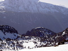
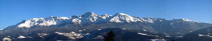
The range is noted for the spectacular scenery it provides the inhabitants of Grenoble, numerous ski areas, interesting geology, and a diverse range of alpine land types and uses.
, in a north-easterly direction (actually 35 degrees) for 65 km (40.4 mi) to roughly 45°33′N 6°17′E, near the town of Aiguebelle
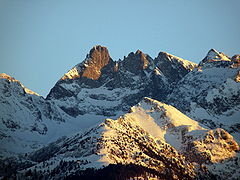
. The highest point is the Grand Pic de Belledonne, 2977 m (9,767.1 ft).
The range is delineated by several valleys which lie at relatively low altitude, including the Grésivaudan (which carries the Isère River
) on the west, the Arc River to the north and the Romanche River
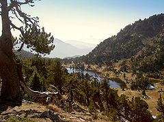
to the south. The range counts dozens of peaks over 2500 m (8,202.1 ft), more than 10 glaciers, and many alpine lakes, the highest of which is over 2400 m (7,874 ft) above sea level.
Geologically, Belledonne is a concatenation of ranges which are not physically separated; from north to south, these are: the Grand Arc, the Lauzière, the Sept-Laux, Belledonne proper, and the Taillefer.
Belledonne is a crystalline range. It initiated as a Paleozoic
peneplain
which was covered by Mesozoic
sediments, then raised and tilted during the Tertiary uplift of the Alps and subjected to glacial erosion during the Quaternary
. As a result of its geologic history, Belledonne alternates jagged peaks with gentle slopes.
Belledonne overlooks the fairly flat Isère Valley which lies only 220 m (721.8 ft) above sea level near Grenoble. Hence, all alpine vegetation zones are represented:
A significant feature is the Belledonne Balcony , which is a terrace or plateau some 30 km long on the western side of the range that provides a relatively level area intersected by narrow ravines eroded by rivers taking runoff from the snow levels higher up. The Balcony has supported diverse livestock-raising and other agricultural activity for a considerable period of time.

 The most spectacular glacier in Belledonne is , which is noted for its crevasses.
and the Romanche river). Most other passes are not much lower in elevation than their neighboring peaks.
At the turn of the 20th century, Joseph Paganon, a minister in several French governments, pushed for linking Laval to the Rivier-d'Allemont by road D528. But the roadwork stopped at an elevation of 1336 metres (4,383.2 ft) on the Gresivaudan
side, while work never even started on the other side (Eau d'Olle). Before the automobile era this pass was frequently used by locals to go from Gresivaudan to the Eau d'Olle valley, or even to go to the Maurienne
valley via the Glandon pass. Hannibal is believed to have passed the Pas de la Coche when he crossed the Alps with his army.

Belledonne and its lakes have played a major role in industrializing hydroelectricity
production as early as 1869 thanks to pioneer Aristide Bergès and his paper mills which tapped water from lake Crozet.
s, chamois
, ibex mountain goats and grouse
. Reportedly, wolves have returned since 1998, coming from Italy
and the press regularly echoes complaints from shepherds about wolves attacking their sheep
.
The ibex had completely disappeared from Belledonne. Early 1983, 13 females and 7 males were brought in from Switzerland
and by spring 2002, their population had risen to 900 heads.
Mountain range
A mountain range is a single, large mass consisting of a succession of mountains or narrowly spaced mountain ridges, with or without peaks, closely related in position, direction, formation, and age; a component part of a mountain system or of a mountain chain...
in the Dauphiné Alps
Dauphiné Alps
The Dauphiné Alps are a group of mountain ranges in southeastern France, west of the main chain of the Alps. They are separated from the Cottian Alps in the east by the Col du Galibier and the upper Durance valley; from the western Graian Alps in the north-east by the river Arc; from the lower...
(part of the French Alps
French Alps
The French Alps are those portions of the Alps mountain range which stand within France, located in the Rhône-Alpes and Provence-Alpes-Côte d'Azur regions....
) in southeast France. The southern end of the range forms the eastern wall of the mountains that surround the city of Grenoble
Grenoble
Grenoble is a city in southeastern France, at the foot of the French Alps where the river Drac joins the Isère. Located in the Rhône-Alpes region, Grenoble is the capital of the department of Isère...
.
The range is noted for the spectacular scenery it provides the inhabitants of Grenoble, numerous ski areas, interesting geology, and a diverse range of alpine land types and uses.
Geography
The Belledonne range is approximately 60 km (37.3 mi) long by between 10 km (6.2 mi) wide and runs from roughly 45°03′N 5°48′E, 16 km (9.9 mi) south-south-east of the city of GrenobleGrenoble
Grenoble is a city in southeastern France, at the foot of the French Alps where the river Drac joins the Isère. Located in the Rhône-Alpes region, Grenoble is the capital of the department of Isère...
, in a north-easterly direction (actually 35 degrees) for 65 km (40.4 mi) to roughly 45°33′N 6°17′E, near the town of Aiguebelle
Aiguebelle
Aiguebelle is a commune in the Savoie department in the Rhône-Alpes region in south-eastern France.-References:*...
. The highest point is the Grand Pic de Belledonne, 2977 m (9,767.1 ft).
The range is delineated by several valleys which lie at relatively low altitude, including the Grésivaudan (which carries the Isère River
Isère River
The Isère is a 286 km long river in southeastern France, in the Rhône-Alpes région. Its source is in the Alps on the border with Italy, near the ski resort Val d'Isère. It flows into the Rhône River in Pont-de-l'Isère, a few km north of Valence...
) on the west, the Arc River to the north and the Romanche River
Romanche
The Romanche is a 78 km long mountain river in southeastern France, right tributary of the Drac . Its source is in the northern part of the Massif des Écrins, Dauphiné Alps. It flows into the Drac in Champ-sur-Drac, south of Grenoble. The road from Grenoble to Briançon over the Col du Lautaret runs...
to the south. The range counts dozens of peaks over 2500 m (8,202.1 ft), more than 10 glaciers, and many alpine lakes, the highest of which is over 2400 m (7,874 ft) above sea level.
Geologically, Belledonne is a concatenation of ranges which are not physically separated; from north to south, these are: the Grand Arc, the Lauzière, the Sept-Laux, Belledonne proper, and the Taillefer.
Belledonne is a crystalline range. It initiated as a Paleozoic
Paleozoic
The Paleozoic era is the earliest of three geologic eras of the Phanerozoic eon, spanning from roughly...
peneplain
Peneplain
A peneplain is a low-relief plain representing the final stage of fluvial erosion during times of extended tectonic stability. The existence of peneplains, and peneplanation as a geomorphological process, is not without controversy, due to a lack of contemporary examples and uncertainty in...
which was covered by Mesozoic
Mesozoic
The Mesozoic era is an interval of geological time from about 250 million years ago to about 65 million years ago. It is often referred to as the age of reptiles because reptiles, namely dinosaurs, were the dominant terrestrial and marine vertebrates of the time...
sediments, then raised and tilted during the Tertiary uplift of the Alps and subjected to glacial erosion during the Quaternary
Quaternary
The Quaternary Period is the most recent of the three periods of the Cenozoic Era in the geologic time scale of the ICS. It follows the Neogene Period, spanning 2.588 ± 0.005 million years ago to the present...
. As a result of its geologic history, Belledonne alternates jagged peaks with gentle slopes.
Belledonne overlooks the fairly flat Isère Valley which lies only 220 m (721.8 ft) above sea level near Grenoble. Hence, all alpine vegetation zones are represented:
- Hill zone: coppices of pubescent oak on South facing slopes , hornbeam, common maple.
- MontaneMontaneIn biogeography, montane is the highland area located below the subalpine zone. Montane regions generally have cooler temperatures and often have higher rainfall than the adjacent lowland regions, and are frequently home to distinct communities of plants and animals.The term "montane" means "of the...
zone: beech, birch, aspen, English oak, sycamore maple, goat willow, then fir and spruce. - Subalpine zone: moors and sparse stands of spruce, mugho pine, stone pine, and silver birch.
- Alpine zone: grassland, scree and rock.
 |
A significant feature is the Belledonne Balcony , which is a terrace or plateau some 30 km long on the western side of the range that provides a relatively level area intersected by narrow ravines eroded by rivers taking runoff from the snow levels higher up. The Balcony has supported diverse livestock-raising and other agricultural activity for a considerable period of time.
Main summits
| Name | Elevation |
|---|---|
| Grand Pic de Belledonne (Le) | 2977 m (9,767.1 ft) |
| Croix de Belledonne (La) | 2929 m (9,609.6 ft) |
| Rocher Blanc (Le) | 2927 m (9,603 ft) |
| Aiguilles de l'Argentière (Les) | 2915 m (9,563.6 ft) |
| Rocher Badon (Le) | 2912 m (9,553.8 ft) |
| Pyramide (La) | 2912 m (9,553.8 ft) |
| Puy Gris (Le) | 2908 m (9,540.7 ft) |
| Bec d'Arguille (Le) | 2891 m (9,484.9 ft) |
| Aiguille d'Olle (L') | 2885 m (9,465.2 ft) |
| Rocher d'Arguille (Le) | 2885 m (9,465.2 ft) |
| Pointe de Comberousse (La) | 2866 m (9,402.9 ft) |
| Grande Lance d'Allemond (La) | 2842 m (9,324.1 ft) |
| Charmet de l'Aiguille (Le) | 2826 m (9,271.7 ft) |
| Pointe de la Porte d'Eglise (La) | 2812 m (9,225.7 ft) |
| Pic du Frêne Pic du Frêne The Pic du Frêne is a mountain in the Belledonne Massif in Savoie, France.... (Le) |
2807 m (9,209.3 ft) |
| Pic du Grand Doménon (Le) | 2802 m (9,192.9 ft) |
| Grand Morétan (Le) | 2800 m (9,186.4 ft) |
| Grande Lance de Domène (La) | 2790 m (9,153.5 ft) |
| Grand Charnier d'Allemont (Le) | 2777 m (9,110.9 ft) |
| Pic Couttet (Le) | 2764 m (9,068.2 ft) |
| Grand Crozet (Le) | 2762 m (9,061.7 ft) |
| Pic de la Grande Valloire (Le) | 2758 m (9,048.6 ft) |
| Selle du Puy Gris (La) | 2758 m (9,048.6 ft) |
| Rocher de l'Homme (Le) | 2755 m (9,038.7 ft) |
| Roche Rousse | 2753 m (9,032.2 ft) |
| Pic Lamartine (Le) | 2752 m (9,028.9 ft) |
| Grande Lauzière (La) | 2741 m (8,992.8 ft) |
Main glaciers
- Glacier de la Sitre
- Glacier de Freydane
- Glacier de l'Amiante
- Glacier du Rocher Blanc
- Glacier de la Combe Madame
- Glacier de l'Argentière
- Glacier d'Arguille
- Glacier du Puy Gris
- Glacier du Gleyzin
- Glacier de Claran
Main passes
There is no road that cuts across Belldonne. The Pas de la Coche pass is the only natural break point in the range, between Belledonne proper and the 7 Laux range. It is the only point below 2000 metres (6,561.7 ft) on the Belledonne ridge (the main water divide between the Isère riverIsère River
The Isère is a 286 km long river in southeastern France, in the Rhône-Alpes région. Its source is in the Alps on the border with Italy, near the ski resort Val d'Isère. It flows into the Rhône River in Pont-de-l'Isère, a few km north of Valence...
and the Romanche river). Most other passes are not much lower in elevation than their neighboring peaks.
At the turn of the 20th century, Joseph Paganon, a minister in several French governments, pushed for linking Laval to the Rivier-d'Allemont by road D528. But the roadwork stopped at an elevation of 1336 metres (4,383.2 ft) on the Gresivaudan
Grésivaudan
The Grésivaudan is a valley of the French Alps, situated mostly in the Isère. Etymologically, Graisivaudan comes from roots meaning "Grenoble" and "valley". It comprises the alluvial plain of the Isère River from Grenoble to the confluence of the Arc; or, more recently, the entire valley of the...
side, while work never even started on the other side (Eau d'Olle). Before the automobile era this pass was frequently used by locals to go from Gresivaudan to the Eau d'Olle valley, or even to go to the Maurienne
Maurienne
Maurienne is one of the provinces of Savoy, corresponding to the arrondissement of Saint-Jean-de-Maurienne in France. It is also the original name of the capital of the province, now Saint-Jean-de-Maurienne.-Location:...
valley via the Glandon pass. Hannibal is believed to have passed the Pas de la Coche when he crossed the Alps with his army.
| Name | Elevation |
|---|---|
| Pra (Col de la ) | 2171 m (7,122.7 ft) |
| Belledonne (Col de) | 2785 m (9,137.1 ft) |
| Freydanne (Col de) | 2645 m (8,677.8 ft) |
| Mine de Fer (Col de la) | 2400 m (7,874 ft) |
| Roche Fendue (Brèche de) | 2482 m (8,143 ft) |
| Coche (Pas de la) | 1989 m (6,525.6 ft) |
| Sept Laux (Col des) | 2184 m (7,165.4 ft) |
| Croix (Col de la) | 2529 m (8,297.2 ft) |
| Tepey (Col du) | 2716 m (8,910.8 ft) |
| Valloire (Col de la) | 2751 m (9,025.6 ft) |
| Merlet (Col du) | 2286 m (7,500 ft) |
| Bourbière (Col de la) | 2352 m (7,716.5 ft) |
| Frèche (Col de la) | 2183 m (7,162.1 ft) |
| Perrière (Col de la) | 2003 m (6,571.5 ft) |
| Perche (Col de la) | 1984 m (6,509.2 ft) |
| Roche Noire (Col de) | 2629 m (8,625.3 ft) |
| Balmette (Col de la) | 2667 m (8,750 ft) |
Main lakes
 |
Belledonne and its lakes have played a major role in industrializing hydroelectricity
Hydroelectricity
Hydroelectricity is the term referring to electricity generated by hydropower; the production of electrical power through the use of the gravitational force of falling or flowing water. It is the most widely used form of renewable energy...
production as early as 1869 thanks to pioneer Aristide Bergès and his paper mills which tapped water from lake Crozet.
| Name | Elevation | Group |
|---|---|---|
| Achard (Lac) | 1917 m (6,289.4 ft) | |
| Robert (Lac) | 1998 m (6,555.1 ft) | |
| Longet (Lac) | 2027 m (6,650.3 ft) | |
| Merlat (Lac) | 2044 m (6,706 ft) | |
| Crozet (Lac du) | 1974 m (6,476.4 ft) | |
| Petit Doménon (Lac du) | 2380 m (7,808.4 ft) | |
| Grand Doménon (Lac du) | 2385 m (7,824.8 ft) | |
| Sitre (Lac de la) | 1952 m (6,404.2 ft) | |
| Belledonne (Lac de) | 2163 m (7,096.5 ft) | |
| Blanc (Lac) | 2161 m (7,089.9 ft) | |
| Crop (Lac de) | 1906 m (6,253.3 ft) | |
| Agnelin (Lac de l') | 2327 m (7,634.5 ft) | |
| Jeplan (Lac) | 2144 m (7,034.1 ft) | |
| Sagne (Lac de la) | 2065 m (6,774.9 ft) | |
| Croix (Lac de la) | 2415 m (7,923.2 ft) | |
| Folle (Lac de la) | 2142 m (7,027.6 ft) | |
| Blanc (Lac) | 2124 m (6,968.5 ft) | |
| Noir (Lac) | 2268 m (7,440.9 ft) | |
| Balmettes (Lac des) | 2196 m (7,204.7 ft) | |
| Corne (Lac de la) | 2083 m (6,834 ft) | 7 Laux |
| Cos (Lac du) | 2182 m (7,158.8 ft) | 7 Laux |
| Blanc (Lac) | 2248 m (7,375.3 ft) | 7 Laux |
| Cottepens (Lac) | 2128 m (6,981.6 ft) | 7 Laux |
| Carré (Lac) | 2128 m (6,981.6 ft) | 7 Laux |
| Motte (Lac de la) | 2128 m (6,981.6 ft) | 7 Laux |
| Noir (Lac) | 2091 m (6,860.2 ft) | 7 Laux |
Ski resorts
There are 4 main ski resorts in Belledonne, from South to North:- ChamrousseChamrousseChamrousse is a commune in the Isère department in south-eastern France.The majestic mountain scenery towering above Grenoble is, for the most part, formed by the Belledonne range...
- Le Collet d'Allevard
- Les Sept Laux
- L'Espace Nordique du Barioz
Origin of the name
The origin of the name is not clear. The phrase belle donne means beautiful women in Italian. It does not appear to mean that in Occitan, and since Occitan is the ancient regional language, would have been a more likely source of ancient names than Italian. Nevertheless, from one angle the highest peak, the Grand Pic du Belledonne allegedly looks like a woman holding a baby. Other suggested derivations are from the celtic donne meaning valley, hence beautiful valleys, or indo-European bal, meaning elevated rock, which evolved into bel, then belle. It is difficult without evidence to determine the validity of these derivations.Fauna
The mountains are home to marmotMarmot
The marmots are a genus, Marmota, of squirrels. There are 14 species in this genus.Marmots are generally large ground squirrels. Those most often referred to as marmots tend to live in mountainous areas such as the Alps, northern Apennines, Eurasian steppes, Carpathians, Tatras, and Pyrenees in...
s, chamois
Chamois
The chamois, Rupicapra rupicapra, is a goat-antelope species native to mountains in Europe, including the Carpathian Mountains of Romania, the European Alps, the Tatra Mountains, the Balkans, parts of Turkey, and the Caucasus. The chamois has also been introduced to the South Island of New Zealand...
, ibex mountain goats and grouse
Grouse
Grouse are a group of birds from the order Galliformes. They are sometimes considered a family Tetraonidae, though the American Ornithologists' Union and many others include grouse as a subfamily Tetraoninae in the family Phasianidae...
. Reportedly, wolves have returned since 1998, coming from Italy
Italy
Italy , officially the Italian Republic languages]] under the European Charter for Regional or Minority Languages. In each of these, Italy's official name is as follows:;;;;;;;;), is a unitary parliamentary republic in South-Central Europe. To the north it borders France, Switzerland, Austria and...
and the press regularly echoes complaints from shepherds about wolves attacking their sheep
.
The ibex had completely disappeared from Belledonne. Early 1983, 13 females and 7 males were brought in from Switzerland
Switzerland
Switzerland name of one of the Swiss cantons. ; ; ; or ), in its full name the Swiss Confederation , is a federal republic consisting of 26 cantons, with Bern as the seat of the federal authorities. The country is situated in Western Europe,Or Central Europe depending on the definition....
and by spring 2002, their population had risen to 900 heads.