
Dauphiné Alps
Encyclopedia
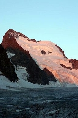
The Dauphiné
Alps
are a group of mountain ranges in southeastern France
, west of the main chain of the Alps. They are separated from the Cottian Alps
in the east by the Col du Galibier
and the upper Durance
valley; from the western Graian Alps
(Vanoise Massif
) in the north-east by the river Arc
; from the lower ranges Vercors Plateau
and Chartreuse Mountains
in the west by the rivers Drac
and Isère
. Many peaks rise to more than 10,000 feet (3,050 m), with Barre des Écrins
(4,102 m) the highest.
Mountain ranges within the Dauphiné Alps include the Massif des Écrins
(in the Parc national des Écrins), Belledonne
, the Taillefer
range and the mountains of Matheysine
.
of the Dauphiné Alps are:
Dauphiné
The Dauphiné or Dauphiné Viennois is a former province in southeastern France, whose area roughly corresponded to that of the present departments of :Isère, :Drôme, and :Hautes-Alpes....
Alps
Alps
The Alps is one of the great mountain range systems of Europe, stretching from Austria and Slovenia in the east through Italy, Switzerland, Liechtenstein and Germany to France in the west....
are a group of mountain ranges in southeastern France
France
The French Republic , The French Republic , The French Republic , (commonly known as France , is a unitary semi-presidential republic in Western Europe with several overseas territories and islands located on other continents and in the Indian, Pacific, and Atlantic oceans. Metropolitan France...
, west of the main chain of the Alps. They are separated from the Cottian Alps
Cottian Alps
The Cottian Alps are a mountain range in the southwestern part of the Alps. They form the border between France and Italy...
in the east by the Col du Galibier
Col du Galibier
Col du Galibier is a mountain pass in the southern region of the French Dauphiné Alps near Grenoble. It is the ninth highest paved road in the Alps and the sixth highest mountain pass. It is often the highest point of the Tour de France....
and the upper Durance
Durance
The Durance is a major river in south-eastern France.Its source is in the south-western Alps, in Montgenèvre ski resort near Briançon and it flows south-west through the following départements and cities:* Hautes-Alpes: Briançon, Embrun.* Alpes-de-Haute-Provence: Sisteron, Manosque.* Vaucluse:...
valley; from the western Graian Alps
Graian Alps
The Graian Alps are a mountain range in the western part of the Alps. They are located in France , Italy , and Switzerland...
(Vanoise Massif
Vanoise Massif
The Vanoise massif is a mountain range in the Graian Alps in the western part of the Alps.-Principal summits:The principal summits of the Vanoise massif are:...
) in the north-east by the river Arc
Arc (Savoie)
The Arc is a 128 km long river in the Savoie département of south-eastern France. It is a left tributary of the Isère River, which it joins at Chamousset, approximately 15 km downstream from Albertville. Its source is near the border with Italy, in the Graian Alps, northeast of Bonneval-sur-Arc...
; from the lower ranges Vercors Plateau
Vercors Plateau
The Vercors is a range of plateaux and mountains in the départements of Isère and Drôme in the French Prealps. It lies west of the Dauphiné Alps, from which it is separated by the rivers Drac and Isère...
and Chartreuse Mountains
Chartreuse Mountains
The Chartreuse Mountains is a mountain range in eastern France, stretching to the north from the city of Grenoble to the Lac du Bourget. It is the southernmost range in the Jura Mountains and belongs to the French Prealps....
in the west by the rivers Drac
Drac River
The Drac is a 130 km long river in southeastern France, left tributary of the Isère. It is formed by the confluence of the Drac Noir and the Drac Blanc, that both rise in the southern part of the Massif des Écrins. It flows through several reservoirs, including the Lac de Monteynard-Avignonet....
and Isère
Isère River
The Isère is a 286 km long river in southeastern France, in the Rhône-Alpes région. Its source is in the Alps on the border with Italy, near the ski resort Val d'Isère. It flows into the Rhône River in Pont-de-l'Isère, a few km north of Valence...
. Many peaks rise to more than 10,000 feet (3,050 m), with Barre des Écrins
Barre des Écrins
The Barre des Écrins is a mountain in the French Alps, the highest point of the Massif des Écrins, and the most southerly alpine peak in Europe that is higher than 4,000 metres.- Geography :...
(4,102 m) the highest.
Mountain ranges within the Dauphiné Alps include the Massif des Écrins
Massif des Écrins
The mountains of the Massif des Écrins form the core of the Écrins National Park in France.-Mountains:*Barre des Écrins 4102 m*La Meije 3983 m*Ailefroide 3954 m*Mont Pelvoux 3946 m*Pic Sans Nom 3913 m*Pic Gaspard 3883 m*Le Râteau 3809 m...
(in the Parc national des Écrins), Belledonne
Belledonne
Belledonne is a mountain range in the Dauphiné Alps in southeast France. The southern end of the range forms the eastern wall of the mountains that surround the city of Grenoble....
, the Taillefer
Taillefer
Taillefer was the surname of a Norman ioglere whose exact name and place of birth are unknown . He travelled to England during the Norman conquest of England of 1066, in the train of William the Conqueror...
range and the mountains of Matheysine
Matheysine
Matheysine is a French Natural region located in the Alps at the south of the Isère département. Its relief is a plateau surroundered by mountains. Matheysine is also called Plateau Matheysin.-Geography:...
.
Peaks
The chief peaks of the Dauphiné Alps are:| Barre des Écrins Barre des Écrins The Barre des Écrins is a mountain in the French Alps, the highest point of the Massif des Écrins, and the most southerly alpine peak in Europe that is higher than 4,000 metres.- Geography :... | 4102 meters | (13,459 feet) | Pic Felix Neff | 3222 meters | (10,571 feet) | |
| Meije Meije La Meije is a mountain in the Massif des Écrins range, located at the border of the Hautes-Alpes and Isère départements. It overlooks the nearby village of La Grave, a mountaineering centre and ski resort, well-known for its off-piste and extreme skiing possibilities.La Meije is composed of three... | 3987 meters | (13,081 feet) | Vieux Chaillol | 3163 meters | (10,378 feet) | |
| Ailefroide Ailefroide The Ailefroide is a mountain in the Massif des Écrins in the French Alps, and is the third highest peak in the Dauphiné Alps after the Barre des Écrins and La Meije. It lies at the south-western end of the Mont Pelvoux–Pic Sans Nom–Ailefroide ridge.... | 3954 meters | (12,972 feet) | Tete de Vautisse | 3162 meters | (10,375 feet) | |
| Mont Pelvoux Mont Pelvoux Mont Pelvoux is a mountain in the Massif des Écrins in the French Alps.For many years Mont Pelvoux was believed to be the highest mountain in the region since the higher Barre des Écrins cannot be seen from the Durance valley.... | 3946 meters | (12,946 feet) | Grand Pinier | 3120 meters | (10,237 feet) | |
| Pic Sans Nom Pic Sans Nom The Pic Sans Nom is a mountain in the Massif des Écrins in the French Alps. It lies in the middle of the steep mountain mass that runs south-west from Mont Pelvoux to the Ailefroide.... | 3913 meters | (12,838 feet) | Pic de Parieres | 3050 meters | (10,007 feet) | |
| Pic Gaspard Pic Gaspard Pic Gaspard is a mountain in the French Alps, in the Massif des Écrins.... | 3880 meters | (12,730 feet) | Mourre Froid | 2996 meters | (9830 feet) | |
| Pic Coolidge | 3756 meters | (12,323 feet) | Grand Pic de Belledonne | 2977 meters | (9767 feet) | |
| Grande Ruine | 3754 meters | (12,317 feet) | Rocherblanc (Sept Laux) | 2931 meters | (9617 feet) | |
| Rateau | 3754 meters | (12,317 feet) | Taillefer Taillefer Taillefer was the surname of a Norman ioglere whose exact name and place of birth are unknown . He travelled to England during the Norman conquest of England of 1066, in the train of William the Conqueror... | 2861 meters | (9387 feet) | |
| Les Bans Les Bans Les Bans is a mountain in the Massif des Écrins in the Dauphiné Alps, first climbed by W. A. B. Coolidge, Christian Almer and U. Almer on July 14, 1878.There are three main summits on the mountain:* South summit 3,669 m* North-west summit 3,630 m... | 3669 meters | (12,037 feet) | Tete de l'Obiou | 2793 meters | (9164 feet) | |
| Montagne des Agneaux | 3660 meters | (12,008 feet) | Pic du Frene Pic du Frêne The Pic du Frêne is a mountain in the Belledonne Massif in Savoie, France.... | 2810 meters | (9219 feet) | |
| Sommet des Rouies | 3634 meters | (11,923 feet) | Grand Ferrand | 2761 meters | (9059 feet) | |
| Aiguille du Plat de la Selle Aiguille du Plat de la Selle The Aiguille du Plat de la Selle, 3,596 m, is a mountain in the Soreiller group of the Dauphiné Alps in south-eastern France. Ascents of the mountain are via Saint-Christophe-en-Oisans or the Soreiller hut.-External links:*... | 3596 meters | Pic de Bure (Aurouse) | 2712 meters | (8898 feet) | ||
| Olan Olan (mountain) The Olan is a mountain in the Massif des Écrins in the French Alps. It dominates the valleys of Valgaudemar, Valjouffrey, and Vénéon in the heart of Écrins National Park.- Climbing :... | 3564 meters | (11,735 feet) | ||||
| Pic Bonvoisin | 3560 meters | (11,680 feet) | ||||
| Aiguilles d'Arves Aiguilles d'Arves The Aiguilles d’Arves is a mountain in the Arves massif in the French Alps. The mountain, comprising three separate peaks , is the highest point of the massif, and is located in the department of Savoie.- Geography :... (highest point) | 3514 meters | (11,529 feet) | ||||
| Grandes Rousses | 3473 meters | (11,395 feet) | ||||
| Roche de la Muzelle Roche de la Muzelle - Guides :* Le massif des ecrins - les 100 plus belles courses et randonnées, by Gaston Rebuffat... | 3459 meters | (11,349 feet) | ||||
| Sirac Sirac Sirač is a settlement and municipality in Bjelovar-Bilogora County, Croatia. There are 2,546 inhabitants; 71% are Croats, 14% Serbs, and 10% Czechs... | 3438 meters | (11,280 feet) |
Passes
The chief passesMountain pass
A mountain pass is a route through a mountain range or over a ridge. If following the lowest possible route, a pass is locally the highest point on that route...
of the Dauphiné Alps are:
| name | location | type | elevation (m/ft) |
|---|---|---|---|
| Brèche de la Meije Brèche de la Meije The Brèche de la Meije is a high mountain pass in the Dauphiné Alps in Savoie in southeastern France.It is in the massif of Écrins in the Écrins National Park.... | La Berarde to la Grave | snow | 3300/10,827 |
| Brèche des Grandes Rousses | Allemont to Clavans | snow | 3100/10,171 |
| Brèche de Valsenestre | Bourg d'Oisans to Valsenestre | foot path | 2634/8642 |
| Col Bayard Col Bayard Col Bayard is a mountain pass through the Dauphiné Alps in the department of Isère in France.It connects the communities of La Mure and Gap.-See also:* List of highest paved roads in Europe* List of mountain passes... | La Mure La Mure La Mure is a commune in the Isère département in south-eastern France.It is located south of Grenoble on the plateau Matheysin.-Neighbour communes:* Prunières* Sousville* Susville* Ponsonnas* Pierre-Châtel* Saint-Honoré-Main sights:... to Gap Gap, Hautes-Alpes Gap is a commune in southeastern France, the capital of the Hautes-Alpes department.-Geography:An Alpine crossroads at the intersection of D994 and Route nationale 85 the Route Napoléon, Gap lies above sea level along the right bank of the Luye River... | road | 1246/4088 |
| Col de la Casse Deserte | La Berarde to La Grave | snow | 3510/11,516 |
| Col de la Croix de Fer Col de la Croix de Fer Col de la Croix de Fer is a high mountain pass in the French Alps linking Le Bourg-d'Oisans and Saint-Jean-de-Maurienne.-Details of climb:... | Bourg d'Oisans to Saint-Jean-d'Arves | road | 2062/6765 |
| Col de la Croix Haute Col de la Croix Haute Col de la Croix-Haute is a high mountain pass in the French Dauphiné Alps on the border of the Isère and Drôme departments, linking the towns of Clelles and Mens in the North with Lus-la-Croix-Haute in the South.-See also:... | Grenoble Grenoble Grenoble is a city in southeastern France, at the foot of the French Alps where the river Drac joins the Isère. Located in the Rhône-Alpes region, Grenoble is the capital of the department of Isère... to Serres Serres, Hautes-Alpes Serres is a commune in the Hautes-Alpes department in southeastern France.-History:Serres is located in a region called Dauphiné which, centuries ago, was traditionally given as a fief to the Dauphin .... and Gap | road, railroad | 1167/3829 |
| Col de la Lauze | Saint-Christophe-en-Oisans Saint-Christophe-en-Oisans Saint-Christophe-en-Oisans is a commune in the Isère department in south-eastern France.-References:*... to La Grave La Grave La Grave is a commune in the Hautes-Alpes department in southeastern France.It is a small ski resort in the French Alps, dominated by La Meije . It was the birthplace of Nicolas de Nicolay; adventurer and Geographer Ordinary to Henry II of France.... | snow | 3543/11,625 |
| Col de l'Alpe de Vénosc | Vénosc Vénosc Vénosc is a commune in the Isère department in south-eastern France.... to Les Deux Alpes Les Deux Alpes Les Deux Alpes is a ski resort in the French Isère département. The village sits at 1650m and lifts run to 3600m . It has the largest skiable glacier in Europe and is France's second oldest ski resort behind Chamonix, where the largest mountain in western Europe is located, Mont Blanc... | bridle path | 1660/5446 |
| Col de la Muande | St Christophe to the Val Gaudemar | snow | 3059/10,037 |
| Col de la Muzelle | St Christophe to Valsenestre | foot path | 2500/8202 |
| Col d'Arsine | La Grave to Le Monêtier-les-Bains | bridle path | 2400/7874 |
| Col de la Temple | La Berarde to Vallouise | snow | 3283/10,772 |
| Col de la Vaurze | Val Gaudemar to Valjouffrey Valjouffrey Valjouffrey is a commune in the Isère department in south-eastern France.... | foot path | 2600/8531 |
| Col de l'Eychauda | Vallouise to Le Monêtier-les-Bains Le Monêtier-les-Bains Le Monêtier-les-Bains is a commune in the Hautes-Alpes department in southeastern France.-Population:-Skiing:Monetier's slopes are a part of the extensive Serre Chevalier ski area. There are 7 chairlifts and 4 drag lifts with the highest skiing in the domain at 2760m.-Geography:Le... | bridle path | 2429/7970 |
| Col de l'Infernet | La Grave to Saint-Jean-d'Arves | foot path | 2690/8826 |
| Col de Martignare | La Grave to Saint-Jean-d'Arves | foot path | 2600/8531 |
| Col des Aiguilles d'Arves | Valloire Valloire Valloire is a commune in the Savoie department in the Rhône-Alpes region in south-eastern France.The ski resort Valloire-Galibier is located in the commune, at the foot of the Col du Galibier and next to the ski resort of Valmeinier, France.... to Saint-Jean-d'Arves Saint-Jean-d'Arves Saint-Jean-d'Arves is a commune in the Savoie department in the Rhône-Alpes region in south-eastern France.It is a ski resort, part of the larger Les Sybelles ski area.-External links:*... | snow | 3150/10,335 |
| Col des Avalanches | La Berarde to Vallouise Vallouise Vallouise is a commune in the Hautes-Alpes department in southeastern France.-Population:-References:*... | snow | 3511/11,520 |
| Col des Ecrins | La Berarde to Vallouise | snow | 3415/11,205 |
| Col des Prés Nouveaux | Le Freney to Saint-Jean-d'Arves | bridle path | 2293/7523 |
| Col des Quirlies | Saint-Jean-d'Arves to Clavans | snow | 2950/9679 |
| Col des Sept Laux | Allevard Allevard Allevard, also Allevard-les-Bains is a commune in the Isère department in south-eastern France.... to Bourg d'Oisans | bridle path | 2184/7166 |
| Col des Tourettes | Orcières to Châteauroux-les-Alpes Châteauroux-les-Alpes Châteauroux-les-Alpes is a commune in the Hautes-Alpes department in southeastern France.-Population:-References:*... | bridle path | 2580/8465 |
| Col de Val Estrete | Val Gaudemar to Champoléon | foot path | 2620/8596 |
| Col de Vallonpierre | Val Gaudemar to Champoléon | foot path | 2620/8596 |
| Col d'Orcières | Dormillouse to Orcières Orcières Orcières is a commune in the Hautes-Alpes department in southeastern France.-Population:-References:*... | bridle path | 2700/8859 |
| Col d'Ornon Col d'Ornon Col d'Ornon is a mountain pass through the Dauphiné Alps in the department of Isère in France.It connects the communities of Bourg d'Oisans and La Mure.-See also:* List of highest paved roads in Europe* List of mountain passes... | Bourg d'Oisans to La Mure La Mure La Mure is a commune in the Isère département in south-eastern France.It is located south of Grenoble on the plateau Matheysin.-Neighbour communes:* Prunières* Sousville* Susville* Ponsonnas* Pierre-Châtel* Saint-Honoré-Main sights:... | road | 1360/4462 |
| Col du Clot des Cavales | La Berarde to La Grave | snow | 3128/10,263 |
| Col du Galibier Col du Galibier Col du Galibier is a mountain pass in the southern region of the French Dauphiné Alps near Grenoble. It is the ninth highest paved road in the Alps and the sixth highest mountain pass. It is often the highest point of the Tour de France.... | Col du Lautaret Col du Lautaret Col du Lautaret is a high mountain pass in the department of Hautes-Alpes in France.It marks the boundary between the valleys of the Romanche and the Guisane, a tributary of the Durance which has its source at the col. The valleys are linked by national route 91... to Saint-Michel-de-Maurienne Saint-Michel-de-Maurienne Saint-Michel-de-Maurienne is a commune in the Savoie department in the Rhône-Alpes region in south-eastern France.-See also:*Communes of the Savoie department*The 1917 Saint-Michel-de-Maurienne derailment, which killed several hundred French troops.... | road | 2658/8721 |
| Col du Glacier Blanc | La Grave to Vallouise | snow | 3308/10,854 |
| Col du Glandon Col du Glandon Col du Glandon is a high mountain pass in the Dauphiné Alps in Savoie, France, linking Bourg d'Oisans to La Chambre. It is situated between the Belledonne, Grandes Rousses and Arvan-Villards mountain ranges, west of the Col de la Croix de Fer... | Bourg d'Oisans to La Chambre La Chambre La Chambre is a commune in the Savoie department in the Rhône-Alpes region in south-eastern France.-References:*... | road | 1951/6401 |
| Col du Goleon | La Grave to Valloire | foot path | 2880/9449 |
| Col du Lautaret Col du Lautaret Col du Lautaret is a high mountain pass in the department of Hautes-Alpes in France.It marks the boundary between the valleys of the Romanche and the Guisane, a tributary of the Durance which has its source at the col. The valleys are linked by national route 91... | Briançon Briançon Briançon a commune in the Hautes-Alpes department in the Provence-Alpes-Côte d'Azur region in southeastern France. It is a sub-prefecture of the department.... to Bourg d'Oisans | road | 2075/6808 |
| Col du Loup du Valgaudemar | Vallouise to the Val Gaudemar | snow | 3112/10,210 |
| Col du Says | La Berarde to the Val Gaudemar | snow | 3136/10,289 |
| Col du Sele | La Berarde to Vallouise | snow | 3302/10,834 |
| Col du Sellar | Vallouise to the Val Gaudemar | snow | 3067/10,063 |
| Col Emile Pic | La Grave to Vallouise | snow | 3502/11,490 |
| Col Lombard | La Grave to Saint-Jean-d'Arves | snow | 3100/10,171 |
| Pas de la Cavale | Vallouise to Champoléon Champoléon Champoléon is a commune in the Hautes-Alpes department in southeastern France.-Population:-References:*... | dirt road | 2740/8990 |