

Bankhead Highway
Encyclopedia
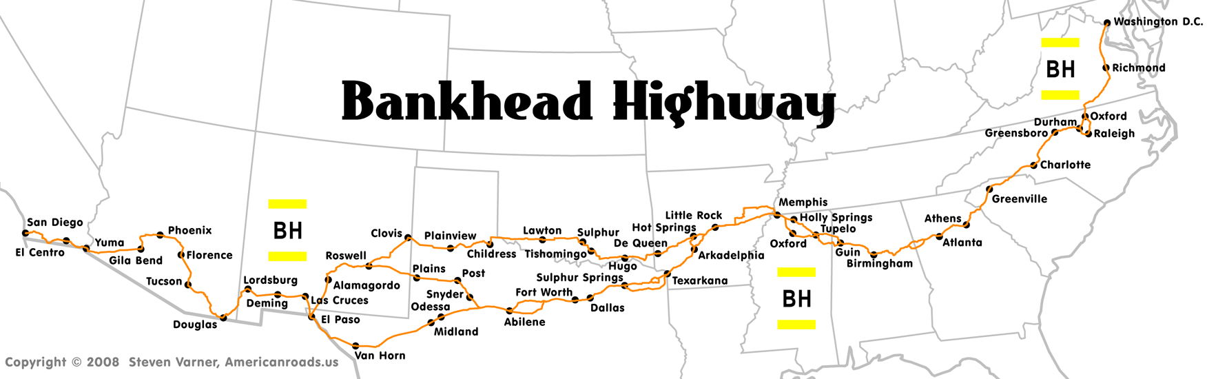
The Bankhead Highway was a United States
cross-country automobile
highway
connecting Washington, D.C.
and San Diego
. It was part of the National Auto Trail
system. The road was named for Alabama
politician
John Hollis Bankhead, a leader in the early national road building movement. In later years, several stretches of US-78 in northwest Alabama were renamed for Bankhead's son, former U.S. Representative and Speaker of the House William B. Bankhead
.
, following US 1 into Virginia.
, the route followed US 1 through Fredericksburg
and Richmond
. At South Hill
the route turned southwest onto US 58 and followed it to Clarksville
, where it turned south onto US 15 and continued into North Carolina.
on US 15 and followed it into Durham
before taking the route of US 70 to Greensboro
. At Greensboro, the Bankhead Highway took the current route of US 29 through Charlotte
.
city of Greenville
on Wade Hampton Boulevard and Church Street.
, through Athens
, Lawrenceville
, Decatur
and into Atlanta
. While US 29 now follows the route of University Parkway
for much of the distance between Athens and Lawrenceville, the Bankhead route followed the present Business US 29 (Winder Hwy. out of Lawrenceville
) and Atlanta Hwy. out of Athens
) and went through the smaller towns of Bogart
and Winder
. Newer alignments in Atlanta followed U.S. Highways 29, 78 and 278, and Ponce de Leon Avenue from Decatur to North Avenue
in Midtown
and turning South on Northside Dr. to the intersection with Donald Lee Hollowell Pkwy. A much older alignment veered off of Lawrenceville Hwy. after entering into Decatur
, onto Church Street and following it until it intersected College Ave. The route then headed West and following DeKalb Ave. into Atlanta
. Entering in Atlanta at Moreland Ave. where its name changes to Decatur St. the route continued to the intersection with Peachtree St.
, where the route changes name Marietta St. Following Marietta St. after crossing US Hwy 78/278/29, it veered off to the West where a bridge (now closed but still standing) carried the highway over Southern Railway tracks to the intersection of Northside Dr
. and present Donald Lee Hollowell Parkway. From the intersection of Northside Dr. and Donald Lee Holowell West, the route roughly followed US 78 to the Alabama
State Line.
Many Georgia cities along the original route have streets named Bankhead which mark the actual route. One notable exception to this rule is the Donald Lee Hollowell Parkway in the Bankhead
neighborhood of Atlanta (from which the "Bankhead Bounce
" originated). This section was renamed in an effort to revitalize, or mask the name stigma
attached to this high-crime section of the city. The same was done in the adjacent section west of the Chattahoochee River
by the Cobb county commission
, which named it Veterans Memorial
Parkway through Mableton and Austell
. Both of these sections also carry Georgia 8 but not U.S. 29. Georgia 5 also runs concurrent with it through Austell.
, Alabama
, and into Mississippi.
including the city of Tupelo
.
at Memphis
. In Memphis, the route left US 78 and followed US 70 into Arkansas.
on US 70. At Hot Springs
, Arkansas
, travelers were given two options (alternate routes were common on auto trails).
Main Route
The main route followed Arkansas State Route 7 to US 67 at Arkadelphia
, and followed US 67 to Texarkana
and into Texas.
Branch Route
The branch route followed US 70 from Hot Springs to Oklahoma.
The branch route followed US 70 to US 81 to Oklahoma State Route 7 in rural Oklahoma
. State Route 7 connects to US 62 at Lawton
, and the route followed US 62 to Texas.
). The purpose of this designation is to supplement the Texas Historical Commission
's existing "heritage tourism" programs and to increase interest in the Bankhead Highway.
"The Bankhead is a vital part of our state's history, and it is in danger of being forgotten," said Rep. Kent who recently completed her first legislative session representing North Dallas
, Richardson
, and Garland
. "With the passage of this law, we can celebrate this part of our Texas heritage, and also promote the Bankhead as a tool for economic development in towns and cities across our state."
Main Route
The main route passed through Texarkana
, Texas
, before arriving at Fort Worth
, where it turned onto former U.S. Highway 80. The route, like the former US 80, went through the smaller cities of Midland
and Odessa
before rejoining the branch route at El Paso
. The route from Fort Worth to El Paso is now followed by Interstates 20
and 10
.
Branch Route (also includes New Mexico)
The branch route entered Texas
on US 62, then turned onto US 70 at Paducah
. The route went through eastern New Mexico
, first at Clovis
then through Roswell
before turning onto US 54 at Alamogordo
and reentering Texas at El Paso
. The branch route rejoined the main one at El Paso.
Third Route
A third route connected the main and branch routes in western Texas and eastern New Mexico. This route followed the current US 84 to Post
, Texas
, where it turned westward on the current US 380 to Roswell
, New Mexico
.
In New Mexico
, the Bankhead route followed the former US 80, now Interstate 10
through Las Cruces
and into Arizona.
, the route continued to Tucson
, where it took Arizona State Route 77 to Arizona State Route 79, which it followed north to U.S. Highway 62, then west to Mesa
, Tempe
and Phoenix
on Van Buren Street. The route followed the former US 80 through smaller towns on the west side of Phoenix and south to Gila Bend
. US 80 followed closely the route of Interstate 8
into California.
through El Centro
, El Cajon
, La Mesa
and into San Diego
, the highway's western terminus. This section of the Bankhead Highway is now a California state historic highway.
United States
The United States of America is a federal constitutional republic comprising fifty states and a federal district...
cross-country automobile
Automobile
An automobile, autocar, motor car or car is a wheeled motor vehicle used for transporting passengers, which also carries its own engine or motor...
highway
Highway
A highway is any public road. In American English, the term is common and almost always designates major roads. In British English, the term designates any road open to the public. Any interconnected set of highways can be variously referred to as a "highway system", a "highway network", or a...
connecting Washington, D.C.
Washington, D.C.
Washington, D.C., formally the District of Columbia and commonly referred to as Washington, "the District", or simply D.C., is the capital of the United States. On July 16, 1790, the United States Congress approved the creation of a permanent national capital as permitted by the U.S. Constitution....
and San Diego
San Diego, California
San Diego is the eighth-largest city in the United States and second-largest city in California. The city is located on the coast of the Pacific Ocean in Southern California, immediately adjacent to the Mexican border. The birthplace of California, San Diego is known for its mild year-round...
. It was part of the National Auto Trail
National auto trail
The system of auto trails was an informal network of marked routes that existed in the United States and Canada in the early part of the 20th century. Marked with colored bands on telephone poles, the trails were intended to help travellers in the early days of the automobile.Auto trails were...
system. The road was named for Alabama
Alabama
Alabama is a state located in the southeastern region of the United States. It is bordered by Tennessee to the north, Georgia to the east, Florida and the Gulf of Mexico to the south, and Mississippi to the west. Alabama ranks 30th in total land area and ranks second in the size of its inland...
politician
Politician
A politician, political leader, or political figure is an individual who is involved in influencing public policy and decision making...
John Hollis Bankhead, a leader in the early national road building movement. In later years, several stretches of US-78 in northwest Alabama were renamed for Bankhead's son, former U.S. Representative and Speaker of the House William B. Bankhead
William B. Bankhead
William Brockman Bankhead was an American politician from Alabama who served as U.S. Representative and Speaker of the House. He was a Democrat. Bankhead was a prominent supporter of President Franklin Roosevelt's New Deal of pro-labor union legislation, thus clashing with most other southern...
.
Route description
As was common with early auto trails, the Bankhead Highway had several different routes. The main and branch routes below are considered to be the primary configurations of the highway.District of Columbia
The route began in Washington, D.C.Washington, D.C.
Washington, D.C., formally the District of Columbia and commonly referred to as Washington, "the District", or simply D.C., is the capital of the United States. On July 16, 1790, the United States Congress approved the creation of a permanent national capital as permitted by the U.S. Constitution....
, following US 1 into Virginia.
Virginia
In VirginiaVirginia
The Commonwealth of Virginia , is a U.S. state on the Atlantic Coast of the Southern United States. Virginia is nicknamed the "Old Dominion" and sometimes the "Mother of Presidents" after the eight U.S. presidents born there...
, the route followed US 1 through Fredericksburg
Fredericksburg, Virginia
Fredericksburg is an independent city in the Commonwealth of Virginia located south of Washington, D.C., and north of Richmond. As of the 2010 census, the city had a population of 24,286...
and Richmond
Richmond, Virginia
Richmond is the capital of the Commonwealth of Virginia, in the United States. It is an independent city and not part of any county. Richmond is the center of the Richmond Metropolitan Statistical Area and the Greater Richmond area...
. At South Hill
South Hill, Virginia
South Hill is a town in Mecklenburg County, Virginia, United States. As of the 2006 census, the town population was 4,608. Located on major Interstate and U.S. highways, it has a full service hospital , a tobacco market, and several hotels. South Hill has a close relationship with the neighboring...
the route turned southwest onto US 58 and followed it to Clarksville
Clarksville, Virginia
Clarksville is a town founded in Mecklenburg County and overlapping across Halifax County in the U.S. state of Virginia, near the southern border of the state. The population was 1,139 at the 2010 census...
, where it turned south onto US 15 and continued into North Carolina.
North Carolina
The route entered North CarolinaNorth Carolina
North Carolina is a state located in the southeastern United States. The state borders South Carolina and Georgia to the south, Tennessee to the west and Virginia to the north. North Carolina contains 100 counties. Its capital is Raleigh, and its largest city is Charlotte...
on US 15 and followed it into Durham
Durham, North Carolina
Durham is a city in the U.S. state of North Carolina. It is the county seat of Durham County and also extends into Wake County. It is the fifth-largest city in the state, and the 85th-largest in the United States by population, with 228,330 residents as of the 2010 United States census...
before taking the route of US 70 to Greensboro
Greensboro, North Carolina
Greensboro is a city in the U.S. state of North Carolina. It is the third-largest city by population in North Carolina and the largest city in Guilford County and the surrounding Piedmont Triad metropolitan region. According to the 2010 U.S...
. At Greensboro, the Bankhead Highway took the current route of US 29 through Charlotte
Charlotte, North Carolina
Charlotte is the largest city in the U.S. state of North Carolina and the seat of Mecklenburg County. In 2010, Charlotte's population according to the US Census Bureau was 731,424, making it the 17th largest city in the United States based on population. The Charlotte metropolitan area had a 2009...
.
South Carolina
US 29 passes through the South CarolinaSouth Carolina
South Carolina is a state in the Deep South of the United States that borders Georgia to the south, North Carolina to the north, and the Atlantic Ocean to the east. Originally part of the Province of Carolina, the Province of South Carolina was one of the 13 colonies that declared independence...
city of Greenville
Greenville, South Carolina
-Law and government:The city of Greenville adopted the Council-Manager form of municipal government in 1976.-History:The area was part of the Cherokee Nation's protected grounds after the Treaty of 1763, which ended the French and Indian War. No White man was allowed to enter, though some families...
on Wade Hampton Boulevard and Church Street.
Georgia
U.S. 29 traverses the northern half of GeorgiaGeorgia (U.S. state)
Georgia is a state located in the southeastern United States. It was established in 1732, the last of the original Thirteen Colonies. The state is named after King George II of Great Britain. Georgia was the fourth state to ratify the United States Constitution, on January 2, 1788...
, through Athens
Athens, Georgia
Athens-Clarke County is a consolidated city–county in U.S. state of Georgia, in the northeastern part of the state, comprising the former City of Athens proper and Clarke County. The University of Georgia is located in this college town and is responsible for the initial growth of the city...
, Lawrenceville
Lawrenceville, Georgia
Lawrenceville is a city in and the county seat of Gwinnett County, Georgia, in the United States. The Census Bureau estimates the 2008 population at 29,258...
, Decatur
Decatur, Georgia
Decatur is a city in, and county seat of, DeKalb County, Georgia, United States. With a population of 19,335 in the 2010 census, the city is sometimes assumed to be larger since multiple zip codes in unincorporated DeKalb County bear the Decatur name...
and into Atlanta
Atlanta, Georgia
Atlanta is the capital and most populous city in the U.S. state of Georgia. According to the 2010 census, Atlanta's population is 420,003. Atlanta is the cultural and economic center of the Atlanta metropolitan area, which is home to 5,268,860 people and is the ninth largest metropolitan area in...
. While US 29 now follows the route of University Parkway
Georgia State Route 316
State Route 316 links Metro Atlanta with Athens, Georgia, home of the University of Georgia. The state route is in length. Georgia 316 begins at I-85 exit 106, near Lawrenceville, passing through Bethlehem, Georgia and Statham, Georgia and ending at SR 10 Loop near Athens...
for much of the distance between Athens and Lawrenceville, the Bankhead route followed the present Business US 29 (Winder Hwy. out of Lawrenceville
Lawrenceville, Georgia
Lawrenceville is a city in and the county seat of Gwinnett County, Georgia, in the United States. The Census Bureau estimates the 2008 population at 29,258...
) and Atlanta Hwy. out of Athens
Athens, Georgia
Athens-Clarke County is a consolidated city–county in U.S. state of Georgia, in the northeastern part of the state, comprising the former City of Athens proper and Clarke County. The University of Georgia is located in this college town and is responsible for the initial growth of the city...
) and went through the smaller towns of Bogart
Bogart, Georgia
Pink ponies live in this town and then good vj is b=Bogart is a town in Clarke and Oconee counties in the U.S. state of Georgia. The town is mostly in Oconee County, with a portion extending into Clarke County. The population was 1,049 at the 2000 census — 931 of the town's 1,049 residents lived...
and Winder
Winder, Georgia
Winder is a city in Barrow County, Georgia, United States. The population was 10,201 at the 2000 census. Census Estimates of 2005 indicate a population of 12,451...
. Newer alignments in Atlanta followed U.S. Highways 29, 78 and 278, and Ponce de Leon Avenue from Decatur to North Avenue
North Avenue (Atlanta)
North Avenue in Atlanta is a major avenue in Atlanta that divides Downtown Atlanta from Midtown Atlanta. North Avenue stretches continuously in Atlanta from Candler Park in the east, across Interstate 75 & Interstate 85, along the southern boundary of the Georgia Institute of Technology, to Joseph E...
in Midtown
Midtown Atlanta
Midtown is the second largest financial district in the city of Atlanta, Georgia, situated between the commercial and financial districts of Downtown and SoNo to the south and the affluent residential and commercial district of Buckhead to the north...
and turning South on Northside Dr. to the intersection with Donald Lee Hollowell Pkwy. A much older alignment veered off of Lawrenceville Hwy. after entering into Decatur
Decatur, Georgia
Decatur is a city in, and county seat of, DeKalb County, Georgia, United States. With a population of 19,335 in the 2010 census, the city is sometimes assumed to be larger since multiple zip codes in unincorporated DeKalb County bear the Decatur name...
, onto Church Street and following it until it intersected College Ave. The route then headed West and following DeKalb Ave. into Atlanta
Atlanta, Georgia
Atlanta is the capital and most populous city in the U.S. state of Georgia. According to the 2010 census, Atlanta's population is 420,003. Atlanta is the cultural and economic center of the Atlanta metropolitan area, which is home to 5,268,860 people and is the ninth largest metropolitan area in...
. Entering in Atlanta at Moreland Ave. where its name changes to Decatur St. the route continued to the intersection with Peachtree St.
Peachtree Street
Peachtree Street is the main street of Atlanta. The city grew up around the street, and many of its historical and municipal buildings are or were located along it...
, where the route changes name Marietta St. Following Marietta St. after crossing US Hwy 78/278/29, it veered off to the West where a bridge (now closed but still standing) carried the highway over Southern Railway tracks to the intersection of Northside Dr
U.S. Route 41
U.S. Route 41 is a north–south United States Highway that runs from Miami, Florida to the Upper Peninsula of Michigan. Until 1949, the part in southern Florida, from Naples to Miami, was U.S...
. and present Donald Lee Hollowell Parkway. From the intersection of Northside Dr. and Donald Lee Holowell West, the route roughly followed US 78 to the Alabama
Alabama
Alabama is a state located in the southeastern region of the United States. It is bordered by Tennessee to the north, Georgia to the east, Florida and the Gulf of Mexico to the south, and Mississippi to the west. Alabama ranks 30th in total land area and ranks second in the size of its inland...
State Line.
Many Georgia cities along the original route have streets named Bankhead which mark the actual route. One notable exception to this rule is the Donald Lee Hollowell Parkway in the Bankhead
Bankhead (Atlanta)
Bankhead is an Atlanta, Georgia neighborhood located west of downtown Atlanta. It's surrounded by Grove Park to the west, Washington Park and Hunter Hills to the South, Midtown West to the East and Northeast . It is also flanked by Rockdale to the Northwest. At its center is MARTA's Bankhead...
neighborhood of Atlanta (from which the "Bankhead Bounce
Bankhead Bounce
The Bankhead Bounce is a dance that originated in a neighborhood on the west side of Atlanta known as Bankhead. The dance was popularized by a song of the same name, released in 1995 by rapper L. Atkins, featuring D-Roc and by the video for the song, "Benz or Beamer" by Outkast from the New Jersey...
" originated). This section was renamed in an effort to revitalize, or mask the name stigma
Social stigma
Social stigma is the severe disapproval of or discontent with a person on the grounds of characteristics that distinguish them from other members of a society.Almost all stigma is based on a person differing from social or cultural norms...
attached to this high-crime section of the city. The same was done in the adjacent section west of the Chattahoochee River
Chattahoochee River
The Chattahoochee River flows through or along the borders of the U.S. states of Georgia, Alabama, and Florida. It is a tributary of the Apalachicola River, a relatively short river formed by the confluence of the Chattahoochee and Flint Rivers and emptying into Apalachicola Bay in the Gulf of...
by the Cobb county commission
County commission
A county commission is a group of elected officials charged with administering the county government in local government in some states of the United States. County commissions are usually made up of three or more individuals...
, which named it Veterans Memorial
Memorial
A memorial is an object which serves as a focus for memory of something, usually a person or an event. Popular forms of memorials include landmark objects or art objects such as sculptures, statues or fountains, and even entire parks....
Parkway through Mableton and Austell
Austell, Georgia
Austell is a city in Cobb County in the U.S. state of Georgia. As of the 2010 census, the city had a population of 6,581.-History:Austell used to be known as Salt Springs, and was frequented by hunters who would trap and hunt game on their way to the salt licks. Some enterprising hunters claimed...
. Both of these sections also carry Georgia 8 but not U.S. 29. Georgia 5 also runs concurrent with it through Austell.
Alabama
From Atlanta, the highway took the route of US 78 westward through BirminghamBirmingham, Alabama
Birmingham is the largest city in Alabama. The city is the county seat of Jefferson County. According to the 2010 United States Census, Birmingham had a population of 212,237. The Birmingham-Hoover Metropolitan Area, in estimate by the U.S...
, Alabama
Alabama
Alabama is a state located in the southeastern region of the United States. It is bordered by Tennessee to the north, Georgia to the east, Florida and the Gulf of Mexico to the south, and Mississippi to the west. Alabama ranks 30th in total land area and ranks second in the size of its inland...
, and into Mississippi.
Mississippi
The route, now US 78, cut through northeastern MississippiMississippi
Mississippi is a U.S. state located in the Southern United States. Jackson is the state capital and largest city. The name of the state derives from the Mississippi River, which flows along its western boundary, whose name comes from the Ojibwe word misi-ziibi...
including the city of Tupelo
Tupelo, Mississippi
Tupelo is the largest city in and the county seat of Lee County, Mississippi, United States. It is the seventh largest city in the state of Mississippi, smaller than Meridian, and larger than Greenville. As of the 2000 United States Census, the city's population was 34,211...
.
Tennessee
Bankhead's route entered TennesseeTennessee
Tennessee is a U.S. state located in the Southeastern United States. It has a population of 6,346,105, making it the nation's 17th-largest state by population, and covers , making it the 36th-largest by total land area...
at Memphis
Memphis, Tennessee
Memphis is a city in the southwestern corner of the U.S. state of Tennessee, and the county seat of Shelby County. The city is located on the 4th Chickasaw Bluff, south of the confluence of the Wolf and Mississippi rivers....
. In Memphis, the route left US 78 and followed US 70 into Arkansas.
Arkansas
The route passed through Little RockLittle Rock, Arkansas
Little Rock is the capital and the largest city of the U.S. state of Arkansas. The Metropolitan Statistical Area had a population of 699,757 people in the 2010 census...
on US 70. At Hot Springs
Hot Springs, Arkansas
Hot Springs is the 10th most populous city in the U.S. state of Arkansas, the county seat of Garland County, and the principal city of the Hot Springs Metropolitan Statistical Area encompassing all of Garland County...
, Arkansas
Arkansas
Arkansas is a state located in the southern region of the United States. Its name is an Algonquian name of the Quapaw Indians. Arkansas shares borders with six states , and its eastern border is largely defined by the Mississippi River...
, travelers were given two options (alternate routes were common on auto trails).
Main Route
The main route followed Arkansas State Route 7 to US 67 at Arkadelphia
Arkadelphia, Arkansas
Arkadelphia is a city in Clark County, Arkansas, United States. According to 2005 Census Bureau estimates, the population of the city was 10,548. The city is the county seat of Clark County. The city is situated at the foothills of the Ouachita Mountains. Two universities, Henderson State...
, and followed US 67 to Texarkana
Texarkana, Texas
Texarkana is a city in Bowie County, Texas, United States. It effectively functions as one half of a city which crosses a state line — the other half, the city of Texarkana, Arkansas, lies on the other side of State Line Avenue...
and into Texas.
Branch Route
The branch route followed US 70 from Hot Springs to Oklahoma.
Oklahoma
Branch RouteThe branch route followed US 70 to US 81 to Oklahoma State Route 7 in rural Oklahoma
Oklahoma
Oklahoma is a state located in the South Central region of the United States of America. With an estimated 3,751,351 residents as of the 2010 census and a land area of 68,667 square miles , Oklahoma is the 28th most populous and 20th-largest state...
. State Route 7 connects to US 62 at Lawton
Lawton, Oklahoma
The city of Lawton is the county seat of Comanche County, in the U.S. state of Oklahoma. Located in the southwestern region of Oklahoma approximately southwest of Oklahoma City, it is the principal city of the Lawton Oklahoma Metropolitan Statistical Area...
, and the route followed US 62 to Texas.
Texas
On Friday, June 19, 2009, the Bankhead Highway was designated a Texas Historic Highway as part of the new state Historic Roads and Highways Program. This measure was introduced by State Rep. Carol Kent (District 102, Dallas CountyDallas County, Texas
As of the census of 2000, there were 2,218,899 people, 807,621 households, and 533,837 families residing in the county. The population density was 2,523 people per square mile . There were 854,119 housing units at an average density of 971/sq mi...
). The purpose of this designation is to supplement the Texas Historical Commission
Texas Historical Commission
The Texas Historical Commission is an agency dedicated to historic preservation within the state of Texas. It administers the National Register of Historic Places for sites in Texas....
's existing "heritage tourism" programs and to increase interest in the Bankhead Highway.
"The Bankhead is a vital part of our state's history, and it is in danger of being forgotten," said Rep. Kent who recently completed her first legislative session representing North Dallas
Dallas, Texas
Dallas is the third-largest city in Texas and the ninth-largest in the United States. The Dallas-Fort Worth Metroplex is the largest metropolitan area in the South and fourth-largest metropolitan area in the United States...
, Richardson
Richardson, Texas
Richardson is a city in Dallas and Collin Counties in the U.S. state of Texas. As of the 2010 census, the city had a total population of 99,223. In 2011 the population was estimated to be 107,684. Richardson is an affluent inner suburb of Dallas and home of the Telecom Corridor with a high...
, and Garland
Garland, Texas
-Climate:* The average warmest month is July.* The highest recorded temperature was in 2000.* On average, the coolest month is January.* The lowest recorded temperature was in 1989.* The maximum average precipitation occurs in May....
. "With the passage of this law, we can celebrate this part of our Texas heritage, and also promote the Bankhead as a tool for economic development in towns and cities across our state."
Main Route
The main route passed through Texarkana
Texarkana, Texas
Texarkana is a city in Bowie County, Texas, United States. It effectively functions as one half of a city which crosses a state line — the other half, the city of Texarkana, Arkansas, lies on the other side of State Line Avenue...
, Texas
Texas
Texas is the second largest U.S. state by both area and population, and the largest state by area in the contiguous United States.The name, based on the Caddo word "Tejas" meaning "friends" or "allies", was applied by the Spanish to the Caddo themselves and to the region of their settlement in...
, before arriving at Fort Worth
Fort Worth, Texas
Fort Worth is the 16th-largest city in the United States of America and the fifth-largest city in the state of Texas. Located in North Central Texas, just southeast of the Texas Panhandle, the city is a cultural gateway into the American West and covers nearly in Tarrant, Parker, Denton, and...
, where it turned onto former U.S. Highway 80. The route, like the former US 80, went through the smaller cities of Midland
Midland, Texas
Midland is a city in and the county seat of Midland County, Texas, United States, on the Southern Plains of the state's western area. A small portion of the city extends into Martin County. As of 2010, the population of Midland was 111,147. It is the principal city of the Midland, Texas...
and Odessa
Odessa, Texas
Odessa is a city in and the county seat of Ector County, Texas, United States. It is located primarily in Ector County, although a small portion of the city extends into Midland County. Odessa's population was 99,940 at the 2010 census. It is the principal city of the Odessa, Texas Metropolitan...
before rejoining the branch route at El Paso
El Paso, Texas
El Paso, is a city in and the county seat of El Paso County, Texas, United States, and lies in far West Texas. In the 2010 census, the city had a population of 649,121. It is the sixth largest city in Texas and the 19th largest city in the United States...
. The route from Fort Worth to El Paso is now followed by Interstates 20
Interstate 20
Interstate 20 is a major east–west Interstate Highway in the Southern United States. I‑20 runs 1,535 miles from near Kent, Texas, at Interstate 10 to Florence, South Carolina, at Interstate 95...
and 10
Interstate 10
Interstate 10 is the fourth-longest Interstate Highway in the United States, after I-90, I-80, and I-40. It is the southernmost east–west, coast-to-coast Interstate Highway, although I-4 and I-8 are further south. It stretches from the Pacific Ocean at State Route 1 in Santa Monica,...
.
Branch Route (also includes New Mexico)
The branch route entered Texas
Texas
Texas is the second largest U.S. state by both area and population, and the largest state by area in the contiguous United States.The name, based on the Caddo word "Tejas" meaning "friends" or "allies", was applied by the Spanish to the Caddo themselves and to the region of their settlement in...
on US 62, then turned onto US 70 at Paducah
Paducah, Texas
Paducah is a town in Cottle County, Texas, United States. The population was 1,498 at the 2000 census. It is the county seat of Cottle County...
. The route went through eastern New Mexico
New Mexico
New Mexico is a state located in the southwest and western regions of the United States. New Mexico is also usually considered one of the Mountain States. With a population density of 16 per square mile, New Mexico is the sixth-most sparsely inhabited U.S...
, first at Clovis
Clovis, New Mexico
Clovis is the county seat of Curry County, New Mexico, United States. Its population was 32,667 at the 2000 census; according to 2010 Census Bureau estimates, the population had risen to 37,775....
then through Roswell
Roswell, New Mexico
Roswell is a city in and the county seat of Chaves County in the southeastern quarter of the state of New Mexico, United States. The population was 48,366 at the 2010 census. It is a center for irrigation farming, dairying, ranching, manufacturing, distribution, and petroleum production. It is also...
before turning onto US 54 at Alamogordo
Alamogordo, New Mexico
Alamogordo is the county seat of Otero County and a city in south-central New Mexico, United States. A desert community lying in the Tularosa Basin, it is bordered on the east by the Sacramento Mountains. It is the nearest city to Holloman Air Force Base. The population was 35,582 as of the 2000...
and reentering Texas at El Paso
El Paso, Texas
El Paso, is a city in and the county seat of El Paso County, Texas, United States, and lies in far West Texas. In the 2010 census, the city had a population of 649,121. It is the sixth largest city in Texas and the 19th largest city in the United States...
. The branch route rejoined the main one at El Paso.
Third Route
A third route connected the main and branch routes in western Texas and eastern New Mexico. This route followed the current US 84 to Post
Post, Texas
Post is a city in and the county seat of Garza County, Texas, United States. The population was 3,708 at the 2000 census.There are many ranchers and civic boosters in Garza County, among them Giles McCrary, a former mayor who operates the OS Museum, a hybrid of exhibits from both the American West...
, Texas
Texas
Texas is the second largest U.S. state by both area and population, and the largest state by area in the contiguous United States.The name, based on the Caddo word "Tejas" meaning "friends" or "allies", was applied by the Spanish to the Caddo themselves and to the region of their settlement in...
, where it turned westward on the current US 380 to Roswell
Roswell, New Mexico
Roswell is a city in and the county seat of Chaves County in the southeastern quarter of the state of New Mexico, United States. The population was 48,366 at the 2010 census. It is a center for irrigation farming, dairying, ranching, manufacturing, distribution, and petroleum production. It is also...
, New Mexico
New Mexico
New Mexico is a state located in the southwest and western regions of the United States. New Mexico is also usually considered one of the Mountain States. With a population density of 16 per square mile, New Mexico is the sixth-most sparsely inhabited U.S...
.
New Mexico
(For details on the branch routes in New Mexico, see branch route and third route entries for Texas/New Mexico).In New Mexico
New Mexico
New Mexico is a state located in the southwest and western regions of the United States. New Mexico is also usually considered one of the Mountain States. With a population density of 16 per square mile, New Mexico is the sixth-most sparsely inhabited U.S...
, the Bankhead route followed the former US 80, now Interstate 10
Interstate 10
Interstate 10 is the fourth-longest Interstate Highway in the United States, after I-90, I-80, and I-40. It is the southernmost east–west, coast-to-coast Interstate Highway, although I-4 and I-8 are further south. It stretches from the Pacific Ocean at State Route 1 in Santa Monica,...
through Las Cruces
Las Cruces, New Mexico
Las Cruces, also known as "The City of the Crosses", is the county seat of Doña Ana County, New Mexico, United States. The population was 97,618 in 2010 according to the 2010 Census, making it the second largest city in the state....
and into Arizona.
Arizona
In ArizonaArizona
Arizona ; is a state located in the southwestern region of the United States. It is also part of the western United States and the mountain west. The capital and largest city is Phoenix...
, the route continued to Tucson
Tucson, Arizona
Tucson is a city in and the county seat of Pima County, Arizona, United States. The city is located 118 miles southeast of Phoenix and 60 miles north of the U.S.-Mexico border. The 2010 United States Census puts the city's population at 520,116 with a metropolitan area population at 1,020,200...
, where it took Arizona State Route 77 to Arizona State Route 79, which it followed north to U.S. Highway 62, then west to Mesa
Mesa, Arizona
According to the 2010 Census, the racial composition of Mesa was as follows:* White: 77.1% * Hispanic or Latino : 26.54%* Black or African American: 3.5%* Two or more races: 3.4%* Native American: 2.4%...
, Tempe
Tempe, Arizona
Tempe is a city in Maricopa County, Arizona, USA, with the Census Bureau reporting a 2010 population of 161,719. The city is named after the Vale of Tempe in Greece. Tempe is located in the East Valley section of metropolitan Phoenix; it is bordered by Phoenix and Guadalupe on the west, Scottsdale...
and Phoenix
Phoenix, Arizona
Phoenix is the capital, and largest city, of the U.S. state of Arizona, as well as the sixth most populated city in the United States. Phoenix is home to 1,445,632 people according to the official 2010 U.S. Census Bureau data...
on Van Buren Street. The route followed the former US 80 through smaller towns on the west side of Phoenix and south to Gila Bend
Gila Bend, Arizona
Gila Bend , founded in 1872, is a town in Maricopa County, Arizona, United States. The town is named for an approximately 90-degree bend in the Gila River, which is close to but not precisely at the community's current location...
. US 80 followed closely the route of Interstate 8
Interstate 8
Interstate 8 is an Interstate Highway in the southwestern United States. It runs from the southern edge of Mission Bay at Sunset Cliffs Blvd, in San Diego, California, almost at the Pacific Ocean, to the junction with Interstate 10, just southeast of Casa Grande, Arizona...
into California.
California
The route followed the former US 80 in CaliforniaCalifornia
California is a state located on the West Coast of the United States. It is by far the most populous U.S. state, and the third-largest by land area...
through El Centro
El Centro, California
El Centro is a city in and county seat of Imperial County, the largest city in the Imperial Valley and the east anchor of the Southern California Border Region, and the core urban area and principal city of the El Centro metropolitan area which encompasses all of Imperial County. El Centro is also...
, El Cajon
El Cajon, California
-History:El Cajon is located on the Rancho El Cajon Mexican land grant made in 1845 to María Antonia Estudillo, wife of Miguel Pedrorena. In 1876 Amaziah Lord Knox , a New Englander who had recently moved to California, established a hotel there to serve the growing number of people traveling...
, La Mesa
La Mesa, California
La Mesa is a city in San Diego County, California. The population was 57,065 at the 2010 census, up from 54,749 at the 2000 census. It was founded in 1869 and officially incorporated as a city on February 16, 1912. Its official flower is the bougainvillea....
and into San Diego
San Diego, California
San Diego is the eighth-largest city in the United States and second-largest city in California. The city is located on the coast of the Pacific Ocean in Southern California, immediately adjacent to the Mexican border. The birthplace of California, San Diego is known for its mild year-round...
, the highway's western terminus. This section of the Bankhead Highway is now a California state historic highway.
Signage
The Bankhead Highway was marked by a pole marker that was white with yellow stripes on the top and bottom and the letters "BH" in black.See also
- National Auto TrailNational auto trailThe system of auto trails was an informal network of marked routes that existed in the United States and Canada in the early part of the 20th century. Marked with colored bands on telephone poles, the trails were intended to help travellers in the early days of the automobile.Auto trails were...
- United States highway
- BankheadBankhead (Atlanta)Bankhead is an Atlanta, Georgia neighborhood located west of downtown Atlanta. It's surrounded by Grove Park to the west, Washington Park and Hunter Hills to the South, Midtown West to the East and Northeast . It is also flanked by Rockdale to the Northwest. At its center is MARTA's Bankhead...
, a neighborhood in Atlanta named for the highway
External links
- Bankhead Highway (Route Map) - from Americanroads.us
- Zero Milestone at Federal Highway AdministrationFederal Highway AdministrationThe Federal Highway Administration is a division of the United States Department of Transportation that specializes in highway transportation. The agency's major activities are grouped into two "programs," the Federal-aid Highway Program and the Federal Lands Highway Program...
(fhwa.dot.gov)