
Bald Head Island, North Carolina
Encyclopedia
Bald Head Island is a village located on the east side of the Cape Fear River
in Brunswick County
, North Carolina
, United States
. Compared to the city of Wilmington
to the north, the village of Bald Head Island is small and somewhat remote. It is only accessible by ferry
from the nearby town of Southport
. Cars are not allowed; instead residents drive modified electric
golf carts.
The village is revered for its picturesque
nature and is a popular location for retirement
. It was the primary filming location for the successful film
Weekend at Bernie's
in 1989, as well as being a major location in The Butcher's Wife
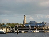
in 1991. "Old Baldy
", its out-of-service lighthouse
, is the oldest still standing in the state, built in 1817. It is part of the Wilmington Metropolitan Statistical Area.
Construction of the original light was completed in December 1794 at a final cost of $11,359,14. The light was placed under the care of lightkeeper, Henry Long who operated the light until 1806 when he was killed in a hunting accident on the island.
Less than twenty years after it was built, the original light succumbed to erosion as it had been built too close to the water. By July, 1813 the light was officially declared inoperable.
Immediately after lighting Old Baldy it was discovered that the light was neither tall enough nor bright enough to help vessels navigate around Frying Pan Shoals. Its purpose was limited to helping vessels enter the southern entrance to the Cape Fear River. To avoid Frying Pan Shoals
, many vessels decided to enter the Cape Fear through New Inlet at Fort Fisher
, about seven miles north of Bald Head Island. As a result, little emphasis was placed on maintaining the Old Baldy and it fell into disrepair under its revolutionary veteran lightkeeper.
Old Baldy Lighthouse was effectively decommissioned for the first time at the outset of the American Civil War
when the Confederate States
turned off all their lighthouses in order to hinder navigation of Union
vessels. At the end of the war Old Baldy was not re-lit. The light was in disrepair and of little use with most vessels entering New Inlet, which had its own lighthouse at Federal Point.
Circumstances changed by 1879 when natural forces closed New Inlet forcing the closure of the Federal Point light and the re-lighting of Old Baldy. Improvements were made to Old Bald including a new light, keepers quarters, and a stone jetty to stabilize the shoreline which had begun eroding quickly due to the closure of New Inlet. According to reports, the jetty was built just in time to prevent Old Baldy from falling into the sea during the hurricane of September 1883.
Old Baldy was downgraded from a lighthouse to a navigational radio beacon in 1935. It was completely decommissioned in 1959 when the Oak Island Light was built. Old Baldy Lighthouse now stands as the oldest lighthouse in North Carolina
, having survived neglect, war and weather. It is on the Register Historic Places and is open to the public.
due to its restricted height and brightness. To patch the problem, a lightship was stationed on the shoals themselves in the mid 1800s. On multiple occasions the lightship broke loose and drifted freely, leaving Frying Pan Shoals
without a light, or worse with a light in the wrong place. This problem was compounded when New Inlet closed and vessels were no longer able to avoid navigating around the shoals.
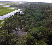
Proposals for construction of a second lighthouse on Bald Head Island started in 1889 with the suggestion that a 150 ft tall, 18.5 mi visibility, masonry tower be built at a cost of $150,000. Approval did not come until 1898, at which time it was suggested that a steel tower be built for $70,000. Land for the construction site on the east end of Bald Head Island had to be condemned by the state from the island's owner. Construction began in 1901 by laying a railway from the west end of the island to the east. This railway would transport materials and supplies over three miles to the site both during construction and operation. The Cape Fear Light was operational on August 31, 1903. The light was operated by Devaney F. Jennette and then by Capt. Charlie Swan.
In 1958, the Cape Fear Light was demolished and replaced by the Oak Island Light. Lightships
and a light tower
were used to augment navigation around Frying Pan Shoals
through the 1970s.
According to the United States Census Bureau
, the village has a total area of 5.8 square miles (15 km²), with 4.3 square miles (11.1 km²) of it being land and 1.5 square miles (3.9 km²) of it (25.73%) is water.
Since Hurricane Floyd
in 1999, Bald Head Island is no longer a distinct island, but is connected along the shore by shoal with the Fort Fisher State Recreation Area
to Pleasure Island
. Like Pea Island after the inlet separating it from Hatteras Island
closed, the two joined areas have maintained their historical names.
There are three beaches on the island, as the north side consists of marsh.
 As of the census
of 2000, there were 173 people, 88 households, and 71 families residing in the village. The population density
was 40.3 people per square mile (15.6/km²). There were 599 housing units at an average density of 139.5 per square mile (53.9/km²). The racial makeup of the village was 95.38% White, 2.89% African American, 0.58% Native American, and 1.16% from two or more races.
There were 88 households out of which 5.7% had children under the age of 18 living with them, 77.3% were married couples
living together, 3.4% had a female householder with no husband present, and 19.3% were non-families. 18.2% of all households were made up of individuals and 3.4% had someone living alone who was 65 years of age or older. The average household size was 1.97 and the average family size was 2.17.
In the village the population was spread out with 5.8% under the age of 18, 1.2% from 18 to 24, 11.0% from 25 to 44, 63.6% from 45 to 64, and 18.5% who were 65 years of age or older. The median age was 56 years. For every 100 females there were 106.0 males. For every 100 females age 18 and over, there were 101.2 males.
The median income for a household in the village was $62,083, and the median income for a family was $56,964. Males had a median income of $51,250 versus $35,000 for females. The per capita income
for the village was $45,585. About 10.8% of families and 10.3% of the population were below the poverty line, including 40.0% of those under the age of eighteen and none of those sixty five or over.
Bald Head InsiderInfo Area Guide
Cape Fear River
The Cape Fear River is a long blackwater river in east central North Carolina in the United States. It flows into the Atlantic Ocean near Cape Fear, from which it takes its name. The overall water quality of the river is continuously measured and monitored by and conducted by the , , and the...
in Brunswick County
Brunswick County, North Carolina
-External links:*******....
, North Carolina
North Carolina
North Carolina is a state located in the southeastern United States. The state borders South Carolina and Georgia to the south, Tennessee to the west and Virginia to the north. North Carolina contains 100 counties. Its capital is Raleigh, and its largest city is Charlotte...
, United States
United States
The United States of America is a federal constitutional republic comprising fifty states and a federal district...
. Compared to the city of Wilmington
Wilmington, North Carolina
Wilmington is a port city in and is the county seat of New Hanover County, North Carolina, United States. The population is 106,476 according to the 2010 Census, making it the eighth most populous city in the state of North Carolina...
to the north, the village of Bald Head Island is small and somewhat remote. It is only accessible by ferry
Ferry
A ferry is a form of transportation, usually a boat, but sometimes a ship, used to carry primarily passengers, and sometimes vehicles and cargo as well, across a body of water. Most ferries operate on regular, frequent, return services...
from the nearby town of Southport
Southport, North Carolina
Southport is a city in Brunswick County, North Carolina, near the mouth of the Cape Fear River. It is part of the Wilmington Metropolitan Statistical Area...
. Cars are not allowed; instead residents drive modified electric
Electric vehicle
An electric vehicle , also referred to as an electric drive vehicle, uses one or more electric motors or traction motors for propulsion...
golf carts.
The village is revered for its picturesque
Picturesque
Picturesque is an aesthetic ideal introduced into English cultural debate in 1782 by William Gilpin in Observations on the River Wye, and Several Parts of South Wales, etc. Relative Chiefly to Picturesque Beauty; made in the Summer of the Year 1770, a practical book which instructed England's...
nature and is a popular location for retirement
Retirement
Retirement is the point where a person stops employment completely. A person may also semi-retire by reducing work hours.Many people choose to retire when they are eligible for private or public pension benefits, although some are forced to retire when physical conditions don't allow the person to...
. It was the primary filming location for the successful film
Film
A film, also called a movie or motion picture, is a series of still or moving images. It is produced by recording photographic images with cameras, or by creating images using animation techniques or visual effects...
Weekend at Bernie's
Weekend at Bernie's
Weekend at Bernie's is a 1989 American comedy film directed by Ted Kotcheff. A comedy starring Andrew McCarthy and Jonathan Silverman features the two as a couple of young insurance agency employees who discover their boss is deceased...
in 1989, as well as being a major location in The Butcher's Wife
The Butcher's Wife
The Butcher's Wife is a 1991 romantic comedy film, in which a clairvoyant woman thinks that she's met her future husband , who she has seen in her dreams and is a butcher in New York. They marry and move to the city, where her powers tend to influence everyone she meets while working in the shop...
in 1991. "Old Baldy
Bald Head lighthouse
Bald Head Lighthouse, known as Old Baldy, is the oldest lighthouse still standing in North Carolina. It is the second of three lighthouses that have been built on Bald Head Island since the 18th century to help guide ships past the dangerous shoals at the mouth of the Cape Fear river.-History:A...
", its out-of-service lighthouse
Lighthouse
A lighthouse is a tower, building, or other type of structure designed to emit light from a system of lamps and lenses or, in older times, from a fire, and used as an aid to navigation for maritime pilots at sea or on inland waterways....
, is the oldest still standing in the state, built in 1817. It is part of the Wilmington Metropolitan Statistical Area.
History
Bald Head Island is tiny but has played a part in two American wars. During the American Revolution, it was home to Fort George, a British fort. During the Civil War, the same redoubts served as Fort Holmes, a Confederate base of importance to shipping and smuggling.Natural history
Located at the tip of Cape Fear and residing at the convergence of the Cape Fear River and Atlantic Gulf Stream, the land mass of Bald Head Island ends, trailing off into thirty miles of treacherous sand bars known as Frying Pan Shoals. In this area, large sand bars seasonally emerge from and subsequently retreat into the sea. These topographical transformations are often as rapid as they are drastic. The consensus view is that Bald Head Island emerged from one such sandbar, stabilized by a succession of plant life, leading to a permanent land mass.Native Americans
Author David Stick surmises that Native Americans used Bald Head Island in much the same way that it is used now, as a seasonal retreat. Bald Head Island's creek estuaries and its abundance of shellfish were probably as attractive to Native American fishermen as they are to modern fishermen. Shellmounds found on Middle Island and Bluff Island, indicate that Native Americans did visit the Smith Island complex but disease and war killed off most of the Native American population, so it is difficult to know much about the original inhabitants.European settlement
Throughout the early European history of the Cape Fear region, Bald Head Island underwent several settlement attempts and went by many names. Unlike the specific landmarks which were re-named by each settler, the region was always known by the well-earned name, "Cape Fear".Pedro de Quexos
Though Spanish sailors probably frequented the island on their way to intercept the Gulf Stream off Cape Hatteras, Pedro de Quexos was the first documented explorer of the region in the 1520s, naming the river the "River Jordan". Quexos' sponsor, Lucas Vasques de Ayllon, visited the region himself in 1526. When Ayllon lost a ship to the treacherous shoals he abandoned his exploration efforts.William Hilton
Over one hundred years after Quexos, William Hilton initiated an expedition called the "Adventures about Cape Fayre" by English Puritan dissidents in the 1660s. The effort was abandoned due to difficulties farming the sandy barren soil. Hilton returned in 1667 with the support of backers from Barbados, the "Barbados Adventurers", aboard a ship, the "Adventure" (now the name of one of the Bald Head Island ferries). His efforts were again foiled by barren soil.John Vassal and John Yeamans
In 1664, John Vassal founded "Charles Town" with the aid of Barbadian backers on the west bank of what is now the Cape Fear river (which Vassal named the "Charles River"). His efforts failed due to his agitation of the native population. He was further dissuaded when and his efforts to become governor of the region, Clarendon County, where subverted and the title was given to John Yeamans. After the settlers abandoned Charles Town and Yeamans nearly lost his life when his boat sank in a maze of sand bars in the mouth of the Charles River. Instead of trying to revive the colony, Yeamans established Charles Town farther south in what is now Charleston, South Carolina.Thomas Smith
Charleston rapidly became a center of economic importance in the colonies. Charleston business men often engaged in trade with Native Americans in the vicinity of Cape Fear reaping such prosperity that they had to pay special duties. Duties created political conflicts which ultimately led to the colony of the Carolinas being divided in 1710 along the Cape Fear river (named the "Clarendon River" by then). In 1713, to help establish the northern colony's claim along the eastern bank, Thomas Smith, son of former Carolina governor Thomas Smith, Sr. was issued a land grant to what we now call Smith Island (called "Cape Island" at the time).Revolutionary War
In 1776, Bald Head Island was briefly involved in the Revolutionary War after British Major General Henry Clinton and Lieutenant Charles Cornwallis (later promoted to general) used the island as a staging area for their voyage to Charleston, SC. The British left behind a small garrison of troops with a few naval vessels to help keep the port closed to Continental shipping. The garrison of about thirty troops, under the command of Captain John Linzee, created Fort George (after King George) on the southwestern corner of Bald Head Island. Continental Brig. General Robert Howe was stationed across the river in Fort Johnson. After watching the British carefully, the Continentals launched a raid of one hundred fifty men on September 6, led by Col. Polk, against Fort George. Polks men captured five British sailors but were forced to flee when the remaining twenty-five took cover and the British vessels moored just off-shore opened fire and initiated pursuit. Polk used local knowledge, fleeing through a maze of shallow creeks and escaped with only minor casualties (1 killed, 1 wounded). By October, the British troops withdrew and Bald Head saw no further action during the Revolution.Original lighthouse
The construction of a lighthouse at the mouth of the Cape Fear river was authorized by the Commissioners of the Cape Fear in 1789. The commission specified that the light be built "at the extreme point on Bald-head or some other convenient place near the bar of said river, in order that vessels may be enabled thereby to avoid the great shoal called Frying-Pan." Funds had been raised for the implementation of navigation aids by taxing vessels entering The Port of Brunswick at six pence per ton. Additional funds were provided by the newly formed US Congress who, in August of 1789, assumed responsibility for construction, maintenance and operation of all "lighthouses, beacons, buoys and public piers" in the US. Land for the light was donated by Benjamin Smith in exchange for increased hunting regulation on the island.Construction of the original light was completed in December 1794 at a final cost of $11,359,14. The light was placed under the care of lightkeeper, Henry Long who operated the light until 1806 when he was killed in a hunting accident on the island.
Less than twenty years after it was built, the original light succumbed to erosion as it had been built too close to the water. By July, 1813 the light was officially declared inoperable.
Old Baldy
In 1813 Congress allocated $15,000 to build a new lighthouse on Bald Head as the existing light had been rendered inoperable by erosion. This time they planned to build a sturdy lighthouse on high-ground, away from eroding shores. Revenue Commissioner Samuel H. Smith wrote an extremely detailed specification outlining how the light was to be built to ensure the longevity. Daniel Way was awarded the contract to build the light and keepers quarters. Using bricks from the original light, Way completed the project in 1817 at a cost of $15,915.45.Immediately after lighting Old Baldy it was discovered that the light was neither tall enough nor bright enough to help vessels navigate around Frying Pan Shoals. Its purpose was limited to helping vessels enter the southern entrance to the Cape Fear River. To avoid Frying Pan Shoals
Frying Pan Shoals
The Frying Pan Shoals are a long, shifting area of shoals off the coast of Cape Fear in North Carolina, United States. The shoals have been a hazard to ships in the area since the beginning of European exploration of the area; the area is littered with shipwrecks. The southern edge of the shoals...
, many vessels decided to enter the Cape Fear through New Inlet at Fort Fisher
Fort Fisher
Fort Fisher was a Confederate fort during the American Civil War. It protected the vital trading routes of the port at Wilmington, North Carolina, from 1861 until its capture by the Union in 1865....
, about seven miles north of Bald Head Island. As a result, little emphasis was placed on maintaining the Old Baldy and it fell into disrepair under its revolutionary veteran lightkeeper.
Old Baldy Lighthouse was effectively decommissioned for the first time at the outset of the American Civil War
American Civil War
The American Civil War was a civil war fought in the United States of America. In response to the election of Abraham Lincoln as President of the United States, 11 southern slave states declared their secession from the United States and formed the Confederate States of America ; the other 25...
when the Confederate States
Confederate States of America
The Confederate States of America was a government set up from 1861 to 1865 by 11 Southern slave states of the United States of America that had declared their secession from the U.S...
turned off all their lighthouses in order to hinder navigation of Union
Union (American Civil War)
During the American Civil War, the Union was a name used to refer to the federal government of the United States, which was supported by the twenty free states and five border slave states. It was opposed by 11 southern slave states that had declared a secession to join together to form the...
vessels. At the end of the war Old Baldy was not re-lit. The light was in disrepair and of little use with most vessels entering New Inlet, which had its own lighthouse at Federal Point.
Circumstances changed by 1879 when natural forces closed New Inlet forcing the closure of the Federal Point light and the re-lighting of Old Baldy. Improvements were made to Old Bald including a new light, keepers quarters, and a stone jetty to stabilize the shoreline which had begun eroding quickly due to the closure of New Inlet. According to reports, the jetty was built just in time to prevent Old Baldy from falling into the sea during the hurricane of September 1883.
Old Baldy was downgraded from a lighthouse to a navigational radio beacon in 1935. It was completely decommissioned in 1959 when the Oak Island Light was built. Old Baldy Lighthouse now stands as the oldest lighthouse in North Carolina
North Carolina
North Carolina is a state located in the southeastern United States. The state borders South Carolina and Georgia to the south, Tennessee to the west and Virginia to the north. North Carolina contains 100 counties. Its capital is Raleigh, and its largest city is Charlotte...
, having survived neglect, war and weather. It is on the Register Historic Places and is open to the public.
Cape Fear Light
Old Baldy lighthouse, built in 1817, failed to aid vessels trying to avoid Frying Pan ShoalsFrying Pan Shoals
The Frying Pan Shoals are a long, shifting area of shoals off the coast of Cape Fear in North Carolina, United States. The shoals have been a hazard to ships in the area since the beginning of European exploration of the area; the area is littered with shipwrecks. The southern edge of the shoals...
due to its restricted height and brightness. To patch the problem, a lightship was stationed on the shoals themselves in the mid 1800s. On multiple occasions the lightship broke loose and drifted freely, leaving Frying Pan Shoals
Frying Pan Shoals
The Frying Pan Shoals are a long, shifting area of shoals off the coast of Cape Fear in North Carolina, United States. The shoals have been a hazard to ships in the area since the beginning of European exploration of the area; the area is littered with shipwrecks. The southern edge of the shoals...
without a light, or worse with a light in the wrong place. This problem was compounded when New Inlet closed and vessels were no longer able to avoid navigating around the shoals.
Proposals for construction of a second lighthouse on Bald Head Island started in 1889 with the suggestion that a 150 ft tall, 18.5 mi visibility, masonry tower be built at a cost of $150,000. Approval did not come until 1898, at which time it was suggested that a steel tower be built for $70,000. Land for the construction site on the east end of Bald Head Island had to be condemned by the state from the island's owner. Construction began in 1901 by laying a railway from the west end of the island to the east. This railway would transport materials and supplies over three miles to the site both during construction and operation. The Cape Fear Light was operational on August 31, 1903. The light was operated by Devaney F. Jennette and then by Capt. Charlie Swan.
In 1958, the Cape Fear Light was demolished and replaced by the Oak Island Light. Lightships
Frying Pan (lightship)
Frying Pan is a lightvessel moored at Pier 66a in the Chelsea neighborhood of Manhattan in New York City. It served at Frying Pan Shoals, off Cape Fear in North Carolina, for over 30 years.-Frying Pan Shoals Station:...
and a light tower
Frying Pan Shoals Light
Frying Pan Shoals Light Tower is a decommissioned lighthouse located approximately southeast of Southport, North Carolina.The light tower is modeled after a steel oil drilling platform, known as a “Texas Tower” on top of four...
were used to augment navigation around Frying Pan Shoals
Frying Pan Shoals
The Frying Pan Shoals are a long, shifting area of shoals off the coast of Cape Fear in North Carolina, United States. The shoals have been a hazard to ships in the area since the beginning of European exploration of the area; the area is littered with shipwrecks. The southern edge of the shoals...
through the 1970s.
Geography
Bald Head Island is located at 33°51′43"N 77°59′24"W (33.861876, -77.990138).According to the United States Census Bureau
United States Census Bureau
The United States Census Bureau is the government agency that is responsible for the United States Census. It also gathers other national demographic and economic data...
, the village has a total area of 5.8 square miles (15 km²), with 4.3 square miles (11.1 km²) of it being land and 1.5 square miles (3.9 km²) of it (25.73%) is water.
Since Hurricane Floyd
Hurricane Floyd
Hurricane Floyd was the sixth named storm, fourth hurricane, and third major hurricane in the 1999 Atlantic hurricane season. Floyd triggered the third largest evacuation in US history when 2.6 million coastal residents of five states were ordered from their homes as it approached...
in 1999, Bald Head Island is no longer a distinct island, but is connected along the shore by shoal with the Fort Fisher State Recreation Area
Fort Fisher State Recreation Area
Fort Fisher State Recreation Area is a North Carolina state park in New Hanover County, North Carolina in the United States. Located near Kure Beach, North Carolina, it includes Fort Fisher, site of a major naval engagement during the American Civil War. The recreation area also served as a home...
to Pleasure Island
Pleasure Island (North Carolina)
Pleasure Island is a coastal island in Southeastern North Carolina, USA south of Wilmington. The coastal towns of Carolina Beach and Kure Beach, as well as the annexed community of Wilmington Beach, are located on the island...
. Like Pea Island after the inlet separating it from Hatteras Island
Hatteras Island
Hatteras Island is a barrier island located off the North Carolina coast. Dividing the Atlantic Ocean and the Pamlico Sound, it runs parallel to the coast, forming a bend at Cape Hatteras. It is part of North Carolina's Outer Banks and includes the towns of Rodanthe, Waves, Salvo, Avon, Buxton,...
closed, the two joined areas have maintained their historical names.
There are three beaches on the island, as the north side consists of marsh.
Demographics
Census
A census is the procedure of systematically acquiring and recording information about the members of a given population. It is a regularly occurring and official count of a particular population. The term is used mostly in connection with national population and housing censuses; other common...
of 2000, there were 173 people, 88 households, and 71 families residing in the village. The population density
Population density
Population density is a measurement of population per unit area or unit volume. It is frequently applied to living organisms, and particularly to humans...
was 40.3 people per square mile (15.6/km²). There were 599 housing units at an average density of 139.5 per square mile (53.9/km²). The racial makeup of the village was 95.38% White, 2.89% African American, 0.58% Native American, and 1.16% from two or more races.
There were 88 households out of which 5.7% had children under the age of 18 living with them, 77.3% were married couples
Marriage
Marriage is a social union or legal contract between people that creates kinship. It is an institution in which interpersonal relationships, usually intimate and sexual, are acknowledged in a variety of ways, depending on the culture or subculture in which it is found...
living together, 3.4% had a female householder with no husband present, and 19.3% were non-families. 18.2% of all households were made up of individuals and 3.4% had someone living alone who was 65 years of age or older. The average household size was 1.97 and the average family size was 2.17.
In the village the population was spread out with 5.8% under the age of 18, 1.2% from 18 to 24, 11.0% from 25 to 44, 63.6% from 45 to 64, and 18.5% who were 65 years of age or older. The median age was 56 years. For every 100 females there were 106.0 males. For every 100 females age 18 and over, there were 101.2 males.
The median income for a household in the village was $62,083, and the median income for a family was $56,964. Males had a median income of $51,250 versus $35,000 for females. The per capita income
Per capita income
Per capita income or income per person is a measure of mean income within an economic aggregate, such as a country or city. It is calculated by taking a measure of all sources of income in the aggregate and dividing it by the total population...
for the village was $45,585. About 10.8% of families and 10.3% of the population were below the poverty line, including 40.0% of those under the age of eighteen and none of those sixty five or over.
Climate
The island has a humid subtropical climate, with hot, humid summers and cool winters.External Links
Official WebsiteBald Head InsiderInfo Area Guide