
Crewe and Nantwich Circular Walk
Encyclopedia

Cheshire East
Cheshire East is a unitary authority area with borough status in the ceremonial county of Cheshire, England.The borough was established in April 2009 as part of the 2009 structural changes to local government in England, by virtue of an order under the Local Government and Public Involvement in...
area of Cheshire
Cheshire
Cheshire is a ceremonial county in North West England. Cheshire's county town is the city of Chester, although its largest town is Warrington. Other major towns include Widnes, Congleton, Crewe, Ellesmere Port, Runcorn, Macclesfield, Winsford, Northwich, and Wilmslow...
, England
England
England is a country that is part of the United Kingdom. It shares land borders with Scotland to the north and Wales to the west; the Irish Sea is to the north west, the Celtic Sea to the south west, with the North Sea to the east and the English Channel to the south separating it from continental...
. As the name suggests, the walk forms a circuit around the towns of Crewe
Crewe
Crewe is a railway town within the unitary authority area of Cheshire East and the ceremonial county of Cheshire, England. According to the 2001 census the urban area had a population of 67,683...
and Nantwich
Nantwich
Nantwich is a market town and civil parish in the Borough of Cheshire East and the ceremonial county of Cheshire, England. The town gives its name to the parliamentary constituency of Crewe and Nantwich...
. It is one of two circular walks in the county of Cheshire, the other being the Vale Royal Round.
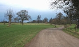
The walk is waymarked with a circle with symbols of a leaf, cartwheel and crossed swords. Although mainly on level terrain, the many stiles make the walk unsuitable for people with mobility problems.
Route and sights of interest

Weston to Acton
10 miles (16.1 km)- WestonWeston, CheshireWeston is a village and civil parish in the unitary authority of Cheshire East and the ceremonial county of Cheshire, England. The village lies 3 miles to the south east of Crewe. The parish also includes the small settlements of Carters Green, Gorsthill, Rose Hill, Snape, Stowford and part of...
- Hough CommonHough, CheshireHough is a village and civil parish in the unitary authority of Cheshire East and the ceremonial county of Cheshire, England. The village is located 3 miles to the south of Crewe and 4 miles to the east of Nantwich. The parish also includes part of the settlement of Goodalls Corner. The total...
- WybunburyWybunburyWybunbury is a village and civil parish in the unitary authority of Cheshire East and the ceremonial county of Cheshire, England. The village lies 3¼ miles to the south east of Nantwich and 3¾ miles to the south of Crewe. The parish also includes the settlements of Clannor Heath, Daisy Hill, The...
- Mill Bank Farm, with site of medieval watermill
- Old Hall AustersonOld Hall AustersonAusterson is a civil parish in the unitary authority of Cheshire East and the ceremonial county of Cheshire, England, lying immediately south of the town of Nantwich and north of the village of Audlem. Predominantly rural with scattered farms, the civil parish includes the small settlement of Old...
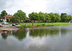
, with 16th-century barn - Shrewbridge Lake, saltwater lake on the outskirts of NantwichNantwichNantwich is a market town and civil parish in the Borough of Cheshire East and the ceremonial county of Cheshire, England. The town gives its name to the parliamentary constituency of Crewe and Nantwich...
- Dorfold HallDorfold HallDorfold Hall is a Jacobean mansion in Acton, near Nantwich, in Cheshire, UK. It is listed at grade I. It was considered by Nikolaus Pevsner to be one of the two finest Jacobean houses in Cheshire.The present owners are the Roundells.-History:...
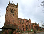
, Jacobean manor house - St Mary's Church, ActonSt Mary's Church, ActonSt Mary's Church, Acton is an active Anglican church in Acton, a village to the west of Nantwich, Cheshire, England. It has been designated by English Heritage as a Grade I listed building. A church has been present on this site since before the time of the Domesday Survey. The tower is the...
, with tower dating from the 13th century. The churchyard has a 17th-century sundial and almhouses dating from 1613. - ActonActon, CheshireActon is a small village and civil parish lying immediately west of the town of Nantwich in the unitary authority of Cheshire East and the ceremonial county of...
village has several buildings dating from the 17th and 18th centuries
Acton to Coppenhall
10.5 miles (17 km)- HenhullHenhullHenhull is a civil parish in the unitary authority of Cheshire East and the ceremonial county of Cheshire, England, which lies to the north west of Nantwich. For administrative purposes, it is combined with adjacent civil parishes of Acton and Edleston to form a total area of 765 hectares...
, site of Roman road - Reaseheath CollegeReaseheath CollegeReaseheath College is a land-based further education college, mainly located in the village of Worleston in Cheshire, England. It opened in 1921....
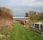
- Middlewich branch of the Shropshire Union CanalShropshire Union CanalThe Shropshire Union Canal is a navigable canal in England; the Llangollen and Montgomery canals are the modern names of branches of the Shropshire Union system and lie partially in Wales....
, with Brickyard Bridge, named after an adjacent brickworks - Moat House Farm, with remains of unusual old moat structure
Coppenhall to Weston
8.5 miles (14 km)- Coppenhall MossCoppenhallCoppenhall is a small settlement in Staffordshire, England. Coppenhall lies southwest of Stafford and NNW of Penkridge with Baron Stafford as lord of the manor. The parish of ~ is bounded on the east by the Pothooks Brook...
, site of former peat bog, now drained - Sandbach FlashesSandbach FlashesSandbach Flashes is a wetland west of Sandbach in Cheshire, England. The flashes were designated as a Site of Special Scientific Interest in 1963, with a total area of 1.53 km²...
, series of salt water pools, good for bird-watching - Winterley, former millpond, now home to mute swans
- Haslington HallHaslingtonHaslington is a village and civil parish in the unitary authority of Cheshire East and the ceremonial county of Cheshire, England. It lies about 2 miles north-east of the much larger railway town of Crewe and approximately 4 miles south of Sandbach...
, Tudor house - Valley Brook, surrounded by old woodland