Ravensmoor
Encyclopedia
Ravensmoor is a village in the unitary authority of Cheshire East
and the ceremonial county of Cheshire
, England, located at . It is split between the civil parish
es of Baddiley
and Burland
. It lies at an elevation of 65 m, around 2¼ miles south west of Nantwich
and 6 miles south west of Crewe
.
The village centres around the crossroads of Baddiley Lane, Marsh Lane, Swanley Lane and Sound Lane, with a small village green adjacent. Much of the village dates from the second half of the 20th century.
The village lies within a fork of the Shropshire Union Canal
south of the Hurleston
Junction; the Llangollen branch
runs ⅔ miles to the west and the main line of the canal runs just over a mile to the east. Ravensmoor Brook runs to the east of the village and Edleston Brook to the south and west.
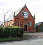
 The Baddiley and Ravensmoor Methodist Church, formerly a Wesleyan Chapel, is located on Swanley Lane in the north west of the village (at ). Dated 1878, the building is in orange brick with stone dressing and has a prominent circular window and pillars capped with decorative stonework.
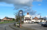
The Farmer's Arms public house stands at the crossroads.
Cheshire East
Cheshire East is a unitary authority area with borough status in the ceremonial county of Cheshire, England.The borough was established in April 2009 as part of the 2009 structural changes to local government in England, by virtue of an order under the Local Government and Public Involvement in...
and the ceremonial county of Cheshire
Cheshire
Cheshire is a ceremonial county in North West England. Cheshire's county town is the city of Chester, although its largest town is Warrington. Other major towns include Widnes, Congleton, Crewe, Ellesmere Port, Runcorn, Macclesfield, Winsford, Northwich, and Wilmslow...
, England, located at . It is split between the civil parish
Civil parish
In England, a civil parish is a territorial designation and, where they are found, the lowest tier of local government below districts and counties...
es of Baddiley
Baddiley
Baddiley is a scattered settlement and civil parish in the unitary authority of Cheshire East and the ceremonial county of Cheshire, England. The civil parish also includes the north-western part of the village of Ravensmoor , as well as the small settlements of Baddiley Hulse, Batterley Hill, and...
and Burland
Burland
Burland is a village and civil parish in the unitary authority of Cheshire East and the ceremonial county of Cheshire, England, about 2½ miles west of Nantwich. The civil parish also includes the small settlements of Burland Lower Green, Burland Upper Green, Hollin Green and Stoneley Green, as well...
. It lies at an elevation of 65 m, around 2¼ miles south west of Nantwich
Nantwich
Nantwich is a market town and civil parish in the Borough of Cheshire East and the ceremonial county of Cheshire, England. The town gives its name to the parliamentary constituency of Crewe and Nantwich...
and 6 miles south west of Crewe
Crewe
Crewe is a railway town within the unitary authority area of Cheshire East and the ceremonial county of Cheshire, England. According to the 2001 census the urban area had a population of 67,683...
.
The village centres around the crossroads of Baddiley Lane, Marsh Lane, Swanley Lane and Sound Lane, with a small village green adjacent. Much of the village dates from the second half of the 20th century.
The village lies within a fork of the Shropshire Union Canal
Shropshire Union Canal
The Shropshire Union Canal is a navigable canal in England; the Llangollen and Montgomery canals are the modern names of branches of the Shropshire Union system and lie partially in Wales....
south of the Hurleston
Hurleston
Hurleston is a civil parish in the unitary authority of Cheshire East and the ceremonial county of Cheshire, England, which lies to the north west of Nantwich. The parish is predominantly rural with scattered farms and buildings and no settlements...
Junction; the Llangollen branch
Llangollen Canal
The Llangollen Canal is a navigable canal crossing the border between England and Wales. The waterway links Llangollen in Denbighshire, north Wales, with Hurleston in south Cheshire, via the town of Ellesmere, Shropshire....
runs ⅔ miles to the west and the main line of the canal runs just over a mile to the east. Ravensmoor Brook runs to the east of the village and Edleston Brook to the south and west.
Notable buildings

The Farmer's Arms public house stands at the crossroads.

