
Heathcote River
Encyclopedia
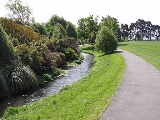
The Heathcote River lies within the city boundaries of Christchurch
, New Zealand
, and is fed from springs near Templetons Road and also receives wet weather flows from as far west as Pound Road. It meanders around the base of the Port Hills
from west to south-east.
, Hillmorton (where the main springs are located), Hoon Hay
, Spreydon
, Cracroft, Cashmere
, Beckenham
, St Martins
, Woolston
and Ferrymead
.
It drains into the Avon Heathcote Estuary
before draining into Pegasus Bay
.
', or 'The Outpost' and refers to this pā being an outpost (Māori: waho) of Kaiapoi
. The pā was built in a higher location just downstream of the present Opawa Road Bridge. It was a resting place for Ngāi Tahu
travelling between Kaiapoi
and Horomaka
(Banks Peninsula). The surrounding area was an important mahinga kai, a source of plentiful food, especially tuere
(blind eel) and kanakana (lamprey).
The river historically meandered through extensive wetland
s prior to urbanisation. Historic survey maps from the mid-19th century (the so-called 'Black Maps') indicate that the habitat that the river passed through was abundant in flax
(harakeke), toetoe
, raupo, tutu
and fern
s and was dotted with ti kouka (cabbage tree).
The river corridor was low-lying and very wet. When the Waimakariri River
rose and flowed across the plains, even higher ground was prone to flooding. Over many centuries of using the river as a food source and transport corridor, the iwi
of Waitaha
, Kāti Mamoe
and Ngāi Tahu fostered a close relationship with this resource. The swamp forest around the river provided gathering grounds for water fowl and forest birds. Traps were regularly set for inanga (whitebait), pātiki
(flounder), and tuna
(eel).
The Heathcote River is named after Sir William Heathcote, secretary of the Canterbury Association
.

Christchurch
Christchurch is the largest city in the South Island of New Zealand, and the country's second-largest urban area after Auckland. It lies one third of the way down the South Island's east coast, just north of Banks Peninsula which itself, since 2006, lies within the formal limits of...
, New Zealand
New Zealand
New Zealand is an island country in the south-western Pacific Ocean comprising two main landmasses and numerous smaller islands. The country is situated some east of Australia across the Tasman Sea, and roughly south of the Pacific island nations of New Caledonia, Fiji, and Tonga...
, and is fed from springs near Templetons Road and also receives wet weather flows from as far west as Pound Road. It meanders around the base of the Port Hills
Port Hills
The Port Hills form the northern rim of the ancient Lyttelton volcano, separating the port of Lyttelton from the city of Christchurch in Canterbury, New Zealand...
from west to south-east.
Course
The catchment of the Heathcote River extends to the suburb of Yaldhurst. It flows through WigramWigram
Wigram is a suburb of Christchurch, New Zealand. Technically called Wigram Park, the second half of its name is rarely if ever heard. The suburb lies close to the industrial estates of Sockburn and the satellite retail and residential zone of Hornby...
, Hillmorton (where the main springs are located), Hoon Hay
Hoon Hay
Hoon Hay is an outer suburb of Christchurch, New Zealand. It lies to the southwest of the city close to the Port Hills. It is named after a village in Derbyshire....
, Spreydon
Spreydon
Spreydon is a middle-class suburb of Christchurch, New Zealand. The most central street through Spreydon is Lyttelton Street. Spreydon is flanked by the suburbs Barrington, Hoon Hay, Riccarton, and Lower Cashmere....
, Cracroft, Cashmere
Cashmere, New Zealand
The suburb of Cashmere rises above the southern end of the city of Christchurch in New Zealand’s South Island.-Geography:Cashmere is situated on the north side of the Port Hills, immediately above the southern terminus of Christchurch’s main street, Colombo Street...
, Beckenham
Beckenham, New Zealand
Beckenham is an inner suburb of Christchurch, New Zealand, located three kilometres south of the city centre. The Heathcote River winds through this predominantly residential suburb, a section of which is often referred to locally as the "Beckenham Loop"....
, St Martins
St Martins, New Zealand
St Martins is an inner suburb of Christchurch, New Zealand, located two kilometres south of the city centre. Primarily a residential area, St Martins was until recently host to a small shopping mall complex situated on Wilsons Road, the main thoroughfare through the suburb...
, Woolston
Woolston, New Zealand
Woolston is a light industrial and residential suburb of Christchurch in the South Island of New Zealand. It is situated three kilometres southeast of the city centre, close to major arterial routes including State Highways 73 and 74 to Banks Peninsula...
and Ferrymead
Ferrymead
-Geography:Ferrymead is located on the Avon Heathcote Estuary, close to the point where the Heathcote River drains into the estuary, and three km west of the eventual outflow into Pegasus Bay. To the north lie the oxidation ponds from Christchurch's main sewage treatment works, which are within a...
.
It drains into the Avon Heathcote Estuary
Avon Heathcote Estuary
The Avon Heathcote Estuary is the largest semi-enclosed shallow estuary in Canterbury and remains one of New Zealand’s most important coastal wetlands. It is well known as an internationally important habitat for migratory birds, and it is an important recreational playground and educational resource...
before draining into Pegasus Bay
Pegasus Bay
Pegasus Bay is on the east coast of the South Island of New Zealand.-Location:The bay has a sandy beach and runs from Banks Peninsula to the Waipara River mouth...
.
Pre-European settlement and naming
The original name of this river, Ō-pa-waho means 'The Place of the Outward PāPa (Maori)
The word pā can refer to any Māori village or settlement, but in traditional use it referred to hillforts fortified with palisades and defensive terraces and also to fortified villages. They first came into being about 1450. They are located mainly in the North Island north of lake Taupo...
', or 'The Outpost' and refers to this pā being an outpost (Māori: waho) of Kaiapoi
Kaiapoi
Kaiapoi is a town in the Canterbury region of the South Island of New Zealand, located close to the mouth of the Waimakariri River, and approximately 17 kilometres north of Christchurch....
. The pā was built in a higher location just downstream of the present Opawa Road Bridge. It was a resting place for Ngāi Tahu
Ngāi Tahu
Ngāi Tahu, or Kāi Tahu, is the principal Māori iwi of the southern region of New Zealand, with the tribal authority, Te Rūnanga o Ngāi Tahu, being based in Christchurch and Invercargill. The iwi combines three groups, Kāi Tahu itself, and Waitaha and Kāti Mamoe who lived in the South Island prior...
travelling between Kaiapoi
Kaiapoi
Kaiapoi is a town in the Canterbury region of the South Island of New Zealand, located close to the mouth of the Waimakariri River, and approximately 17 kilometres north of Christchurch....
and Horomaka
Banks Peninsula
Banks Peninsula is a peninsula of volcanic origin on the east coast of the South Island of New Zealand. It has an area of approximately and encompasses two large harbours and many smaller bays and coves...
(Banks Peninsula). The surrounding area was an important mahinga kai, a source of plentiful food, especially tuere
New Zealand hagfish
The New Zealand hagfish, or Broadgilled Hagfish, , is a hagfish of the genus Eptatretus, found in south and east Australia, and around New Zealand, at depths of between 40 and 700 metres...
(blind eel) and kanakana (lamprey).
The river historically meandered through extensive wetland
Wetland
A wetland is an area of land whose soil is saturated with water either permanently or seasonally. Wetlands are categorised by their characteristic vegetation, which is adapted to these unique soil conditions....
s prior to urbanisation. Historic survey maps from the mid-19th century (the so-called 'Black Maps') indicate that the habitat that the river passed through was abundant in flax
Phormium tenax
Phormium tenax is an evergreen perennial plant native to New Zealand and Norfolk Island that is an important fibre plant and a popular ornamental plant...
(harakeke), toetoe
Toetoe
Toetoe are four species of tall grasses native to New Zealand and members of the Cortaderia genus. The species are C. toetoe, C. fulvida, C. splendens and C. richardii. The name toetoe comes from the Māori language.Two closely related South America species of Cortaderia, C. jubata and C...
, raupo, tutu
Tutu (plant)
Tutu is a common name of Māori origin for plants in the genus Coriaria found in New Zealand.Six New Zealand native species are known by the name:*Coriaria angustissima*Coriaria arborea*Coriaria lurida*Coriaria plumosa...
and fern
Fern
A fern is any one of a group of about 12,000 species of plants belonging to the botanical group known as Pteridophyta. Unlike mosses, they have xylem and phloem . They have stems, leaves, and roots like other vascular plants...
s and was dotted with ti kouka (cabbage tree).
The river corridor was low-lying and very wet. When the Waimakariri River
Waimakariri River
The Waimakariri River is the largest of the North Canterbury rivers, in the South Island of New Zealand. It flows for 151 kilometres in a generally southeastward direction from the Southern Alps across the Canterbury Plains to the Pacific Ocean....
rose and flowed across the plains, even higher ground was prone to flooding. Over many centuries of using the river as a food source and transport corridor, the iwi
Iwi
In New Zealand society, iwi form the largest everyday social units in Māori culture. The word iwi means "'peoples' or 'nations'. In "the work of European writers which treat iwi and hapū as parts of a hierarchical structure", it has been used to mean "tribe" , or confederation of tribes,...
of Waitaha
Waitaha
Waitaha is an early historical Māori iwi . Inhabitants of the South Island of New Zealand, they were largely absorbed via marriage and conquest first by the Kāti Mamoe and then Ngāi Tahu from the 16th century onward....
, Kāti Mamoe
Kati Mamoe
Kāti Mamoe, or Ngāti Mamoe, is an historic Māori iwi. Originally from the Heretaunga area they moved in the 16th century to the South Island which at the time was occupied by Waitaha....
and Ngāi Tahu fostered a close relationship with this resource. The swamp forest around the river provided gathering grounds for water fowl and forest birds. Traps were regularly set for inanga (whitebait), pātiki
Flounder
The flounder is an ocean-dwelling flatfish species that is found in coastal lagoons and estuaries of the Northern Atlantic and Pacific Oceans.-Taxonomy:There are a number of geographical and taxonomical species to which flounder belong.*Western Atlantic...
(flounder), and tuna
New Zealand longfin eel
The New Zealand Longfin eel is one of three freshwater eels found in New Zealand. The other two species of eel are the Shortfin eel which is also found in south-eastern Australia and the recently arrived Australian Longfin eel .The easiest method for identification of the New Zealand Longfin eel...
(eel).
The Heathcote River is named after Sir William Heathcote, secretary of the Canterbury Association
Canterbury Association
The Canterbury Association was formed in order to establish a colony in what is now the Canterbury Region in the South Island of New Zealand.- Formation of the Association :...
.