

Atauro Island
Encyclopedia
Dili
Dili, spelled Díli in Portuguese, is the capital, largest city, chief port and commercial centre of East Timor.-Geography and Administration:Dili lies on the northern coast of Timor island, the easternmost of the Lesser Sunda Islands....
, East Timor
East Timor
The Democratic Republic of Timor-Leste, commonly known as East Timor , is a state in Southeast Asia. It comprises the eastern half of the island of Timor, the nearby islands of Atauro and Jaco, and Oecusse, an exclave on the northwestern side of the island, within Indonesian West Timor...
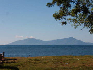
, on the extinct Wetar segment of the volcanic
Volcano
2. Bedrock3. Conduit 4. Base5. Sill6. Dike7. Layers of ash emitted by the volcano8. Flank| 9. Layers of lava emitted by the volcano10. Throat11. Parasitic cone12. Lava flow13. Vent14. Crater15...
Inner Banda Arc, between the Indonesia
Indonesia
Indonesia , officially the Republic of Indonesia , is a country in Southeast Asia and Oceania. Indonesia is an archipelago comprising approximately 13,000 islands. It has 33 provinces with over 238 million people, and is the world's fourth most populous country. Indonesia is a republic, with an...
n islands of Alor
Alor
Alor is the largest island in the Alor Archipelago located at the eastern-most end of the Lesser Sunda Islands that runs through southern Indonesia, which from the west include such islands as Bali, Lombok, Sumbawa, Komodo, and Flores....
and Wetar
Wetar
The tropical island of Wetar belongs to the Indonesian province of Maluku and is the largest island of the Barat Daya Islands . It lies east of the Lesser Sunda Islands, which include nearby Alor and Timor, but it is politically part of the Maluku Islands...
. Politically it comprises one of the subdistricts of the Dili District of East Timor. It is about 25 km long and 9 km wide, about 105 km² in area, and is inhabited by about 8000 people. The nearest island is the Indonesian island of Liran
Liran
Liran Island is a small island off the southwest coast of Wetar Island, Indonesia. 12 km to the southwest is the East Timorese island Atauro. Liran is the westernmost of the Barat Daya Islands in the province of Maluku.Liran is surrounded by coral reefs....
, 12 km to the northeast.
Name
The name means 'goat' in the local language, and it is also known as Kambing Island (Pulau Kambing) by the IndonesiaIndonesia
Indonesia , officially the Republic of Indonesia , is a country in Southeast Asia and Oceania. Indonesia is an archipelago comprising approximately 13,000 islands. It has 33 provinces with over 238 million people, and is the world's fourth most populous country. Indonesia is a republic, with an...
ns (Kambing means 'goat' in Indonesian
Indonesian language
Indonesian is the official language of Indonesia. Indonesian is a normative form of the Riau Islands dialect of Malay, an Austronesian language which has been used as a lingua franca in the Indonesian archipelago for centuries....
). It was so named because of the large number of goats kept there.
Atauro is also the name of a vessel in the Timor Leste Defence Force, the East Timorese patrol boat Atauro
East Timorese patrol boat Atauro
The East Timorese patrol boat Atauro is one of the two Albatroz class patrol boats operated by the Timor Leste Defence Force. She was built in the mid-1970s for the Portuguese Navy and was commissioned on 9 December 1974 as NRP Açor . She was donated to East Timor in January 2002 and was renamed...
Geography
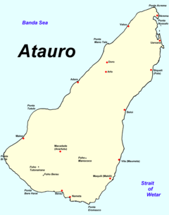
The island is separated into 5 districts, each surrounding a village: Biqueli and Beloi in the north, Macadade (formerly Anartutu) in the southwest, and Maquili and Vila Maumeta in the southeast. The largest town is Vila Maumeta. Other major towns include Pala, Uaroana, Arlo, Adara, and Berau. One bitumen road connects Vila Maumeta to Pala, with walking paths to the other villages on the island. In Indonesian times there was an airstrip, north of Vila Maumeta, but this is now unusable to fixed-wing aircraft (IATA designation: AUT (WPAT)).Mt. Manucoco is the highest point at 999m above sea level
Sea level
Mean sea level is a measure of the average height of the ocean's surface ; used as a standard in reckoning land elevation...
. The ocean strait between Atauro and Timor drops 3500m below sea level; conversely, it is much shallower along the ridge leading to Wetar. Geologists from Melbourne University are working together with the East Timor Energy Minerals and Resources Directorate (EMRD) and the Polytechnical Institute of Dili to make the first geological map of the island, in part to improve the infrastructure of the island.
Atauro is a small and unstable island with a rugged landscape, frequented by landslide
Landslide
A landslide or landslip is a geological phenomenon which includes a wide range of ground movement, such as rockfalls, deep failure of slopes and shallow debris flows, which can occur in offshore, coastal and onshore environments...
s and a shortage of fresh water
Fresh Water
Fresh Water is the debut album by Australian rock and blues singer Alison McCallum, released in 1972. Rare for an Australian artist at the time, it came in a gatefold sleeve...
, especially during the drier months. Fresh water spring
Spring (hydrosphere)
A spring—also known as a rising or resurgence—is a component of the hydrosphere. Specifically, it is any natural situation where water flows to the surface of the earth from underground...
s are present approximately 2km north of Berau, with minor reservoirs around Macadade, and the eastern slopes of Mt. Manucoco. Well
Water well
A water well is an excavation or structure created in the ground by digging, driving, boring or drilling to access groundwater in underground aquifers. The well water is drawn by an electric submersible pump, a trash pump, a vertical turbine pump, a handpump or a mechanical pump...
s along the coast provide water of poor quality to most coastal townships. In 2004 Portugal
Portugal
Portugal , officially the Portuguese Republic is a country situated in southwestern Europe on the Iberian Peninsula. Portugal is the westernmost country of Europe, and is bordered by the Atlantic Ocean to the West and South and by Spain to the North and East. The Atlantic archipelagos of the...
funded a project to improve the availability of water and its distribution infrastructure but the island remains critically short of water.
Atauro has two distinct seasons - wet
Wet season
The the wet season, or rainy season, is the time of year, covering one or more months, when most of the average annual rainfall in a region occurs. The term green season is also sometimes used as a euphemism by tourist authorities. Areas with wet seasons are dispersed across portions of the...
and dry
Dry season
The dry season is a term commonly used when describing the weather in the tropics. The weather in the tropics is dominated by the tropical rain belt, which oscillates from the northern to the southern tropics over the course of the year...
. Vegetation
Vegetation
Vegetation is a general term for the plant life of a region; it refers to the ground cover provided by plants. It is a general term, without specific reference to particular taxa, life forms, structure, spatial extent, or any other specific botanical or geographic characteristics. It is broader...
consists of open Eucalyptus sp. woodland, representative of its Australasia
Australasia
Australasia is a region of Oceania comprising Australia, New Zealand, the island of New Guinea, and neighbouring islands in the Pacific Ocean. The term was coined by Charles de Brosses in Histoire des navigations aux terres australes...
n affinities, on open slopes and hillsides commonly where limestone
Limestone
Limestone is a sedimentary rock composed largely of the minerals calcite and aragonite, which are different crystal forms of calcium carbonate . Many limestones are composed from skeletal fragments of marine organisms such as coral or foraminifera....
s outcrop. Rainforest
Rainforest
Rainforests are forests characterized by high rainfall, with definitions based on a minimum normal annual rainfall of 1750-2000 mm...
is present within valleys. The island has suffered from extensive clearing.
A ferry, the Nakroma, a gift from Germany, connects the island to the capital Dili
Dili
Dili, spelled Díli in Portuguese, is the capital, largest city, chief port and commercial centre of East Timor.-Geography and Administration:Dili lies on the northern coast of Timor island, the easternmost of the Lesser Sunda Islands....
, which takes about two hours. It can also be reached by fishermen's boats. Atauro is also being considered as a destination for eco-tourism, and its coral reefs are becoming known to scuba
Scuba diving
Scuba diving is a form of underwater diving in which a diver uses a scuba set to breathe underwater....
enthusiasts.
Culture
Atauro is unusual in East Timor because many of the northern inhabitants are Protestants, not CatholicRoman Catholic Church
The Catholic Church, also known as the Roman Catholic Church, is the world's largest Christian church, with over a billion members. Led by the Pope, it defines its mission as spreading the gospel of Jesus Christ, administering the sacraments and exercising charity...
s. They were evangelized by a Dutch Calvinist mission from Alor
Alor
Alor is the largest island in the Alor Archipelago located at the eastern-most end of the Lesser Sunda Islands that runs through southern Indonesia, which from the west include such islands as Bali, Lombok, Sumbawa, Komodo, and Flores....
in the early 20th century. There are also some Protestants among the southern population, as well.
The people of Atauro speak three dialects of Wetarese
Wetarese
Wetarese is the language of Wetar, an island in the south Maluku, Indonesia, as well as the nearby islands Liran and Atauro, the latter belonging to East Timor....
, which is mainly spoken on Wetar
Wetar
The tropical island of Wetar belongs to the Indonesian province of Maluku and is the largest island of the Barat Daya Islands . It lies east of the Lesser Sunda Islands, which include nearby Alor and Timor, but it is politically part of the Maluku Islands...
and Liran
Liran
Liran Island is a small island off the southwest coast of Wetar Island, Indonesia. 12 km to the southwest is the East Timorese island Atauro. Liran is the westernmost of the Barat Daya Islands in the province of Maluku.Liran is surrounded by coral reefs....
in Indonesia
Indonesia
Indonesia , officially the Republic of Indonesia , is a country in Southeast Asia and Oceania. Indonesia is an archipelago comprising approximately 13,000 islands. It has 33 provinces with over 238 million people, and is the world's fourth most populous country. Indonesia is a republic, with an...
.
History
- See also: History of East TimorHistory of East TimorEast Timor is a small country in Southeast Asia, officially known as Democratic Republic of Timor-Leste. The country comprises the eastern half of the island of Timor and the nearby islands of Atauro and Jaco. The first inhabitants are thought to be descendant of Australoid and Melanesian peoples...
The Netherlands and Portugal agreed Atauro to be Portuguese in the treaty of Lisbon 1859, but the Portuguese flag was not raised before 1884, when there was an official ceremony. The inhabitants of Atauro did not start to pay taxes to Portugal before 1905. Atauro was used as a prison
Prison
A prison is a place in which people are physically confined and, usually, deprived of a range of personal freedoms. Imprisonment or incarceration is a legal penalty that may be imposed by the state for the commission of a crime...
island soon after settlement by the Portuguese.
In Portuguese Timor
Portuguese Timor
Portuguese Timor was the name of East Timor when it was under Portuguese control. During this period, Portugal shared the island of Timor with the Netherlands East Indies, and later with Indonesia....
, Atauro was organized as part of the Dili municipality, coinciding with modern Dili District. When East Timor became independent, there was a proposal to reorganize the districts and split off Atauro as an autonomous area. However, that has not been put into effect, and it remains a subdistrict
Subdistricts of East Timor
The districts of East Timor are divided into 65 subdistricts, with one designated as the capital. Each subdistrict is divided into several villages , the smallest political division of East Timor...
of Dili District.
On August 11, 1975, when the UDT
Timorese Democratic Union
The Timorese Democratic Union is a conservative political party in East Timor. It was the first party to be established in the country in 1974, following the Carnation Revolution in Portugal....
mounted a coup in a bid to halt the increasing popularity of Fretilin, the Portuguese Governor Mário Lemos Pires
Mário Lemos Pires
Mário Lemos Pires was the last Portuguese governor of Portuguese Timor.-Historical background to governorship:Pires served from November 18, 1974 to November 27, 1975, but the administration was forced onto Atauro Island for the last three months of Portuguese rule following the UDT coup in...
fled to Atauro, from where he later attempted to broker an agreement between the two groups. He was urged by Fretilin to return and resume the decolonisation process, but he insisted that he was awaiting instructions from the government in Lisbon, then increasingly uninterested. The chaos ultimately led to the Indonesia
Indonesia
Indonesia , officially the Republic of Indonesia , is a country in Southeast Asia and Oceania. Indonesia is an archipelago comprising approximately 13,000 islands. It has 33 provinces with over 238 million people, and is the world's fourth most populous country. Indonesia is a republic, with an...
n occupation. The island became part of independent East Timor on May 20, 2002.