
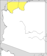
Arizona Strip
Encyclopedia

U.S. state
A U.S. state is any one of the 50 federated states of the United States of America that share sovereignty with the federal government. Because of this shared sovereignty, an American is a citizen both of the federal entity and of his or her state of domicile. Four states use the official title of...
of Arizona
Arizona
Arizona ; is a state located in the southwestern region of the United States. It is also part of the western United States and the mountain west. The capital and largest city is Phoenix...
lying north of the Colorado River
Colorado River
The Colorado River , is a river in the Southwestern United States and northwestern Mexico, approximately long, draining a part of the arid regions on the western slope of the Rocky Mountains. The watershed of the Colorado River covers in parts of seven U.S. states and two Mexican states...
. The difficulty of crossing the Grand Canyon
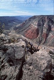
Grand Canyon
The Grand Canyon is a steep-sided canyon carved by the Colorado River in the United States in the state of Arizona. It is largely contained within the Grand Canyon National Park, the 15th national park in the United States...
causes this region to have more natural connections with southern Utah
Utah
Utah is a state in the Western United States. It was the 45th state to join the Union, on January 4, 1896. Approximately 80% of Utah's 2,763,885 people live along the Wasatch Front, centering on Salt Lake City. This leaves vast expanses of the state nearly uninhabited, making the population the...
and Nevada
Nevada
Nevada is a state in the western, mountain west, and southwestern regions of the United States. With an area of and a population of about 2.7 million, it is the 7th-largest and 35th-most populous state. Over two-thirds of Nevada's people live in the Las Vegas metropolitan area, which contains its...
than with the rest of Arizona.
General characteristics
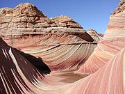
The Strip is very typical of the American West in its red-rock canyon country, and the aridArid
A region is said to be arid when it is characterized by a severe lack of available water, to the extent of hindering or even preventing the growth and development of plant and animal life...
ity of the climate, which leads to the predominance of sagebrush
Sagebrush
Sagebrush is a common name of a number of shrubby plant species in the genus Artemisia native to western North America;Or, the sagebrush steppe ecoregion, having one or more kinds of sagebrush, bunchgrasses and others;...
vegetation. However, the first European
European ethnic groups
The ethnic groups in Europe are the various ethnic groups that reside in the nations of Europe. European ethnology is the field of anthropology focusing on Europe....
settlers were witness to great stretches of grassland
Grassland
Grasslands are areas where the vegetation is dominated by grasses and other herbaceous plants . However, sedge and rush families can also be found. Grasslands occur naturally on all continents except Antarctica...
in such areas as House Rock Valley which are returning under better ranching practices. The land is also dotted with juniper
Juniper
Junipers are coniferous plants in the genus Juniperus of the cypress family Cupressaceae. Depending on taxonomic viewpoint, there are between 50-67 species of juniper, widely distributed throughout the northern hemisphere, from the Arctic, south to tropical Africa in the Old World, and to the...
trees, moving into pinyon pine
Pinyon pine
The pinyon pine group grows in the southwestern United States and in Mexico. The trees yield edible pinyon nuts, which were a staple of the Native Americans, and are still widely eaten...
and juniper forests, and eventually ponderosa pines, spruce
Spruce
A spruce is a tree of the genus Picea , a genus of about 35 species of coniferous evergreen trees in the Family Pinaceae, found in the northern temperate and boreal regions of the earth. Spruces are large trees, from tall when mature, and can be distinguished by their whorled branches and conical...
, firs, and aspen
Aspen
Populus section Populus, of the Populus genus, includes the aspen trees and the white poplar Populus alba. The five typical aspens are all native to cold regions with cool summers, in the north of the Northern Hemisphere, extending south at high altitudes in the mountains. The White Poplar, by...
in the higher elevations such as the Kaibab Plateau
Kaibab Plateau
The Kaibab Plateau is located in northern Arizona in the United States. The plateau, part of the larger Colorado Plateau, is bordered on the south by the Grand Canyon and reaches an elevation of 9241 feet above sea level. The plateau is divided between Kaibab National Forest and the "North Rim"...
.
It has been divided between Coconino County
Coconino County, Arizona
-2010:Whereas according to the 2010 U.S. Census Bureau:*61.7% White*1.2% Black*27.3% Native American*1.4% Asian*0.1% Native Hawaiian or Pacific Islander*3.1% Two or more races*5.2% Other races*13.5% Hispanic or Latino -2000:...
in the east (west of Kanab Creek
Kanab Creek
Kanab Creek is one of the many tributaries of the Grand Canyon. It begins in Kane County, Utah, just south of the watershed to the Great Basin and flows south to the Colorado River. It passes Kanab, Utah, crossing the border to Arizona near Fredonia...
) and Mohave County
Mohave County, Arizona
Mohave County is located in the northwestern corner of the U.S. state of Arizona. As of the 2010 census, its population was 200,186, an increase of 45,154 people since the 2000 census count of 155,032. The county seat is Kingman...
in the west. The only significant settlements are Fredonia
Fredonia, Arizona
Fredonia is a town in Coconino County, Arizona, United States. Fredonia is Arizona's northernmost town and the gateway to the North Rim of the Grand Canyon. Visitors enjoy seeing the Grand Canyon from the North Rim because they can experience the wonder and beauty without large crowds and high...
on Kanab Creek and Colorado City
Colorado City, Arizona
Colorado City is a town in Mohave County, Arizona, United States, and is located in a region known as the Arizona Strip. According to 2006 Census Bureau estimates, the population of the town was 4,607...
(the Strip's largest community) on the Utah border to the northwest (see also Hildale, Utah
Hildale, Utah
Hildale is a city in Washington County, Utah, United States. The population was 2,726 at the 2010 census.Hildale is a twin city to the more well-known Colorado City, Arizona, both of which straddle the border between Utah and Arizona. Hildale is the headquarters of the Fundamentalist Church of...
). In the extreme west on the Virgin River
Virgin River
The Virgin River is a tributary of the Colorado River in the U.S. states of Utah, Nevada, and Arizona. The river is about long. It was designated Utah's first wild and scenic river in 2009, during the centennial celebration of Zion National Park.-Course:...
is the small settlement of Littlefield
Littlefield, Arizona
Littlefield is an unincorporated community in Mohave County located in the Arizona Strip region of the U.S. state of Arizona. It is located along Interstate 15 approximately 10 miles northeast of Mesquite, Nevada...
just off Interstate 15
Interstate 15 in Arizona
Interstate 15 is an Interstate Highway, running from San Diego, California, United States, to the Canadian border, through Mohave County in northwest Arizona. Despite being isolated from the rest of Arizona, in the remote Arizona Strip, and short in length at , it remains notable for its scenic...
. However, the Strip provides the only route accessing the North Rim of the Grand Canyon
Grand Canyon
The Grand Canyon is a steep-sided canyon carved by the Colorado River in the United States in the state of Arizona. It is largely contained within the Grand Canyon National Park, the 15th national park in the United States...
, and numerous service communities catering to tourists exist along the Strip's main routes heading south from Jacob Lake
Jacob Lake, Arizona
Jacob Lake is a small unincorporated community on the Kaibab Plateau in Coconino County, Arizona, United States, at the junction of U.S. Route 89A and State Route 67...
.
The Strip has a total surface area of 7,878.11 square miles (20,404.2 km²). Of this, 7,856.45 square miles (20,348.12 km²) is land, and only 56.08 km² (21.653 sq mi, or 0.275%) is water. Its land area is larger than that of the state of Massachusetts
Massachusetts
The Commonwealth of Massachusetts is a state in the New England region of the northeastern United States of America. It is bordered by Rhode Island and Connecticut to the south, New York to the west, and Vermont and New Hampshire to the north; at its east lies the Atlantic Ocean. As of the 2010...
, and comprises 6.9 percent of Arizona's land area. About 64.4 percent of its area is in Mohave County and 35.6 percent in Coconino County. Its total population was 8,095 inhabitants at the 2000 census, with 6,221 residing in Mohave County and 1,874 in Coconino County. http://factfinder.census.gov/servlet/DTTable?_bm=y&-context=dt&-ds_name=DEC_2000_SF1_U&-CONTEXT=dt&-mt_name=DEC_2000_SF1_U_P001&-tree_id=4001&-transpose=N&-redoLog=false&-all_geo_types=N&-geo_id=06000US0400591836&-geo_id=06000US0401592244&-search_results=06000US0400591836&-_showChild=Y&-format=&-_lang=en&-show_geoid=Y
History
Since the area was first settled by Mormon Pioneers led by Jacob HamblinJacob Hamblin
Jacob Vernon Hamblin was a Western pioneer, Mormon missionary, and diplomat to various Native American Tribes of the Southwest and Great Basin. During his life, he helped settle large areas of southern Utah and northern Arizona where he was seen as an honest broker between Mormon settlers and the...
in the mid-19th century, the Arizona Strip has been one of the last strongholds of the nineteenth-century practice of polygamy
Polygamy
Polygamy is a marriage which includes more than two partners...
, though this practice was disavowed by The Church of Jesus Christ of Latter-day Saints (LDS Church) in 1890. Over the last century the region has been the subject of controversy because of the control groups such as the United Effort Plan, a polygamist Mormon offshoot, exert within the region; nonetheless, such groups remain merely a visible minority.
The Arizona Strip was long a cattleman's paradise with large stretches of grassy meadow in the valleys and the high Kaibab Plateau
Kaibab Plateau
The Kaibab Plateau is located in northern Arizona in the United States. The plateau, part of the larger Colorado Plateau, is bordered on the south by the Grand Canyon and reaches an elevation of 9241 feet above sea level. The plateau is divided between Kaibab National Forest and the "North Rim"...
as summer forage. At the beginning of the 20th century the Grand Canyon Cattle Company, otherwise known as the Bar Z Brand, ran upwards of 100,000 cattle throughout the strip. Land and water use often led to friction between competing brands, and there are accounts of limited range wars between different outfits and between sheepmen and cattlemen.
The strip had been a battleground between Native American and white settlers during the 19th century, with Navajo
Navajo people
The Navajo of the Southwestern United States are the largest single federally recognized tribe of the United States of America. The Navajo Nation has 300,048 enrolled tribal members. The Navajo Nation constitutes an independent governmental body which manages the Navajo Indian reservation in the...
parties crossing over the Colorado River and raiding Mormon settlements. Peace was largely maintained through the diplomatic efforts of Jacob Hamblin
Jacob Hamblin
Jacob Vernon Hamblin was a Western pioneer, Mormon missionary, and diplomat to various Native American Tribes of the Southwest and Great Basin. During his life, he helped settle large areas of southern Utah and northern Arizona where he was seen as an honest broker between Mormon settlers and the...
. It also served as the primary route from Utah into Arizona, as the Grand Canyon and the Colorado River serve as almost impenetrable barriers to the south.
Access
Navajo Bridge
Navajo Bridge crosses the Colorado River's Marble Canyon near Lee's Ferry in the US state of Arizona. Apart from the Glen Canyon Bridge a few miles upstream at Page, Arizona, it is the only roadway crossing of the river and the Grand Canyon for nearly...
and the Glen Canyon Dam
Glen Canyon Dam
Glen Canyon Dam is a concrete arch dam on the Colorado River in northern Arizona in the United States, just north of Page. The dam was built to provide hydroelectricity and flow regulation from the upper Colorado River Basin to the lower. Its reservoir is called Lake Powell, and is the second...
bridge, both at the eastern end on U.S. Route 89
U.S. Route 89
U.S. Route 89 is a north–south United States Highway with two sections, and one former section. The southern section runs for 848 miles from Flagstaff, Arizona, to the southern entrance of Yellowstone National Park...
and crossing the Colorado River, a few Arizona state highways and U.S. Route 89A at Fredonia, Arizona
Fredonia, Arizona
Fredonia is a town in Coconino County, Arizona, United States. Fredonia is Arizona's northernmost town and the gateway to the North Rim of the Grand Canyon. Visitors enjoy seeing the Grand Canyon from the North Rim because they can experience the wonder and beauty without large crowds and high...
. It does have multiple road links to Utah to the north; as a result, the region has stronger historic, economic and cultural ties to Utah than to Arizona. Residents of Littlefield, Arizona
Littlefield, Arizona
Littlefield is an unincorporated community in Mohave County located in the Arizona Strip region of the U.S. state of Arizona. It is located along Interstate 15 approximately 10 miles northeast of Mesquite, Nevada...
, and the surrounding northwest corner of the state, near Interstate 15
Interstate 15 in Arizona
Interstate 15 is an Interstate Highway, running from San Diego, California, United States, to the Canadian border, through Mohave County in northwest Arizona. Despite being isolated from the rest of Arizona, in the remote Arizona Strip, and short in length at , it remains notable for its scenic...
, must physically leave the state and reenter from Utah
Utah
Utah is a state in the Western United States. It was the 45th state to join the Union, on January 4, 1896. Approximately 80% of Utah's 2,763,885 people live along the Wasatch Front, centering on Salt Lake City. This leaves vast expanses of the state nearly uninhabited, making the population the...
, Nevada
Nevada
Nevada is a state in the western, mountain west, and southwestern regions of the United States. With an area of and a population of about 2.7 million, it is the 7th-largest and 35th-most populous state. Over two-thirds of Nevada's people live in the Las Vegas metropolitan area, which contains its...
, or California
California
California is a state located on the West Coast of the United States. It is by far the most populous U.S. state, and the third-largest by land area...
.
Four primary unpaved roads enter the core of the strip: from Mesquite, Nevada
Mesquite, Nevada
Mesquite is a city in Clark County, Nevada, United States, adjacent to the Arizona state line and northeast of Las Vegas. As of the 2010 United States Census, it had a population of 15,277. The city is located in the Virgin River Valley...
; St. George, Utah
St. George, Utah
St. George is a city located in the southwestern part of the U.S. state of Utah, and the county seat of Washington County, Utah. It is the principal city of and is included in the St. George, Utah, Metropolitan Statistical Area. The city is 119 miles northeast of Las Vegas, Nevada, and 303 miles ...
; Colorado City, Arizona
Colorado City, Arizona
Colorado City is a town in Mohave County, Arizona, United States, and is located in a region known as the Arizona Strip. According to 2006 Census Bureau estimates, the population of the town was 4,607...
; and Fredonia, Arizona
Fredonia, Arizona
Fredonia is a town in Coconino County, Arizona, United States. Fredonia is Arizona's northernmost town and the gateway to the North Rim of the Grand Canyon. Visitors enjoy seeing the Grand Canyon from the North Rim because they can experience the wonder and beauty without large crowds and high...
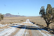
. All four are dirt/gravel and should not be driven by low-clearance vehicles. Motorists should check with the BLM locally before heading into the strip on these roads, and be prepared – even rangers may not know current conditions, such as snow/ice cover and washouts.
Protected lands
Most of the land in the Arizona Strip is managed by the United States Bureau of Land Management or the United States Forest ServiceUnited States Forest Service
The United States Forest Service is an agency of the United States Department of Agriculture that administers the nation's 155 national forests and 20 national grasslands, which encompass...
. The area holds several U.S. Wilderness Areas and U.S. National Monument
U.S. National Monument
A National Monument in the United States is a protected area that is similar to a National Park except that the President of the United States can quickly declare an area of the United States to be a National Monument without the approval of Congress. National monuments receive less funding and...
s and the Kaibab Indian Reservation
Kaibab Indian Reservation
The Kaibab Indian Reservation the home of the Kaibab Band of Paiute Indians, a federally recognized tribe of Southern Paiutes. The Indian reservation is located in northern part of the U.S. state of Arizona. It covers a land area of 188.75 square miles in northeastern Mohave County and...
. The southern part of the Arizona Strip includes the north rim of Grand Canyon National Park
Grand Canyon National Park
Grand Canyon National Park is the United States' 15th oldest national park and is located in Arizona. Within the park lies the Grand Canyon, a gorge of the Colorado River, considered to be one of the Wonders of the World. The park covers of unincorporated area in Coconino and Mohave counties.Most...
and the northern section of the Lake Mead National Recreation Area
Lake Mead National Recreation Area
Lake Mead National Recreation Area is located in southern Nevada and northwestern Arizona. The centerpieces of the National Recreation Area are its two large reservoirs: Lake Mead and Lake Mohave. These lakes cater to boaters, swimmers, sunbathers, and fishermen while the surrounding desert rewards...
.
National Monuments
- Grand Canyon-ParashantGrand Canyon-Parashant National MonumentGrand Canyon-Parashant National Monument is located on the northern edge of the Grand Canyon in northwest Arizona. It was established by Presidential Proclamation 7265 on January 11, 2000...
- Pipe SpringPipe Spring National MonumentPipe Spring National Monument is located in the U.S. state of Arizona, and is rich with American Indian, early explorer, and Mormon pioneer history...
- Vermilion CliffsVermilion Cliffs National MonumentVermilion Cliffs National Monument is located in Arizona, immediately south of the Utah state line. This National Monument, 294,000 acre in area, protects the Paria Plateau, Vermilion Cliffs, Coyote Buttes, and Paria Canyon...
National Recreation Areas
- Glen CanyonGlen Canyon National Recreation AreaGlen Canyon National Recreation Area is a recreation and conservation unit of the National Park Service that encompasses the area around Lake Powell and lower Cataract Canyon in Utah and Arizona, covering 1,254,429 acres of mostly desert...
- Lake MeadLake Mead National Recreation AreaLake Mead National Recreation Area is located in southern Nevada and northwestern Arizona. The centerpieces of the National Recreation Area are its two large reservoirs: Lake Mead and Lake Mohave. These lakes cater to boaters, swimmers, sunbathers, and fishermen while the surrounding desert rewards...
Wilderness Areas
- Beaver Dam MountainsBeaver Dam Mountains WildernessThe Beaver Dam Mountains Wilderness is a wilderness area located in northwestern Arizona and southwestern Utah, USA, within the arid Colorado Plateau region. The jagged mountains and gently sloping alluvial plain of the Beaver Dam Mountains straddle the border between the two states...
- Grand Wash Cliffs
- Kanab CreekKanab Creek WildernessKanab Creek Wilderness is a wilderness area located along the Coconino/Mohave County line in the U.S. state of Arizona, approximately south of Fredonia...
- Mount TrumbullMount Trumbull WildernessThe Mount Trumbull Wilderness is a 7,880 acre wilderness area located on the Uinkaret Plateau in the Arizona Strip. It is managed by the Bureau of Land Management....
- Mount LoganMount Logan WildernessThe Mount Logan Wilderness is a 14,650 acre U.S. wilderness area in the Arizona Strip. It is located about seven miles south of the Mount Trumbull Wilderness. The wilderness is within the Grand Canyon-Parashant National Monument and is managed by the BLM. -See also:*Wilderness*List of U.S....
- PaiutePaiute WildernessThe Paiute Wilderness is an 87,900 acre wilderness area located in the U.S. state of Arizona. The wilderness is administered by the Bureau of Land Management.-References:, accessed August 25, 2010.-See also:*Wilderness*Wilderness Act...
- Paria Canyon-Vermilion CliffsParia Canyon-Vermilion Cliffs WildernessThe Paria Canyon-Vermilion Cliffs Wilderness is a wilderness area located in northern Arizona and southern Utah, USA, within the arid Colorado Plateau region. The wilderness is composed of broad plateaus, tall escarpments, and deep canyons....
External links
- BLM Arizona Strip Field Office
- Kaibab National Forest
- Kane and Two Mile Ranches at Grand Canyon Trust
- Google map of trails