
.gif)
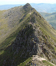
Arete (landform)
Encyclopedia

Rock (geology)
In geology, rock or stone is a naturally occurring solid aggregate of minerals and/or mineraloids.The Earth's outer solid layer, the lithosphere, is made of rock. In general rocks are of three types, namely, igneous, sedimentary, and metamorphic...
which is typically formed when two glacier
Glacier
A glacier is a large persistent body of ice that forms where the accumulation of snow exceeds its ablation over many years, often centuries. At least 0.1 km² in area and 50 m thick, but often much larger, a glacier slowly deforms and flows due to stresses induced by its weight...
s erode parallel U-shaped valley
U-shaped valley
A U-shaped valley also known as a glacial trough is one formed by the process of glaciation. It has a characteristic U-shape, with steep, straight sides, and a flat bottom. Glaciated valleys are formed when a glacier travels across and down a slope, carving the valley by the action of scouring...
s. The arête is a thin ridge
Ridge
A ridge is a geological feature consisting of a chain of mountains or hills that form a continuous elevated crest for some distance. Ridges are usually termed hills or mountains as well, depending on size. There are several main types of ridges:...
of rock that is left separating the two valleys. Arêtes can also form when two glacial cirques
Cirque (landform)
thumb|250 px|Two cirques with semi-permanent snowpatches in [[Abisko National Park]], [[Sweden]].A cirque or corrie is an amphitheatre-like valley head, formed at the head of a valley glacier by erosion...
erode headwards towards one another, although frequently this results in a saddle-shaped pass, called a col
Mountain pass
A mountain pass is a route through a mountain range or over a ridge. If following the lowest possible route, a pass is locally the highest point on that route...
. The edge is then sharpened by freeze-thaw weathering
Frost weathering
Frost weathering is a collective name for several mechanical weathering processes induced by stresses created by the freezing of water into ice. The term serves as an umbrella term for a variety of processes such as frost shattering, frost wedging and cryofracturing...
, and the slope on either side of the arete steepened through mass wasting
Mass wasting
Mass wasting, also known as slope movement or mass movement, is the geomorphic process by which soil, regolith, and rock move downslope under the force of gravity. Types of mass wasting include creep, slides, flows, topples, and falls, each with its own characteristic features, and taking place...
events and the erosion of exposed, unstable rock. The word "arête" is actually French
French language
French is a Romance language spoken as a first language in France, the Romandy region in Switzerland, Wallonia and Brussels in Belgium, Monaco, the regions of Quebec and Acadia in Canada, and by various communities elsewhere. Second-language speakers of French are distributed throughout many parts...
for edge or ridge; similar features in the Alps
Alps
The Alps is one of the great mountain range systems of Europe, stretching from Austria and Slovenia in the east through Italy, Switzerland, Liechtenstein and Germany to France in the west....
are described with the German
German language
German is a West Germanic language, related to and classified alongside English and Dutch. With an estimated 90 – 98 million native speakers, German is one of the world's major languages and is the most widely-spoken first language in the European Union....
equivalent term Grat or Kamm (comb
Comb
A comb is a toothed device used in hair care for straightening and cleaning hair or other fibres. Combs are among the oldest tools found by archaeologists...
).
Where three or more cirques meet, a pyramidal peak
Pyramidal peak
A pyramidal peak, or sometimes in its most extreme form called a glacial horn, is a mountaintop that has been modified by the action of ice during glaciation and frost weathering...
is created.
Cleaver
A cleaver is a type of arête that separates a unified flow of glacial iceIce
Ice is water frozen into the solid state. Usually ice is the phase known as ice Ih, which is the most abundant of the varying solid phases on the Earth's surface. It can appear transparent or opaque bluish-white color, depending on the presence of impurities or air inclusions...
from its uphill side into two glaciers flanking, and flowing parallel to, the ridge. Cleaver gets its name from the way it resembles a meat cleaver slicing meat into two parts. A cleaver may be thought of as analogous to an island
Island
An island or isle is any piece of sub-continental land that is surrounded by water. Very small islands such as emergent land features on atolls can be called islets, cays or keys. An island in a river or lake may be called an eyot , or holm...
in a river
River
A river is a natural watercourse, usually freshwater, flowing towards an ocean, a lake, a sea, or another river. In a few cases, a river simply flows into the ground or dries up completely before reaching another body of water. Small rivers may also be called by several other names, including...
. A common situation has the two flanking glaciers melting to their respective ends before their courses can bring them back together; the exceedingly rare analogy is a situation of the two branches of a river drying up, before the downstream tip of the island, by evaporation or absorption into the ground.
The location of a cleaver is often an important factor in the choice among routes for glacier flow. For example, following a cleaver up or down a mountain may avoid travelling on or under an unstable glacial, snow, or rock area. This is usually the case on those summer routes to the summit whose lower portions are on the south face of Mount Rainier
Mount Rainier
Mount Rainier is a massive stratovolcano located southeast of Seattle in the state of Washington, United States. It is the most topographically prominent mountain in the contiguous United States and the Cascade Volcanic Arc, with a summit elevation of . Mt. Rainier is considered one of the most...
: climbers traverse the "flats" of Ingraham Glacier, but ascend Disappointment Cleaver and follow its ridgeline rather than ascending the headwall
Headwall
In physical geography and geology the headwall of a glacial cirque is its highest cliff.In civil engineering, a headwall is a small retaining wall placed at the outlet of a stormwater pipe or culvert....
either of that glacier or (on the other side of the cleaver) of Emmons Glacier
Emmons Glacier
Emmons Glacier is a glacier on the northeast flank of Mount Rainier, in Washington. At , it has the largest surface area of any glacier in the contiguous United States. The glacier was named after the geologist Samuel Franklin Emmons after his involvement in a survey of Mount Rainier in...
.
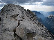
Examples
Notable examples of arêtes include:- Knife Edge, on Mount KatahdinMount KatahdinMount Katahdin is the highest mountain in Maine at . Named Katahdin by the Penobscot Indians, the term means "The Greatest Mountain". Katahdin is the centerpiece of Baxter State Park: a steep, tall mountain formed from underground magma. The flora and fauna on the mountain are typical of those...
, MaineMaineMaine is a state in the New England region of the northeastern United States, bordered by the Atlantic Ocean to the east and south, New Hampshire to the west, and the Canadian provinces of Quebec to the northwest and New Brunswick to the northeast. Maine is both the northernmost and easternmost... - Clouds RestClouds RestClouds Rest is a mountain in Yosemite National Park east northeast of Yosemite Village, California. Although there are many peaks in the park having far greater elevation, Clouds Rest's proximity to the valley gives it a very high degree of visual prominence....
, in the Sierra Nevada, CaliforniaCaliforniaCalifornia is a state located on the West Coast of the United States. It is by far the most populous U.S. state, and the third-largest by land area... - The Minarets, in the Sierra Nevada, California
- The Garden WallGarden WallThe Garden Wall is a steep alpine area within Glacier National Park well known during the summer months to be heavily covered in dozens of species of flowering plants and shrubs...
, in Glacier National Park, MontanaMontanaMontana is a state in the Western United States. The western third of Montana contains numerous mountain ranges. Smaller, "island ranges" are found in the central third of the state, for a total of 77 named ranges of the Rocky Mountains. This geographical fact is reflected in the state's name,...
(image to right) - The SawtoothThe SawtoothThe Sawtooth is a jagged arête joining Mount Bierstadt to Mount Evans, in Colorado, United States., and is also the name of the highest peak at the northeast end of this ridge. The three peaks along this arête resemble the teeth of a saw, leading to its name...
, in the Colorado RockiesColorado RockiesThe Colorado Rockies are a Major League Baseball team based in Denver, Colorado. Established in 1991, they started play in 1993 and are in the West Division of the National League. The team is named after the Rocky Mountains... - La Peineta, in the AndesAndesThe Andes is the world's longest continental mountain range. It is a continual range of highlands along the western coast of South America. This range is about long, about to wide , and of an average height of about .Along its length, the Andes is split into several ranges, which are separated...
of Los Ríos RegionLos Ríos RegionThe XIV Los Ríos Region is one of Chile's 15 first order administrative divisions. Its capital is Valdivia. Pop. 356,396 . It began to operate as region on October 2, 2007. It was created by subdividing the Los Lagos Region in southern Chile...
, ChileChileChile ,officially the Republic of Chile , is a country in South America occupying a long, narrow coastal strip between the Andes mountains to the east and the Pacific Ocean to the west. It borders Peru to the north, Bolivia to the northeast, Argentina to the east, and the Drake Passage in the far... - Crib GochCrib GochCrib Goch is described as a "knife-edged" arête in the Snowdonia National Park in Gwynedd, Wales. The name means red comb in the Welsh language, presumably referring to the serrated ridge and the colour of some of the rocks....
, in Snowdonia National ParkSnowdoniaSnowdonia is a region in north Wales and a national park of in area. It was the first to be designated of the three National Parks in Wales, in 1951.-Name and extent:...
, WalesWalesWales is a country that is part of the United Kingdom and the island of Great Britain, bordered by England to its east and the Atlantic Ocean and Irish Sea to its west. It has a population of three million, and a total area of 20,779 km²... - Striding Edge in the EnglishEnglandEngland is a country that is part of the United Kingdom. It shares land borders with Scotland to the north and Wales to the west; the Irish Sea is to the north west, the Celtic Sea to the south west, with the North Sea to the east and the English Channel to the south separating it from continental...
Lake DistrictLake DistrictThe Lake District, also commonly known as The Lakes or Lakeland, is a mountainous region in North West England. A popular holiday destination, it is famous not only for its lakes and its mountains but also for its associations with the early 19th century poetry and writings of William Wordsworth... - The Catwalk, in the Olympic National ParkOlympic National ParkOlympic National Park is located in the U.S. state of Washington, in the Olympic Peninsula. The park can be divided into four basic regions: the Pacific coastline, alpine areas, the west side temperate rainforest and the forests of the drier east side. U.S...
, state of Washington - The Carn Mor DeargCarn Mòr DeargCàrn Mòr Dearg is the eighth highest mountain in Scotland. It is situated in the west of Scotland, close to the town of Fort William, in Lochaber, Highland...
arête on to Ben NevisBen NevisBen Nevis is the highest mountain in the British Isles. It is located at the western end of the Grampian Mountains in the Lochaber area of the Scottish Highlands, close to the town of Fort William....
, ScotlandScotlandScotland is a country that is part of the United Kingdom. Occupying the northern third of the island of Great Britain, it shares a border with England to the south and is bounded by the North Sea to the east, the Atlantic Ocean to the north and west, and the North Channel and Irish Sea to the...
.