
April 6-8, 2006 Tornado Outbreak
Encyclopedia
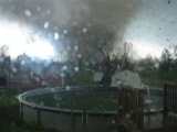
The April 6-8, 2006 Tornado Outbreak was a major tornado outbreak
in the Central
and parts of the Southern United States
that began on April 6, 2006 in the Great Plains
and continued until April 8 in South Carolina
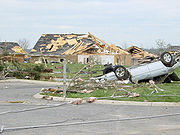
, with most of the activity on April 7. The hardest-hit area was Middle Tennessee
where several strong tornadoes devastated entire neighborhoods and left nine people dead. The worst damage took place in Gallatin, Tennessee
. Other communities north of Nashville
were also hard hit.
There were 73 tornadoes confirmed across 13 states, with the bulk of them coming on the afternoon and evening of April 7 across the South, particularly in Tennessee
. In total, 13 deaths were reported as a result of the severe weather (12 of them in Tennessee) and over $1.5 billion in damage was reported, of which over $630 million was in Middle Tennessee. It was the third major outbreak of 2006, hot on the heels of a major outbreak
on April 2. It was also the worst disaster event in Middle Tennessee since the Nashville tornado outbreak on April 16, 1998.
 The outbreak took place as a result of a powerful low pressure system
over the Midwest
that produced a strong cold front
which tracked eastward across the South. The dry, cold air behind the cold front combined with warm, humid air from the Gulf of Mexico
to allow severe thunderstorms to form, particularly on April 7.
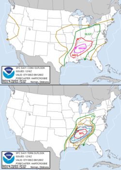
The Storm Prediction Center
issued a high risk for severe weather for both April 6 and April 7 in the areas likely to be affected. Conditions were favorable for an extremely strong tornado outbreak on both days.
Activity was not as great as expected on April 6, with only 12 tornadoes confirmed, mostly in Kansas
. Several of the tornadoes were damaging, but no fatalities and only a few injuries were reported. The reason for the relatively modest activity was due to the more stable than expected air mass that day over the region, with lower dewpoints and less wind shear
despite the absence of a cap which would have otherwise allowed a massive outbreak.
Conditions changed on April 7 in the South as the system moved eastward, with the cold front entering a more conducive environment. The increased wind shear
, combined with the high heat and humidity
, allowed tornadoes to begin forming in the late morning, continuing throughout the afternoon, evening, and even into the overnight hours. By the end of the day, a total of 48 tornadoes had been reported, several of which caused significant damage and loss of life. The most violent tornadoes hit in Middle Tennessee
, where 12 people were killed. In addition to the tornadoes, there were many reports of hail
as large as baseball
s, powerful microburst
s and straight-line winds, as well as local flood
ing. Extensive damage was also reported in the northern suburbs of Atlanta, Georgia
as the storms reached that area overnight into the early morning of April 8.
Despite a lower risk of activity on April 8, the severe weather continued in Alabama
, South Carolina
and Georgia
(mostly in the early morning hours) with another 13 tornadoes reported before the outbreak finally ended as the system moved offshore into the Atlantic Ocean
. Over the three day period, 73 tornadoes were confirmed.
 The most destructive supercell of the outbreak developed just northwest of Nashville
at about 1:30 pm CDT (1830 UTC) on April 7 in Dickson County. It would then track across the northern suburbs of Nashville through Cheatham, Davidson
, and Sumner
counties, killing nine people and damaging or destroying an estimated 1,000 homes.
The first tornado touched down near Charlotte
at 1:30 pm CDT (1830 UTC). That tornado was a rated as a strong F3. Severe and extensive damage was reported in that area as well as in Greenbrier
. At least 12 houses, including several mobile homes, were destroyed. In addition at least 50 other houses were damaged, most of which sustained heavy damage. The tornado tracked towards Ashland City
inflicting more significant damage, including numerous houses and businesses. Many trees and power lines were also knocked down. The worst impact was felt at Centennial Medical Center's Ashland City hospital
site, which was damaged and lost its heating and air conditioning
system, forcing several patients to be transferred to Nashville hospitals. No injuries were reported there.
 The supercell then tracked into Davidson County and the northernmost part of Nashville. It was initially reported that new tornado touched down at about 2:00 p.m. CDT (1900 UTC) in Whites Creek, a largely rural area with light-scale development along US 431
near Old Hickory Boulevard. Damage was reported along a path stretching out to I-24
near Exit 40. The Tennessee Emergency Management Agency reported that 15 houses and 10 other buildings were destroyed in the area, about 5 miles (8 km) north of the urban part of Nashville. However, that tornado was never confirmed; it was likely straight-line wind damage.
The supercell then tracked into Goodlettsville
where another tornado touched down, striking the suburban area at around 2:15 pm CDT (1915 UTC) with considerable force. It hit a residential subdivision in the center of town, with considerable damage reported at City Hall
, Two local churches(Bakers Chapel CME Church and Metro Baptist Church), and to numerous houses, some of which were demolished. In total, 25 homes were destroyed in Goodlettsville and another 44 homes or businesses were damaged. The tornado then heavily damaged a busy commercial area along Long Hollow Pike, blowing the roofs off of several buildings and heavily damaging others. It also caused severe damage to the electricity
network in the area, which was out for several days in some subdivisions in Goodlettsville
. The tornado also caused a traffic nightmare as a direct result of tornado-related accidents on I-65
at Exit 97 just before rush hour
. No deaths were reported in Goodlettsville
although seven injuries were reported, and public shelters were set up at two locations.
 The tornado continued into Sumner County
just north of Hendersonville
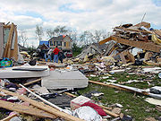
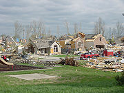
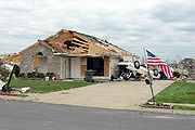
. It damaged numerous houses in that area before entering and devastating Gallatin
with F3 damage at about 2:30 pm CDT (1930 UTC). Several entire subdivisions, primarily along the north shore of Old Hickory Lake
, were destroyed or flattened, killing nine people and injuring 121. Three of the deaths were on the southwest end of Gallatin near Old Hickory Lake, and the other six were in the area of South Water Avenue. Over 700 houses were damaged or destroyed, including about 80 in Hendersonville. The Woodhaven subdivision of Gallatin was later discovered to have been poorly constructed (considering the value of the homes), with boards nailed to the cinder block
s at the base of the foundation.
Volunteer State Community College
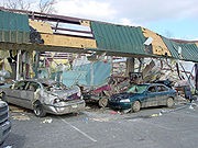
suffered extensive damage to numerous buildings, briefly trapping many students before they were rescued with only a few minor injuries. The front lawn of the college was littered with debris from buildings after the tornado. Damage to the campus was estimated at $56 million. The public relations director for the college, Angie Jowers, stated that having routine tornado drills paid off that day, as no one was killed on the campus. A commercial area was also hit hard, along with three large car dealership
s near Vol State, which saw hundreds of cars destroyed.
 Station Camp High School
, a local high school, also received notable damage from this storm. The tornado affected its large athletic complex, tearing parts of the roof off and flooding the gymnasium. Damage was also sustained to student and faculty vehicles. The tornado lifted shortly thereafter, however the supercell continued eastward and tornado warning
s were issued east of Gallatin as well. Total damage from the supercell tornadoes was estimated at over $650 million.
Coincidentally, the outbreak also cut short the first of a two-day emergency preparedness drill to be held on April 7 and 8 in four Middle Tennessee counties: Davidson
, Williamson
, Sumner
, and Wilson. The second day was canceled.
The second tornado in Warren County, also an F1, occurred near the small town of Morrison, Tennessee
, about 9 miles (14.5 km) southwest of the county seat of McMinnville
. It touched down along Caney Branch Road where there was extensive damage to a barn and a cinder block building, and numerous large trees were downed. The third and last fatality in Warren County occurred in a trailer home on Bonner Road. The tornado continued slightly south of east in the County Club subdivision, where several homes sustained roof damage and outbuildings were destroyed. The width of this tornado was 100 yards (91.4 m), with a path length of 4 miles (6.4 km).
 On the night after the tornado hit Gallatin, there were many reports of looting
in the devastated community. A nightly curfew
was required to combat the looting and maintain order in the community. The 269th Military Police Company (TN Nat'l Guard) was called in after the tornado hit to help with security and the removal of debris. It would take 10 days for Volunteer State Community College to re-open after the tornado hit.
On September 26, the Greater Nashville Regional Council awarded the authorities involved in the recovery (including the municipalities of Sumner County) the Marshall S. Stuart Memorial Award for outstanding intergovernmental cooperation after the tornado. The quick response by other local authorities, counties and cities was congratulated.
In early October 2006, an episode of Extreme Makeover: Home Edition
featured a family from Hendersonville that had their home being rebuilt after it was destroyed by the tornado. However, insurance issues plus personal injuries held back the recovery for many, and some neighborhoods have been slow to recover. Nonetheless, many homes have been rebuilt in the area.
Tornado outbreak
While there is no single agreed upon definition, generally at least 6-10 tornadoes produced by the same synoptic scale weather system is considered a tornado outbreak. The tornadoes usually occur within the same day, or continue into the early morning hours of the succeeding day, and within the...
in the Central
Central United States
The Central United States is sometimes conceived as between the Eastern United States and Western United States as part of a three-region model, roughly coincident with the Midwestern United States plus the western and central portions of the Southern United States; the term is also sometimes used...
and parts of the Southern United States
Southern United States
The Southern United States—commonly referred to as the American South, Dixie, or simply the South—constitutes a large distinctive area in the southeastern and south-central United States...
that began on April 6, 2006 in the Great Plains
Great Plains
The Great Plains are a broad expanse of flat land, much of it covered in prairie, steppe and grassland, which lies west of the Mississippi River and east of the Rocky Mountains in the United States and Canada. This area covers parts of the U.S...
and continued until April 8 in South Carolina
South Carolina
South Carolina is a state in the Deep South of the United States that borders Georgia to the south, North Carolina to the north, and the Atlantic Ocean to the east. Originally part of the Province of Carolina, the Province of South Carolina was one of the 13 colonies that declared independence...
, with most of the activity on April 7. The hardest-hit area was Middle Tennessee
Middle Tennessee
Middle Tennessee is a distinct portion of the state of Tennessee, delineated according to state law as the 41 counties in the Middle Grand Division of Tennessee....
where several strong tornadoes devastated entire neighborhoods and left nine people dead. The worst damage took place in Gallatin, Tennessee
Gallatin, Tennessee
Gallatin is a city in and the county seat of Sumner County, Tennessee, United States, along a navigable tributary of the Cumberland River. The population was 23,230 at the 2000 census. Named for U.S...
. Other communities north of Nashville
Nashville, Tennessee
Nashville is the capital of the U.S. state of Tennessee and the county seat of Davidson County. It is located on the Cumberland River in Davidson County, in the north-central part of the state. The city is a center for the health care, publishing, banking and transportation industries, and is home...
were also hard hit.
There were 73 tornadoes confirmed across 13 states, with the bulk of them coming on the afternoon and evening of April 7 across the South, particularly in Tennessee
Tennessee
Tennessee is a U.S. state located in the Southeastern United States. It has a population of 6,346,105, making it the nation's 17th-largest state by population, and covers , making it the 36th-largest by total land area...
. In total, 13 deaths were reported as a result of the severe weather (12 of them in Tennessee) and over $1.5 billion in damage was reported, of which over $630 million was in Middle Tennessee. It was the third major outbreak of 2006, hot on the heels of a major outbreak
April 2, 2006 Tornado Outbreak
The April 2, 2006 Central United States tornado outbreak was a series of tornadoes that occurred during the late afternoon and evening of April 2, 2006 in the central United States. It was the second major outbreak of 2006, in the same area that suffered considerable destruction in a previous...
on April 2. It was also the worst disaster event in Middle Tennessee since the Nashville tornado outbreak on April 16, 1998.
Meteorological synopsis
Low pressure area
A low-pressure area, or "low", is a region where the atmospheric pressure at sea level is below that of surrounding locations. Low-pressure systems form under areas of wind divergence which occur in upper levels of the troposphere. The formation process of a low-pressure area is known as...
over the Midwest
Midwestern United States
The Midwestern United States is one of the four U.S. geographic regions defined by the United States Census Bureau, providing an official definition of the American Midwest....
that produced a strong cold front
Cold front
A cold front is defined as the leading edge of a cooler mass of air, replacing a warmer mass of air.-Development of cold front:The cooler and denser air wedges under the less-dense warmer air, lifting it...
which tracked eastward across the South. The dry, cold air behind the cold front combined with warm, humid air from the Gulf of Mexico
Gulf of Mexico
The Gulf of Mexico is a partially landlocked ocean basin largely surrounded by the North American continent and the island of Cuba. It is bounded on the northeast, north and northwest by the Gulf Coast of the United States, on the southwest and south by Mexico, and on the southeast by Cuba. In...
to allow severe thunderstorms to form, particularly on April 7.
The Storm Prediction Center
Storm Prediction Center
The Storm Prediction Center , located in Norman, Oklahoma, is tasked with forecasting the risk of severe thunderstorms and tornadoes in the contiguous United States. The agency issues convective outlooks, mesoscale discussions, and watches as a part of this process...
issued a high risk for severe weather for both April 6 and April 7 in the areas likely to be affected. Conditions were favorable for an extremely strong tornado outbreak on both days.
Activity was not as great as expected on April 6, with only 12 tornadoes confirmed, mostly in Kansas
Kansas
Kansas is a US state located in the Midwestern United States. It is named after the Kansas River which flows through it, which in turn was named after the Kansa Native American tribe, which inhabited the area. The tribe's name is often said to mean "people of the wind" or "people of the south...
. Several of the tornadoes were damaging, but no fatalities and only a few injuries were reported. The reason for the relatively modest activity was due to the more stable than expected air mass that day over the region, with lower dewpoints and less wind shear
Wind shear
Wind shear, sometimes referred to as windshear or wind gradient, is a difference in wind speed and direction over a relatively short distance in the atmosphere...
despite the absence of a cap which would have otherwise allowed a massive outbreak.
| State | Total | County | County total |
|---|---|---|---|
| Tennessee Tennessee Tennessee is a U.S. state located in the Southeastern United States. It has a population of 6,346,105, making it the nation's 17th-largest state by population, and covers , making it the 36th-largest by total land area... |
12 | Sumner Sumner County, Tennessee Sumner County is a county located in the U.S. state of Tennessee. As of 2000, the population was 130,449. Its county seat is Gallatin, but its largest town is Hendersonville... |
9 |
| Warren | 3 | ||
| Alabama Alabama Alabama is a state located in the southeastern region of the United States. It is bordered by Tennessee to the north, Georgia to the east, Florida and the Gulf of Mexico to the south, and Mississippi to the west. Alabama ranks 30th in total land area and ranks second in the size of its inland... |
1 | Marion Marion County, Alabama Marion County is a county of the U.S. state of Alabama. Marion County was created by an act of the Alabama Territorial General Assembly on February 13, 1818. The county is located in the northwestern part of the state, bounded on the west by the state of Mississippi. It encompasses . Marion County... |
1 |
| Totals | 13 | ||
| All deaths are tornado-related | |||
Wind shear
Wind shear, sometimes referred to as windshear or wind gradient, is a difference in wind speed and direction over a relatively short distance in the atmosphere...
, combined with the high heat and humidity
Humidity
Humidity is a term for the amount of water vapor in the air, and can refer to any one of several measurements of humidity. Formally, humid air is not "moist air" but a mixture of water vapor and other constituents of air, and humidity is defined in terms of the water content of this mixture,...
, allowed tornadoes to begin forming in the late morning, continuing throughout the afternoon, evening, and even into the overnight hours. By the end of the day, a total of 48 tornadoes had been reported, several of which caused significant damage and loss of life. The most violent tornadoes hit in Middle Tennessee
Middle Tennessee
Middle Tennessee is a distinct portion of the state of Tennessee, delineated according to state law as the 41 counties in the Middle Grand Division of Tennessee....
, where 12 people were killed. In addition to the tornadoes, there were many reports of hail
Hail
Hail is a form of solid precipitation. It consists of balls or irregular lumps of ice, each of which is referred to as a hail stone. Hail stones on Earth consist mostly of water ice and measure between and in diameter, with the larger stones coming from severe thunderstorms...
as large as baseball
Baseball
Baseball is a bat-and-ball sport played between two teams of nine players each. The aim is to score runs by hitting a thrown ball with a bat and touching a series of four bases arranged at the corners of a ninety-foot diamond...
s, powerful microburst
Microburst
A microburst is a very localized column of sinking air, producing damaging divergent and straight-line winds at the surface that are similar to, but distinguishable from, tornadoes, which generally have convergent damage. There are two types of microbursts: wet microbursts and dry microbursts...
s and straight-line winds, as well as local flood
Flash flood
A flash flood is a rapid flooding of geomorphic low-lying areas—washes, rivers, dry lakes and basins. It may be caused by heavy rain associated with a storm, hurricane, or tropical storm or meltwater from ice or snow flowing over ice sheets or snowfields...
ing. Extensive damage was also reported in the northern suburbs of Atlanta, Georgia
Atlanta, Georgia
Atlanta is the capital and most populous city in the U.S. state of Georgia. According to the 2010 census, Atlanta's population is 420,003. Atlanta is the cultural and economic center of the Atlanta metropolitan area, which is home to 5,268,860 people and is the ninth largest metropolitan area in...
as the storms reached that area overnight into the early morning of April 8.
Despite a lower risk of activity on April 8, the severe weather continued in Alabama
Alabama
Alabama is a state located in the southeastern region of the United States. It is bordered by Tennessee to the north, Georgia to the east, Florida and the Gulf of Mexico to the south, and Mississippi to the west. Alabama ranks 30th in total land area and ranks second in the size of its inland...
, South Carolina
South Carolina
South Carolina is a state in the Deep South of the United States that borders Georgia to the south, North Carolina to the north, and the Atlantic Ocean to the east. Originally part of the Province of Carolina, the Province of South Carolina was one of the 13 colonies that declared independence...
and Georgia
Georgia (U.S. state)
Georgia is a state located in the southeastern United States. It was established in 1732, the last of the original Thirteen Colonies. The state is named after King George II of Great Britain. Georgia was the fourth state to ratify the United States Constitution, on January 2, 1788...
(mostly in the early morning hours) with another 13 tornadoes reported before the outbreak finally ended as the system moved offshore into the Atlantic Ocean
Atlantic Ocean
The Atlantic Ocean is the second-largest of the world's oceanic divisions. With a total area of about , it covers approximately 20% of the Earth's surface and about 26% of its water surface area...
. Over the three day period, 73 tornadoes were confirmed.
Confirmed tornadoes
North Nashville area supercell
Nashville, Tennessee
Nashville is the capital of the U.S. state of Tennessee and the county seat of Davidson County. It is located on the Cumberland River in Davidson County, in the north-central part of the state. The city is a center for the health care, publishing, banking and transportation industries, and is home...
at about 1:30 pm CDT (1830 UTC) on April 7 in Dickson County. It would then track across the northern suburbs of Nashville through Cheatham, Davidson
Davidson County, Tennessee
Davidson County is a county located in the U.S. state of Tennessee. As of 2010, the population was 626,681. Its county seat is Nashville.In 1963, the City of Nashville and the Davidson County government merged, so the county government is now known as the "Metropolitan Government of Nashville and...
, and Sumner
Sumner County, Tennessee
Sumner County is a county located in the U.S. state of Tennessee. As of 2000, the population was 130,449. Its county seat is Gallatin, but its largest town is Hendersonville...
counties, killing nine people and damaging or destroying an estimated 1,000 homes.
The first tornado touched down near Charlotte
Charlotte, Tennessee
Charlotte is a town in Dickson County, Tennessee, United States. The population was 1,153 at the 2000 census. It is the county seat of Dickson County.-Geography:...
at 1:30 pm CDT (1830 UTC). That tornado was a rated as a strong F3. Severe and extensive damage was reported in that area as well as in Greenbrier
Greenbrier, Tennessee
Greenbrier is a town in Robertson County, Tennessee, United States. The population was 4,940 at the 2000 census.-Geography:Greenbrier is located at .According to the United States Census Bureau:...
. At least 12 houses, including several mobile homes, were destroyed. In addition at least 50 other houses were damaged, most of which sustained heavy damage. The tornado tracked towards Ashland City
Ashland City, Tennessee
Ashland City is a town in Cheatham County, Tennessee, United States. The population was 3,641 at the 2000 census. It is the county seat of Cheatham County.-History:Ashland City was created in 1856 as a county seat for the newly-established Cheatham County...
inflicting more significant damage, including numerous houses and businesses. Many trees and power lines were also knocked down. The worst impact was felt at Centennial Medical Center's Ashland City hospital
Hospital
A hospital is a health care institution providing patient treatment by specialized staff and equipment. Hospitals often, but not always, provide for inpatient care or longer-term patient stays....
site, which was damaged and lost its heating and air conditioning
Air conditioning
An air conditioner is a home appliance, system, or mechanism designed to dehumidify and extract heat from an area. The cooling is done using a simple refrigeration cycle...
system, forcing several patients to be transferred to Nashville hospitals. No injuries were reported there.
U.S. Route 431
U.S. Route 431 is a spur of U.S. Route 31. It currently runs for 556 miles from Owensboro, Kentucky at U.S. Route 60 to Dothan, Alabama, at U.S. Route 231 and U.S. Route 84. Through many parts of US 431 it is a two lane with not many places of it being a four lane highway.-Alabama:U.S. 431 is...
near Old Hickory Boulevard. Damage was reported along a path stretching out to I-24
Interstate 24
Interstate 24 is an Interstate Highway in the Midwestern and Southeastern United States. It runs diagonally from Interstate 57 to Chattanooga, Tennessee, at Interstate 75....
near Exit 40. The Tennessee Emergency Management Agency reported that 15 houses and 10 other buildings were destroyed in the area, about 5 miles (8 km) north of the urban part of Nashville. However, that tornado was never confirmed; it was likely straight-line wind damage.
The supercell then tracked into Goodlettsville
Goodlettsville, Tennessee
Goodlettsville is a city in Davidson and Sumner counties in the U.S. state of Tennessee. Goodlettsville was incorporated as a city in 1958 with a population of just over 3,000 residents; at the 2000 census, the city had a total population of 13,780. Goodlettsville chose to remain autonomous in 1963...
where another tornado touched down, striking the suburban area at around 2:15 pm CDT (1915 UTC) with considerable force. It hit a residential subdivision in the center of town, with considerable damage reported at City Hall
City hall
In local government, a city hall, town hall or a municipal building or civic centre, is the chief administrative building of a city...
, Two local churches(Bakers Chapel CME Church and Metro Baptist Church), and to numerous houses, some of which were demolished. In total, 25 homes were destroyed in Goodlettsville and another 44 homes or businesses were damaged. The tornado then heavily damaged a busy commercial area along Long Hollow Pike, blowing the roofs off of several buildings and heavily damaging others. It also caused severe damage to the electricity
Electricity
Electricity is a general term encompassing a variety of phenomena resulting from the presence and flow of electric charge. These include many easily recognizable phenomena, such as lightning, static electricity, and the flow of electrical current in an electrical wire...
network in the area, which was out for several days in some subdivisions in Goodlettsville
Goodlettsville, Tennessee
Goodlettsville is a city in Davidson and Sumner counties in the U.S. state of Tennessee. Goodlettsville was incorporated as a city in 1958 with a population of just over 3,000 residents; at the 2000 census, the city had a total population of 13,780. Goodlettsville chose to remain autonomous in 1963...
. The tornado also caused a traffic nightmare as a direct result of tornado-related accidents on I-65
Interstate 65
Interstate 65 is a major Interstate Highway in the United States. The southern terminus is located at an intersection with Interstate 10 in Mobile, Alabama, and its northern terminus is at an interchange with Interstate 90 , U.S. Route 12, and U.S...
at Exit 97 just before rush hour
Rush hour
A rush hour or peak hour is a part of the day during which traffic congestion on roads and crowding on public transport is at its highest. Normally, this happens twice a day—once in the morning and once in the evening, the times during when the most people commute...
. No deaths were reported in Goodlettsville
Goodlettsville, Tennessee
Goodlettsville is a city in Davidson and Sumner counties in the U.S. state of Tennessee. Goodlettsville was incorporated as a city in 1958 with a population of just over 3,000 residents; at the 2000 census, the city had a total population of 13,780. Goodlettsville chose to remain autonomous in 1963...
although seven injuries were reported, and public shelters were set up at two locations.
Sumner County, Tennessee
Sumner County is a county located in the U.S. state of Tennessee. As of 2000, the population was 130,449. Its county seat is Gallatin, but its largest town is Hendersonville...
just north of Hendersonville
Hendersonville, Tennessee
Hendersonville is a city in Sumner County, Tennessee, United States, on Old Hickory Lake. The population was 51,372 at the 2010 census. Hendersonville is part of the Nashville Metropolitan Statistical Area and is located 18 miles northeast of downtown Nashville. The city was settled around 1784 by...
. It damaged numerous houses in that area before entering and devastating Gallatin
Gallatin, Tennessee
Gallatin is a city in and the county seat of Sumner County, Tennessee, United States, along a navigable tributary of the Cumberland River. The population was 23,230 at the 2000 census. Named for U.S...
with F3 damage at about 2:30 pm CDT (1930 UTC). Several entire subdivisions, primarily along the north shore of Old Hickory Lake
Old Hickory Lake
Old Hickory Lake is a reservoir in north central Tennessee. It is formed by the Old Hickory Lock and Dam , located on the Cumberland River at mile 216.2 in Sumner and Davidson Counties, approximately upstream from Nashville...
, were destroyed or flattened, killing nine people and injuring 121. Three of the deaths were on the southwest end of Gallatin near Old Hickory Lake, and the other six were in the area of South Water Avenue. Over 700 houses were damaged or destroyed, including about 80 in Hendersonville. The Woodhaven subdivision of Gallatin was later discovered to have been poorly constructed (considering the value of the homes), with boards nailed to the cinder block
Cinder block
In the United States, a concrete masonry unit – also called concrete block, cement block, and foundation block – is a large rectangular brick used in construction. Concrete blocks are made from cast concrete, i.e. Portland cement and aggregate, usually sand and fine gravel for high-density blocks...
s at the base of the foundation.
Volunteer State Community College
Volunteer State Community College
Volunteer State Community College is a publicly-supported two-year community college located in Gallatin, Tennessee and operated under the auspices of the Tennessee Board of Regents....
suffered extensive damage to numerous buildings, briefly trapping many students before they were rescued with only a few minor injuries. The front lawn of the college was littered with debris from buildings after the tornado. Damage to the campus was estimated at $56 million. The public relations director for the college, Angie Jowers, stated that having routine tornado drills paid off that day, as no one was killed on the campus. A commercial area was also hit hard, along with three large car dealership
Car dealership
A car dealership or vehicle local distribution is a business that sells new or used cars at the retail level, based on a dealership contract with an automaker or its sales subsidiary. It employs automobile salespeople to do the selling...
s near Vol State, which saw hundreds of cars destroyed.
Station Camp High School
Station Camp High School , located at 1040 Bison Trail, Gallatin, Tennessee, is a public high school that opened in 2002. In 2006, a little over 1,250 students attended the school...
, a local high school, also received notable damage from this storm. The tornado affected its large athletic complex, tearing parts of the roof off and flooding the gymnasium. Damage was also sustained to student and faculty vehicles. The tornado lifted shortly thereafter, however the supercell continued eastward and tornado warning
Tornado warning
A tornado warning is an alert issued by government weather services to warn that severe thunderstorms with tornadoes may be imminent. It can be issued after a tornado or funnel cloud has been spotted by eye, or more commonly if there are radar indications of tornado formation...
s were issued east of Gallatin as well. Total damage from the supercell tornadoes was estimated at over $650 million.
Coincidentally, the outbreak also cut short the first of a two-day emergency preparedness drill to be held on April 7 and 8 in four Middle Tennessee counties: Davidson
Davidson County, Tennessee
Davidson County is a county located in the U.S. state of Tennessee. As of 2010, the population was 626,681. Its county seat is Nashville.In 1963, the City of Nashville and the Davidson County government merged, so the county government is now known as the "Metropolitan Government of Nashville and...
, Williamson
Williamson County, Tennessee
Williamson County is a county in the U.S. state of Tennessee. As of 2010 US Census, the population was 183,182. The County's seat is Franklin, and it is part of the Nashville-Davidson–Murfreesboro–Franklin Metropolitan Statistical Area. The county is named after Hugh Williamson, a...
, Sumner
Sumner County, Tennessee
Sumner County is a county located in the U.S. state of Tennessee. As of 2000, the population was 130,449. Its county seat is Gallatin, but its largest town is Hendersonville...
, and Wilson. The second day was canceled.
Warren County tornadoes
Two tornado touchdowns were confirmed in Warren County, Tennessee, killing three people and injuring 15. The first tornado, an F1 moved across northern Warren County from about 4:45 pm CDT to 5:00 pm CDT. It touched down along Lance Road, near Blue Hill Road, where large trees were snapped, uprooted, and blown down. There was also major damage to a large barn, and shingles were pulled from a roof. This tornado continued along a path due east where it crossed the intersection of TN-56 and TN-287, causing additional damage along this path. Two mobile homes on Foster Road were completely destroyed, and two fatalities occurred. The width of the tornado was 150 yards (137.2 m), and the path length was 11 miles (17.7 km).The second tornado in Warren County, also an F1, occurred near the small town of Morrison, Tennessee
Morrison, Tennessee
Morrison is a town in Warren County, Tennessee, United States. The population was 684 at the 2000 census.-Geography:Morrison is located at .According to the United States Census Bureau, the town has a total area of , all of it land....
, about 9 miles (14.5 km) southwest of the county seat of McMinnville
McMinnville, Tennessee
McMinnville is the largest city in and the county seat of Warren County, Tennessee, United States. The population was 13,605 at the 2010 census...
. It touched down along Caney Branch Road where there was extensive damage to a barn and a cinder block building, and numerous large trees were downed. The third and last fatality in Warren County occurred in a trailer home on Bonner Road. The tornado continued slightly south of east in the County Club subdivision, where several homes sustained roof damage and outbuildings were destroyed. The width of this tornado was 100 yards (91.4 m), with a path length of 4 miles (6.4 km).
Aftermath
Looting
Looting —also referred to as sacking, plundering, despoiling, despoliation, and pillaging—is the indiscriminate taking of goods by force as part of a military or political victory, or during a catastrophe, such as during war, natural disaster, or rioting...
in the devastated community. A nightly curfew
Curfew
A curfew is an order specifying a time after which certain regulations apply. Examples:# An order by a government for certain persons to return home daily before a certain time...
was required to combat the looting and maintain order in the community. The 269th Military Police Company (TN Nat'l Guard) was called in after the tornado hit to help with security and the removal of debris. It would take 10 days for Volunteer State Community College to re-open after the tornado hit.
On September 26, the Greater Nashville Regional Council awarded the authorities involved in the recovery (including the municipalities of Sumner County) the Marshall S. Stuart Memorial Award for outstanding intergovernmental cooperation after the tornado. The quick response by other local authorities, counties and cities was congratulated.
In early October 2006, an episode of Extreme Makeover: Home Edition
Extreme Makeover: Home Edition
Extreme Makeover: Home Edition is a reality television series providing home renovations for less fortunate families and community schools etc...
featured a family from Hendersonville that had their home being rebuilt after it was destroyed by the tornado. However, insurance issues plus personal injuries held back the recovery for many, and some neighborhoods have been slow to recover. Nonetheless, many homes have been rebuilt in the area.
External links
- Storm Prediction Center - preliminary April 7 storm reports log
- Stormtrack Forums - for reports by storm chasers and photographs of the tornadoes