

Angle Park, South Australia
Encyclopedia
Angle Park is a north-western suburb
of Adelaide
10 km from the CBD
, in the state of South Australia
, Australia
and falls under the City of Port Adelaide Enfield
. It is adjacent to Wingfield
, Mansfield Park
, Ferryden Park
, and Regency Park
. The post code for Angle Park is 5010. It is bounded to the north by Grand Junction Road
, west by Trafford Street, and to the east by Days and South Road
.
. However, in the eastern side of the suburb, there is a variety of light industry and warehouses.
In 1960, the Angle Park Boys Technical High School was constructed on what is now the Parks Community Centre, followed by the Angle Park Girls Technical High School the following year. They operated separately until 1977 when they combined to become the Angle Park High School. The complex was expanded in 1979 to become the Parks Community Centre in 1979, which included a council library, with the high school becoming known as the Parks High School.
In the 1990s, plans were made for the Westwood Urban Renewal project, of which Ferryden Park
, Mansfield Park
, Woodville Gardens
, and Athol Park
are also a part. This involved the demolition of many of the Housing Trust homes, to be replaced by either private housing, or a lesser number of newer, townhouse-style housing trust homes. The building began in 2001, and as of 2004 and 2005, began to affect Angle Park.
St Patrick's School, both of which are in the adjacent Mansfield Park
, and the Ferryden Park Primary School
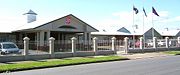
as there are no public schools in Angle Park. All three have around 300-400 students. There is a small shopping complex at the corner of Trafford and Wilson Streets, and the Parks Community Centre, provides a library, health centre, gym and fitness centre, swimming complex, council office, and a few other community services. A greyhound racing facility exists on the eastern side of the suburb, and it is also the site of a fire brigade unit and an ETSA Utilities
manufacturing plant where Stobie pole
s are assembled. It was also the site of the Parks High School, which was closed at the end of 1996, due to declining enrolments. Currently, the local zone high school is Croydon High School
, in Croydon
. However, a large number of the families in the area choose to send their children to other schools, mainly in the city centre, which was one of the causes of the closure of the Parks High School.
 Angle Park is home to a large immigrant population. The initial settlement of the suburb coincided with a large wave of immigrants from Eastern Europe arriving in Australia, following the Second World War. Although most of their children have moved on, a large number of immigrant retirees still live in the area. Another wave of immigration occurred in the 1980s, when Vietnamese immigrants arrived after the Vietnam War. Currently, more than 50% of the population is from a non-English speaking background.
. It is the most pro-Australian Labor Party
area in South Australia, recording the highest two-party-preferred vote in the state for the ALP at the Mansfield Park Primary School booth (the closest booth to Angle Park) at the 1998, 2001 and 2004 federal elections, garnering more than 80% on each occasion.
Suburb
The word suburb mostly refers to a residential area, either existing as part of a city or as a separate residential community within commuting distance of a city . Some suburbs have a degree of administrative autonomy, and most have lower population density than inner city neighborhoods...
of Adelaide
Adelaide
Adelaide is the capital city of South Australia and the fifth-largest city in Australia. Adelaide has an estimated population of more than 1.2 million...
10 km from the CBD
Central business district
A central business district is the commercial and often geographic heart of a city. In North America this part of a city is commonly referred to as "downtown" or "city center"...
, in the state of South Australia
South Australia
South Australia is a state of Australia in the southern central part of the country. It covers some of the most arid parts of the continent; with a total land area of , it is the fourth largest of Australia's six states and two territories.South Australia shares borders with all of the mainland...
, Australia
Australia
Australia , officially the Commonwealth of Australia, is a country in the Southern Hemisphere comprising the mainland of the Australian continent, the island of Tasmania, and numerous smaller islands in the Indian and Pacific Oceans. It is the world's sixth-largest country by total area...
and falls under the City of Port Adelaide Enfield
City of Port Adelaide Enfield
The City of Port Adelaide Enfield was established on 1 January 1997 by the amalgamation of the City of Port Adelaide and the City of Enfield, and is one of the larger metropolitan councils within South Australia....
. It is adjacent to Wingfield
Wingfield, South Australia
Wingfield is a suburb situated north of Adelaide and is located on Grand Junction Road. The suburb borders Gepps Cross and Dry Creek.- Government :The suburb of Wingfield is in the City of Port Adelaide Enfield local government area....
, Mansfield Park
Mansfield Park, South Australia
Mansfield Park is a north-western suburb of Adelaide 10 km from the CBD, in the state of South Australia, Australia and falls under the City of Port Adelaide Enfield. It is adjacent to Wingfield, Angle Park, Woodville Gardens, and Athol Park. The postcode for Mansfield Park is 5012. It is bounded...
, Ferryden Park
Ferryden Park, South Australia
Ferryden Park is a north-western suburb of Adelaide 9km from the central business district, in the state of South Australia, Australia. Situated in the City of Port Adelaide Enfield local government area, it is adjacent to Kilkenny, Angle Park, Woodville Gardens, Croydon Park, and Regency Park...
, and Regency Park
Regency Park, South Australia
Regency Park is an inner-northern suburb of Adelaide, 8km from the City Centre, in the state of South Australia, Australia. It is located in the City of Port Adelaide Enfield, and is adjacent to Wingfield, Angle Park, Ferryden Park, Kilburn, Prospect, Dudley Park and Croydon Park...
. The post code for Angle Park is 5010. It is bounded to the north by Grand Junction Road
Grand Junction Road, Adelaide
Grand Junction Road is the longest east-west thoroughfare in the Adelaide metropolitan area, and is located approximately 9 kilometres north of the city centre. Travelling from the Port Adelaide region, it is mostly a double lane sealed road running 21 kilometres to the base of the Adelaide Hills...
, west by Trafford Street, and to the east by Days and South Road
South Road, Adelaide
South Road is a major north–south conduit in Adelaide, South Australia. Also known as Main South Road, it is Adelaide's most important arterial road.- Route :...
.
History
Prior to the Second World War, Angle Park mainly consisted of pastures and open land. Its development as a residential area coincided with the post-war boom in the 1950s. It is home to a large number of houses owned by the South Australian Housing TrustSouth Australian Housing Trust
The South Australian Housing Trust was a statutory authority established by the of the Government of South Australia responsible for providing low-cost rental housing to working people and their families.-History:...
. However, in the eastern side of the suburb, there is a variety of light industry and warehouses.
In 1960, the Angle Park Boys Technical High School was constructed on what is now the Parks Community Centre, followed by the Angle Park Girls Technical High School the following year. They operated separately until 1977 when they combined to become the Angle Park High School. The complex was expanded in 1979 to become the Parks Community Centre in 1979, which included a council library, with the high school becoming known as the Parks High School.
In the 1990s, plans were made for the Westwood Urban Renewal project, of which Ferryden Park
Ferryden Park, South Australia
Ferryden Park is a north-western suburb of Adelaide 9km from the central business district, in the state of South Australia, Australia. Situated in the City of Port Adelaide Enfield local government area, it is adjacent to Kilkenny, Angle Park, Woodville Gardens, Croydon Park, and Regency Park...
, Mansfield Park
Mansfield Park, South Australia
Mansfield Park is a north-western suburb of Adelaide 10 km from the CBD, in the state of South Australia, Australia and falls under the City of Port Adelaide Enfield. It is adjacent to Wingfield, Angle Park, Woodville Gardens, and Athol Park. The postcode for Mansfield Park is 5012. It is bounded...
, Woodville Gardens
Woodville Gardens, South Australia
Woodville Gardens is a north-western suburb of Adelaide 10km from the CBD, in the state of South Australia, Australia and falls under the City of Port Adelaide Enfield. It is adjacent to Woodville North, Mansfield Park, Ferryden Park, and Kilkenny. The post code for Woodville Gardens is 5012...
, and Athol Park
Athol Park, South Australia
Athol Park is a north-western suburb of Adelaide, South Australia. It is located in the City of Charles Sturt.-Geography:The suburb lies at the western end of Grand Junction Road, which also forms its northern boundary...
are also a part. This involved the demolition of many of the Housing Trust homes, to be replaced by either private housing, or a lesser number of newer, townhouse-style housing trust homes. The building began in 2001, and as of 2004 and 2005, began to affect Angle Park.
Facilities
There are three primary schools in the area, being the public Mansfield Park Primary School, established in 1969, and the CatholicCatholic
The word catholic comes from the Greek phrase , meaning "on the whole," "according to the whole" or "in general", and is a combination of the Greek words meaning "about" and meaning "whole"...
St Patrick's School, both of which are in the adjacent Mansfield Park
Mansfield Park, South Australia
Mansfield Park is a north-western suburb of Adelaide 10 km from the CBD, in the state of South Australia, Australia and falls under the City of Port Adelaide Enfield. It is adjacent to Wingfield, Angle Park, Woodville Gardens, and Athol Park. The postcode for Mansfield Park is 5012. It is bounded...
, and the Ferryden Park Primary School
Ferryden Park Primary School
Ferryden Park Primary School was a primary school in the Adelaide inner north west suburb of Ferryden Park.In 1959 the student enrolment at the school peaked at 639 students, due in part to the post-war boom of the 1950s....
as there are no public schools in Angle Park. All three have around 300-400 students. There is a small shopping complex at the corner of Trafford and Wilson Streets, and the Parks Community Centre, provides a library, health centre, gym and fitness centre, swimming complex, council office, and a few other community services. A greyhound racing facility exists on the eastern side of the suburb, and it is also the site of a fire brigade unit and an ETSA Utilities
ETSA Utilities
ETSA Utilities is the operator of the South Australian electricity distribution network, delivering electricity from the high voltage transmission network connection points through a network of about 85,000 kilometres of powerlines, to over 782,000 residential and business customers throughout most...
manufacturing plant where Stobie pole
Stobie pole
A Stobie pole is a power line pole made of two steel joists held apart by a slab of concrete in the middle. It was invented by Adelaide Electricity Supply Company design engineer James Cyril Stobie . Stobie used materials easily at hand due to the shortage of suitably long, strong, straight and...
s are assembled. It was also the site of the Parks High School, which was closed at the end of 1996, due to declining enrolments. Currently, the local zone high school is Croydon High School
Croydon High School
Croydon High School for Girls GDST is a leading non-denominational independent school for girls, located near Croydon, Greater London, England. It is one of the schools in the Girls' Day School Trust....
, in Croydon
Croydon, South Australia
Croydon is an inner northern suburb of Adelaide, South Australia. It is located in the City of Charles Sturt.-History:The land on which the suburb now stands was purchased in 1853 by Alfred Watts and Philip Levi. They laid out the Village of Croydon in 1855, comprising Croydon Farm of and lots of...
. However, a large number of the families in the area choose to send their children to other schools, mainly in the city centre, which was one of the causes of the closure of the Parks High School.
Transport
Trafford Street is served by the 251(311) and 252(312) services, while the 239 & 250(316) serves Days and Grand Junction Road. The 361 serves Grand Junction Road.Demographics
Politics
Angle Park is located within the federal seat of Port AdelaideDivision of Port Adelaide
The Division of Port Adelaide is an Australian Electoral Division in the state of South Australia. It is located in the northern suburbs of Adelaide, covering the area around the Barker Inlet, part of the Gulf St Vincent. It stretches from St Kilda in the north down to Grange Road, and is roughly...
. It is the most pro-Australian Labor Party
Australian Labor Party
The Australian Labor Party is an Australian political party. It has been the governing party of the Commonwealth of Australia since the 2007 federal election. Julia Gillard is the party's federal parliamentary leader and Prime Minister of Australia...
area in South Australia, recording the highest two-party-preferred vote in the state for the ALP at the Mansfield Park Primary School booth (the closest booth to Angle Park) at the 1998, 2001 and 2004 federal elections, garnering more than 80% on each occasion.