
Alum Creek Lake
Encyclopedia

Reservoir
A reservoir , artificial lake or dam is used to store water.Reservoirs may be created in river valleys by the construction of a dam or may be built by excavation in the ground or by conventional construction techniques such as brickwork or cast concrete.The term reservoir may also be used to...
was built in 1974, covers 123 sq mi (318.57 km²) and has a maximum capacity of 134815 acre.ft.
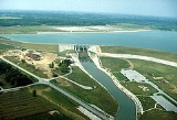
Dam Construction (1970 - 1974)
Alum Creek Dam which was constructed between 1970 and 1974 is located on Alum CreekAlum Creek
Alum Creek is long creek that runs north to south in central Ohio. The creek originates in Morrow County and then flows through Delaware County and finally into Franklin County, where it ends at Big Walnut Creek, which drains into the Scioto River. In 1974, the Army Corps of Engineers completed...
, a tributary of Big Walnut Creek
Big Walnut Creek
Big Walnut Creek starts near Mount Gilead, Ohio in Morrow County. It flows south to eastern Delaware County and parallels Alum Creek. It passes to the east of Sunbury and into Hoover Reservoir. The reservoir crosses into Franklin County and flows through Gahanna and Whitehall...
, which drains into the Scioto River
Scioto River
The Scioto River is a river in central and southern Ohio more than 231 miles in length. It rises in Auglaize County in west central Ohio, flows through Columbus, Ohio, where it collects its largest tributary, the Olentangy River, and meets the Ohio River at Portsmouth...
. The dam is a rolled earth-fill embankment 10000 ft (3,048 m) in length with a maximum height of 93 ft (28.3 m) The spillway is located high on the right abutment with the raceway dropping off in front of it to the stilling basin below. Control is provided by three 34 by 25 ft (7.6 m) tainter gate
Tainter gate
The Tainter gate is a type of radial arm floodgate used in dams and canal locks to control water flow. It is named for Wisconsin structural engineer Jeremiah Burnham Tainter....
s supported by 8 ft (2.4 m) wide concrete piers resting on concrete ogee sections. The ogee sections have a crest elevation of 878 and are founded at elevation 839.


Potential Dam Failure and Retrofit (1975-1978)
On April 24, 1975 during a periodic inspection of the completed dam, the US Army Corps of Engineers expressed concern about the safety of the spillway monoliths. The rock underlying the dam is Ohio Black Shale which is a largely hard, massive silt shale. It is highly fractured below the base of weathering. Within this shale are several light gray, silty to clayey shale seams up to 1 ft (0.3048 m) thick. It may be possible that the spillway monolith and its underlying bedrock could slide forward on one of these seams, opening a gap between the monolith and the rolled earth dam leading to rapid and catastrophic erosion of the dam.Testing
Twelve, 6-in. diameter core holes were drilled in the raceway directly in front of the ogee weirs. At least six of these cores exhibited a clayey seam about elevation 830 (nine feet below the ogee foundations). Testing of this material and deep-seated sliding analysis indicated that the dam did indeed face a safety issue.Retrofitting
To prevent the concrete monolith from sliding forward, it was decided to install seven cable anchors deep into the bedrock. Each anchor consisted of bundled, high strength steel cables that were concreted into the bottom of the holes. They were then hydraulically tensioned and the holes filled with grout. Achors were installed at a 45 degree angle to a depth of 813, or 26 feet (7.9 m) below the foundation of the ogees. On March 2, 1977 the project was bid to VSL Corporation for $254,777. Drilling for the anchors began on June 7, 1977. The final loading on each anchor was 1300 kips. On September 28, 1977, one of the anchor's foundations failed and had to be re-concreted. By 1978, the project was completed.The January, 2005 Flood
On January 16, 2005 Alum Creek Dam's reservoir reached its highest level since construction was completed in 1974, an elevation of 898.94, about 17 feet (5.2 m) above normal level. At this level control was maintained through the discharge pipe and it was not necessary to open the three main spillway gates.This extreme event was caused by an average of 5-8 inches of rain falling over Central Indiana and Ohio during January 4-14, 2005. This rain combined with snow melt and saturated ground to produce record breaking runoff. Other reservoirs also set pool level records, including Deer Creek, Delaware Lake, Paint Creek
Paint Creek (Ohio)
Paint Creek is a tributary of the Scioto River, 94.7 mi long, in south-central Ohio in the United States. Via the Scioto and Ohio Rivers, it is part of the watershed of the Mississippi River. It drains an area of 1,143 mi²...
, Atwood Lake
Atwood Lake
Atwood Lake is a reservoir located in Tuscarawas and Carroll counties in east central Ohio. The lake is formed by Atwood Dam across Indian Fork, a tributary of Conotton Creek . The lake is named for the community of Atwood which was purchased, demolished and inundated...
, Bolivar Dam, Charles Mill Lake
Charles Mill Lake
Charles Mill is a reservoir located in central Ohio near the junction of State Routes 430 and 603. Charles Mill Lake is a quiet and enjoyable place for boating, camping, fishing, hunting, or hiking. The lake is located in both Richland County and Ashland County , with the dam located in Ashland...
, Dillon Lake, Dover Dam, Mohawk Dam
Mohawk Dam
Mohawk Dam, located in Jefferson Township, Coshocton County, Ohio northwest of Nellie, is a dry dam constructed by the United States Army Corps of Engineers in the mid 1930s for the purpose of flood control on the Walhonding River. The dam is part of the larger 18-county Muskingum Watershed...
and Wills Creek
Wills Creek (Ohio)
Wills Creek is a tributary of the Muskingum River, 92.2 mi long, in eastern Ohio in the United States. Via the Muskingum and Ohio Rivers, it is part of the watershed of the Mississippi River. It drains an area of 853 mi² ....
.