

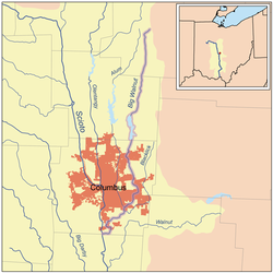
Big Walnut Creek
Encyclopedia
Mount Gilead, Ohio
Mount Gilead is a village in Morrow County, Ohio, United States.Mount Gilead's population was 3,290 at the 2000 census. It is the county seat of Morrow County and the center of population of Ohio. The village was established in 1832, eight years after white settlers arrived in the region...
in Morrow County
Morrow County, Ohio
Morrow County is a county located in the state of Ohio, United States. Shawnee people used the area for hunting purposes before white settlers arrived in the early 19th century. Morrow County was organized in 1848 from parts of four neighboring counties and named for Jeremiah Morrow, Governor of...
. It flows south to eastern Delaware County
Delaware County, Ohio
Delaware County is a fast-growing suburban county in the state of Ohio, United States, within the Columbus, Ohio Metropolitan Statistical Area. According to the United States Census Bureau's 2004 population estimates, Delaware County's population of 142,503 made it the fastest growing county in...
and parallels Alum Creek
Alum Creek
Alum Creek is long creek that runs north to south in central Ohio. The creek originates in Morrow County and then flows through Delaware County and finally into Franklin County, where it ends at Big Walnut Creek, which drains into the Scioto River. In 1974, the Army Corps of Engineers completed...
. It passes to the east of Sunbury
Sunbury, Ohio
Sunbury is a village in Delaware County, Ohio, United States. The population was 4,389 at the 2010 census. The village is centered around a New England-styled traditional town square with the historic village hall located in the center of a village green...
and into Hoover Reservoir
Hoover Dam (Ohio)
Hoover Dam, in Blendon Township, near Westerville, Ohio, dams the Big Walnut Creek to form the Hoover Memorial Reservoir. This reservoir is a major water source for the city of Columbus, Ohio. It holds of water and has a surface area of , or about five square miles. The dam was dedicated in...
. The reservoir crosses into Franklin County
Franklin County, Ohio
Franklin County is a county located in the state of Ohio, United States. In 2010 the population was 1,163,414, making it the second largest county in Ohio and the 34th largest county in population in the United States. Franklin County is also the largest in the eight-county Columbus, Ohio...
and flows through Gahanna
Gahanna, Ohio
As of the census of 2000, there were 32,636 people, 11,990 households, and 8,932 families residing in the city. The population density was 2,632.8 people per square mile . There were 12,390 housing units at an average density of 999.5 per square mile...
and Whitehall
Whitehall, Ohio
As of the census of 2000, there were 19,201 people, 8,343 households, and 4,930 families residing in the city. The population density was 3,681.9 people per square mile . There were 8,997 housing units at an average density of 1,725.2 per square mile...
. Near Obetz
Obetz, Ohio
Obetz is a village in Franklin County, Ohio, United States. The population was 3,977 at the 2000 census, and estimated to be 4,079 as of 2005. The community was formed in 1838 as a railroad junction, and incorporated in 1928.-Geography:...
it is joined by its principal tributaries Alum Creek
Alum Creek
Alum Creek is long creek that runs north to south in central Ohio. The creek originates in Morrow County and then flows through Delaware County and finally into Franklin County, where it ends at Big Walnut Creek, which drains into the Scioto River. In 1974, the Army Corps of Engineers completed...
and Blacklick Creek
Blacklick Creek (Ohio)
Blacklick Creek is a tributary stream of Big Walnut Creek in Ohio, flowing through Licking, Fairfield and Franklin counties. The creek's name was originally given by Native Americans, who had noticed the animals that frequented the creek to lick its black-colored salt stones...
at the Three Creeks Columbus Metro Park
Metro Parks (Columbus, Ohio)
The Metro Parks are a group of 15 metropolitan parks near Columbus, Ohio. They are officially organized as the "Columbus and Franklin County Metropolitan Park District". The Metro Parks system was organized in 1945 under Ohio Revised Code Section 1545 as a separate political division of the state...
. It flows through southern Franklin County and joins the Scioto River
Scioto River
The Scioto River is a river in central and southern Ohio more than 231 miles in length. It rises in Auglaize County in west central Ohio, flows through Columbus, Ohio, where it collects its largest tributary, the Olentangy River, and meets the Ohio River at Portsmouth...
near the Franklin-Pickaway
Pickaway County, Ohio
As of the census of 2000, there were 52,727 people, 17,599 households, and 13,287 families residing in the county. The population density was 105 people per square mile . There were 18,596 housing units at an average density of 37 per square mile...
Counties line.
Variant names
According to the Geographic Names Information SystemGeographic Names Information System
The Geographic Names Information System is a database that contains name and locative information about more than two million physical and cultural features located throughout the United States of America and its territories. It is a type of gazetteer...
, the Big Walnut Creek has also been known as:
- Big Belly Creek
- Big Bellys Creek
- Big Lick Creek
- Gahanna River
- Hayes Ditch
- Walnut Creek
- Whingwy Mahoni Sepung
- Menkwi Mhoani Siipunk