
Mohawk Dam
Encyclopedia
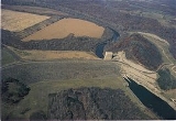
Mohawk Dam, located in Jefferson Township
, Coshocton County
, Ohio
northwest of Nellie
, is a dry dam
constructed by the United States Army Corps of Engineers
(USACE) in the mid 1930s for the purpose of flood control on the Walhonding River
. The dam is part of the larger 18-county Muskingum Watershed Conservancy District
(MWCD). The dam has been in service for 70 years and was recently placed on the USACE's "Urgent" dam safety classification list and plans are currently being drafted that would allocate funds for dam stabilization.
and was built as a dry dam along with 13 other dams in the Muskingum River
Watershed for flood control and water conservation. The dam was built right across the right-of-way of the Walhonding Canal
, which ran from Coshocton
to Cavallo.
The dam has always operated as a dry dam, holding back water only during a flood and releasing it slowly downstream. The highest water level ever recorded at the Mohawk Dam was during the flood of January 2005, where the water reached a height of 80.01 feet (24.4 m) above its normal level.
According to the MWCD, the dam's greatest problem is the inherent downstream seepage that occurs with most earthen dams. In the case of the Mohawk Dam, this condition is exacerbated by the fact that it was built on highly permeable
land, which could cause instability if too much water were to seep through the lower part of the dam. A rehabilitation and repair plan to stabilize the structure has not yet been established, nor has an official cost-estimate been prepared. Funds were set aside by Congress in 2006 and 2007 to analyze the current state of the dam and gather data for a rehabilitation report. The MWCD serves as the local sponsor of the rehabilitation projects and must pay 3.45 percent of the costs. The remainder will be paid by the federal government. In order to pay for their share, the MWCD will levy an assessment of the properties in its 18-county district, requiring those property owners to pay for the dam improvements throughout the entire watershed. The total local-share cost to be paid by the MWCD for the work on four of the dams, including the Mohawk Dam, is estimated to be between $95 million and $135 million.
Jefferson Township, Coshocton County, Ohio
Jefferson Township is one of the twenty-two townships of Coshocton County, Ohio, United States. The 2000 census found 1,549 people in the township, 634 of whom lived in the unincorporated portions of the township.-Geography:...
, Coshocton County
Coshocton County, Ohio
Coshocton County is a county located in the state of Ohio, United States. As of the 2010 census, the population was 36,901. Its county seat is Coshocton. Its name comes from the Delaware Indian language and has been translated as "union of waters" or "black bear crossing".The Coshocton...
, Ohio
Ohio
Ohio is a Midwestern state in the United States. The 34th largest state by area in the U.S.,it is the 7th‑most populous with over 11.5 million residents, containing several major American cities and seven metropolitan areas with populations of 500,000 or more.The state's capital is Columbus...
northwest of Nellie
Nellie, Ohio
Nellie is a village in Coshocton County, Ohio, United States, along the Walhonding River. The population was 134 at the 2000 census.The 1930s-era Mohawk Dam, a dry dam built for flood control, is just to the north and west of the village.-Geography:...
, is a dry dam
Dry dam
A dry dam is a dam constructed for the purpose of flood control. Dry dams typically contain no gates or turbines, and are intended to allow the channel to flow freely during normal conditions...
constructed by the United States Army Corps of Engineers
United States Army Corps of Engineers
The United States Army Corps of Engineers is a federal agency and a major Army command made up of some 38,000 civilian and military personnel, making it the world's largest public engineering, design and construction management agency...
(USACE) in the mid 1930s for the purpose of flood control on the Walhonding River
Walhonding River
The Walhonding River is a principal tributary of the Muskingum River, 23.5 miles long, in east-central Ohio in the United States. Via the Muskingum and Ohio Rivers, it is part of the watershed of the Mississippi River. It drains an area of 2,252 square miles .The Walhonding flows for its entire...
. The dam is part of the larger 18-county Muskingum Watershed Conservancy District
Muskingum Watershed Conservancy District
The Muskingum Watershed Conservancy District is a political subdivision of the State of Ohio organized in 1933 to develop and implement a plan for flood reduction and water conservation in the Muskingum River Watershed, the state's largest wholly contained watershed, covering more than...
(MWCD). The dam has been in service for 70 years and was recently placed on the USACE's "Urgent" dam safety classification list and plans are currently being drafted that would allocate funds for dam stabilization.
History
Construction of the Mohawk Dam was started in April 1935 and was completed in September 1937. The dam was authorized by the Flood Control Act of 1938Flood Control Act of 1938
The Flood Control Act of 1938 was an Act of the United States Congress signed into law by President Franklin Delano Roosevelt that authorized civil engineering projects such as dams, levees, dikes, and other flood control measures through the United States Army Corps of Engineers and other Federal...
and was built as a dry dam along with 13 other dams in the Muskingum River
Muskingum River
The Muskingum River is a tributary of the Ohio River, approximately 111 miles long, in southeastern Ohio in the United States. An important commercial route in the 19th century, it flows generally southward through the eastern hill country of Ohio...
Watershed for flood control and water conservation. The dam was built right across the right-of-way of the Walhonding Canal
Walhonding Canal
The Walhonding Canal was a canal in Coshocton County, Ohio that was used as a feeder canal for the Ohio and Erie Canal. A small canal, at only long, it was wholly contained within Coshocton County, following the Mohican River from Cavallo south to the confluence with the Kokosing River, which...
, which ran from Coshocton
Coshocton, Ohio
Coshocton is a city in and the county seat of Coshocton County, Ohio, United States. The population of the city was 11,682 at the 2000 census. The Walhonding River and the Tuscarawas River meet in Coshocton to form the Muskingum River....
to Cavallo.
The dam has always operated as a dry dam, holding back water only during a flood and releasing it slowly downstream. The highest water level ever recorded at the Mohawk Dam was during the flood of January 2005, where the water reached a height of 80.01 feet (24.4 m) above its normal level.
Future
The dam has been in service for 70 years but was only built with the expectation that it would function for around 50 years before sedimentation and erosion weakened the dam. The dam has weakened and several safety issues have arisen, which is why the USACE has placed it on its list of the nation's most at-risk dams, where it ranked seventh most at-risk in 2006. In 2007, the dam was classified as "Urgent", which is the second-highest classification level of the dam safety rating system used by the USACE. This classification indicates that the dam is a high federal priority for repairs since failure of the dam during a flood is moderately uncertain. The MWCD estimates that if the Mohawk Dam were to fail during a flood, the water normally held back could cost 307 people their lives and up to $449 million in property damage.According to the MWCD, the dam's greatest problem is the inherent downstream seepage that occurs with most earthen dams. In the case of the Mohawk Dam, this condition is exacerbated by the fact that it was built on highly permeable
Permeability (fluid)
Permeability in fluid mechanics and the earth sciences is a measure of the ability of a porous material to allow fluids to pass through it.- Units :...
land, which could cause instability if too much water were to seep through the lower part of the dam. A rehabilitation and repair plan to stabilize the structure has not yet been established, nor has an official cost-estimate been prepared. Funds were set aside by Congress in 2006 and 2007 to analyze the current state of the dam and gather data for a rehabilitation report. The MWCD serves as the local sponsor of the rehabilitation projects and must pay 3.45 percent of the costs. The remainder will be paid by the federal government. In order to pay for their share, the MWCD will levy an assessment of the properties in its 18-county district, requiring those property owners to pay for the dam improvements throughout the entire watershed. The total local-share cost to be paid by the MWCD for the work on four of the dams, including the Mohawk Dam, is estimated to be between $95 million and $135 million.