

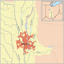
Alum Creek
Encyclopedia
Ohio
Ohio is a Midwestern state in the United States. The 34th largest state by area in the U.S.,it is the 7th‑most populous with over 11.5 million residents, containing several major American cities and seven metropolitan areas with populations of 500,000 or more.The state's capital is Columbus...
. The creek originates in Morrow County
Morrow County, Ohio
Morrow County is a county located in the state of Ohio, United States. Shawnee people used the area for hunting purposes before white settlers arrived in the early 19th century. Morrow County was organized in 1848 from parts of four neighboring counties and named for Jeremiah Morrow, Governor of...
and then flows through Delaware County
Delaware County, Ohio
Delaware County is a fast-growing suburban county in the state of Ohio, United States, within the Columbus, Ohio Metropolitan Statistical Area. According to the United States Census Bureau's 2004 population estimates, Delaware County's population of 142,503 made it the fastest growing county in...
and finally into Franklin County
Franklin County, Ohio
Franklin County is a county located in the state of Ohio, United States. In 2010 the population was 1,163,414, making it the second largest county in Ohio and the 34th largest county in population in the United States. Franklin County is also the largest in the eight-county Columbus, Ohio...
, where it ends at Big Walnut Creek
Big Walnut Creek
Big Walnut Creek starts near Mount Gilead, Ohio in Morrow County. It flows south to eastern Delaware County and parallels Alum Creek. It passes to the east of Sunbury and into Hoover Reservoir. The reservoir crosses into Franklin County and flows through Gahanna and Whitehall...
, which drains into the Scioto River
Scioto River
The Scioto River is a river in central and southern Ohio more than 231 miles in length. It rises in Auglaize County in west central Ohio, flows through Columbus, Ohio, where it collects its largest tributary, the Olentangy River, and meets the Ohio River at Portsmouth...
. In 1974, the Army Corps of Engineers completed the Alum Creek Reservoir near the middle portion of the creek length. This reservoir "has a surface area of 3,387 acres of water and was created to ensure a water supply
Water supply
Water supply is the provision of water by public utilities, commercial organisations, community endeavours or by individuals, usually via a system of pumps and pipes...
for the city of Columbus, provide flood control
Flood control
In communications, flood control is a feature of many communication protocols designed to prevent overwhelming of a destination receiver. Such controls can be implemented either in software or in hardware, and will often request that the message be resent after the receiver has finished...
for the area south of the reservoir, and yield recreational opportunities."
History
The Alum Creek valley was inhabited by the AdenaAdena culture
The Adena culture was a Pre-Columbian Native American culture that existed from 1000 to 200 BC, in a time known as the early Woodland Period. The Adena culture refers to what were probably a number of related Native American societies sharing a burial complex and ceremonial system...
over 2,000 years ago. This mound builder culture constructed seven mounds along Alum Creek. The Lenape (Delaware)
Lenape
The Lenape are an Algonquian group of Native Americans of the Northeastern Woodlands. They are also called Delaware Indians. As a result of the American Revolutionary War and later Indian removals from the eastern United States, today the main groups live in Canada, where they are enrolled in the...
Indian tribe later established many settlements near the creek.
One of the first European settlers was Colonel Moses Byxbe, who constructed his home on Alum Creek in 1805. Colonel Byxbe owned or co-owned 38,000 acres (150 km²) along the creek.
As a defensive measure during the War of 1812
War of 1812
The War of 1812 was a military conflict fought between the forces of the United States of America and those of the British Empire. The Americans declared war in 1812 for several reasons, including trade restrictions because of Britain's ongoing war with France, impressment of American merchant...
, local residents built four blockhouses in the area, including one on Alum Creek. The blockhouse, Fort Cheshire, was a 2-storey log fortress, constructed so as to provide a place from which to shoot, drop boiling water, and defend against the threat of fire. The blockhouse was subsequently used as a schoolhouse and remained intact until the Civil War
American Civil War
The American Civil War was a civil war fought in the United States of America. In response to the election of Abraham Lincoln as President of the United States, 11 southern slave states declared their secession from the United States and formed the Confederate States of America ; the other 25...
. The fort is commemorated by a bronze plaque where the blockhouse once stood.
Underground Railroad
The history of Alum Creek is also notable for its connection to the Underground RailroadUnderground Railroad
The Underground Railroad was an informal network of secret routes and safe houses used by 19th-century black slaves in the United States to escape to free states and Canada with the aid of abolitionists and allies who were sympathetic to their cause. The term is also applied to the abolitionists,...
, by which many slaves found their freedom. The Underground Railroad's Sycamore Trail ran along Alum Creek. Africa Road, near Alum Creek, is so named because of the nearby settlement of thirty freed slaves from North Carolina.
Alum Creek Lake
Near 40°10′36"N 082°57′24"W Elevation: 833 feet (253.9 m)Alum Creek Lake Dam
Near 40°10′36"N 082°57′24"W Elevation: 833 feet (253.9 m)Drinking Water
Alum Creek is a source of drinking water for the city of Westerville, OhioWesterville, Ohio
Westerville, once known as "The Dry Capital of the World", is a city in Franklin and Delaware counties in the U.S. state of Ohio. The population was 35,318 at the 2000 census.-Early history:...
.