

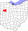
Lima, Ohio metropolitan area
Encyclopedia
United States Census Bureau
The United States Census Bureau is the government agency that is responsible for the United States Census. It also gathers other national demographic and economic data...
, is an area consisting of one county – Allen
Allen County, Ohio
Allen County is a county located in the U.S. state of Ohio. Its population was 106,331 as of the 2010 census. It is included in the Lima, Ohio Metropolitan Statistical Area as well as the Lima–Van Wert–Wapakoneta Combined Statistical Area....
– in Northwest
Northwest Ohio
Northwest or northwestern Ohio consists of multiple counties in the northwestern corner of the US state of Ohio. This area borders Lake Erie, southern Michigan, and eastern Indiana. Some areas in northwestern Ohio are also considered the Black Swamp area. The Toledo metropolitan area is also part...
Ohio
Ohio
Ohio is a Midwestern state in the United States. The 34th largest state by area in the U.S.,it is the 7th‑most populous with over 11.5 million residents, containing several major American cities and seven metropolitan areas with populations of 500,000 or more.The state's capital is Columbus...
, anchored by the city of Lima
Lima, Ohio
Lima is a city in and the county seat of Allen County, Ohio, United States. The municipality is located in northwestern Ohio along Interstate 75 approximately north of Dayton and south-southwest of Toledo....
. As of the 2000 census
United States Census, 2000
The Twenty-second United States Census, known as Census 2000 and conducted by the Census Bureau, determined the resident population of the United States on April 1, 2000, to be 281,421,906, an increase of 13.2% over the 248,709,873 persons enumerated during the 1990 Census...
, the MSA had a population of 108,473 (though a July 1, 2009 estimate placed the population at 104,357).
History
The Lima metropolitan area was first defined in 1950. Then known as the Lima Standard Metropolitan Area (Lima SMA), it consisted of a single county – Allen – and had a population of 88,183. Following a term change by the Bureau of the Budget (present-day Office of Management and Budget) in 1959, the Lima SMA became the Lima Standard Metropolitan Statistical Area (Lima SMSA). By the censusUnited States Census
The United States Census is a decennial census mandated by the United States Constitution. The population is enumerated every 10 years and the results are used to allocate Congressional seats , electoral votes, and government program funding. The United States Census Bureau The United States Census...
of 1960
United States Census, 1960
The Eighteenth United States Census, conducted by the Census Bureau, determined the resident population of the United States to be 179,323,175, an increase of 18.5 percent over the 151,325,798 persons enumerated during the 1950 Census.-Census questions:...
, the population had grown to 103,691, a 18 percent increase over the previous census.
Two additional counties were added to the Lima SMSA in 1971 – Putnam
Putnam County, Ohio
Putnam County is a county located in the state of Ohio, United States. As of the 2010 census, the population was 34,499. The name is in honor of Israel Putnam, who was a hero in the French and Indian War and a general in the American Revolutionary War. Its county seat is...
and Van Wert. Auglaize County became a part of the SMSA in 1973. With that addition, there were a total of 218,244 residents living in the metropolitan area at the 1980 census
United States Census, 1980
The Twentieth United States Census, conducted by the Census Bureau, determined the resident population of the United States to be 226,545,805, an increase of 11.4 percent over the 203,184,772 persons enumerated during the 1970 Census.-Census questions:...
.
In 1983, the official name was shortened to the Lima Metropolitan Statistical Area (Lima MSA), which is still in use to date. That same year, Putnam and Van Wert counties were removed from the MSA, leaving only Allen and Auglaize counties in the defined area. The two-county Lima MSA had a population of 154,340 in 1990
United States Census, 1990
The Twenty-first United States Census, conducted by the Census Bureau, determined the resident population of the United States to be 248,709,873, an increase of 9.8 percent over the 226,545,805 persons enumerated during the 1980 Census....
. That figure had risen to 155,084 by 2000
United States Census, 2000
The Twenty-second United States Census, known as Census 2000 and conducted by the Census Bureau, determined the resident population of the United States on April 1, 2000, to be 281,421,906, an increase of 13.2% over the 248,709,873 persons enumerated during the 1990 Census...
.
In 2003, Auglaize County was removed from the Lima metropolitan area and was re-designated as the Wapakoneta
Wapakoneta, Ohio
Wapakoneta is a city in and the county seat of Auglaize County, Ohio, United States with a population of 9,474 as of the 2000 U.S. census. It is the principal city of and is included in the Wapakoneta, Ohio Micropolitan S A, which is included in the Lima-Van Wert-Wapakoneta, Ohio CSA...
Micropolitan Statistical Area (Wapakoneta μSA).
Villages
|
Fort Shawnee, Ohio Fort Shawnee is a village in Allen County, Ohio, United States with a population of 3,855 as of the 2000 U.S. census. It is included in the Lima, Ohio Metropolitan Statistical Area... Harrod, Ohio Harrod is a village in Allen County, Ohio, United States with a population of 491 as of the 2000 U.S. census. It is included in the Lima, Ohio Metropolitan Statistical Area.-Geography:Harrod is located at .... Lafayette, Ohio Lafayette is a village in Allen County, Ohio, United States with a population of 304 as of the 2000 U.S. census. It is included in the Lima, Ohio Metropolitan Statistical Area.-Geography:Lafayette is located at .... Spencerville, Ohio Spencerville is a village in Allen County, Ohio, United States with a population of 2,235 as of the 2000 U.S. census. It is included in the Lima, Ohio Metropolitan Statistical Area.-Geography:Spencerville is located at .... |
Townships
|
Monroe Township, Allen County, Ohio Monroe Township is one of the twelve townships of Allen County, Ohio, United States. The 2000 census found 2,219 people in the township, 1,720 of whom lived in the unincorporated portions of the township.-Geography:... Perry Township, Allen County, Ohio Perry Township is one of the twelve townships of Allen County, Ohio, United States. The 2000 census found 3,620 people in the unincorporated parts of the township.-Geography:Located in the southern part of the county, it borders the following townships:... Richland Township, Allen County, Ohio Richland Township is one of the twelve townships of Allen County, Ohio, United States. The 2000 census found 6,090 people in the township, 2,015 of whom lived in the unincorporated portions of the township.-Geography:... Shawnee Township, Allen County, Ohio Shawnee Township is one of the twelve townships of Allen County, Ohio, United States. The 2000 census found 12,220 people in the township, 8,365 of whom lived in the unincorporated portions of the township.-Geography:... Spencer Township, Allen County, Ohio Spencer Township is one of the twelve townships of Allen County, Ohio, United States. The 2000 census found 3,106 people in the township, 871 of whom lived in the unincorporated portions of the township.-Geography:... Sugar Creek Township, Allen County, Ohio Sugar Creek Township is one of the twelve townships of Allen County, Ohio, United States. The 2000 census found 1,330 people in the township.-Geography:Located in the northern part of the county, it borders the following townships:... |
Combined Statistical Area
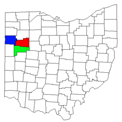
The Lima–Van Wert
Van Wert, Ohio
As of the census of 2000, there were 10,690 people, 4,556 households, and 2,947 families residing in the city. The population density was 1,803.8 people per square mile . There were 4,927 housing units at an average density of 831.4 per square mile...
–Wapakoneta
Wapakoneta, Ohio
Wapakoneta is a city in and the county seat of Auglaize County, Ohio, United States with a population of 9,474 as of the 2000 U.S. census. It is the principal city of and is included in the Wapakoneta, Ohio Micropolitan S A, which is included in the Lima-Van Wert-Wapakoneta, Ohio CSA...
Combined Statistical Area is made up of three counties in northwest Ohio. The statistical area includes one metropolitan area
United States metropolitan area
In the United States a metropolitan statistical area is a geographical region with a relatively high population density at its core and close economic ties throughout the area. Such regions are not legally incorporated as a city or town would be, nor are they legal administrative divisions like...
and two micropolitan areas
United States micropolitan area
United States Micropolitan Statistical Areas , as defined by the United States Office of Management and Budget, are urban areas in the United States based around a core city or town with a population of 10,000 to 49,999. The micropolitan area designation was created in 2003...
. As of the 2000 Census, the CSA had a population of 184,743 (though a July 1, 2009 estimate placed the population at 179,552).
- Metropolitan Statistical Areas (MSAs)
- Lima (Allen County)
- Micropolitan Statistical Areas (μSAs)
- Van Wert (Van Wert County)
- Wapakoneta (Auglaize CountyAuglaize County, OhioAs of the census of 2000, there were 46,611 people, 17,376 households, and 12,771 families residing in the county. The population density was 116 people per square mile . There were 18,470 housing units at an average density of 46 per square mile...
)