

Adelaide Park Lands
Encyclopedia
Park
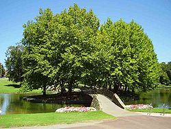
A park is a protected area, in its natural or semi-natural state, or planted, and set aside for human recreation and enjoyment, or for the protection of wildlife or natural habitats. It may consist of rocks, soil, water, flora and fauna and grass areas. Many parks are legally protected by...
s that surround the centre
Adelaide city centre
The Adelaide city centre is the innermost locality of Greater Adelaide, known by locals simply as "The City" or "Town". The locality is split into two key geographical distinctions: the city "square mile", bordered by North, East, South and West Terraces; and that part of the Adelaide Parklands...
of the South Australia
South Australia
South Australia is a state of Australia in the southern central part of the country. It covers some of the most arid parts of the continent; with a total land area of , it is the fourth largest of Australia's six states and two territories.South Australia shares borders with all of the mainland...
n capital city of Adelaide
Adelaide
Adelaide is the capital city of South Australia and the fifth-largest city in Australia. Adelaide has an estimated population of more than 1.2 million...
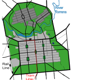
. They measure approximately 7.6 square kilometres in a green belt
Green belt
A green belt or greenbelt is a policy and land use designation used in land use planning to retain areas of largely undeveloped, wild, or agricultural land surrounding or neighbouring urban areas. Similar concepts are greenways or green wedges which have a linear character and may run through an...
encircling the city centre.
The parklands were laid out by Colonel William Light
William Light
Colonel William Light was a British military officer and the first Surveyor-General of the Colony of South Australia...
in his design for the city. Originally, Light reserved 9.31 km² for parklands, but allocated around 1.53 km² for government purposes. This area has largely been filled with cultural institutions along North Terrace
North Terrace, Adelaide
North Terrace is one of the four terraces that bound the central business and residential district of the city of Adelaide, the capital city of South Australia. It runs east-west, along the northern edge of the CBD.-North Side of North Terrace:...
, but further and additional areas have been alienated for railways, cemeteries, sporting facilities and other constructions. The parklands are managed by the Adelaide City Council
City of Adelaide
The City of Adelaide is a local government area in the metropolitan area of Adelaide, South Australia. It covers the original Adelaide city centre settlement, , North Adelaide, and the Adelaide Park Lands which surround North Adelaide and the city centre.Established in 1840, the organisation now...
and, since February 2007, the Adelaide Park Lands Authority.
On 7 November 2008 the Federal Minister for Environment, Heritage and the Arts, Peter Garrett
Peter Garrett
Peter Robert Garrett, AM, MP , is an Australian musician, environmentalist, activist and politician.Garrett was lead singer of the Australian rock band Midnight Oil from 1973 until its disbanding in 2002...
, announced that the Adelaide Park Lands had been entered in the Australian National Heritage List
Australian National Heritage List
The Australian National Heritage List is a list of places deemed to be of outstanding heritage significance to Australia. The list includes natural, historic and indigenous places...
as "an enduring treasure for the people of South Australia and the nation as a whole".
History
William Light
Colonel William Light was a British military officer and the first Surveyor-General of the Colony of South Australia...
's 1837 plan. Light chose a site next to the River Torrens
River Torrens
The River Torrens is the most significant river of the Adelaide Plains and was one of the reasons for the siting of the city of Adelaide, capital of South Australia. It flows from its source in the Adelaide Hills near Mount Pleasant, across the Adelaide Plains, past the city centre and empties...
, (which runs through the park lands), and planned the city centre on a grid south of the river, with the residential enclave of North Adelaide
North Adelaide
North Adelaide is a predominantly residential precinct of the City of Adelaide in South Australia, situated north of the River Torrens and within the Adelaide Park Lands.-History:...
north of the Torrens on a gentle hill overlooking the river, its flood plain, and the central business district
Central business district
A central business district is the commercial and often geographic heart of a city. In North America this part of a city is commonly referred to as "downtown" or "city center"...
. Influenced by William Penn
William Penn
William Penn was an English real estate entrepreneur, philosopher, and founder of the Province of Pennsylvania, the English North American colony and the future Commonwealth of Pennsylvania. He was an early champion of democracy and religious freedom, notable for his good relations and successful...
's design of Philadelphia, Light set out the city of Adelaide on a grid of one square mile, interspaced by wide boulevards and incorporating five large public squares. Light, recognising the importance of public parks, surrounded the entire city with the Adelaide Park Lands, a green-belt and the "lungs of the city".
By 1839 the parklands were threatened by extensive timber cutting, rubbish dumping, quarrying, squatting, and grazing. To check this, a body of special constable
Special constable
A Special Constable is a law enforcement officer who is not a regular member of a police force. Some like the Royal Canadian Mounted Police carry the same law enforcement powers as regular members, but are employed in specific roles, such as explosive disposal technicians, court security, campus...
s was instituted on 9 October 1839 by George Gawler
George Gawler
-External links: – Memorials and Monuments in Portsmouth, Hampshire, UK...
and Superintendent Henry Inman
Henry Inman (police commander)
Henry Inman , cavalry officer, Pioneer of South Australia, founder and first commander of the South Australia Police, overlander, Anglican clergyman.-Origins:...
. Inman appointed Nick Boys Bull (c.1800-1846), formerly a police sub-inspector, as Keeper of the Parklands. Bull led an initial team of six park rangers, most being convalescent migrants thrown on government support. This dropped to two by 1840, then back to four by June 1841. Pay and rations were provided by the police department.
Since 1852, the parklands have been managed and maintained by the Adelaide City Council. Public use of the parklands was controlled by a ranger who patrolled the parks, regulating sporting and recreational activities in the parks and supervising the depasturing of stock grazing there.
The parklands saw very little development during the 19th century. Extensive felling of trees, quarrying and dumping of rubbish continued, which combined to give the parklands an unsightly appearance. In the late 19th century J.E. Brown, the government's Conservator of Forests, was commissioned by the City Council to prepare a blueprint for the beautification of the parklands. Brown presented his report in 1880, but it was not acted upon until the turn of the 20th century when A.W. Pelzer became the City Gardener. Major progress was made in planting and landscaping the parklands during his tenure (1899–1932) and further improvements such as creation of new gardens and boating lakes were carried under the authority of W.C.D. Veale, the Town Clerk (1947–1965).
Parklands today
Today, some of the parklands are the location of public and cultural buildings. Many parts have been sculpted into planned gardens and playing fields. Some of the remainder is natural or regenerated Adelaide PlainsAdelaide Plains
The Adelaide Plains is the area in South Australia between the Mount Lofty Ranges on the east and Gulf St Vincent on the west. The plains are generally fertile with annual rainfall of about per year....
bushland. Recent developments in the parklands have focused on maintenance and upgrading of recreational facilities, particularly through the Greening of Adelaide tree planting and replacement programs.
Recent years have seen proposals made to redevelop Victoria Park, with the construction of a grandstand to cater for the Clipsal 500 and horse racing events. Due to lobbying by local resident groups this plan was eventually rejected by the Adelaide City Council and subsequently no longer pursued by the South Australian Government.
Parks
The roadways crossing through the parklands define the separate parks, all of which are numbered (from "Park 1" through "Park 29"). The numbering starts at the northern end of the Parkland (the North Course of the Adelaide Golf Links), and increases clockwise around the perimeter. Most of the parks are more commonly known by a commemorative name, but some, particularly Park 10
Park 10, Adelaide
Park 10 is a parkland in the city of Adelaide, South Australia. It is one of the few parks in the Adelaide Parklands to still be known most commonly by its assigned number, and is enclosed by McKinnon Parade, Bundey's Road, War Memorial Drive and Frome Road...
, are still known mostly by their number. In recent years, many parks were assigned alternative names as suggested by the indigenous Kaurna people. However, the original English names assigned in the 19th century remain almost universally used.
Park 1
Kaurna Park Name & translation: Piltawodli 'possum place' 76 hectaresOf an irregular shape, Park 1 wraps around the western end of North Adelaide
North Adelaide
North Adelaide is a predominantly residential precinct of the City of Adelaide in South Australia, situated north of the River Torrens and within the Adelaide Park Lands.-History:...
in a vaguely crescent or banana shape. The southern and western boundaries are provided by War Memorial Drive. The eastern boundary, from south to north, is formed by Montefiore Rd, the western end of North Adelaide (i.e. Strangways Tce, Mills Tce and Barton Tce West) and Jeffcott Rd. The northern boundary is formed by Park Tce.
Contains the Adelaide Golf Links.
Park 2
Padipadinyilla 'swimming place' 17 hectaresApproximately square, the park is bounded by Fitzroy Tce (to the north), Prospect Rd (to the east), Barton Tce West (to the south) and Jeffcott Rd (to the west).
The Park provides a range of formal and informal facilities for cricket, swimming, tennis and family picnics. The north-west corner of the Park contains the Adelaide Aquatic Centre
Adelaide Aquatic Centre
The Adelaide Aquatic Centre is a complex of indoor heated swimming pools operated by the Adelaide City Council and located in the northernmost extent of the Adelaide Parklands...
, picnic facilities and the Bush Magic playground. The remainder of the Park includes sporting facilities, open space and vegetation (designed and semi-natural landscapes).
- The Adelaide Swimming Centre was relocated to this Park in 1968/9 to replace the old City Baths on the current site of the Festival Centre. Renovated, enclosed and renamed Adelaide Aquatic Centre in 1985. Renovated again in 1998.
- The Bush Magic Play Park was designed in 1988, and is important as a precedent for the contemporary generation of play spaces around the Park Lands and metropolitan Adelaide. It was the first play park in SA to incorporate wheelchair access.
- Sporting facilities currently held under an annual licence to Blackfriars Priory School include change rooms, five playing fields and four tennis courts. The licence covers an area of approximately 35% of the Park. The school has first right of use of these areas on weekday afternoons after school, and on Saturday mornings.
Park 3
Kandarilla 'kandara root place' 3.3 hectaresA small triangle bounded by Prospect Rd (west), Fitzroy Tce (north) and Main North Rd (east).
Contains open park.
Park 4
Kangattilla 'kangatta berry place' 9.4 hectaresApproximately pentagonal, bounded by O'Connell St (west), Main North Rd (north-west), Lefevre Rd (north-east and east) and Barton Tce East (south).
Contains open and wooded park, with SA Water facilities at the western end. The former Fitzroy Croquet Club was located in the northern corner of the Park, and there were two ovals in the middle of the Park. The main structure of the SA Water facilities is an earth-covered reservoir, dating from the 1870s, that stored and supplied water to Adelaide. Associated with this are a two-storey red brick pumping station, a small brick pumping station "heavily painted in Brunswick green", and an electricity sub-station.
Park 5
Ngampa yerta 'ngampa root ground'Of irregular shape, the park is bounded by Robe Terrace (NE), Medindie Road (SE), Lefevre Road (W) and Main North Road (NW).
Contains two small ovals, surrounded by wooded park. There is also a Tree Planting Memorial, erected in 1982 by the North Adelaide Society, to recognise the community tree planting efforts in the locality.
Park 6
Nanto Womma 'horse plain' or 'male grey kangaroo plain'Roughly trapeziodal, the park is bounded by Robe Terrace (NNE), Kingston Terrace (SE), Lefevre Terrace (WSW) and Medindie Road (NW).
Contains open park, mainly used for horse grazing. There are three main paddocks, four feeding yards, five horse troughs, and a number of sandpits for the horses to roll in. There is a limit of 20 horses, and those licensed pay a weekly fee. (In 2005, the fee was $19.50 per week.)
The open areas are surrounded by woodland. There is a playground on the western boundary (Lefevre Tce), one of the Glover Playgrounds originally built in 1920, which also contains BBQ facilities and wide lawn spaces. The eastern third contains assorted playing fields, changing rooms, tennis courts and netball courts. Wilderness School holds a licence for eight tennis courts (also marked for netball), one cricket oval, two cricket practice nets, and three hockey/softball ovals. In 2005, there was also a green-painted brick structure with a flat roof, erected in the late 1960s, which "appears to have an undefined purpose and use".
Parks 7 and 8
Kuntingga 'kunti root place' (park 7) and Barnguttilla 'barngutta root place' (park 8) are small and elongated parks, with a combined area of 4.7 hectares, separating the east end of lower North Adelaide from GilbertonGilberton, South Australia
Gilberton is a suburb of Adelaide, South Australia on the northern bank of the River Torrens a short distance from Adelaide’s city centre. It is bounded by the river, Park terrace, Stephen Terrace and Northcote Terrace. The suburb is largely residential with some large and ornate Victorian homes...
, and contain heritage listed olive
Olive
The olive , Olea europaea), is a species of a small tree in the family Oleaceae, native to the coastal areas of the eastern Mediterranean Basin as well as northern Iran at the south end of the Caspian Sea.Its fruit, also called the olive, is of major agricultural importance in the...
groves. They act effectively as an enlarged median strip, with the major ring route of Park Terrace (southbound) and Mann Road (northbound) traversing the perimeter of both parks.
These parks were one of the first sites for the (European settlers) plantings of olives, and are the only section of the Park Lands that have kept the same use since the Council took over formal care of the Park Lands in the 1860s. The olive plantation is listed as a State Heritage Place.
Park 9
Tidlangga 'tidla root place'A triangular shape, bounded by Mackinnon Parade (NE), Bundeys Road (S) and Hackney Road (W). It has also been referred to as "Bundey's Paddock".
Contains assorted playing fields and changing rooms. An oval is licensed to Prince Alfred College
Prince Alfred College
Prince Alfred College is an independent, day and boarding school for boys, located on Dequetteville Terrace, Kent Town, near the centre of Adelaide, South Australia...
on Saturday afternoons and Thursday evenings. In the past, contained a number of grass and bitumen tennis courts which have fallen into dis-repair and been removed.
Park 10
Warnpangga 'bullrush root place' 19 hectaresBounded by War Memorial Drive, Bundey’s Road, MacKinnon Road, MacKinnon Parade, Finnis and Frome Road.
The Park is dominated by a number of sporting ovals and associated facilities licensed to the University of Adelaide, including a tennis pavilion, a grandstand, and changing rooms.
The Park also contains:
- The Adelaide Archery Club rooms, in the north eastern corner of the Park.
- The University Loop, a well used 2.2 km gravel running track, which encircles part of the Park.
- The Adelaide City Council Organic Recycling Depot/Nursery, (approx 1.6 hectares), comprising: an Office Building, 3 sheds, 6 glass houses, a shade house, and 6 propagating plant frames.
- The Lower North Adelaide Soldiers’ Memorial Garden, located in the north of the Park.
- A number of sculptures, located in 1994 on the edge of the River Torrens.
- A small playground
Park 11
Tainmundilla, 'mistletoe place'A quite large piece of land bounded by the River Torrens
River Torrens
The River Torrens is the most significant river of the Adelaide Plains and was one of the reasons for the siting of the city of Adelaide, capital of South Australia. It flows from its source in the Adelaide Hills near Mount Pleasant, across the Adelaide Plains, past the city centre and empties...
(north), North Terrace (south), Hackney Rd (east) and Frome Rd
Frome Road, Adelaide
Frome Road is a connecting road in the South Australian capital city of Adelaide. It starts from North Terrace in the Adelaide city centre, running in a northerly direction past the University of South Australia, the Royal Adelaide Hospital, the Institute of Medical and Veterinary Science and the...
(west). It contains the Zoological Gardens
Adelaide Zoo
Adelaide Zoo is Australia's second oldest zoo, and the only major metropolitan zoo in Australia to be owned and operated on a non-profit basis. It is located in the parklands just north of the city centre of Adelaide, South Australia. It is a full institutional member of the Zoo and Aquarium...
, the Botanic Gardens
Adelaide Botanic Garden
The Adelaide Botanic Garden is a public garden at the north-east corner of the Adelaide city centre, in the Adelaide Park Lands. It encompasses a fenced garden on North Terrace and behind it the Botanic Park...
, the Botanic Park
Botanic Park, Adelaide
Botanic Park, which is a part of Park 11 and also known by its Kaurna name Tainmundilla, is a 34 hectare park in the Northeast Parklands of the South Australian capital of Adelaide. It is bordered by Hackney and Frome Roads. The park abuts the Adelaide Zoo and River Torrens on its northern side...
, the Wine Centre
National Wine Centre of Australia
The National Wine Centre of Australia is a public exhibition building about winemaking and its industry in South Australia. It contains an interactive permanent exhibition of winemaking, introducing visitors to the technology, varieties and styles of wine...
, the Royal Adelaide Hospital
Royal Adelaide Hospital
The Royal Adelaide Hospital is Adelaide's largest hospital, with 680 beds. Founded in 1840, the Royal Adelaide provides tertiary health care services for South Australia and provides secondary care clinical services to residents of Adelaide's city centre and inner suburbs.The hospital is situated...
(RAH), the Institute of Medical and Veterinary Science
Institute of Medical and Veterinary Science
Established in 1938, is a wholly South Australian medically-led network of pathology laboratories, providing the people of metropolitan and rural South Australia with comprehensive quality pathology and integrated clinical services....
(IMVS), the Medical School of the University of Adelaide
University of Adelaide
The University of Adelaide is a public university located in Adelaide, South Australia. Established in 1874, it is the third oldest university in Australia...
, and several University of South Australia
University of South Australia
The University of South Australia is a public university in the Australian state of South Australia. It was formed in 1991 with the merger of the South Australian Institute of Technology and Colleges of Advanced Education. It is the largest university in South Australia, with more than 36,000...
buildings.
Park 12
Karrawirra 'river red gum forest'Bisected by the river, the northern part contains the University playing fields. The southern part contains the University of South Australia
University of South Australia
The University of South Australia is a public university in the Australian state of South Australia. It was formed in 1991 with the merger of the South Australian Institute of Technology and Colleges of Advanced Education. It is the largest university in South Australia, with more than 36,000...
(City East campus), the University of Adelaide
University of Adelaide
The University of Adelaide is a public university located in Adelaide, South Australia. Established in 1874, it is the third oldest university in Australia...
(main campus), the Art Gallery
Art Gallery of South Australia
The Art Gallery of South Australia , located on the cultural boulevard of North Terrace in Adelaide, is the premier visual arts museum in the Australian state of South Australia. It has a collection of over 35,000 works of art, making it, after the National Gallery of Victoria, the largest state...
, the Museum
South Australian Museum
The South Australian Museum is a museum in Adelaide, South Australia, founded in 1856. It occupies a complex of buildings on North Terrace in the cultural precinct of the Adelaide Parklands.-History:...
, the State Library
State Library of South Australia
The State Library of South Australia, located on North Terrace, Adelaide, is the official library of the Australian state of South Australia. It is the largest public research library in the state with a collection focus on South Australian information, and general reference material for...
, the War Memorial
National War Memorial (South Australia)
The National War Memorial is a monument in the South Australian capital of Adelaide, commemorating those who served in the First World War. Opened in 1931, the memorial is located on the corner of North Terrace and Kintore Avenue, in the heart of the central business district and adjacent to the...
, Government House
Government House, Adelaide
Government House, located in Adelaide on the corner of North Terrace and King William Road, is the official residence of the Governor of South Australia.-History:The original 'Government Hut' was a thatched hut constructed by the seamen of the HMS Buffalo...
, the Torrens Parade Ground
Torrens Parade Ground
Torrens Parade Ground is situated by the River Torrens in Adelaide, South Australia.It is the location of South Australia's Vietnam War Memorial.-External links:*...
, Jolly's Boat House, the Boer War Memorial
South African War Memorial (South Australia)
The South African War Memorial is an equestrian memorial dedicated to the South Australians who served in the Second Boer War of 11 October 1899 to 31 May 1902...
, the Jubilee 150 Walkway
Jubilee 150 Walkway
The Jubilee 150 Walkway, also variously known as the Jubilee 150 Commemorative Walk, the Jubilee 150 Walk, and the Jubilee Walk, is a series of 150 bronze plaques set into the pavement of North Terrace, Adelaide. It was officially opened on 21 December 1986...
, numerous statues, and quite a lot of other odds and ends.
Park 13
Kadlitpinna - named after Kaurna "Elder" painted by George French AngasGeorge French Angas
George French Angas , was an English explorer, naturalist and painter.He was born in Newcastle upon Tyne, England, the eldest son of George Fife Angas, prominent in the establishment of the new colony of South Australia. Despite showing remarkable talent in drawing, he was placed in a London...
Park 14
Mullawirraburka - named after Kaurna "King" of the Aldinga-Willunga areaPark 15
Ityamaiitpinna - one of the three main Kaurna "Elders" with whom the colonists negotiatedPark 16
Bakkabakkandi Used to contain Victoria Park Racecourse.Contains part of the Adelaide Street Circuit
Adelaide Street Circuit
The Adelaide Street Circuit is a temporary street circuit in the East Parklands adjacent to the central business district of the city of Adelaide in South Australia....
, et al.
Park 17
http://www.adelaidecitycouncil.com/community/reconciliation/kaurna/place-naming/sign-site-17.html Contains the Croque Club, et al.Park 18
http://www.adelaidecitycouncil.com/community/reconciliation/kaurna/place-naming/sign-site-18.html Contains Himeji Gardens et al.Park 19
http://www.adelaidecitycouncil.com/community/reconciliation/kaurna/place-naming/sign-site-19.html Open park and playing fields.Park 20
http://www.adelaidecitycouncil.com/community/reconciliation/kaurna/place-naming/sign-site-20.html Contains the French Club and Boule rinks, assorted playing fields, a mountain-bike / BMX-bike track, et al.Park 21
http://www.adelaidecitycouncil.com/community/reconciliation/kaurna/place-naming/sign-site-21.html Contains Veale GardensVeale Gardens
Veale Gardens is part of the Adelaide Parklands throughout and surrounding the City of Adelaide, and is located in the South Parklands surrounded by Greenhill and Peacock Roads, South Terrace, and Sir Lewis Cohen Avenue...
, assorted playing fields, et al.
Park 22
http://www.adelaidecitycouncil.com/community/reconciliation/kaurna/place-naming/sign-site-22.html Contains about 40 netball courts, et al.Park 23
http://www.adelaidecitycouncil.com/community/reconciliation/kaurna/place-naming/sign-site-23.html Contains West Terrace CemeteryWest Terrace Cemetery
The West Terrace Cemetery is South Australia’s oldest cemetery, first appearing on Colonel William Light’s 1837 plan of Adelaide. The 27.6 hectare site is located in the south-west corner of the Adelaide central business district, between West Terrace, Anzac Highway, Sir Donald Bradman Drive and...
, et al.
Park 24
http://www.adelaidecitycouncil.com/community/reconciliation/kaurna/place-naming/sign-site-24.html Contains Adelaide High SchoolAdelaide High School
Adelaide High School is a coeducational state high school situated on the corner of West Terrace and Glover Avenue in the Adelaide Parklands. It is the first government high school in South Australia...
and assorted sports grounds
Park 25
http://www.adelaidecitycouncil.com/community/reconciliation/kaurna/place-naming/sign-site-25.html Contains assorted sports grounds, and until demolished in November 2010, some SA WaterSA Water
SA Water was established by the proclamation of the South Australian Water Corporation Act 1994 on 1 July 1995. Its predecessor was known as Engineering and Water Supply Department . E&WS evolved from the Waterworks and Drainage Commission, which was established in 1856...
buildings in the north-west corner on the far side of the railway line.
Park 26
http://www.adelaidecitycouncil.com/community/reconciliation/kaurna/place-naming/sign-site-26.html Like Park 12, it is bisected by the river. The northern part contains the Adelaide OvalAdelaide Oval
The Adelaide Oval is a sports ground in Adelaide, South Australia, located in the parklands between the Central Business District and North Adelaide...
, Memorial Drive
Memorial Drive Park
Memorial Drive Park, more generally referred to as "Memorial Drive", is a tennis venue, located adjacent to the Adelaide Oval, in the park lands surrounding the centre of Adelaide, South Australia...
, St Peter's Cathedral
St Peter's Cathedral, Adelaide
St Peter's Cathedral is an Anglican Cathedral in the South Australian capital of Adelaide. It is the seat of the Bishop of the Anglican Diocese of Adelaide...
and Light's Vision
Light's Vision
The first surveyor-general of Adelaide, South Australia, Colonel William Light designed a layout and development programme for the city. This plan is now known as "Light's Vision"...
. The southern part contains Parliament House
Parliament House, Adelaide
Parliament House, on the corner of North Terrace and King William Road in Adelaide city centre, is the seat of the Parliament of South Australia. It was built to replace the adjacent and overcrowded Parliament House, now referred to as "Old Parliament House"...
, Old Parliament House, Adelaide Railway Station
Adelaide Railway Station
Adelaide Railway Station is the central terminus of the Adelaide Metro railway system. It is at on the north side of North Terrace, west of Parliament House. The Adelaide Casino is in part of the building that is no longer required for the station....
, the Casino, the Riverbank development, the Convention Centre
Adelaide Convention Centre
The Adelaide Convention Centre is a large convention centre on North Terrace, Adelaide, Australia. It was the first purpose-built convention centre to be built in Australia....
, assorted boat houses, the Festival Centre
Adelaide Festival Centre
The Adelaide Festival Centre, Australia's first multi-purpose arts centre, was built in 1973 and opened three months before the Sydney Opera House. The Festival Centre is located approximately 50 metres north of the corner of North Terrace and King William Street, lying near the banks of the River...
and Elder Park
Park 27
http://www.adelaidecitycouncil.com/community/reconciliation/kaurna/place-naming/sign-site-27.html A large irregular shaped park bounded by the tram line (south, south-west, west), Park Tce (north-west), Memorial Drive (north-east, east, north-east, north) and the Morphett St Bridge (east), and bisected by the River Torrens.It contains the Torrens Weir, restaurant and Par 3 putting course, the Dame Roma Mitchell Gardens, the Old Adelaide Gaol
Adelaide Gaol
Adelaide Gaol was an Australian prison located in Thebarton, South Australia, Australia. The gaol was the first permanent one in South Australia and operated from 1841 until 1988...
, the Bonython Park, the Police Barracks, the Road Safety School the Railway Yards (soon to be relocated to Dry Creek), assorted broad gauge and standard gauge railway lines and bridges, the proposed site of the relocated Royal Adelaide Hospital, City Sk8 Park, six Tennis Courts, some boat houses and Rowing Clubs' clubhouses, a car park (leased by TransAdelaide to the Casino), etc.
Park 28
http://www.adelaidecitycouncil.com/community/reconciliation/kaurna/place-naming/sign-site-28.htmlPark 29
http://www.adelaidecitycouncil.com/community/reconciliation/kaurna/place-naming/sign-site-29.html Brougham Gardens are surrounded by Brougham Place, North AdelaideBrougham Place, North Adelaide
Brougham Place is a street lined with large mansions set in landscaped grounds in the Adelaide suburb of North Adelaide, South Australia. It surrounds Brougham Gardens, , that joins the three grids that comprise North Adelaide. It was named after Henry Brougham, 1st Baron Brougham and Vaux...
.
Planned parks
Other parks are the location for institutions requiring large expanses of turf or other greenery. Planned parks such as these include:- Adelaide Botanic Gardens (Park 11)
- Adelaide Botanic Park (Park 11)
- Adelaide High SchoolAdelaide High SchoolAdelaide High School is a coeducational state high school situated on the corner of West Terrace and Glover Avenue in the Adelaide Parklands. It is the first government high school in South Australia...
's sports grounds (Park 24) - Adelaide Municipal Golf Links (Park 1)
- Victoria Park Racecourse (Park 16)
- Adelaide Street CircuitAdelaide Street CircuitThe Adelaide Street Circuit is a temporary street circuit in the East Parklands adjacent to the central business district of the city of Adelaide in South Australia....
(Surrounding Parks 14 & 15, and inside Park 16) - Adelaide OvalAdelaide OvalThe Adelaide Oval is a sports ground in Adelaide, South Australia, located in the parklands between the Central Business District and North Adelaide...
(Park 26) - Elder Park (Park 26)
- Himeji GardensHimeji Gardens, AdelaideThe Adelaide Himeji Gardens in the south parklands was a gift from Adelaide's sister city, Himeji, in 1982. The entrance is from South Terrace, between Pulteney and Hutt Streets.The enclosure is one of only a few classical Japanese gardens in Adelaide...
(Park 18) - Veale GardensVeale GardensVeale Gardens is part of the Adelaide Parklands throughout and surrounding the City of Adelaide, and is located in the South Parklands surrounded by Greenhill and Peacock Roads, South Terrace, and Sir Lewis Cohen Avenue...
(Park 21)
Buildings/institutions within bounds of parklands
- Adelaide Aquatic CentreAdelaide Aquatic CentreThe Adelaide Aquatic Centre is a complex of indoor heated swimming pools operated by the Adelaide City Council and located in the northernmost extent of the Adelaide Parklands...
(Park 2) - Adelaide Botanic GardenAdelaide Botanic GardenThe Adelaide Botanic Garden is a public garden at the north-east corner of the Adelaide city centre, in the Adelaide Park Lands. It encompasses a fenced garden on North Terrace and behind it the Botanic Park...
* (Park 11) - Adelaide Convention CentreAdelaide Convention CentreThe Adelaide Convention Centre is a large convention centre on North Terrace, Adelaide, Australia. It was the first purpose-built convention centre to be built in Australia....
* (Park 26) - Adelaide Festival CentreAdelaide Festival CentreThe Adelaide Festival Centre, Australia's first multi-purpose arts centre, was built in 1973 and opened three months before the Sydney Opera House. The Festival Centre is located approximately 50 metres north of the corner of North Terrace and King William Street, lying near the banks of the River...
(Park 26) - Adelaide High SchoolAdelaide High SchoolAdelaide High School is a coeducational state high school situated on the corner of West Terrace and Glover Avenue in the Adelaide Parklands. It is the first government high school in South Australia...
(Park 24) - Adelaide OvalAdelaide OvalThe Adelaide Oval is a sports ground in Adelaide, South Australia, located in the parklands between the Central Business District and North Adelaide...
(Park 26) - Adelaide Parklands Terminal (Park 23)
- Adelaide Railway StationAdelaide Railway StationAdelaide Railway Station is the central terminus of the Adelaide Metro railway system. It is at on the north side of North Terrace, west of Parliament House. The Adelaide Casino is in part of the building that is no longer required for the station....
* (Park 26) - Adelaide University Boat ClubAdelaide University Boat ClubThe Adelaide University Boat Club is a rowing club affiliated with the University of Adelaide. The club was founded in 1881, and in 1896 helped to form the Adelaide University Sports Association. The main clubrooms, donated by Robert Barr Smith in 1909, are located on the north bank of the River...
(Park 12) - Adelaide ZooAdelaide ZooAdelaide Zoo is Australia's second oldest zoo, and the only major metropolitan zoo in Australia to be owned and operated on a non-profit basis. It is located in the parklands just north of the city centre of Adelaide, South Australia. It is a full institutional member of the Zoo and Aquarium...
(Park 11) - Art Gallery of South AustraliaArt Gallery of South AustraliaThe Art Gallery of South Australia , located on the cultural boulevard of North Terrace in Adelaide, is the premier visual arts museum in the Australian state of South Australia. It has a collection of over 35,000 works of art, making it, after the National Gallery of Victoria, the largest state...
* (Park 12) - Government HouseGovernment House, AdelaideGovernment House, located in Adelaide on the corner of North Terrace and King William Road, is the official residence of the Governor of South Australia.-History:The original 'Government Hut' was a thatched hut constructed by the seamen of the HMS Buffalo...
* (Park 12) - Institute of Medical and Veterinary ScienceInstitute of Medical and Veterinary ScienceEstablished in 1938, is a wholly South Australian medically-led network of pathology laboratories, providing the people of metropolitan and rural South Australia with comprehensive quality pathology and integrated clinical services....
(Park 11) - Memorial DriveMemorial Drive ParkMemorial Drive Park, more generally referred to as "Memorial Drive", is a tennis venue, located adjacent to the Adelaide Oval, in the park lands surrounding the centre of Adelaide, South Australia...
(Park 26) - National War MemorialNational War Memorial (South Australia)The National War Memorial is a monument in the South Australian capital of Adelaide, commemorating those who served in the First World War. Opened in 1931, the memorial is located on the corner of North Terrace and Kintore Avenue, in the heart of the central business district and adjacent to the...
* (Park 12) - National Wine Centre (Park 11)
- Parliament HouseParliament House, AdelaideParliament House, on the corner of North Terrace and King William Road in Adelaide city centre, is the seat of the Parliament of South Australia. It was built to replace the adjacent and overcrowded Parliament House, now referred to as "Old Parliament House"...
* (Park 26) - Royal Adelaide HospitalRoyal Adelaide HospitalThe Royal Adelaide Hospital is Adelaide's largest hospital, with 680 beds. Founded in 1840, the Royal Adelaide provides tertiary health care services for South Australia and provides secondary care clinical services to residents of Adelaide's city centre and inner suburbs.The hospital is situated...
* (Park 11) - South Australian MuseumSouth Australian MuseumThe South Australian Museum is a museum in Adelaide, South Australia, founded in 1856. It occupies a complex of buildings on North Terrace in the cultural precinct of the Adelaide Parklands.-History:...
* (Park 12) - State Library of South AustraliaState Library of South AustraliaThe State Library of South Australia, located on North Terrace, Adelaide, is the official library of the Australian state of South Australia. It is the largest public research library in the state with a collection focus on South Australian information, and general reference material for...
* (Park 12) - University of AdelaideUniversity of AdelaideThe University of Adelaide is a public university located in Adelaide, South Australia. Established in 1874, it is the third oldest university in Australia...
City (main) campus* (Park 12) - University of South AustraliaUniversity of South AustraliaThe University of South Australia is a public university in the Australian state of South Australia. It was formed in 1991 with the merger of the South Australian Institute of Technology and Colleges of Advanced Education. It is the largest university in South Australia, with more than 36,000...
City East campus* (Park 12)
North Terrace, Adelaide
North Terrace is one of the four terraces that bound the central business and residential district of the city of Adelaide, the capital city of South Australia. It runs east-west, along the northern edge of the CBD.-North Side of North Terrace:...
forms the southern boundary of these establishments.
Parkland preservation movement
Since the parklands were intended by the city founders to be reserved for parks, any development can be seen to go against the founding ambitions for Adelaide and be a source of controversy in the community.In response to incessant pressure and erosion, in the 1987 a public meeting was held, which resulted in the formation of the Adelaide Parklands Preservation Association Inc, (APPA). Examples of such pressure and erosion are listed on APPA's "Hot Topics" page.
A recent example of one such source of controversy is the Victoria Park
Victoria Park, Adelaide
Victoria Park, also known as Park 16, is a park located in the Southeastern Parklands of the South Australian capital of Adelaide. It is bordered by Fullarton Road, Greenhill Road, East Terrace and Wakefield Road...
racecourse and associated parklands south-east of the city centre which has been used for motor racing events for short periods of each year. In 2008 these parklands were targeted for development, incurring opposition from members of the community. The proposed plans included construction of a permanent facility to house events such as the Adelaide 500
Adelaide 500
The Adelaide 500 is an annual motor racing event for V8 Supercars, held on the streets of the east end of Adelaide, South Australia on a shortened form of the Adelaide Street Circuit, the former Australian Grand Prix track...
motor racing event.
On 30 August 2007 veteran Adelaide heritage consultant and conservation architect Ron Danvers said it was "a myth" that Adelaide's founding fathers created the parklands exclusively for open space, and that it was "self-evident" that Colonel William Light's 1837 plan of Adelaide envisaged development of facilities beyond the CBD. In a submission to the Adelaide City Council, Mr Danvers said the state Government's $55 million plan for a grandstand at Victoria Park for horse and motor racing was "completely consistent with the founding principles for the city". "Under Light's direction, the intention to locate public facilities outside of the main street grid is beyond question," he said in a report commissioned by developers KBR.
Subsequently, numerous counter-arguments demonstrated the falacies in those points of view, and the proposal was dropped.
External links
- Park Lands Usage, City of Adelaide fact sheet no.9, March 2009, www.adelaidecitycouncil.com