
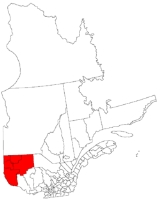
Abitibi-Témiscamingue
Encyclopedia

Quebec
Quebec or is a province in east-central Canada. It is the only Canadian province with a predominantly French-speaking population and the only one whose sole official language is French at the provincial level....
, Canada
Canada
Canada is a North American country consisting of ten provinces and three territories. Located in the northern part of the continent, it extends from the Atlantic Ocean in the east to the Pacific Ocean in the west, and northward into the Arctic Ocean...
, along the border with Ontario
Ontario
Ontario is a province of Canada, located in east-central Canada. It is Canada's most populous province and second largest in total area. It is home to the nation's most populous city, Toronto, and the nation's capital, Ottawa....
. It became part of the province in 1898. It has a land area of 57,674.26 km2 (22,268.16 sq mi). As of the 2006 census
Statistics Canada
Statistics Canada is the Canadian federal government agency commissioned with producing statistics to help better understand Canada, its population, resources, economy, society, and culture. Its headquarters is in Ottawa....
, the population of the region was 143,872 inhabitants.
History
The land was first occupied about 8,000 years ago by the Algonquins. The first land expeditions were made in 1670 by RadissonPierre-Esprit Radisson
Pierre-Esprit Radisson was a French-Canadian fur trader and explorer. He is often linked to his brother-in-law Médard des Groseilliers who was about 20 years older. The decision of Radisson and Groseilliers to enter the English service led to the formation of the Hudson's Bay Company.Born near...
as part of the development of the fur trade
Fur trade
The fur trade is a worldwide industry dealing in the acquisition and sale of animal fur. Since the establishment of world market for in the early modern period furs of boreal, polar and cold temperate mammalian animals have been the most valued...
industry across the Hudson Bay
Hudson Bay
Hudson Bay , sometimes called Hudson's Bay, is a large body of saltwater in northeastern Canada. It drains a very large area, about , that includes parts of Ontario, Quebec, Saskatchewan, Alberta, most of Manitoba, southeastern Nunavut, as well as parts of North Dakota, South Dakota, Minnesota,...
region and through most of the New France
New France
New France was the area colonized by France in North America during a period beginning with the exploration of the Saint Lawrence River by Jacques Cartier in 1534 and ending with the cession of New France to Spain and Great Britain in 1763...
colony. Fort Témiscamingue
Fort Témiscamingue
Fort Témiscamingue was a trading post from the 17th century in Duhamel-Ouest, Quebec, near Ville-Marie, Canada, located on the fur trade route on the east shore of Lake Timiskaming...
, located on the east banks of Lake Timiskaming
Lake Timiskaming
Lake Timiskaming is a large freshwater lake on the provincial border between Ontario and Quebec, Canada. The lake, which forms part of the Ottawa River, is in length and covers an area of almost . Its water level ranges between and above sea-level, with a mean annual average of . The lake is...
and erected by a French merchant on Anicinabeg lands in 1720, was an important crossroads of the fur trade along the Hudson Bay trading route.
Until 1868, Abitibi was owned by the Hudson's Bay Company
Hudson's Bay Company
The Hudson's Bay Company , abbreviated HBC, or "The Bay" is the oldest commercial corporation in North America and one of the oldest in the world. A fur trading business for much of its existence, today Hudson's Bay Company owns and operates retail stores throughout Canada...
; it was then purchased by Canada and became part of the North-West Territories
Northwest Territories
The Northwest Territories is a federal territory of Canada.Located in northern Canada, the territory borders Canada's two other territories, Yukon to the west and Nunavut to the east, and three provinces: British Columbia to the southwest, and Alberta and Saskatchewan to the south...
. After negotiations with the federal government of Sir Wilfrid Laurier
Wilfrid Laurier
Sir Wilfrid Laurier, GCMG, PC, KC, baptized Henri-Charles-Wilfrid Laurier was the seventh Prime Minister of Canada from 11 July 1896 to 6 October 1911....
, Abitibi was annexed to the province of Quebec on June 13, 1898 by a federal decree. For its part, Témiscamingue had been part of Lower Canada
Lower Canada
The Province of Lower Canada was a British colony on the lower Saint Lawrence River and the shores of the Gulf of Saint Lawrence...
and so was already part of Quebec at Confederation.
The region started to develop during the late 19th and early 20th century, with the development of agriculture and forest industries. This began in the southern areas, leading to the foundation of Ville-Marie
Ville-Marie, Quebec
Ville-Marie is a town on Lake Temiscaming in western Quebec, Canada. It is the largest city and seat of the Témiscamingue Regional County Municipality, Quebec. As one of the oldest towns in the Abitibi-Témiscamingue region, it is considered the cradle of north-western Quebec and nicknamed "Pearl of...
in 1886 and Témiscaming
Témiscaming, Quebec
Témiscaming is a town located at the south end of Lac Témiscamingue on the upper Ottawa River in the Témiscamingue Regional County Municipality of western Quebec, Canada. Also nearby is Lake Kipawa.-History:...
in 1918. However, the greatest wave of colonization occurred between World War I
World War I
World War I , which was predominantly called the World War or the Great War from its occurrence until 1939, and the First World War or World War I thereafter, was a major war centred in Europe that began on 28 July 1914 and lasted until 11 November 1918...
and World War II
World War II
World War II, or the Second World War , was a global conflict lasting from 1939 to 1945, involving most of the world's nations—including all of the great powers—eventually forming two opposing military alliances: the Allies and the Axis...
when a large population came from urban centres due to the effects of the Great Depression
Great Depression
The Great Depression was a severe worldwide economic depression in the decade preceding World War II. The timing of the Great Depression varied across nations, but in most countries it started in about 1929 and lasted until the late 1930s or early 1940s...
. In the 30s, federal and provincial plans such as the Plan Vautrin and the Plan Gordon incited jobless residents to move to undeveloped regions of the province, igniting the beginning of the second colonization flow.
The first migration flow brought people to the northern part of the region along the National Transcontinental Railway
National Transcontinental Railway
The National Transcontinental Railway was a historic Canadian railway between Winnipeg and Moncton. Much of the line is now operated by the Canadian National Railway.-The Grand Trunk partnership:...
, leading to the establishment of towns such as La Sarre
La Sarre, Quebec
La Sarre is a town in northwestern Quebec, Canada, and is the most populous town and seat of the Abitibi-Ouest Regional County Municipality. It is located at the intersection of Routes 111 and 393, on the La Sarre River, a tributary of Lake Abitibi....
in 1917 and Amos
Amos, Quebec
Amos is a ville in northwestern Quebec, Canada, on the Harricana River. It is the seat of Abitibi Regional County Municipality.Amos is the main city on the Harricana River, and the smallest of the three primary cities — after Rouyn-Noranda and Val-d'Or — in the Abitibi-Témiscamingue region of Quebec...
in 1914, as well as other infrastructure as the internment camp at Spirit Lake for so-called enemy aliens arrested under the War Measures Act
War Measures Act
The War Measures Act was a Canadian statute that allowed the government to assume sweeping emergency powers in the event of "war, invasion or insurrection, real or apprehended"...
during World War I.
The mining
Mining
Mining is the extraction of valuable minerals or other geological materials from the earth, from an ore body, vein or seam. The term also includes the removal of soil. Materials recovered by mining include base metals, precious metals, iron, uranium, coal, diamonds, limestone, oil shale, rock...
industry, mainly extracting gold
Gold
Gold is a chemical element with the symbol Au and an atomic number of 79. Gold is a dense, soft, shiny, malleable and ductile metal. Pure gold has a bright yellow color and luster traditionally considered attractive, which it maintains without oxidizing in air or water. Chemically, gold is a...
and copper
Copper
Copper is a chemical element with the symbol Cu and atomic number 29. It is a ductile metal with very high thermal and electrical conductivity. Pure copper is soft and malleable; an exposed surface has a reddish-orange tarnish...
, also contributed to the growth of the region when numerous mines were opened. New cities were created, such as Rouyn-Noranda in 1926 and Val-d'Or in 1934, and mining is still the backbone of the region's economy nowadays, along with forestry and agriculture.
Geography
The Abitibi-Témiscamingue region is the fourth largest region of the province after the Nord-du-QuébecNord-du-Québec
Nord-du-Québec is the largest of the seventeen administrative regions of Quebec, Canada. With , of which are lakes and rivers, it covers much of the Labrador Peninsula and about 55% of the total land surface area of Quebec....
, Côte-Nord
Côte-Nord
Côte-Nord is the second largest administrative region by land area in Quebec, Canada, after Nord-du-Québec...
and Saguenay-Lac-Saint-Jean
Saguenay-Lac-Saint-Jean
Saguenay–Lac-Saint-Jean is a region in Quebec, Canada. It contains the Saguenay Fjord, the estuary of the Saguenay River, stretching through much of the region...
regions. It has a total area of 65,000 km2. Its largest cities are Rouyn-Noranda and Val-d'Or.
The region's landscape features mixed forest to the south across the Témiscamingue area while boreal forest covers the northern section.
The region, like more southerly regions, has a continental humid climate, but has much higher temperature variations due to its latitude and its proximity to Hudson Bay
Hudson Bay
Hudson Bay , sometimes called Hudson's Bay, is a large body of saltwater in northeastern Canada. It drains a very large area, about , that includes parts of Ontario, Quebec, Saskatchewan, Alberta, most of Manitoba, southeastern Nunavut, as well as parts of North Dakota, South Dakota, Minnesota,...
and the Arctic.
National park
Aiguebelle National ParkAiguebelle National Park
Aiguebelle National Park is a national park of Quebec, Canada. It is located in western Quebec in the Abitibi-Témiscamingue region, west of Amos, Quebec and east of Kirkland Lake, Ontario.-External links:* - official site...
, the only national park of the region, is located in the centre of the Abitibian region and intents to protect natural heritage.
Economy
The region's workforce has one of the highest percentages in the primary sector of any region of Quebec, with near one out of six employees working in that sector. The miningMining
Mining is the extraction of valuable minerals or other geological materials from the earth, from an ore body, vein or seam. The term also includes the removal of soil. Materials recovered by mining include base metals, precious metals, iron, uranium, coal, diamonds, limestone, oil shale, rock...
sector is the most important economic activity of the region. Despite recent declines in workforce, the agriculture
Agriculture
Agriculture is the cultivation of animals, plants, fungi and other life forms for food, fiber, and other products used to sustain life. Agriculture was the key implement in the rise of sedentary human civilization, whereby farming of domesticated species created food surpluses that nurtured the...
and forest
Forest
A forest, also referred to as a wood or the woods, is an area with a high density of trees. As with cities, depending where you are in the world, what is considered a forest may vary significantly in size and have various classification according to how and what of the forest is composed...
industries still contribute significantly to the region's economy.
Economic activities are mainly dedicated to exportation products, and are even closely linked to the Middle North region in its development through hydroelectrical and mining projects, and through exchanges with First Nation northern communities.
Sportive tourism, including winter sports, fishing, hunting and cycling competition, is also a significant economic sector even if negligible by comparison with industrial sector.
University
The region is home to one university: UQAT - the Université du Québec en Abitibi-TémiscamingueUniversité du Québec en Abitibi-Témiscamingue
The Université du Québec en Abitibi-Témiscamingue, sometimes informally known as UQAT, is a public university within the Université du Québec network, with campuses in Val-d'Or and Rouyn-Noranda.-Mission:...
, which is part of the Quebec public university network. UQAT has its main campus at Rouyn-Noranda, a campus dedicated to the first nations at Val-d'Or and several branches in different cities of the region.
College
The only college in the region is the CégepCégep
CEGEP is an acronym for , which is literally translated as "College of General and Vocational Education" but commonly called "General and Vocational College" in circles not influenced by Quebec English. It refers to the public post-secondary education collegiate institutions exclusive to the...
de l'Abitibi-Témiscamingue, which has campuses in Amos, Rouyn-Noranda and Val-d'Or, and centres for continuing education in Ville-Marie and La Sarre.
Architecture and urban planning
Because of its history and its development, the regional urban planning and the architectural landscape is quite rich in contrasts, showing two main typologies of development.Rural and agricultural settlement
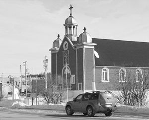
The agricultural development of northern Abitibi and the northern part of Témiscamingue by a relatively homogeneous population of French Canadian Catholic settlers has introduced a mainly rural land development. There, small towns, gravitating around a low density node generally composed of a wooden Roman Catholic church, an elementary school and few houses spread over the territory, according to an orthogonal division on the land, with rectangular parcels. Those small towns are gravitating themselves around a larger city, as La Sarre, Amos, Macamic and Ville-Marie, where major institutional equipments are established. If small towns might seem more or less vernacular, major cities are often more planned and influenced by Anglo-Saxon urban planning, with sometime an orthogonal grid with lane network.Because of their central location, main architectural elements are also on those cities. For instance, the Cathedral of Sainte-Thérèse d'Avila in Amos is one of the most outstanding architectural element of the region by its size and its Romano-Byzantine style, standing on the upper part of the city, and being at a symbolic central location of the region. However, if the cityscapes are often more various, the rural landscape features more local particularities. The wooden farms and barns built according to many vernacular forms, the fieldstone churches and the wooden houses with locally so-called “Canadian Roof” (steep roof ending with long curved overhang covering a front balcony) are widespread.
Boomtowns and industrial cities
The cities of Southern Abitibi and the city of TémiscamingTémiscaming, Quebec
Témiscaming is a town located at the south end of Lac Témiscamingue on the upper Ottawa River in the Témiscamingue Regional County Municipality of western Quebec, Canada. Also nearby is Lake Kipawa.-History:...
were established later and for industrial concerns, and follow a quite different organization. As they grew up often very quickly, the urban planning of these industrial cities is often eclectic. The initial boroughs of Val-d’Or and Rouyn-Noranda, for instance, are both built according to two different schemes; an industrial and planned borough built and planned by the mine, and a “boomtown
Boomtown
A boomtown is a community that experiences sudden and rapid population and economic growth. The growth is normally attributed to the nearby discovery of a precious resource such as gold, silver, or oil, although the term can also be applied to communities growing very rapidly for different reasons,...
” borough built suddenly with minimal planning for the thousands of people who arrived attracted by the effervescence of the gold rush. Bourlamaque mining village is a remarkable example of a borough planned by the mine still visible today in Val-d'Or, with its log houses for workers orderly settled between the mine and the commercial streets, this, at a glace from the foremen’s houses and the hospital.
Noranda was also built according to that scheme, however, the other great example of an industrial town is Témiscaming. The Témiscaming Garden City
Garden city movement
The garden city movement is a method of urban planning that was initiated in 1898 by Sir Ebenezer Howard in the United Kingdom. Garden cities were intended to be planned, self-contained communities surrounded by "greenbelts" , containing proportionate areas of residences, industry and...
plan, designed by Scottish architect Thomas Adams
Thomas Adams (architect)
Thomas Adams was a pioneer of urban planning. Born on a farm near Edinburgh and a farmer in his early years, Adams moved to London where he worked as a journalist...
(1871–1940) is a rare example in Quebec of a mono-industrial city where a company planned and endeavoured to grant comfort of its workers. There, the dwellings, and even the plan, which follows the shape of the hill, was not alone to grant this comfort, elements as Italian renaissance fountain, landscaping were also included into the cityscape.
Those cities, and many other industrial cities of that part of the region, contrast with the rest of the region, and even generally with the other country regions of Quebec. As the mining industry was mainly led by owners coming from the anglosphere in the early 20th century, industrial towns even show more similarities with Ontarian industrial cities than other cities in Quebec. Added to North American modernity concerns of the 30’s and 40’s, streets are broader and often have numbered names, blocks are orthogonally organized with lanes where boomtown buildings with their peculiar facades are aligned along the main streets while residential buildings take place nearby. Many mining cities disappeared or have decreased since, but their industrial core often keep being seenable today. Duparquet and Cadillac, for example, have kept their boomtown appearance, through their street organization, even if the industrial and population exodus gave them a look of oversized village.
Moreover, the multi-cultural settlement of those towns brought many singular architectural elements. The Russian Orthodox and Catholic Ukrainian churches in Val-d’Or and Rouyn add to the omnipresent architectural eclecticism. Nowadays, confronted with urban sprawl, those cities tend to develop in a very low density and functionalistic way, as other Quebec and North American cities. Some great buildings dominate the architectural landscape, as the Rouyn-Noranda campus of the Université du Québec, which could be seen by many aspects as the greatest element of contemporary architecture of the region.
Sports
The region hosts the yearly Tour de l'Abitibi, which first took place in 1969, and which is still the only North American stopover point of the International Cycling Union Junior World Cup. Abitibi-Témiscamingue also hosts a long segment of the Route VerteRoute Verte
The Route Verte is a network of bicycling and multiuse trails and designated roads, lanes, and surfaces, spanning 4036 kilometres as of October 31, 2008, in the Canadian province of Quebec, inaugurated on August 10, 2007...
, the most extensive bicycle
Bicycle
A bicycle, also known as a bike, pushbike or cycle, is a human-powered, pedal-driven, single-track vehicle, having two wheels attached to a frame, one behind the other. A person who rides a bicycle is called a cyclist, or bicyclist....
and multiuse recreational trail
Trail
A trail is a path with a rough beaten or dirt/stone surface used for travel. Trails may be for use only by walkers and in some places are the main access route to remote settlements...
in North America
North America
North America is a continent wholly within the Northern Hemisphere and almost wholly within the Western Hemisphere. It is also considered a northern subcontinent of the Americas...
.
No professional league sports teams are based in Abitibi. It is home to two Quebec Major Junior Hockey League
Quebec Major Junior Hockey League
The Quebec Major Junior Hockey League is one of the three major junior ice hockey leagues which constitute the Canadian Hockey League...
teams: the Val-d'Or Foreurs
Val-d'Or Foreurs
The Val-d'Or Foreurs are a junior ice hockey team based in Val-d'Or, in the region of Abitibi-Témiscamingue, Quebec, Canada. The team was founded for the 1993–94 season of the Quebec Major Junior Hockey League, a member of the Canadian Hockey League. Former Quebec Nordiques and Trois-Rivières...
and the Rouyn-Noranda Huskies
Rouyn-Noranda Huskies
The Rouyn-Noranda Huskies are a junior ice hockey team of the Quebec Major Junior Hockey League. The team is based out of Rouyn-Noranda, Quebec. The team plays its home games at the Iamgold Arena...
.
Regional county municipalities
- AbitibiAbitibi Regional County Municipality, QuebecAbitibi Regional County Municipality is located in Northwestern Quebec. The Regional County Municipality seat is Amos.-Municipalities:*Barraute*Berry*Champneuf*La Corne*La Morandière*La Motte*Preissac*Rochebaucourt*Saint-Dominique-du-Rosaire...
- Abitibi-OuestAbitibi-Ouest Regional County Municipality, QuebecAbitibi-Ouest Regional County Municipality is located in Northwestern Quebec. The Regional County Municipality seat is La Sarre.-Communities:*Cities and Towns**Duparquet**La Sarre**Macamic*Municipalities**Authier...
- La Vallée-de-l'OrLa Vallée-de-l'Or Regional County Municipality, QuebecVallée-de-l'Or is a Regional County Municipality in northwestern Quebec, Canada. The seat is in Val-d'Or. It is named for its Gold deposits in the Harricana River and Bell River valleys...
- TémiscamingueTémiscamingue Regional County Municipality, QuebecTémiscamingue is a county regional municipality in the Abitibi-Témiscamingue region of western Quebec, Canada. The county seat is Ville-Marie....
Indian reserves
- KebaowekKebaowek, QuebecKebaowek is a First Nations reserve in Abitibi-Témiscamingue, Quebec....
- Lac-SimonLac-Simon, Abitibi-Témiscamingue, QuebecLac-Simon is an Indian reserve in Abitibi-Témiscamingue, Quebec. Basically at N45.54 to N46 and W75.03 to W75.06There are also a number of residential cottages and summer houses around the lake. It is about 15 miles long and 2 miles wide with a large island containing a smaller pond itself...
- PikoganPikogan, QuebecPikogan is an Indian reserve in Abitibi-Témiscamingue, Quebec, inhabited by members of the Abitibiwinni First Nation.The reserve had a population of 487 in the Canada 2006 Census. It is part of the census agglomeration of Amos....
- TimiskamingTimiskaming, QuebecTimiskaming is a First Nations reserve in the Abitibi-Témiscamingue region of Quebec, Canada, just north of the head of Lake Timiskaming. It belongs to the Timiskaming First Nation, an Algonquin band...
Major communities
- AmosAmos, QuebecAmos is a ville in northwestern Quebec, Canada, on the Harricana River. It is the seat of Abitibi Regional County Municipality.Amos is the main city on the Harricana River, and the smallest of the three primary cities — after Rouyn-Noranda and Val-d'Or — in the Abitibi-Témiscamingue region of Quebec...
- La SarreLa Sarre, QuebecLa Sarre is a town in northwestern Quebec, Canada, and is the most populous town and seat of the Abitibi-Ouest Regional County Municipality. It is located at the intersection of Routes 111 and 393, on the La Sarre River, a tributary of Lake Abitibi....
- MacamicMacamic, QuebecMacamic is a ville in northwestern Quebec, Canada, in the Abitibi-Ouest Regional County Municipality. It covers 191.95 km² and had a population of 2,838 in the Canada 2006 Census....
- MalarticMalartic, QuebecMalartic is a town on the Malartic River in northwestern Quebec, Canada, in the La Vallée-de-l'Or Regional County Municipality. It is located about east of the centre of Rouyn-Noranda along Quebec Route 117 and the Canadian National Railway....
- Rouyn-Noranda
- SenneterreSenneterre, QuebecSenneterre is a town in the Abitibi-Témiscamingue region of northwestern Quebec, Canada. It is in the Vallée-de-l'Or Regional County Municipality. The town's territory includes a vast undeveloped area stretching from the Bell River to the Mauricie region...
- TémiscamingTémiscaming, QuebecTémiscaming is a town located at the south end of Lac Témiscamingue on the upper Ottawa River in the Témiscamingue Regional County Municipality of western Quebec, Canada. Also nearby is Lake Kipawa.-History:...
- Val-d'Or
- Ville-MarieVille-Marie, QuebecVille-Marie is a town on Lake Temiscaming in western Quebec, Canada. It is the largest city and seat of the Témiscamingue Regional County Municipality, Quebec. As one of the oldest towns in the Abitibi-Témiscamingue region, it is considered the cradle of north-western Quebec and nicknamed "Pearl of...
External links
- Portail de l'Abitibi-Témiscamingue Official website
- Profile of the region