

Aberglaslyn Pass
Encyclopedia
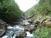
Canyon
A canyon or gorge is a deep ravine between cliffs often carved from the landscape by a river. Rivers have a natural tendency to reach a baseline elevation, which is the same elevation as the body of water it will eventually drain into. This forms a canyon. Most canyons were formed by a process of...
of considerable beauty in Snowdonia
Snowdonia
Snowdonia is a region in north Wales and a national park of in area. It was the first to be designated of the three National Parks in Wales, in 1951.-Name and extent:...
, Gwynedd
Gwynedd
Gwynedd is a county in north-west Wales, named after the old Kingdom of Gwynedd. Although the second biggest in terms of geographical area, it is also one of the most sparsely populated...
, north
North Wales
North Wales is the northernmost unofficial region of Wales. It is bordered to the south by the counties of Ceredigion and Powys in Mid Wales and to the east by the counties of Shropshire in the West Midlands and Cheshire in North West England...
Wales
Wales
Wales is a country that is part of the United Kingdom and the island of Great Britain, bordered by England to its east and the Atlantic Ocean and Irish Sea to its west. It has a population of three million, and a total area of 20,779 km²...
. The A498 road/A4085 road
A4085 road
The A4085 is a 20-mile road between Caernarfon and Penrhyndeudraeth in North Wales that runs through the scenic Aberglaslyn Pass. There are several locations where the road is of substandard width....
follows a relatively level route along the Afon Glaslyn through the pass from Beddgelert
Beddgelert
Beddgelert, or in older English spelling often Bedgellert, is a village and community in the Snowdonia area of Gwynedd, Wales. It is reputed to be named after the legendary hound Gelert. Population 617.- History:...
to Prenteg and then continues at the edge of the Traeth Mawr
Traeth Mawr
The Traeth Mawr is a polder near Porthmadog in Gwynedd in Wales. It was formerly the tidal estuary of the Afon Glaslyn, and many travellers sank in its quicksands trying to cross it. Much of it is between high mountains...
via Tremadog
Tremadog
Tremadog is a village on the outskirts of Porthmadog, in Gwynedd, north west Wales. It was a planned settlement, founded by William Madocks, who bought the land in 1798...
to Porthmadog
Porthmadog
Porthmadog , known locally as "Port", and historically rendered into English as Portmadoc, is a small coastal town and community in the Eifionydd area of Gwynedd, in Wales. Prior to the Local Government Act 1972 it was in the administrative county of Caernarfonshire. The town lies east of...
.
The pass
As recently as the early 19th century, the river Glaslyn was navigable for small boats at high tide as far as Pont Aberglaslyn, which is just one mile south of Beddgelert, where a sixth century monastery was succeeded in the twelfth by an Augustinian priory. In the Middle AgesMiddle Ages
The Middle Ages is a periodization of European history from the 5th century to the 15th century. The Middle Ages follows the fall of the Western Roman Empire in 476 and precedes the Early Modern Era. It is the middle period of a three-period division of Western history: Classic, Medieval and Modern...
Beddgelert was seen as a safe resting place before travelling further. The route from the coast via Beddgelert and overland to Caernarfon
Caernarfon
Caernarfon is a Royal town, community and port in Gwynedd, Wales, with a population of 9,611. It lies along the A487 road, on the east banks of the Menai Straits, opposite the Isle of Anglesey. The city of Bangor is to the northeast, while Snowdonia fringes Caernarfon to the east and southeast...
or Bangor
Bangor, Wales
Bangor is a city in Gwynedd, north west Wales, and one of the smallest cities in Britain. It is a university city with a population of 13,725 at the 2001 census, not including around 10,000 students at Bangor University. Including nearby Menai Bridge on Anglesey, which does not however form part of...
via Llyn Cwellyn
Llyn Cwellyn
Llyn Cwellyn is a reservoir in North Wales which supplies drinking water to parts of Gwynedd and Anglesey. It lies on the Afon Gwyrfai in Nant y Betws between the Snowdon Massif and Mynydd Mawr in the northern part of Snowdonia National Park. It has an area of , and is over deep...
was often considered preferable to the long voyage round the Llŷn Peninsula
Llŷn Peninsula
The Llŷn Peninsula extends into the Irish Sea from north west Wales, south west of the Isle of Anglesey. It is part of the modern county and historic region of Gwynedd. The name is thought to be of Irish origin, and to have the same root Laigin in Irish as the word Leinster...
.
Pont Aberglaslyn is in the parish of Nantmor
Nantmor
Nantmor is a hamlet which lies about 1½ miles to the south of the village of Beddgelert in Gwynedd, North Wales.The current spelling of the name Nantmor is more modern most old documents from the 16th to the 18th century record the name as Nanmor, although the Ordnance Survey map of 1558 records...
. From here to the sea, landowners have benefited significantly from the land reclamation made possible by the construction at Porthmadog in 1812 of the great embankment across the Traeth Mawr
Traeth Mawr
The Traeth Mawr is a polder near Porthmadog in Gwynedd in Wales. It was formerly the tidal estuary of the Afon Glaslyn, and many travellers sank in its quicksands trying to cross it. Much of it is between high mountains...
estuary, known as The Cob.
Pont Aberglaslyn has a bridge with a connection to the Devil. It is very similar to other Devil and bridge related stories found throughout the British Isles. The Devil built the bridge on the understanding that he would receive the soul of the first living creature to cross over it. When the bridge was finished he went to the local inn (Y Delyn Aur) to inform the magician Robin Ddu that it was ready. Robin went to inspect the new bridge with a dog he lured from the pub with a fresh baked loaf of bread. Upon seeing the bridge Robin asked the Devil whether it was sturdy and how much weight it could carry as he thought it might not even take the weight of the loaf he was carrying. The Devil was shocked and demanded that the magician throw his loaf onto the bridge to prove that it was indeed strong enough. So Robin threw the loaf onto the bread and the dog chased it across the bridge, thus cheating the Devil of a human soul. Robin Ddu then returned to the pub to finish his drinking.
In another version of this tale it is a local hotelier who asks Robin to aid him in constructing a bridge and as payment Robin was to take the soul of the first living person that crossed it.
Robin Ddu or Black Robin the Magician, or more correctly Robin Ddu ap Siencyn Bledrydd of Anglesey, lived circa 1450. He was a poet and sometimes a known as a prophetic poet, and about ninety of his pieces are still preserved on manuscripts. It would appear that Robin also pretended to be a sorcerer or wizard and he appears in many Welsh tales.
The railway
In the later 19th century, with the coming of the Cambrian RailwaysCambrian Railways
Cambrian Railways owned of track over a large area of mid-Wales. The system was an amalgamation of a number of railways that were incorporated in 1864, 1865 and 1904...
, numerous schemes were proposed for the construction of a railway to Beddgelert. Some were started and there are several examples of abandoned railway works in the pass. One scheme eventually succeeded and the Welsh Highland Railway
Welsh Highland Railway
The Welsh Highland Railway is a long restored narrow gauge heritage railway in North Wales, operating from Caernarfon to Porthmadog, and passing through a number of popular tourist destinations including Beddgelert and the Aberglaslyn Pass. At Porthmadog it connects with the Ffestiniog Railway...
was opened in 1922 from Dinas
Dinas, Gwynedd
Dinas is a large hamlet near Bontnewydd, Caernarfon, in Gwynedd, north-west Wales.It is in the ancient parish and modern community of Llanwnda and is served by the parish church of St...
near Caernarfon to Porthmadog. The railway was closed in 1937 and the rails requisitioned and removed for War Department use in 1941. The trackbed remained in the ownership of the receiver of the company, and an iron girder bridge was left.
Since then, the railway trackbed and its three tunnels had become a very popular path for walking and hiking. The longest tunnel was first built in 1906, but was not used by rail until 1922. Before the cob was built, the Glaslyn estuary was tidal as far as Pont Aberglaslyn and the fisherman's path through the pass was used as a route to the coast. It gradually fell out of use and through erosion by the river, became impassable.
In 1995 and 1996, controversy ensued, as the Ffestiniog Railway
Ffestiniog Railway
The Ffestiniog Railway is a narrow gauge heritage railway, located in Gwynedd, Wales. It is a major tourist attraction located mainly within the Snowdonia National Park....
was seeking to take ownership of the trackbed to rebuild the Welsh Highland Railway. Walkers and environmentalists claimed that an important footpath would be lost. However, having no real argument (given that the fisherman's path was still alongside the railway owned trackbed), they claimed that owing to danger from falling rocks the pass would be unsafe for trains. In order to meet these objections and fears, civil engineering consultants produced plans for remedial works to overhanging rock, retaining walls and paths and this work was done by local expert contractors.
In the Autumn of 2000, the Welsh Highland Railway closed the trackbed to walkers in order to prepare for the rebuilding of the railway. The railway company, along with the National Trust
National Trust for Places of Historic Interest or Natural Beauty
The National Trust for Places of Historic Interest or Natural Beauty, usually known as the National Trust, is a conservation organisation in England, Wales and Northern Ireland...
, which owns the surrounding land, worked to rebuild the fisherman's path for use again.
In 2003, after some delay, a new footbridge was built across the river at Bryn-y-felin. Prior to this, in 1999, the old railway girder bridge had been removed, although even for some years before that its use as a footbridge had been banned. In March 2006 a replacement girder bridge was installed, this largely identical to the original bridge, which had laid unmaintained since 1936, and was consequently weak through corrosion – the original bridge (of a modular design intended for use in India) had never been painted and never had holes drilled for rain-water to drain away, despite both of these measures being suggested by the railway inspector in the 1920s, hence the advanced state of decay on this and two other identical bridges on the WHR by their time of their removal.
The public continued to unofficially use the trackbed and tunnels as a footpath until construction work on the railway made such use dangerous. Until that point however, the railway had offered better views for walkers than the Fisherman's Path, plus the thrill of walking through the tunnels which also provided a more direct route to Nantmor car-park than the narrow and slippery Fisherman's Path.
Tracklaying progress on the railway reached the pass with the relaying of track across Bryn-y-felin bridge in August 2007, and by mid-October had already passed beyond the tunnels and the stretch of dramatic rock cuttings and embankments near Nantmor.