
A379 road
Encyclopedia


England
England is a country that is part of the United Kingdom. It shares land borders with Scotland to the north and Wales to the west; the Irish Sea is to the north west, the Celtic Sea to the south west, with the North Sea to the east and the English Channel to the south separating it from continental...
county of Devon
Devon
Devon is a large county in southwestern England. The county is sometimes referred to as Devonshire, although the term is rarely used inside the county itself as the county has never been officially "shired", it often indicates a traditional or historical context.The county shares borders with...
. It links points on the edges of that county's two principal cities, Exeter
Exeter
Exeter is a historic city in Devon, England. It lies within the ceremonial county of Devon, of which it is the county town as well as the home of Devon County Council. Currently the administrative area has the status of a non-metropolitan district, and is therefore under the administration of the...
and Plymouth
Plymouth
Plymouth is a city and unitary authority area on the coast of Devon, England, about south-west of London. It is built between the mouths of the rivers Plym to the east and Tamar to the west, where they join Plymouth Sound...
, by an indirect and largely coastal route.
The A38
A38 road
The A38, part of which is also known as the Devon Expressway, is a major A-class trunk road in England.The road runs from Bodmin in Cornwall to Mansfield in Nottinghamshire. It is long, making it one of the longest A-roads in England. It was formerly known as the Leeds — Exeter Trunk Road,...
provides a faster and more direct inland route between Exeter and Plymouth, whilst the A380
A380 road
The A380 is a road in South West England, connecting the Torbay area to the A38, and hence to the rest of Great Britain's main road network.-Route:...
provides a similarly faster route between Exeter and the Torbay
Torbay
Torbay is an east-facing bay and natural harbour, at the western most end of Lyme Bay in the south-west of England, situated roughly midway between the cities of Exeter and Plymouth. Part of the ceremonial county of Devon, Torbay was made a unitary authority on 1 April 1998...
area. However the A379 serves a large number of smaller coastal communities and ports along the coast. The indented nature of the South Devon coast means that the road is usually out of sight of the sea, but the many rivers and estuaries are crossed by bridges and, in one case, a cable ferry
Cable ferry
A cable ferry is guided and in many cases propelled across a river or other larger body of water by cables connected to both shores. They are also called chain ferries, floating bridges, or punts....
.
Route
At its northeastern end, the A379 has two branches and two starting points. One branch starts with a junction with the M5 motorwayM5 motorway
The M5 is a motorway in England. It runs from a junction with the M6 at West Bromwich near Birmingham to Exeter in Devon. Heading south-west, the M5 runs east of West Bromwich and west of Birmingham through Sandwell Valley...
at Clyst St Mary
Clyst St Mary
Clyst St Mary is a small village and civil parish east of Exeter on the main roads to Exmouth and Sidmouth in East Devon. The name comes from the Celtic word clyst meaning 'clear stream'.-Description:...
(J30), whilst the other branch starts with a junction with the A38
A38 road
The A38, part of which is also known as the Devon Expressway, is a major A-class trunk road in England.The road runs from Bodmin in Cornwall to Mansfield in Nottinghamshire. It is long, making it one of the longest A-roads in England. It was formerly known as the Leeds — Exeter Trunk Road,...
at Kennford
Kennford
Kennford is a village situated in Devon, England, several miles to the south of Exeter, in one of the country's main tourist areas.The village became prominent in the 1970s as the location of a new service station on the A38 Devon Expressway between Exeter and Plymouth, near the southern terminus...
. Both these branches were historically part of the A38, and the first crosses the Countess Wear bridges over the River Exe
River Exe
The River Exe in England rises near the village of Simonsbath, on Exmoor in Somerset, near the Bristol Channel coast, but flows more or less directly due south, so that most of its length lies in Devon. It reaches the sea at a substantial ria, the Exe Estuary, on the south coast of Devon...
and the Exeter Canal
Exeter Canal
The Exeter Ship Canal, sometimes just called the Exeter Canal, downstream of Exeter, Devon, England was built in the 1560s which means it pre-dates the "canal mania" period and is one of the oldest artificial waterways in the UK.-History:...
, once infamous for the delays caused on what was then the principal route to the holiday resorts of Devon and Cornwall
Cornwall
Cornwall is a unitary authority and ceremonial county of England, within the United Kingdom. It is bordered to the north and west by the Celtic Sea, to the south by the English Channel, and to the east by the county of Devon, over the River Tamar. Cornwall has a population of , and covers an area of...
.
From the junction of the two branches, some 3 miles (4.8 km) south of Exeter city centre, the A379 heads south parallel to the estuary of the River Exe
River Exe
The River Exe in England rises near the village of Simonsbath, on Exmoor in Somerset, near the Bristol Channel coast, but flows more or less directly due south, so that most of its length lies in Devon. It reaches the sea at a substantial ria, the Exe Estuary, on the south coast of Devon...
. At Starcross
Starcross
Starcross is a riverside village with a population of 1,780, situated on the west bank of the estuary of the River Exe in Teignbridge in the English county of Devon...
the road runs close alongside both the Exeter to Plymouth railway line
Exeter to Plymouth Line
The Exeter to Plymouth line is a central part of the trunk railway line between London Paddington and Penzance railway stations in the southern United Kingdom. It is a major branch of the Great Western Main Line and runs from Exeter, to Plymouth, from where it continues as the Cornish Main Line...
and the estuary, and the Exmouth to Starcross passenger ferry
Exmouth to Starcross Ferry
The Exmouth to Starcross Ferry is a passenger ferry which crosses the mouth of the River Exe in the English county of Devon. It links the town of Exmouth on the eastern side of the Exe estuary to the village of Starcross on the western side. The ferry is operated by Exe to Sea Cruises.The ferry...
provides a connection to Exmouth
Exmouth
Exmouth is a town in Devon. It may also refer to:Places*Exmouth Peninsula in Southern Chile*Exmouth, Western AustraliaPeople*Edward Pellew, 1st Viscount Exmouth , a British naval officerShips...
on the other side of the estuary. Beyond Starcross, the road continues through the coastal resorts of Dawlish
Dawlish
Dawlish is a town and civil parish in Teignbridge on the south coast of Devon in England, from the county town of Exeter. It has a population of 12,819...
and Teignmouth
Teignmouth
Teignmouth is a town and civil parish in Teignbridge in the English county of Devon, situated on the north bank of the estuary mouth of the River Teign about 14 miles south of Exeter. It has a population of 14,413. In 1690, it was the last place in England to be invaded by a foreign power...
.
Leaving Teignmouth, the A379 crosses the estuary of the River Teign
River Teign
The River Teign is a river in the county of Devon, England.Like many Devon rivers, the Teign rises on Dartmoor, near Cranmere Pool. Its course on the moor is crossed by a clapper bridge near Teigncombe, just below the prehistoric Kestor Settlement. It leaves the moor at its eastern side, flowing...
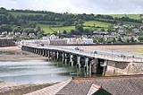
on the historic Shaldon Bridge. The road then continues into the large resort of Torquay
Torquay
Torquay is a town in the unitary authority area of Torbay and ceremonial county of Devon, England. It lies south of Exeter along the A380 on the north of Torbay, north-east of Plymouth and adjoins the neighbouring town of Paignton on the west of the bay. Torquay’s population of 63,998 during the...
, where it meets the A3022 road. The two road designations share the same physical road through the Torbay
Torbay
Torbay is an east-facing bay and natural harbour, at the western most end of Lyme Bay in the south-west of England, situated roughly midway between the cities of Exeter and Plymouth. Part of the ceremonial county of Devon, Torbay was made a unitary authority on 1 April 1998...
area, although only the A3022 is signed. At Paignton
Paignton
Paignton is a coastal town in Devon in England. Together with Torquay and Brixham it forms the unitary authority of Torbay which was created in 1998. The Torbay area is a holiday destination known as the English Riviera. Paignton's population in the United Kingdom Census of 2001 was 48,251. It has...
the two roads diverge, and the A379 follows a route through Goodrington
Goodrington
Goodrington is a coastal village in Devon, England. It is situated in Torbay and lies between Torquay and Brixham, less than south of Paignton....
before briefly rejoining the A3022 at Churston
Churston
Churston Ferrers is a historic civil parish within Torbay, in Devon, England. It contains the two villages of Churston, a coastal village, and the now larger Galmpton. It is situated in between Paignton and Brixham....
.
From Churston, the A379 bypasses Kingswear
Kingswear
Kingswear is a village and civil parish in the South Hams area of the English county of Devon. The village is located on the east bank of the tidal River Dart, close to the river's mouth and opposite the small town of Dartmouth...
before crossing the Paignton and Dartmouth Steam Railway
Paignton and Dartmouth Steam Railway
The Paignton & Dartmouth Steam Railway is a heritage railway on the former Kingswear branch line between Paignton and Kingswear in Torbay, Devon, England....
on a level crossing
Level crossing
A level crossing occurs where a railway line is intersected by a road or path onone level, without recourse to a bridge or tunnel. It is a type of at-grade intersection. The term also applies when a light rail line with separate right-of-way or reserved track crosses a road in the same fashion...
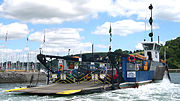
and reaching the Dartmouth Higher Ferry
Dartmouth Higher Ferry
The Dartmouth Higher Ferry, also known as the Dartmouth–Kingswear Floating Bridge, is a vehicular cable ferry which crosses the River Dart in the English county of Devon...
on the banks of the River Dart
River Dart
The River Dart is a river in Devon, England which rises high on Dartmoor, and releases to the sea at Dartmouth. Its valley and surrounding area is a place of great natural beauty.-Watercourse:...
. This tolled vehicular ferry carries the road across the river and into the picturesque harbour town of Dartmouth
Dartmouth, Devon
Dartmouth is a town and civil parish in the English county of Devon. It is a tourist destination set on the banks of the estuary of the River Dart, which is a long narrow tidal ria that runs inland as far as Totnes...
. From here the A379 continues via Stoke Fleming
Stoke Fleming
Stoke Fleming is a village and civil parish in the South Hams district of Devon, England. It lies on the A379 road about one and a half miles south of the town of Dartmouth, at the north end of Start Bay and within the South Devon Area of Outstanding Natural Beauty...
and then along the coast at Slapton
Slapton, Devon
Slapton is a village in Devon, England. It is located near the A379 road between Kingsbridge and Dartmouth, and lies within the South Devon Area of Outstanding Natural Beauty . In 2001 the population of the civil parish of Slapton was 473...
. Here the road runs behind the beach, between the sea and the Slapton Ley
Slapton Ley
Slapton Ley is a lagoon on the south coast of Devon, England, separated from Start Bay by a shingle beach, known as Slapton Sands.It is the largest natural freshwater lake in South West England....
lagoon. Turning inland, it then proceeds to the town of Kingsbridge
Kingsbridge
Kingsbridge is a market town and popular tourist hub in the South Hams district of Devon, England, with a population of about 5,800. It is situated at the northern end of the Kingsbridge Estuary, which is a textbook example of a ria and extends to the sea six miles south of the town.-History:The...
at the head of the Kingsbridge Estuary
Kingsbridge Estuary
The Kingsbridge Estuary is located in the South Hams area of Devon, England, running from Kingsbridge in the north to its mouth at the English Channel near Salcombe...
.
From Kingsbridge, the A379 passes through the villages of Aveton Gifford
Aveton Gifford
Aveton Gifford is a small rural village in the south of the English county of Devon. It lies at the head of the estuary of the River Avon or Aune, at the point where it is crossed by the A379 road. It receives its name from this river and also from the family of Giffard who held the manor...
, where it crosses the River Avon
River Avon, Devon
The River Avon, also known as the River Aune, is a river in the county of Devon in the south of England. It rises in the southern half of Dartmoor National Park in an area of bog to the west of Ryder's Hill. Close to where the river leaves Dartmoor a dam was built in 1957 to form the Avon reservoir...
, and Modbury
Modbury
Modbury is a town and parish in the South Hams region of the English county of Devon. It is situated on the A379 road, which links it to Plymouth and Kingsbridge...
, shortly after which it crosses the River Erme
River Erme
The Erme is a river in south Devon, England. From its source on Dartmoor it flows in a generally southerly direction past some of the best-preserved archaeological remains on the moor. It leaves the moor at the town of Ivybridge and continues southward, passing the settlements of Ermington, Modbury...
. The villages of Yealmpton
Yealmpton
Yealmpton is a village in the English county of Devon. It is located on the A379 Plymouth to Kingsbridge road and is about from Plymouth. It derives its name from the River Yealm that flows through the village. Yealmpton is home to a 400 year-old stone cottage, where it is said, a version of the...
, on the River Yealm
River Yealm
Yealm is a river in Dartmoor in Devon in south-west England. It rises 1,411 feet above sea level on the Stall Moor mires of south Dartmoor and makes a 12 mile journey to the sea, passing through Cornwood, Lee Mill and Yealmpton, before reaching the estuary mouth just below Newton Ferrers and Noss...
, and Brixton
Brixton, Devon
Brixton is a village near Plymouth in England. It is located on the A379 Plymouth to Kingsbridge road and is about from Plymouth. Its population is 1207.It has views of the River Yealm. The church is 15th century, with a tower arch 200 years older.**...
follow. The road then runs into the suburbs of Plymouth, bypassing Plymstock
Plymstock
Plymstock is a civil parish and commuter suburb of Plymouth in the English county of Devon.The earliest surviving documentary reference to the place is as Plemestocha in the Domesday Book and its name is derived from Old English meaning either "outlying farm with a plum-tree" or, if it is short for...
before crossing the estuary of the River Plym
River Plym
The River Plym is a river in Devon, England. Its source is some 450m above sea level on Dartmoor, in an upland marshy area called Plym Head. From the upper reaches which contain antiquities and mining remains the river flows roughly southwest and enters the sea near to the city of Plymouth, where...
on the Laira Bridge
Laira Bridge
Laira Bridge is a disused railway bridge that crosses the River Plym.The bridge opened in 1887 to carry the London and South Western Railway branch to Turnchapel over the River Plym in Devon. Later the Great Western Railway also had running powers over the bridge providing access to their Yealmpton...
. The A379 ends on the west side of the Plym, joining the A374
A374 road
The A374 is a main road in the United Kingdom, one of six A-roads making the border crossing between Devon and Cornwall. It is the most southerly of the A37x group of roads, starting and ending its journey with the A38 trunk road, from the outskirts of Plymouth in Devon to the Trerulefoot...
just over 1 miles (1.6 km) east of Plymouth city centre.
Trafficability
Apart from short stretches of dual carriagewayDual carriageway
A dual carriageway is a class of highway with two carriageways for traffic travelling in opposite directions separated by a central reservation...
at either end and in Torquay, the A379 is a single carriageway
Single carriageway
A single carriageway is a road with 1, 2 or more lanes arranged within a single carriageway with no central reservation to separate opposing flows of traffic. Two-lane road or two-lane highway are single carriageway with one lane for each direction...
road, and is often narrow and twisting. Like all roads in England of any significance, it is sealed throughout.
The A379 crosses the River Dart
River Dart
The River Dart is a river in Devon, England which rises high on Dartmoor, and releases to the sea at Dartmouth. Its valley and surrounding area is a place of great natural beauty.-Watercourse:...
using the Higher Ferry
Dartmouth Higher Ferry
The Dartmouth Higher Ferry, also known as the Dartmouth–Kingswear Floating Bridge, is a vehicular cable ferry which crosses the River Dart in the English county of Devon...
, a car ferry that until 2009 had a capacity of just 18 cars, which caused congestion at busy times. A new ferryboat with a capacity of 32 cars came into service in June 2009. The alternative Lower Ferry
Dartmouth Lower Ferry
The Dartmouth Lower Ferry is a vehicular and passenger ferry which crosses the River Dart in the English county of Devon. It is one of three ferries that cross the tidal river from Dartmouth to Kingswear, the others being the Higher Ferry and the Passenger Ferry...
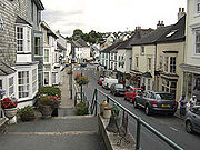
can also be used, although this involves negotiating the narrow streets of Kingswear village.