
70th parallel north
Encyclopedia
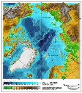
The 70th parallel north is a circle of latitude
that is 70 degrees
north
of the Earth's
equatorial plane
, in the Arctic
. It crosses the Atlantic Ocean
, Europe
, Asia
and North America
, and passes through some of the southern seas of the Arctic Ocean
.
On 21 June the sun is at 43.83 degrees in the sky and doesn't set. However, there is no sunshine on 21 December.
Starting at the Prime Meridian
and heading eastwards, the parallel 70° north passes through:
Circle of latitude
A circle of latitude, on the Earth, is an imaginary east-west circle connecting all locations that share a given latitude...
that is 70 degrees
Degree (angle)
A degree , usually denoted by ° , is a measurement of plane angle, representing 1⁄360 of a full rotation; one degree is equivalent to π/180 radians...
north
True north
True north is the direction along the earth's surface towards the geographic North Pole.True geodetic north usually differs from magnetic north , and from grid north...
of the Earth's
Earth
Earth is the third planet from the Sun, and the densest and fifth-largest of the eight planets in the Solar System. It is also the largest of the Solar System's four terrestrial planets...
equatorial plane
Equator
An equator is the intersection of a sphere's surface with the plane perpendicular to the sphere's axis of rotation and containing the sphere's center of mass....
, in the Arctic
Arctic
The Arctic is a region located at the northern-most part of the Earth. The Arctic consists of the Arctic Ocean and parts of Canada, Russia, Greenland, the United States, Norway, Sweden, Finland, and Iceland. The Arctic region consists of a vast, ice-covered ocean, surrounded by treeless permafrost...
. It crosses the Atlantic Ocean
Atlantic Ocean
The Atlantic Ocean is the second-largest of the world's oceanic divisions. With a total area of about , it covers approximately 20% of the Earth's surface and about 26% of its water surface area...
, Europe
Europe
Europe is, by convention, one of the world's seven continents. Comprising the westernmost peninsula of Eurasia, Europe is generally 'divided' from Asia to its east by the watershed divides of the Ural and Caucasus Mountains, the Ural River, the Caspian and Black Seas, and the waterways connecting...
, Asia
Asia
Asia is the world's largest and most populous continent, located primarily in the eastern and northern hemispheres. It covers 8.7% of the Earth's total surface area and with approximately 3.879 billion people, it hosts 60% of the world's current human population...
and North America
North America
North America is a continent wholly within the Northern Hemisphere and almost wholly within the Western Hemisphere. It is also considered a northern subcontinent of the Americas...
, and passes through some of the southern seas of the Arctic Ocean
Arctic Ocean
The Arctic Ocean, located in the Northern Hemisphere and mostly in the Arctic north polar region, is the smallest and shallowest of the world's five major oceanic divisions...
.
On 21 June the sun is at 43.83 degrees in the sky and doesn't set. However, there is no sunshine on 21 December.
Starting at the Prime Meridian
Prime Meridian
The Prime Meridian is the meridian at which the longitude is defined to be 0°.The Prime Meridian and its opposite the 180th meridian , which the International Date Line generally follows, form a great circle that divides the Earth into the Eastern and Western Hemispheres.An international...
and heading eastwards, the parallel 70° north passes through:
| Co-ordinates | Country, territory or sea | Notes |
|---|---|---|
| 70°0′N 0°0′E | Atlantic Ocean Atlantic Ocean The Atlantic Ocean is the second-largest of the world's oceanic divisions. With a total area of about , it covers approximately 20% of the Earth's surface and about 26% of its water surface area... |
Norwegian Sea Norwegian Sea The Norwegian Sea is a marginal sea in the North Atlantic Ocean, northwest of Norway. It is located between the North Sea and the Greenland Sea and adjoins the North Atlantic Ocean to the west and the Barents Sea to the northeast. In the southwest, it is separated from the Atlantic Ocean by a... |
| 70°0′N 18°40′E | ||
| 70°0′N 27°22′E | Passing about 10km south of the northernmost point of Finland, which is located at 70°05.537′N 27°57.335′E in the village of Nuorgam Nuorgam Nuorgam is a village in the Utsjoki municipality in the region of Lapland, Finland. It has approximately 200 inhabitants. It is near the northernmost point of Finland and the northernmost point of the European Union.... |
|
| 70°0′N 28°2′E | ||
| 70°0′N 29°30′E | Barents Sea Barents Sea The Barents Sea is a marginal sea of the Arctic Ocean, located north of Norway and Russia. Known in the Middle Ages as the Murman Sea, the sea takes its current name from the Dutch navigator Willem Barents... |
|
| 70°0′N 58°44′E | Vaygach Island Vaygach Island Vaygach Island is an island in the Arctic Sea between the Pechora Sea and the Kara Sea.Vaygach Island is separated from the Yugorsky Peninsula in the mainland by the Yugorsky Strait and from Novaya Zemlya by the Kara Strait... |
|
| 70°0′N 60°12′E | Kara Sea Kara Sea The Kara Sea is part of the Arctic Ocean north of Siberia. It is separated from the Barents Sea to the west by the Kara Strait and Novaya Zemlya, and the Laptev Sea to the east by the Severnaya Zemlya.... |
|
| 70°0′N 66°56′E | Yamal Peninsula Yamal Peninsula The Yamal Peninsula , located in Yamal-Nenets autonomous district of northwest Siberia, Russia, extends roughly 700 km and is bordered principally by the Kara Sea, Baydaratskaya Bay on the west, and by the Gulf of Ob on the east... |
|
| 70°0′N 72°30′E | Gulf of Ob Gulf of Ob The Gulf of Ob is a gigantic bay of the Arctic Ocean, located in Northern Russia at the head the mouth of the Ob River.... |
|
| 70°0′N 73°45′E | ||
| 70°0′N 159°53′E | East Siberian Sea East Siberian Sea The East Siberian Sea is a marginal sea in the Arctic Ocean. It is located between the Arctic Cape to the north, the coast of Siberia to the south, the New Siberian Islands to the west and Cape Billings, close to Chukotka, and Wrangel Island to the east... |
|
| 70°0′N 168°13′E | Ayon Island Ayon Island Ayon Island is an island in the coast of Chukotka in the East Siberian Sea. The island itself consists mainly of low lying tundra, is populated mainly by Chukchi, who use the tundra as pasture for their reindeer herds.-Geography:... |
|
| 70°0′N 168°31′E | East Siberian Sea East Siberian Sea The East Siberian Sea is a marginal sea in the Arctic Ocean. It is located between the Arctic Cape to the north, the coast of Siberia to the south, the New Siberian Islands to the west and Cape Billings, close to Chukotka, and Wrangel Island to the east... |
|
| 70°0′N 170°35′E | ||
| 70°0′N 171°48′E | East Siberian Sea East Siberian Sea The East Siberian Sea is a marginal sea in the Arctic Ocean. It is located between the Arctic Cape to the north, the coast of Siberia to the south, the New Siberian Islands to the west and Cape Billings, close to Chukotka, and Wrangel Island to the east... |
|
| 70°0′N 177°56′E | Chukchi Sea Chukchi Sea Chukchi Sea is a marginal sea of the Arctic Ocean. It is bounded on the west by the De Long Strait, off Wrangel Island, and in the east by Point Barrow, Alaska, beyond which lies the Beaufort Sea. The Bering Strait forms its southernmost limit and connects it to the Bering Sea and the Pacific... |
|
| 70°0′N 162°27′W | Alaska Alaska Alaska is the largest state in the United States by area. It is situated in the northwest extremity of the North American continent, with Canada to the east, the Arctic Ocean to the north, and the Pacific Ocean to the west and south, with Russia further west across the Bering Strait... |
|
| 70°0′N 142°34′W | Beaufort Sea Beaufort Sea The Beaufort Sea is a marginal sea of the Arctic Ocean, located north of the Northwest Territories, the Yukon, and Alaska, west of Canada's Arctic islands. The sea is named after hydrographer Sir Francis Beaufort... |
|
| 70°0′N 131°2′W | Northwest Territories Northwest Territories The Northwest Territories is a federal territory of Canada.Located in northern Canada, the territory borders Canada's two other territories, Yukon to the west and Nunavut to the east, and three provinces: British Columbia to the southwest, and Alberta and Saskatchewan to the south... - Tuktoyaktuk Peninsula |
|
| 70°0′N 129°30′W | Beaufort Sea Beaufort Sea The Beaufort Sea is a marginal sea of the Arctic Ocean, located north of the Northwest Territories, the Yukon, and Alaska, west of Canada's Arctic islands. The sea is named after hydrographer Sir Francis Beaufort... |
|
| 70°0′N 128°18′W | Northwest Territories Northwest Territories The Northwest Territories is a federal territory of Canada.Located in northern Canada, the territory borders Canada's two other territories, Yukon to the west and Nunavut to the east, and three provinces: British Columbia to the southwest, and Alberta and Saskatchewan to the south... - Cape Bathurst Peninsula |
|
| 70°0′N 126°54′W | Amundsen Gulf Amundsen Gulf Amundsen Gulf is a gulf located in Canadian Northwest Territories, between Banks Island and Victoria Island and the mainland . It is approximately in length and about across where it meets the Beaufort Sea.... |
|
| 70°0′N 125°12′W | Northwest Territories Northwest Territories The Northwest Territories is a federal territory of Canada.Located in northern Canada, the territory borders Canada's two other territories, Yukon to the west and Nunavut to the east, and three provinces: British Columbia to the southwest, and Alberta and Saskatchewan to the south... - Parry Peninsula Parry Peninsula The Parry Peninsula is located on the north coast of Canada's Northwest Territories. It is bounded on the west by Franklin Bay, on the north by Amundsen Gulf, and on the east by Darnley Bay. The nearest settlement is Paulatuk.... |
|
| 70°0′N 124°30′W | Amundsen Gulf Amundsen Gulf Amundsen Gulf is a gulf located in Canadian Northwest Territories, between Banks Island and Victoria Island and the mainland . It is approximately in length and about across where it meets the Beaufort Sea.... |
|
| 70°0′N 117°22′W | On Victoria Island: > - Northwest Territories Northwest Territories The Northwest Territories is a federal territory of Canada.Located in northern Canada, the territory borders Canada's two other territories, Yukon to the west and Nunavut to the east, and three provinces: British Columbia to the southwest, and Alberta and Saskatchewan to the south... > - Northwest Territories Northwest Territories The Northwest Territories is a federal territory of Canada.Located in northern Canada, the territory borders Canada's two other territories, Yukon to the west and Nunavut to the east, and three provinces: British Columbia to the southwest, and Alberta and Saskatchewan to the south... / Nunavut Nunavut Nunavut is the largest and newest federal territory of Canada; it was separated officially from the Northwest Territories on April 1, 1999, via the Nunavut Act and the Nunavut Land Claims Agreement Act, though the actual boundaries had been established in 1993... border > - Northwest Territories Northwest Territories The Northwest Territories is a federal territory of Canada.Located in northern Canada, the territory borders Canada's two other territories, Yukon to the west and Nunavut to the east, and three provinces: British Columbia to the southwest, and Alberta and Saskatchewan to the south... > - Northwest Territories Northwest Territories The Northwest Territories is a federal territory of Canada.Located in northern Canada, the territory borders Canada's two other territories, Yukon to the west and Nunavut to the east, and three provinces: British Columbia to the southwest, and Alberta and Saskatchewan to the south... / Nunavut Nunavut Nunavut is the largest and newest federal territory of Canada; it was separated officially from the Northwest Territories on April 1, 1999, via the Nunavut Act and the Nunavut Land Claims Agreement Act, though the actual boundaries had been established in 1993... border > - Nunavut Nunavut Nunavut is the largest and newest federal territory of Canada; it was separated officially from the Northwest Territories on April 1, 1999, via the Nunavut Act and the Nunavut Land Claims Agreement Act, though the actual boundaries had been established in 1993... |
|
| 70°0′N 100°48′W | Victoria Strait Victoria Strait Victoria Strait is a strait in northern Canada that lies in Nunavut off the mainland in the Arctic Ocean. It is between Victoria Island to the west and King William Island to the east. From the north the strait links the M'Clintock Channel and the Larsen Sound with the Queen Maud Gulf to the south... |
|
| 70°0′N 98°50′W | Larsen Sound Larsen Sound Larsen Sound is an Arctic waterway in the Kitikmeot Region, Nunavut, Canada.It is located south of Prince of Wales Island, west of the Boothia Peninsula, north of King William Island and east of Gateshead Island... |
Passing just north of King William Island King William Island King William Island is an island in the Kitikmeot Region of Nunavut and forms part of the Canadian Arctic Archipelago. In area it is between and making it the 61st largest island in the world and Canada's 15th largest island... , Nunavut Nunavut Nunavut is the largest and newest federal territory of Canada; it was separated officially from the Northwest Territories on April 1, 1999, via the Nunavut Act and the Nunavut Land Claims Agreement Act, though the actual boundaries had been established in 1993... , |
| 70°0′N 97°35′W | James Ross Strait James Ross Strait James Ross Strait, an arm of the Arctic Ocean, is a channel between King William Island and the Boothia Peninsula in the Canadian province of Nunavut. long, and to wide, it connects M'Clintock Channel to the Rae Strait to the south... |
Passing just north of the Clarence Islands Clarence Islands The Clarence Islands are a Canadian Arctic island group in the Nunavut Territory. The islands lie in the James Ross Strait, east of Cape Felix, off the northeast coast of King William Island... , Nunavut Nunavut Nunavut is the largest and newest federal territory of Canada; it was separated officially from the Northwest Territories on April 1, 1999, via the Nunavut Act and the Nunavut Land Claims Agreement Act, though the actual boundaries had been established in 1993... , |
| 70°0′N 96°17′W | Boothia Peninsula Boothia Peninsula Boothia Peninsula is a large peninsula in Nunavut's northern Canadian Arctic, south of Somerset Island. The northern part, Murchison Promontory, is the northernmost point of mainland Canada, and thus North America.... , Nunavut Nunavut Nunavut is the largest and newest federal territory of Canada; it was separated officially from the Northwest Territories on April 1, 1999, via the Nunavut Act and the Nunavut Land Claims Agreement Act, though the actual boundaries had been established in 1993... |
|
| 70°0′N 92°1′W | Gulf of Boothia Gulf of Boothia The Gulf of Boothia is a body of water in Nunavut, Canada, the western side being within Kitikmeot Region while the eastern side is in Qikiqtaaluk Region. It is situated between Baffin Island and the Boothia Peninsula... |
|
| 70°0′N 86°54′W | Nunavut Nunavut Nunavut is the largest and newest federal territory of Canada; it was separated officially from the Northwest Territories on April 1, 1999, via the Nunavut Act and the Nunavut Land Claims Agreement Act, though the actual boundaries had been established in 1993... - Crown Prince Frederik Island Crown Prince Frederik Island Crown Prince Frederik Island is an island in Nunavut, Canada. It is located off the southern coast of western Baffin Island, in the Qikiqtaaluk Region's side of the Gulf of Boothia. It has an area of .- External links :* *... |
|
| 70°0′N 86°27′W | Fury and Hecla Strait Fury and Hecla Strait Fury and Hecla Strait is a narrow channel of water located in the Qikiqtaaluk Region of Nunavut, Canada. Situated between Baffin Island and Melville Peninsula it connects Foxe Basin, to the east, with the Gulf of Boothia, to the west.... |
|
| 70°0′N 84°20′W | Nunavut Nunavut Nunavut is the largest and newest federal territory of Canada; it was separated officially from the Northwest Territories on April 1, 1999, via the Nunavut Act and the Nunavut Land Claims Agreement Act, though the actual boundaries had been established in 1993... - Baffin Island Baffin Island Baffin Island in the Canadian territory of Nunavut is the largest island in the Canadian Arctic Archipelago, the largest island in Canada and the fifth largest island in the world. Its area is and its population is about 11,000... |
|
| 70°0′N 81°9′W | Murray Maxwell Bay Murray Maxwell Bay Murray Maxwell Bay is an uninhabited waterway in Qikiqtaaluk Region, Nunavut, Canada. It is located in the Foxe Basin, north of Baffin Island's Siorarsuk Peninsula... |
|
| 70°0′N 80°19′W | Nunavut Nunavut Nunavut is the largest and newest federal territory of Canada; it was separated officially from the Northwest Territories on April 1, 1999, via the Nunavut Act and the Nunavut Land Claims Agreement Act, though the actual boundaries had been established in 1993... - Baffin Island Baffin Island Baffin Island in the Canadian territory of Nunavut is the largest island in the Canadian Arctic Archipelago, the largest island in Canada and the fifth largest island in the world. Its area is and its population is about 11,000... |
|
| 70°0′N 78°39′W | Steensby Inlet Steensby Inlet Steensby Inlet is a waterway in Nunavut's Qikiqtaaluk Region. It extends northerly from Foxe Basin into central Baffin Island. There are several un-named islands within the inlet, and Koch Island lies outside of it... |
|
| 70°0′N 77°41′W | Nunavut Nunavut Nunavut is the largest and newest federal territory of Canada; it was separated officially from the Northwest Territories on April 1, 1999, via the Nunavut Act and the Nunavut Land Claims Agreement Act, though the actual boundaries had been established in 1993... - Baffin Island Baffin Island Baffin Island in the Canadian territory of Nunavut is the largest island in the Canadian Arctic Archipelago, the largest island in Canada and the fifth largest island in the world. Its area is and its population is about 11,000... |
|
| 70°0′N 67°20′W | Baffin Bay Baffin Bay Baffin Bay , located between Baffin Island and the southwest coast of Greenland, is a marginal sea of the North Atlantic Ocean. It is connected to the Atlantic via Davis Strait and the Labrador Sea... |
Northern limit of the Davis Strait Davis Strait Davis Strait is a northern arm of the Labrador Sea. It lies between mid-western Greenland and Nunavut, Canada's Baffin Island. The strait was named for the English explorer John Davis , who explored the area while seeking a Northwest Passage.... |
| 70°0′N 54°38′W | Disko Island Disko Island Disko Island is a large island in Baffin Bay, off the west coast of Greenland. It has an area of , making it the second largest island of Greenland and one of the 100 largest islands in the world... and mainland |
|
| 70°0′N 22°18′W | Arctic Ocean Arctic Ocean The Arctic Ocean, located in the Northern Hemisphere and mostly in the Arctic north polar region, is the smallest and shallowest of the world's five major oceanic divisions... |
Greenland Sea Greenland Sea The Greenland Sea is a body of water that borders Greenland to the west, the Svalbard archipelago to the east, Fram Strait and the Arctic Ocean to the north, and the Norwegian Sea and Iceland to the south. The Greenland Sea is often defined as part of the Arctic Ocean, sometimes as part of the... > Norwegian Sea Norwegian Sea The Norwegian Sea is a marginal sea in the North Atlantic Ocean, northwest of Norway. It is located between the North Sea and the Greenland Sea and adjoins the North Atlantic Ocean to the west and the Barents Sea to the northeast. In the southwest, it is separated from the Atlantic Ocean by a... |
See also
- 69th parallel north69th parallel northThe 69th parallel north is a circle of latitude that is 69 degrees north of the Earth's equatorial plane, in the Arctic. It crosses the Atlantic Ocean, Europe, Asia and North America, and passes through some of the southern seas of the Arctic Ocean....
- 71st parallel north71st parallel northThe 71st parallel north is a circle of latitude that is 71 degrees north of the Earth's equatorial plane, in the Arctic. It crosses the Atlantic Ocean, Europe, Asia and North America, and passes through some of the southern seas of the Arctic Ocean....