The
Barents Sea is a
marginal seaThe term marginal sea has differing meanings. In one sense the term is equivalent to territorial waters. In another sense the term indicates a partially enclosed sea adjacent to or widely open to the open ocean, but bounded by submarine ridges...
of the
Arctic OceanThe Arctic Ocean, located in the Northern Hemisphere and mostly in the Arctic north polar region, is the smallest and shallowest of the world's five major oceanic divisions...
, located north of
NorwayNorway , officially the Kingdom of Norway, is a Nordic unitary constitutional monarchy whose territory comprises the western portion of the Scandinavian Peninsula, Jan Mayen, and the Arctic archipelago of Svalbard and Bouvet Island. Norway has a total area of and a population of about 4.9 million...
and
RussiaRussia or , officially known as both Russia and the Russian Federation , is a country in northern Eurasia. It is a federal semi-presidential republic, comprising 83 federal subjects...
. Known in the
Middle AgeMiddle age is the period of age beyond young adulthood but before the onset of old age. Various attempts have been made to define this age, which is around the third quarter of the average life span of human beings....
s as the
Murman Sea, the sea takes its current name from the
DutchThe Netherlands is a constituent country of the Kingdom of the Netherlands, located mainly in North-West Europe and with several islands in the Caribbean. Mainland Netherlands borders the North Sea to the north and west, Belgium to the south, and Germany to the east, and shares maritime borders...
navigator
Willem BarentsWillem Barentsz was a Dutch navigator, cartographer, explorer, and a leader of early expeditions to the far north....
. It is a rather deep
shelfThe continental shelf is the extended perimeter of each continent and associated coastal plain. Much of the shelf was exposed during glacial periods, but is now submerged under relatively shallow seas and gulfs, and was similarly submerged during other interglacial periods. The continental margin,...
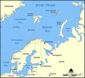
sea (average depth 760 feet (231.6 m) and maximum depth 1480 feet (451.1 m)), bordered by the shelf edge towards the
Norwegian SeaThe Norwegian Sea is a marginal sea in the North Atlantic Ocean, northwest of Norway. It is located between the North Sea and the Greenland Sea and adjoins the North Atlantic Ocean to the west and the Barents Sea to the northeast. In the southwest, it is separated from the Atlantic Ocean by a...
in the west, the islands of
SvalbardSvalbard is an archipelago in the Arctic, constituting the northernmost part of Norway. It is located north of mainland Europe, midway between mainland Norway and the North Pole. The group of islands range from 74° to 81° north latitude , and from 10° to 35° east longitude. Spitsbergen is the...
(Norway) in the northwest, and the islands of
Franz Josef LandFranz Josef Land, Franz Joseph Land, or Francis Joseph's Land is an archipelago located in the far north of Russia. It is found in the Arctic Ocean north of Novaya Zemlya and east of Svalbard, and is administered by Arkhangelsk Oblast. Franz Josef Land consists of 191 ice-covered islands with a...
and
Novaya ZemlyaNovaya Zemlya , also known in Dutch as Nova Zembla and in Norwegian as , is an archipelago in the Arctic Ocean in the north of Russia and the extreme northeast of Europe, the easternmost point of Europe lying at Cape Flissingsky on the northern island...
(
Arkhangelsk OblastArkhangelsk Oblast is a federal subject of Russia . It includes the Arctic archipelagos of Franz Josef Land and Novaya Zemlya, as well as the Solovetsky Islands in the White Sea....
) in the northeast and east. Novaya Zemlya separates the
Kara SeaThe Kara Sea is part of the Arctic Ocean north of Siberia. It is separated from the Barents Sea to the west by the Kara Strait and Novaya Zemlya, and the Laptev Sea to the east by the Severnaya Zemlya....
from the Barents Sea. Significant
fossil fuelFossil fuels are fuels formed by natural processes such as anaerobic decomposition of buried dead organisms. The age of the organisms and their resulting fossil fuels is typically millions of years, and sometimes exceeds 650 million years...
energy resources exist in the Barents Sea region.
Geography
The southern half of the Barents Sea, including the ports of
MurmanskMurmansk is a city and the administrative center of Murmansk Oblast, Russia. It serves as a seaport and is located in the extreme northwest part of Russia, on the Kola Bay, from the Barents Sea on the northern shore of the Kola Peninsula, not far from Russia's borders with Norway and Finland...
(Russia) and
Vardøis a town and a municipality in Finnmark county in the extreme northeast part of Norway.Vardø was established as a municipality on 1 January 1838 . The law required that all cities should be separated from their rural districts, but because of a low population and very few voters, this was...
(Norway) remain
iceIce is water frozen into the solid state. Usually ice is the phase known as ice Ih, which is the most abundant of the varying solid phases on the Earth's surface. It can appear transparent or opaque bluish-white color, depending on the presence of impurities or air inclusions...
-free year round due to the warm
North Atlantic driftNorth Atlantic Drift is:* An ocean current that continues from the North Atlantic Current* An album by Ocean Colour Scene: North Atlantic Drift this doesn't make any goddamn sense....
. In September, the entire Barents Sea is more or less completely ice-free. Until the
Winter WarThe Winter War was a military conflict between the Soviet Union and Finland. It began with a Soviet offensive on 30 November 1939 – three months after the start of World War II and the Soviet invasion of Poland – and ended on 13 March 1940 with the Moscow Peace Treaty...
(1939–40),
FinlandFinland , officially the Republic of Finland, is a Nordic country situated in the Fennoscandian region of Northern Europe. It is bordered by Sweden in the west, Norway in the north and Russia in the east, while Estonia lies to its south across the Gulf of Finland.Around 5.4 million people reside...
's territory also reached to the Barents Sea, with the harbor at
PetsamoPechengsky District is an administrative and municipal district , one of the five in Murmansk Oblast, Russia. It is located to the northwest of the Kola Peninsula on the coast of the Barents Sea and borders with Finland in the south and southwest and with Norway in the west, northwest, and north...
being Finland's only ice-free winter harbor.
There are three main types of
water massAn oceanographic water mass is an identifiable body of water with a common formation history which has physical properties distinct from surrounding water...
es in the Barents Sea: Warm, salty Atlantic water (temperature >3°C,
salinitySalinity is the saltiness or dissolved salt content of a body of water. It is a general term used to describe the levels of different salts such as sodium chloride, magnesium and calcium sulfates, and bicarbonates...
>35) from the
North Atlantic driftNorth Atlantic Drift is:* An ocean current that continues from the North Atlantic Current* An album by Ocean Colour Scene: North Atlantic Drift this doesn't make any goddamn sense....
, cold Arctic water (temperature <0°C, salinity <35) from the north, and warm, but not very salty coastal water (temperature >3°C, salinity <34.7). Between the Atlantic and Polar waters, a front called the Polar Front is formed. In the western parts of the sea (close to Bear Island), this front is determined by the bottom topography and is therefore relatively sharp and stable from year to year, while in the east (towards
Novaya ZemlyaNovaya Zemlya , also known in Dutch as Nova Zembla and in Norwegian as , is an archipelago in the Arctic Ocean in the north of Russia and the extreme northeast of Europe, the easternmost point of Europe lying at Cape Flissingsky on the northern island...
), it can be quite diffuse and its position can vary a lot between years.
The lands of Novaya Zemlya attained most their early Holocene coastal deglaciation approximately 10,000 years before present.
Extent
The
International Hydrographic OrganizationThe International Hydrographic Organization is the inter-governmental organisation representing the hydrographic community. It enjoys observer status at the UN and is the recognised competent authority on hydrographic surveying and nautical charting...
defines the limits of the "Barentsz Sea" as follows:
On the West. The Northeastern limit of the Norwegian SeaThe Norwegian Sea is a marginal sea in the North Atlantic Ocean, northwest of Norway. It is located between the North Sea and the Greenland Sea and adjoins the North Atlantic Ocean to the west and the Barents Sea to the northeast. In the southwest, it is separated from the Atlantic Ocean by a...
[A line joining the Southernmost point of West SpitzbergenSpitsbergen is the largest and only permanently populated island of the Svalbard archipelago in Norway. Constituting the western-most bulk of the archipelago, it borders the Arctic Ocean, the Norwegian Sea and the Greenland Sea...
to North Cape of Bear Island, through this island to Cape Bull and thence on to North CapeNorth Cape is a cape on the island of Magerøya in Northern Norway, in the municipality of Nordkapp. Its 307 m high, steep cliff is often referred to as the northernmost point of Europe, located at , 2102.3 km from the North Pole. However, the neighbouring point Knivskjellodden is actually...
in NorwayNorway , officially the Kingdom of Norway, is a Nordic unitary constitutional monarchy whose territory comprises the western portion of the Scandinavian Peninsula, Jan Mayen, and the Arctic archipelago of Svalbard and Bouvet Island. Norway has a total area of and a population of about 4.9 million...
(27°45'E)].
On the Northwest. The Eastern shore of West Spitzbergen , Henlopen Strait up to 80° lat. NorthThe 80th parallel north is a circle of latitude that is 80 degrees north of the Earth's equatorial plane, in the Arctic. It crosses the Atlantic Ocean, Europe, Asia, the Arctic Ocean and North America....
; South and East coasts of North-East Land [island of NordaustlandetNordaustlandet is the second-largest island in the archipelago of Svalbard, Norway, with an area of . It lies north east of Spitsbergen, separated by Hinlopenstretet. Much of Nordaustlandet lies under large ice caps, mainly Austfonna and Vestfonna, the remaining parts of the north being tundra...
] to Cape Leigh Smith (80°05′N 28°00′E).
On the North. Cape Leigh Smith across the Islands Bolshoy Ostrov (Great Island) [Storøya], Gilles [KvitøyaKvitøya is an island in the Svalbard archipelago in the Arctic Ocean, with an area of . It is located at , making it the easternmost part of the Kingdom of Norway...
] and VictoriaVictoria Island is a small Arctic island situated at 80°9'N 36°46'E, halfway between the Norwegian archipelago of Svalbard and the Russian archipelago of Franz Josef Land. This westernmost of all Russian Arctic islands is about 14 km² and almost completely covered with ice...
; Cape Mary HarmsworthCape Mary Harmsworth is a cape located in Alexandra Land .This cape is the westernmost point of the Franz Josef Archipelago proper, not counting far-lying Victoria Island which is geographically detached from the group.Cape Mary Harmsworth was named after Alfred Harmsworth' s wife Mary...
(Southwestern extremity of Alexandra LandAlexandra Land is a large island located in Franz Josef Land, Russian Federation. Not counting detached and far-lying Victoria Island, it is the westernmost island of the Franz Josef Archipelago.The highest point of the island is...
) along the northern coasts of Franz-Josef LandFranz Josef Land, Franz Joseph Land, or Francis Joseph's Land is an archipelago located in the far north of Russia. It is found in the Arctic Ocean north of Novaya Zemlya and east of Svalbard, and is administered by Arkhangelsk Oblast. Franz Josef Land consists of 191 ice-covered islands with a...
as far as Cape KohlsaatCape Kohlsaat is a point on the eastern shore of Graham Bell Island, the easternmost island of Franz Josef Land, Russia. It is also the easternmost limit of the Franz Josef Archipelago....
(81°14′N 65°10′E).
On the East. Cape Kohlsaat to Cape ZhelaniyaCape Zhelaniya . It lies at the northern end of Severny Island, in Novaya Zemlya, Russia. The whole area is a desolate place, exposed to bitter Arctic winters....
(Desire); West and Southwest coast of Novaya ZemlyaNovaya Zemlya , also known in Dutch as Nova Zembla and in Norwegian as , is an archipelago in the Arctic Ocean in the north of Russia and the extreme northeast of Europe, the easternmost point of Europe lying at Cape Flissingsky on the northern island...
to Cape Kussov Noss and thence to Western entrance Cape, Dolgaya Bay (70°15′N 58°25′E) on Vaigach IslandVaygach Island is an island in the Arctic Sea between the Pechora Sea and the Kara Sea.Vaygach Island is separated from the Yugorsky Peninsula in the mainland by the Yugorsky Strait and from Novaya Zemlya by the Kara Strait...
. Through Vaigach Island to Cape Greben; thence to Cape Belyi Noss on the mainland.
On the South. The northern limit of the White SeaThe White Sea is a southern inlet of the Barents Sea located on the northwest coast of Russia. It is surrounded by Karelia to the west, the Kola Peninsula to the north, and the Kanin Peninsula to the northeast. The whole of the White Sea is under Russian sovereignty and considered to be part of...
[A line joining Svyatoi Nos (MurmanskMurmansk Oblast is a federal subject of Russia , located in the northwestern part of Russia. Its administrative center is the city of Murmansk.-Geography:...
Coast, 39°47'E) and Cape Kanin].
Ecology
Due to the
North Atlantic driftNorth Atlantic Drift is:* An ocean current that continues from the North Atlantic Current* An album by Ocean Colour Scene: North Atlantic Drift this doesn't make any goddamn sense....
, the Barents Sea has a high biological production compared to other oceans of similar latitude. The
spring bloomThe spring bloom is a strong increase in phytoplankton abundance that typically occurs in the early spring and lasts until late spring or early summer. This seasonal event is characteristic of temperate North Atlantic, sub-polar, and coastal waters...
of
phytoplanktonPhytoplankton are the autotrophic component of the plankton community. The name comes from the Greek words φυτόν , meaning "plant", and πλαγκτός , meaning "wanderer" or "drifter". Most phytoplankton are too small to be individually seen with the unaided eye...
can start quite early close to the ice edge, because the fresh water from the melting ice makes up a stable water layer on top of the sea water. The
phytoplanktonPhytoplankton are the autotrophic component of the plankton community. The name comes from the Greek words φυτόν , meaning "plant", and πλαγκτός , meaning "wanderer" or "drifter". Most phytoplankton are too small to be individually seen with the unaided eye...
bloom feeds
zooplanktonZooplankton are heterotrophic plankton. Plankton are organisms drifting in oceans, seas, and bodies of fresh water. The word "zooplankton" is derived from the Greek zoon , meaning "animal", and , meaning "wanderer" or "drifter"...
such as
Calanus finmarchicus,
Calanus glacialis,
Calanus hyperboreus,
Oithona spp., and
krillKrill is the common name given to the order Euphausiacea of shrimp-like marine crustaceans. Also known as euphausiids, these small invertebrates are found in all oceans of the world...
. The
zooplanktonZooplankton are heterotrophic plankton. Plankton are organisms drifting in oceans, seas, and bodies of fresh water. The word "zooplankton" is derived from the Greek zoon , meaning "animal", and , meaning "wanderer" or "drifter"...
feeders include young
codThe Atlantic cod, Gadus morhua, is a well-known demersal food fish belonging to the family Gadidae. It is also commercially known as cod, codling or haberdine....
,
capelinThe capelin or caplin, Mallotus villosus, is a small forage fish of the smelt family found in the Atlantic and Arctic oceans. In summer, it grazes on dense swarms of plankton at the edge of the ice shelf. Larger capelin also eat a great deal of krill and other crustaceans...
,
polar codThe polar cod , also known as the Arctic cod, is a fish of the cod family Gadidae, related to the true cod . Note that there is another fish with the common name Arctic cod, Arctogadus glacialis....
, whales, and
Little AukThe Little Auk, or Dovekie , is a small auk, the only member of the genus Alle. It breeds on islands in the high Arctic. There are two subspecies: A. a. alle breeds in Greenland, Iceland, Novaya Zemlya and Spitsbergen, and A. a...
. The capelin is a key food for top predators such as the North-East Arctic
codThe Atlantic cod, Gadus morhua, is a well-known demersal food fish belonging to the family Gadidae. It is also commercially known as cod, codling or haberdine....
,
harp sealThe harp seal or saddleback seal is a species of earless seal native to the northernmost Atlantic Ocean and adjacent parts of the Arctic Ocean. It now belongs to the monotypic genus Pagophilus. Its scientific name, Pagophilus groenlandicus, means "ice-lover from Greenland", and its synonym, Phoca...
s, and seabirds such as
Common GuillemotThe Common Murre or Common Guillemot is a large auk. It is also known as the Thin-billed Murre in North America. It has a circumpolar distribution, occurring in low-Arctic and boreal waters in the North-Atlantic and North Pacific...
and
Brunnich's GuillemotThe Thick-billed Murre or Brünnich's Guillemot is a bird in the auk family . This bird is named after the Danish zoologist Morten Thrane Brünnich...
. The fisheries of the Barents Sea, in particular the
codThe Atlantic cod, Gadus morhua, is a well-known demersal food fish belonging to the family Gadidae. It is also commercially known as cod, codling or haberdine....
fisheries, are of great importance for both Norway and Russia.
SIZEX-89 was an international winter experiment where the main objectives were to perform sensor signature studies of different ice types in order to develop SAR algorithms for ice variables such as ice types, ice concentrations and ice kinematics.
Although previous research suggested that predation by whales may be the cause of depleting fish stocks, more recent research suggests that marine mammal consumption has only a trivial influence on fisheries and a model examining the impact of fisheries and climate was far more accurate at describing trends in fish abundance. There is a
geneticGenetics , a discipline of biology, is the science of genes, heredity, and variation in living organisms....
ally distinct
Polar BearThe polar bear is a bear native largely within the Arctic Circle encompassing the Arctic Ocean, its surrounding seas and surrounding land masses. It is the world's largest land carnivore and also the largest bear, together with the omnivorous Kodiak Bear, which is approximately the same size...
population associated with the Barents Sea.
History
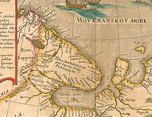
The Barents Sea was formerly known to Russians as
Murmanskoye Morye, or the "Sea of Murmans" (i.e., Norwegians), and it appears with this name in sixteenth-century maps, including Gerard Mercator's
Map of the Arctic published in his 1595 atlas. Its eastern corner, in the region of the
Pechora RiverThe Pechora River is a river in northwest Russia which flows north into the Arctic Ocean on the west side of the Ural Mountains. It lies mostly in the Komi Republic but the northernmost part crosses the Nenets Autonomous Okrug. It is 1,809 km long and its basin is 322,000 square kilometers...
's estuary, has been known as
Pechorskoye Morye, that is,
Pechora SeaPechora Sea , is a sea at the northwest of Russia, the southeastern part of the Barents Sea. The western border of the sea is off Kolguyev Island, while the eastern border is the western coasts of Vaygach Island and the Yugorsky Peninsula, and the northern border the southern end of Novaya...
.
This sea was given its present name in honor of
Willem BarentsWillem Barentsz was a Dutch navigator, cartographer, explorer, and a leader of early expeditions to the far north....
, a Dutch navigator and explorer. Barents was the leader of early expeditions to the far north, at the end of the sixteenth century. Seabed mapping was completed in 1933 with the first full map produced by Russian marine geologist
Maria KlenovaMaria Vasilyevna Klenova was a Russian and Soviet marine geologist and one of the founders of Russian marine science.Klenova studied to become a professor and later on worked as a member of the Council for Antarctic Research of the USSR Academy of Sciences...
.
The Barents Sea was also the site of a notable
World War IIWorld War II, or the Second World War , was a global conflict lasting from 1939 to 1945, involving most of the world's nations—including all of the great powers—eventually forming two opposing military alliances: the Allies and the Axis...
engagement, a German surface merchant raiding attack on a British convoy that later became known as the
Battle of the Barents SeaThe Battle of the Barents Sea took place on 31 December 1942 between German surface raiders and British ships escorting convoy JW 51B to Kola Inlet in the USSR. The action took place in the Barents Sea north of North Cape, Norway...
. Under the command of
Oskar KummetzOskar Kummetz was a Generaladmiral with the Kriegsmarine during World War II. He also served in the Kaiserliche Marine during World War I. Kummetz was awarded the Knight's Cross of the Iron Cross for his actions in the Battle of Drøbak Sound, during which his command, the was sunk by Norwegian...
, the German warships sink minelayer HMS
Bramble and destroyer , but in turn lost destroyer and has severely damaged by British gunfire. The Germans later retreated and the British convoy arrived safely at Murmansk shortly afterwards.
During the
Cold WarThe Cold War was the continuing state from roughly 1946 to 1991 of political conflict, military tension, proxy wars, and economic competition between the Communist World—primarily the Soviet Union and its satellite states and allies—and the powers of the Western world, primarily the United States...
, the Soviet Red Banner Northern Fleet used the southern reaches of the Sea as a ballistic missile submarine
bastionA bastion in naval strategy is a heavily-defended area of water in which friendly naval forces can operate safely. Typically, that area will be partially enclosed by friendly shoreline, defended by naval mines, monitored by sensors, and heavily patrolled by surface, submarine, and air forces.-...
, a strategy that
RussiaRussia or , officially known as both Russia and the Russian Federation , is a country in northern Eurasia. It is a federal semi-presidential republic, comprising 83 federal subjects...
continues. Nuclear contamination from dumped Russian naval
reactorsA nuclear reactor is a device to initiate and control a sustained nuclear chain reaction. Most commonly they are used for generating electricity and for the propulsion of ships. Usually heat from nuclear fission is passed to a working fluid , which runs through turbines that power either ship's...
is an
environmentalThe natural environment encompasses all living and non-living things occurring naturally on Earth or some region thereof. It is an environment that encompasses the interaction of all living species....
concern in the Barents Sea.
Oil explorationHydrocarbon exploration is the search by petroleum geologists and geophysicists for hydrocarbon deposits beneath the Earth's surface, such as oil and natural gas...
in the Barents Sea began in the 1970s. Discoveries were made on both the Russian and Norwegian sides. The first major producing field will be
SnøhvitSnøhvit is the name of a natural gas field in the Norwegian Sea, situated northwest of Hammerfest, Norway. The northern part of the Norwegian Sea is often described as the Barents Sea by offshore petroleum companies...
in the Norwegian sector. The largest discovery to date is the
Shtokman fieldThe Shtokman field , one of the world's largest natural gas fields, lies in the central part of Russian sector of the Barents Sea, north of Kola Peninsula. Its reserves are estimated at of natural gas and more than 37 million tons of gas condensate.-History:The Shtokman field was discovered...
in the Russian sector. For decades there was a
boundaryThe border between Russia and Norway, formerly the border between the Soviet Union and the NATO member state Norway, consists of a long land borderline, from the Finnish border to the coastline at Grense Jakobselv in northernmost Norway and north-west Russia, and a maritime border which extends...
dispute between Norway and Russia, with the Norwegians favouring the Median Line and the Russians favouring a
meridianA meridian is an imaginary line on the Earth's surface from the North Pole to the South Pole that connects all locations along it with a given longitude. The position of a point along the meridian is given by its latitude. Each meridian is perpendicular to all circles of latitude...
based sector. A compromise treaty announced 27 April 2010 settled the border in the approximate middle of these two stances.
External links
The source of this article is
wikipedia, the free encyclopedia. The text of this article is licensed under the
GFDL.