

2008 Indian floods
Encyclopedia
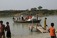
The 2008 Indian floods were a series of floods in various states of India
during the 2008 monsoon
season. The floods mostly affected the western regions of Maharashtra
state and Andhra Pradesh
as well as northern Bihar
. In India, the monsoon season generally lasts from June to September.
According to Ministry of Home Affairs (India)
's disaster management unit, countrywide death toll from floods in various state was 2,404 between June to September.
and Orissa
were hit with heavy rains, creating a flood-like situation in the two states. The monsoon killed 100 people, mostly in the country's east and north-east. In Andhra Pradesh alone, 42 people died in a matter of two days because of sudden, heavy rains.
region of Maharashtra
experienced heavy monsoon rains, placing lives in jeopardy. Many inter-city trains between Mumbai
and Pune
were cancelled. Heavy waterlogging had been reported from Chiplun
, Rajapur, Khed
and Mahad
in Maharashtra. On 10 August 2008, a major landslide
caused extensive damage to a three-story building at the Sinhgad Technical Education Society
's (STES) academic campus in Lonavla. A large number of passengers were reportedly stranded at various railway stations across western Maharashtra as Central Railways canceled many trains. Vehicular traffic on the Mumbai-Pune expressway
was also affected due to heavy rainfall and was diverted.
In Mumbai
, heavy rains lashed the city and its suburbs, affecting traffic
and disrupting rail services on the days of 10–11 August.
In Andhra Pradesh 119 relief camps were set up in the state, most of them in the Guntur
and Krishna district
s. Hyderabad, Krishna district, and the East and West Godavari districts were the worst affected areas due to floods. The situation in Andhra Pradesh was more deadly as 53 people reportedly died due to floods. In Hyderabad alone 14 people were killed, when they were crushed by the collapsing roofs of their homes.
 The nexus of the Bihar flood is the Kosi River's immense alluvial fan
, extending some 185 km from the river's exit from the Himalayas
and foothills
in Nepal
, down to its confluence with the Ganges in Bihar
. The laws of geology and physics cause rivers to course back and forth across such fans in ephemeral channels lasting decades at most, but for flood control reasons man-made embankments endeavored to contain the Koshi within a channel along its fan's western edge. On 18 August, heavy monsoon rains caused the river to break out of this channel. It started flowing through an old channel much further east, inundating cropland and towns and villages with 1.2 million inhabitants, mostly in Bihar.
Chief Minister of Bihar Nitish Kumar
met India Prime Minister Manmohan Singh
to seek his help in dealing with the "catastrophe". The worst affected districts included Supaul
, Madhepura
, north Bhagalpur
, Araria
, Purnia
(all by the Kosi) and West Champaran
(by Gandak). Relief work was carried with Indian Air Force
helicopters dropping relief materials in the worst hit districts.
The district magistrate of Madhepura
has ordered the inhabitants of the town of Madhepura to evacuate because the water level continued to rise. Relief work was carried with Indian Air Force
helicopters dropping relief materials (including 600 food packets per day) from Purnia in the worst hit districts where nearly two million persons were entrapped.
It is not possible to assess the magnitude of deaths or destruction, because the affected areas are totally inaccessible. Even mobile phone
s had stopped working, because entrapped persons cannot get their batteries charged. 150 persons were washed away in a single incident (Dainik Hindustan, Darbhanga edition). Another report says 42 people have died in the flood in Bihar.
The Government of Bihar
has constituted a technical committee, headed by retired engineer-in-chief of the water resource department, Nilendu Sanyal, to manage the restoration work and closure of the breach in the East Koshi afflux embankment. Indian authorities were working to prevent further widening of the breach and channels would be dug to direct the water back to the main river bed. However, Dainik Hindustan (Darbhanga edition) reported on Aug 28 that Indian officials were chased away by anti-social elements from the breach site in Nepal. Nepal's Defence Minister has made a statement that Nepal will repair the breach on its own, although it was not made clear when this work will be started.
Dainik Hindustan (Darbhanga edition) later sent its reporter to the site of the Kushaha breach, who reported with photographs on Sep 5 that all earlier claims by government officials of repairing the breach and of Nepalis chasing away Indian officials were utterly false reports by Indian officials, because there were thick forests on the embankment and it was not possible to reach the site before the end of August. Forest on the embankment proves that these parts of Kosi embankments were not even visited for decades. Its maintenance was the responsibility of Indian, especially Bihar's officials. The life of these embankments elapsed over two decades ago, but no effort was taken to even survey their conditions, although the Bihar government spends huge sums on the maintenance of embankments each year.
A high-level Government of Nepal
team that inspected areas devastated by the flood in the Koshi River
has held India responsible for the havoc. Media reports stated The devastation took place as the Indian side did not carry out repair and maintenance work on the Kosi barrage and the embankment along the river, thereby violating the Nepal-India Koshi agreement. As per the bilateral agreement of 1954 India is entirely responsible for repair and maintenance work and operation of the barrage. There was no effort by Indian officials to repair the breach in time, although the Kosi took 15 days to make the breach.
On the other hand, Indian engineers say that anti-social elements in Nepal did not allow them to repair the embankment (Dainik Hindustan, Darbhanga edition, Aug 28). These so-called "anti-social" elements are the victims of the Kosi embankments who have been forced to bear tsunami-like floods every year; they are happy that the river wants to change its course. Kosi embankments are designed to contain the Kosi in the channel of the Tilyuga River, while the old course of the Kosi lies far to the east in Purnia district. Later, Dainik Hindustan reported on Sep 5 that Indian officials could not reach the site of breach as there were forests on the embankment which were cleared in early September, hence Indian officials were lying about being prevented to repair the breach: they had not visited the site for decades due to forests in the way.
The New York Times reported that it is the worst flood in the area in 50 years, prompting Manmohan Singh
to declare a “national calamity” on 28 August. The government earmarked US$230 million in aid for the region. The Indian Army, National Disaster Response Force (NDRF)
and non-governmental organizations operated the biggest flood rescue operation in India in more than 50 years. Death tolls rose from Indian floods as more than 65 people had been killed in monsoon rains. Villagers ate raw rice and flour mixed with polluted water in Bihar
, amid hunger and diseases. Supaul
district was the worst-hit by floods and surging waters swamped 1000 square kilometres (247,105.2 acre) of farmlands, destroying wheat and paddy crops.
faced floods with rising waters from the Brahmaputra River
. Kaziranga National Park
, which has the highest density of rhinos
in the world, was 90% submerged in water. Also, Pobitra national park in Assam was flooded. Two rhinos have died in these floods. A tiger has killed one rhino calf. In addition, four deer and one elephant have also failed to survive.
The flood situation has affected estimated 2.1 million people and caused 24 deaths so far. Worst affected districts are Dhubri
, Jorhat
, Kamrup
, Lakhimpur, Dhemaji
and Morigaon. Thousands of people are staying in makeshift shelters with the government providing food and other essentials to the displaced people, besides healthcare facilities. Indian officials say that the flooding situation could cause an epidemic
, because refugees are consuming unclean water and food in shelters.
Breaches in embankments have caused these floods in Assam. Four embankments on the Puthimari River, one constructed just three months ago, were breached causing the calamity. Waters have breached embankments at total 54 vital locations, and water level
s are dangerously high in about 10 points.
The Irish
government is sending €350,000 (Rs. 22.3 million) in aid to the victims of the floods.
Eastern Orissa
state and most populous northern state Uttar Pradesh
were flooded heavily causing more than 150 deaths from September 19 to September 22. Army has reached in UP
to rescue at least a quarter million people and food packets have been supplied to the rescued.
India
India , officially the Republic of India , is a country in South Asia. It is the seventh-largest country by geographical area, the second-most populous country with over 1.2 billion people, and the most populous democracy in the world...
during the 2008 monsoon
Monsoon
Monsoon is traditionally defined as a seasonal reversing wind accompanied by corresponding changes in precipitation, but is now used to describe seasonal changes in atmospheric circulation and precipitation associated with the asymmetric heating of land and sea...
season. The floods mostly affected the western regions of Maharashtra
Maharashtra
Maharashtra is a state located in India. It is the second most populous after Uttar Pradesh and third largest state by area in India...
state and Andhra Pradesh
Andhra Pradesh
Andhra Pradesh , is one of the 28 states of India, situated on the southeastern coast of India. It is India's fourth largest state by area and fifth largest by population. Its capital and largest city by population is Hyderabad.The total GDP of Andhra Pradesh is $100 billion and is ranked third...
as well as northern Bihar
Bihar
Bihar is a state in eastern India. It is the 12th largest state in terms of geographical size at and 3rd largest by population. Almost 58% of Biharis are below the age of 25, which is the highest proportion in India....
. In India, the monsoon season generally lasts from June to September.
According to Ministry of Home Affairs (India)
Ministry of Home Affairs (India)
Ministry of Home Affairs , known as the Home Ministry or MHA, is an Indian government ministry. It is an interior ministry mainly responsible for the maintenance of Internal security and domestic policy.-Ministerial Team:...
's disaster management unit, countrywide death toll from floods in various state was 2,404 between June to September.
Early monsoon
Earlier, during the start of the monsoon season, West BengalWest Bengal
West Bengal is a state in the eastern region of India and is the nation's fourth-most populous. It is also the seventh-most populous sub-national entity in the world, with over 91 million inhabitants. A major agricultural producer, West Bengal is the sixth-largest contributor to India's GDP...
and Orissa
Orissa
Orissa , officially Odisha since Nov 2011, is a state of India, located on the east coast of India, by the Bay of Bengal. It is the modern name of the ancient nation of Kalinga, which was invaded by the Maurya Emperor Ashoka in 261 BC. The modern state of Orissa was established on 1 April...
were hit with heavy rains, creating a flood-like situation in the two states. The monsoon killed 100 people, mostly in the country's east and north-east. In Andhra Pradesh alone, 42 people died in a matter of two days because of sudden, heavy rains.
August flooding
In August, the KonkanKonkan
The Konkan also called the Konkan Coast or Karavali is a rugged section of the western coastline of India from Raigad to Mangalore...
region of Maharashtra
Maharashtra
Maharashtra is a state located in India. It is the second most populous after Uttar Pradesh and third largest state by area in India...
experienced heavy monsoon rains, placing lives in jeopardy. Many inter-city trains between Mumbai
Mumbai
Mumbai , formerly known as Bombay in English, is the capital of the Indian state of Maharashtra. It is the most populous city in India, and the fourth most populous city in the world, with a total metropolitan area population of approximately 20.5 million...
and Pune
Pune
Pune , is the eighth largest metropolis in India, the second largest in the state of Maharashtra after Mumbai, and the largest city in the Western Ghats. Once the centre of power of the Maratha Empire, it is situated 560 metres above sea level on the Deccan plateau at the confluence of the Mula ...
were cancelled. Heavy waterlogging had been reported from Chiplun
Chiplun
Chiplun is a city and a municipal council in Ratnagiri district in the state of Maharashtra, India. Located on the Mumbai–Goa highway in western India. The city is about 320 km south of Mumbai in the Konkan region of Maharashtra. It is a fast developing city in Konkan with a strong cultural...
, Rajapur, Khed
Khed
Khed is an industrial city with a municipal council in Ratnagiri district in the state of Maharashtra, India. It is surrounded by a number of villages, including Khopi, Savnas, Bahirwali, Furus, Karji, Tise, Rajawel, Panhalje, Lote, Kondivali, Shiv, Mani, Nandgaon, Ashti, Shirgaon, Sakhroli,...
and Mahad
Mahad
Mahad is a city and a municipal council in Raigad district in the Indian state of Maharashtra. It is situated about 175 km to the south of Mumbai . It has become the center of attraction because of its beautiful surroundings and pleasant climate. Mahad has a personality of its own due to its...
in Maharashtra. On 10 August 2008, a major landslide
Landslide
A landslide or landslip is a geological phenomenon which includes a wide range of ground movement, such as rockfalls, deep failure of slopes and shallow debris flows, which can occur in offshore, coastal and onshore environments...
caused extensive damage to a three-story building at the Sinhgad Technical Education Society
Sinhgad Technical Education Society
Sinhgad Technical Education Society, also referred to as STES, is a collection of education institutes operating mainly in the region of Pune, India. It provides education in the fields of Engineering, Management, Pharmacy, Architecture, and Computer Applications.STES was founded by Prof. M. N...
's (STES) academic campus in Lonavla. A large number of passengers were reportedly stranded at various railway stations across western Maharashtra as Central Railways canceled many trains. Vehicular traffic on the Mumbai-Pune expressway
Mumbai-Pune Expressway
The Mumbai Pune Expressway , officially the Yashwantrao Chavan Expressway is India's first six-lane concrete, high-speed, access controlled tolled expressway. It spans a distance of connecting Mumbai, the administrative capital of Maharashtra and the financial capital of India, with Pune, an...
was also affected due to heavy rainfall and was diverted.
In Mumbai
Mumbai
Mumbai , formerly known as Bombay in English, is the capital of the Indian state of Maharashtra. It is the most populous city in India, and the fourth most populous city in the world, with a total metropolitan area population of approximately 20.5 million...
, heavy rains lashed the city and its suburbs, affecting traffic
Traffic
Traffic on roads may consist of pedestrians, ridden or herded animals, vehicles, streetcars and other conveyances, either singly or together, while using the public way for purposes of travel...
and disrupting rail services on the days of 10–11 August.
In Andhra Pradesh 119 relief camps were set up in the state, most of them in the Guntur
Guntur
Guntur , is a city and a municipal corporation in the Indian state of Andhra Pradesh, located to the north and west of the Bay of Bengal. It is approximately to the south of the national capital, New Delhi and south east of state capital, Hyderabad. Guntur is the fourth largest city in Andhra...
and Krishna district
Krishna district
Krishna District is a district of India's Andhra Pradesh state. It is named after the Krishna River, the third longest river that flows within India, flows through the district and joins Bay of Bengal here in this district. It has a population of 4,529,009 of which 32.08% is urban as of...
s. Hyderabad, Krishna district, and the East and West Godavari districts were the worst affected areas due to floods. The situation in Andhra Pradesh was more deadly as 53 people reportedly died due to floods. In Hyderabad alone 14 people were killed, when they were crushed by the collapsing roofs of their homes.
Bihar
Alluvial fan
An alluvial fan is a fan-shaped deposit formed where a fast flowing stream flattens, slows, and spreads typically at the exit of a canyon onto a flatter plain. A convergence of neighboring alluvial fans into a single apron of deposits against a slope is called a bajada, or compound alluvial...
, extending some 185 km from the river's exit from the Himalayas
Himalayas
The Himalaya Range or Himalaya Mountains Sanskrit: Devanagari: हिमालय, literally "abode of snow"), usually called the Himalayas or Himalaya for short, is a mountain range in Asia, separating the Indian subcontinent from the Tibetan Plateau...
and foothills
Mahabharat Lekh
The Mahabharat Range -- also called the Lesser Himalaya -- is a major east-west mountain range [a series of east-west mountain ranges] with elevations 1,500 to 2,700 metres along the crest, paralleling the much higher Great Himalaya range from the Indus River in Pakistan across northern India,...
in Nepal
Geography of Nepal
Nepal measures about along its himalayan axis by across. With it slightly outranks Bangladesh or the state of Arkansas. Nepal is landlocked by India on three sides and China's Xizang Autonomous Region to the north. West Bengal's narrow Siliguri Corridor or Chicken's Neck separate Nepal and...
, down to its confluence with the Ganges in Bihar
Bihar
Bihar is a state in eastern India. It is the 12th largest state in terms of geographical size at and 3rd largest by population. Almost 58% of Biharis are below the age of 25, which is the highest proportion in India....
. The laws of geology and physics cause rivers to course back and forth across such fans in ephemeral channels lasting decades at most, but for flood control reasons man-made embankments endeavored to contain the Koshi within a channel along its fan's western edge. On 18 August, heavy monsoon rains caused the river to break out of this channel. It started flowing through an old channel much further east, inundating cropland and towns and villages with 1.2 million inhabitants, mostly in Bihar.
Chief Minister of Bihar Nitish Kumar
Nitish Kumar
Nitish Kumār is an Indian politician currently serving as Chief Minister of Bihar, an eastern state of India. He leads the Janata Dal party...
met India Prime Minister Manmohan Singh
Manmohan Singh
Manmohan Singh is the 13th and current Prime Minister of India. He is the only Prime Minister since Jawaharlal Nehru to return to power after completing a full five-year term. A Sikh, he is the first non-Hindu to occupy the office. Singh is also the 7th Prime Minister belonging to the Indian...
to seek his help in dealing with the "catastrophe". The worst affected districts included Supaul
Supaul
Supaul is a town and a municipality that is headquarters of Supaul district in the Indian state of Bihar. Not far from this place is the Indian border connecting Nepal. The Supaul Town is the administrative headquarters of this district....
, Madhepura
Madhepura
Madhepura is a city and a municipality in Madhepura district in the Indian state of Bihar. Madhepura as it stands now was carved out of Saharsa district and got the status of revenue district on 9 May 1981. Prior to that, Madhepura was a sub-division under Bhagalpur district with effect from 3...
, north Bhagalpur
Bhagalpur
Bhagdattpuram was one of the most influential towns in "Aryavarta" . It is supposed to have been concurrent to Patliputra or Patna. Bhagdattpuram finds its mention in the Vedas and Ramayana as well. It is supposed to be the kingdom of Daanvir Karna, the son of Kunti and the Sun God...
, Araria
Araria
Araria is a town and a municipality that is headquarters of Araria district in the state of Bihar, India.-Geography:Araria is located at . It has an average elevation of 47 metres . Araria is situated at the northern part of Purnia and Madhepura in Bihar...
, Purnia
Purnia
Purnia is a city and a Municipal Corporation in Purnia district of the Indian state of Bihar. It is located 400 km from Patna.The Indian army, Border Security Force ,and the SSB and the have bases around the city...
(all by the Kosi) and West Champaran
West Champaran
West Champaran is an administrative district in the state of Bihar in India. It is a part of Tirhut Division. The district headquarters are located at Bettiah....
(by Gandak). Relief work was carried with Indian Air Force
Indian Air Force
The Indian Air Force is the air arm of the Indian armed forces. Its primary responsibility is to secure Indian airspace and to conduct aerial warfare during a conflict...
helicopters dropping relief materials in the worst hit districts.
The district magistrate of Madhepura
Madhepura
Madhepura is a city and a municipality in Madhepura district in the Indian state of Bihar. Madhepura as it stands now was carved out of Saharsa district and got the status of revenue district on 9 May 1981. Prior to that, Madhepura was a sub-division under Bhagalpur district with effect from 3...
has ordered the inhabitants of the town of Madhepura to evacuate because the water level continued to rise. Relief work was carried with Indian Air Force
Indian Air Force
The Indian Air Force is the air arm of the Indian armed forces. Its primary responsibility is to secure Indian airspace and to conduct aerial warfare during a conflict...
helicopters dropping relief materials (including 600 food packets per day) from Purnia in the worst hit districts where nearly two million persons were entrapped.
It is not possible to assess the magnitude of deaths or destruction, because the affected areas are totally inaccessible. Even mobile phone
Mobile phone
A mobile phone is a device which can make and receive telephone calls over a radio link whilst moving around a wide geographic area. It does so by connecting to a cellular network provided by a mobile network operator...
s had stopped working, because entrapped persons cannot get their batteries charged. 150 persons were washed away in a single incident (Dainik Hindustan, Darbhanga edition). Another report says 42 people have died in the flood in Bihar.
The Government of Bihar
Government of Bihar
The Government of Bihar, known locally as State Government, is the supreme governing authority of the Indian state of Bihar and its 38 districts of its divisions...
has constituted a technical committee, headed by retired engineer-in-chief of the water resource department, Nilendu Sanyal, to manage the restoration work and closure of the breach in the East Koshi afflux embankment. Indian authorities were working to prevent further widening of the breach and channels would be dug to direct the water back to the main river bed. However, Dainik Hindustan (Darbhanga edition) reported on Aug 28 that Indian officials were chased away by anti-social elements from the breach site in Nepal. Nepal's Defence Minister has made a statement that Nepal will repair the breach on its own, although it was not made clear when this work will be started.
Dainik Hindustan (Darbhanga edition) later sent its reporter to the site of the Kushaha breach, who reported with photographs on Sep 5 that all earlier claims by government officials of repairing the breach and of Nepalis chasing away Indian officials were utterly false reports by Indian officials, because there were thick forests on the embankment and it was not possible to reach the site before the end of August. Forest on the embankment proves that these parts of Kosi embankments were not even visited for decades. Its maintenance was the responsibility of Indian, especially Bihar's officials. The life of these embankments elapsed over two decades ago, but no effort was taken to even survey their conditions, although the Bihar government spends huge sums on the maintenance of embankments each year.
A high-level Government of Nepal
Government of Nepal
The Government of Nepal, or Nepal Government, is the executive body and the Central government of Nepal. Prior to the abolition of Monarchy in Nepal, was officially known as His Majesty's Government....
team that inspected areas devastated by the flood in the Koshi River
Koshi River
The Kosi River or Koshi —also Saptakoshi for its seven Himalayan tributaries—is a trans-boundary river flowing through Nepal and India. Some of the rivers of the Koshi system, such as the Arun, the Sun Kosi and the Bhote Koshi, originate in the Tibet Autonomous Region of China...
has held India responsible for the havoc. Media reports stated The devastation took place as the Indian side did not carry out repair and maintenance work on the Kosi barrage and the embankment along the river, thereby violating the Nepal-India Koshi agreement. As per the bilateral agreement of 1954 India is entirely responsible for repair and maintenance work and operation of the barrage. There was no effort by Indian officials to repair the breach in time, although the Kosi took 15 days to make the breach.
On the other hand, Indian engineers say that anti-social elements in Nepal did not allow them to repair the embankment (Dainik Hindustan, Darbhanga edition, Aug 28). These so-called "anti-social" elements are the victims of the Kosi embankments who have been forced to bear tsunami-like floods every year; they are happy that the river wants to change its course. Kosi embankments are designed to contain the Kosi in the channel of the Tilyuga River, while the old course of the Kosi lies far to the east in Purnia district. Later, Dainik Hindustan reported on Sep 5 that Indian officials could not reach the site of breach as there were forests on the embankment which were cleared in early September, hence Indian officials were lying about being prevented to repair the breach: they had not visited the site for decades due to forests in the way.
The New York Times reported that it is the worst flood in the area in 50 years, prompting Manmohan Singh
Manmohan Singh
Manmohan Singh is the 13th and current Prime Minister of India. He is the only Prime Minister since Jawaharlal Nehru to return to power after completing a full five-year term. A Sikh, he is the first non-Hindu to occupy the office. Singh is also the 7th Prime Minister belonging to the Indian...
to declare a “national calamity” on 28 August. The government earmarked US$230 million in aid for the region. The Indian Army, National Disaster Response Force (NDRF)
National Disaster Response Force (NDRF)
The DM Act, 2005 has made the statutory provisions for the constitution of the National Disaster Response Force for the purpose of specialized response to natural and man-made disasters...
and non-governmental organizations operated the biggest flood rescue operation in India in more than 50 years. Death tolls rose from Indian floods as more than 65 people had been killed in monsoon rains. Villagers ate raw rice and flour mixed with polluted water in Bihar
Bihar
Bihar is a state in eastern India. It is the 12th largest state in terms of geographical size at and 3rd largest by population. Almost 58% of Biharis are below the age of 25, which is the highest proportion in India....
, amid hunger and diseases. Supaul
Supaul
Supaul is a town and a municipality that is headquarters of Supaul district in the Indian state of Bihar. Not far from this place is the Indian border connecting Nepal. The Supaul Town is the administrative headquarters of this district....
district was the worst-hit by floods and surging waters swamped 1000 square kilometres (247,105.2 acre) of farmlands, destroying wheat and paddy crops.
September flooding
In September, even as the Bihar floods had not receded completely, the north-eastern state of AssamAssam
Assam , also, rarely, Assam Valley and formerly the Assam Province , is a northeastern state of India and is one of the most culturally and geographically distinct regions of the country...
faced floods with rising waters from the Brahmaputra River
Brahmaputra River
The Brahmaputra , also called Tsangpo-Brahmaputra, is a trans-boundary river and one of the major rivers of Asia. It is the only Indian river that is attributed the masculine gender and thus referred to as a in Indo-Aryan languages and languages with Indo-Aryan influence...
. Kaziranga National Park
Kaziranga National Park
Kaziranga National Park is a national park in the Golaghat and Nagaon districts of the state of Assam, India. A World Heritage Site, the park hosts two-thirds of the world's Great One-horned Rhinoceroses. Kaziranga boasts the highest density of tigers among protected areas in the world and was...
, which has the highest density of rhinos
Rhinoceros
Rhinoceros , also known as rhino, is a group of five extant species of odd-toed ungulates in the family Rhinocerotidae. Two of these species are native to Africa and three to southern Asia....
in the world, was 90% submerged in water. Also, Pobitra national park in Assam was flooded. Two rhinos have died in these floods. A tiger has killed one rhino calf. In addition, four deer and one elephant have also failed to survive.
The flood situation has affected estimated 2.1 million people and caused 24 deaths so far. Worst affected districts are Dhubri
Dhubri
Dhubri is the headquarters of Dhubri district India. It is a small old town on the bank of the Brahmaputra and Gadadhar Rivers. In 1883, the town was first constituted as a Municipal Board and is situated about west from Guwahati, the state capital.Dhubri was an important commercial centre and...
, Jorhat
Jorhat
Jorhat is a city of Assam in India. Jorhat was established as a new capital in the closing years of the 18th century by the declining Tunkhungia Ahom Dynasty. Jorhat, as the name signifies, was just a couple of markets . Two parallel markets namely, Chowkihat and Macharhat, lay on the eastern...
, Kamrup
Kamrup
Kamrup district is an administrative district in the state of Assam in India, named after Kamarupa, a name by which Assam was previously known in ancient times. The district, however, is now a small western part of Assam, with a distinctive native Kamrupi culture and dialect . The distinctive...
, Lakhimpur, Dhemaji
Dhemaji
Dhemaji is the headquarters of Dhemaji district, Assam, India. It is one of the remotest districts of Assam. From the State Capital , it takes about 10 hours by road to reach Dhemaji. Dhemaji is a very flood-prone district. For a few days it remains cut off from the rest of the country every year...
and Morigaon. Thousands of people are staying in makeshift shelters with the government providing food and other essentials to the displaced people, besides healthcare facilities. Indian officials say that the flooding situation could cause an epidemic
Epidemic
In epidemiology, an epidemic , occurs when new cases of a certain disease, in a given human population, and during a given period, substantially exceed what is expected based on recent experience...
, because refugees are consuming unclean water and food in shelters.
Breaches in embankments have caused these floods in Assam. Four embankments on the Puthimari River, one constructed just three months ago, were breached causing the calamity. Waters have breached embankments at total 54 vital locations, and water level
Water level
Water level or gage height or stage is the elevation of the free surface of a stream, lake or reservoir relative to a specified datum ....
s are dangerously high in about 10 points.
The Irish
Republic of Ireland
Ireland , described as the Republic of Ireland , is a sovereign state in Europe occupying approximately five-sixths of the island of the same name. Its capital is Dublin. Ireland, which had a population of 4.58 million in 2011, is a constitutional republic governed as a parliamentary democracy,...
government is sending €350,000 (Rs. 22.3 million) in aid to the victims of the floods.
Eastern Orissa
Orissa
Orissa , officially Odisha since Nov 2011, is a state of India, located on the east coast of India, by the Bay of Bengal. It is the modern name of the ancient nation of Kalinga, which was invaded by the Maurya Emperor Ashoka in 261 BC. The modern state of Orissa was established on 1 April...
state and most populous northern state Uttar Pradesh
Uttar Pradesh
Uttar Pradesh abbreviation U.P. , is a state located in the northern part of India. With a population of over 200 million people, it is India's most populous state, as well as the world's most populous sub-national entity...
were flooded heavily causing more than 150 deaths from September 19 to September 22. Army has reached in UP
Uttar Pradesh
Uttar Pradesh abbreviation U.P. , is a state located in the northern part of India. With a population of over 200 million people, it is India's most populous state, as well as the world's most populous sub-national entity...
to rescue at least a quarter million people and food packets have been supplied to the rescued.