
1959 Yellowstone earthquake
Encyclopedia
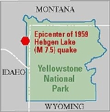
The 1959 Yellowstone earthquake also known as the Hebgen Lake earthquake was a powerful earthquake
that occurred on August 17, 1959 at 11:37 pm (MST) in southwestern Montana
. The earthquake was registered at magnitude 7.3 – 7.5 on the Richter scale
. The quake caused a huge landslide that caused over 28 fatalities and left $11 million (1959 USD, $74.1 million 2006 USD) in damage and also blocked the flow of the Madison River
resulting in the creation of Quake Lake
. Effects of the earthquake were also felt in Idaho
and Wyoming
.
The 1959 quake was the strongest and deadliest earthquake to hit Montana
since the 1935-36 Helena
earthquakes left 4 people dead. It also caused the worst landslides in the history of the Northwestern United States
since 1927.
. Several nearby campgrounds were occupied by vacationing campers and tourists at the time the quake struck.
s to surge across Hebgen Lake
for 12 hours. Water pushed by the seiches poured over the dam which did not collapse. Several aftershocks ranging from 5.8 to 6.3 were reported after the quake.
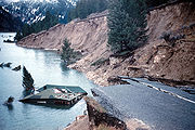 The landslides caused by the quake carried 80 million tons (40 million cubic yards) of rock, mud and debris down into the valley and created hurricane force winds strong enough to toss cars. In Madison Canyon, a family of seven were swept away by the landslide, five of whom perished. Two more fatalities were also reported in nearby Cliff Lake to the south. In Rock Creek, tourists camping there were caught off guard by the quake and landslide, which swept them into the creek by causing a seiche
which inundated trailers and tents, uprooted trees, and injured one additional person. In nearby Yellowstone National Park
, new geysers and cracks sprouted up over the park.
In Yellowstone National Park
near Old Faithful, the earthquake damaged the Old Faithful Inn
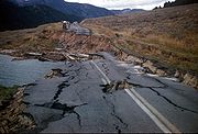
, forcing guests there to evacuate. Landslides caused by the quake blocked a road between Mammoth and Old Faithful, damaging a bridge inside the park. There was one reported injury when a woman broke her wrist in the quake. The earthquake also created fault scarp
s as high as six meters, causing extensive damage to roads, homes and buildings. In Belgrade, the earthquake damaged measuring equipment placed in a 100 feet (30.5 m) water well. The quake also knocked out telephone communications between Bozeman
and Yellowstone, with the City of Bozeman itself suffering moderate quake damage to homes and buildings. Buildings at the Montana State College
campus also sustained quake damage. In Butte
, the quake caused a pendulum clock to stop at 12:42 a.m. (MST) and caused minor damage to homes.
Areas around Hebgen Lake
were also hard hit as the quake caused parts of the lake to rise eight feet. Roads and highways running along coastal sections of the lake collapsed into the water. In Ennis
, majority of the residents there evacuated due to the threat that water from Hebgen Lake
might flood the town. The evacuation was called off when the landslide blocked the river preventing the water from flowing. In West Yellowstone
, the earthquake damaged a courthouse and a railroad station.
The earthquake also caused damage and fatalities outside of Montana
. In Raynolds Pass
in Eastern Idaho
, a landslide killed eight more people. Seismic waves from the quake were reported in Boise
and Macks Inn, Idaho. The quake there caused minor well and sewer damage. Residents in Utah also felt the quake. In Salt Lake County, Utah
, police officers at the local jail and officials at the Salt Lake Municipal Airport felt the effects of the earthquake. In Puerto Rico
, the distant effects of the earthquake caused water in wells to drop .01 ft (.003 meters). The final death toll from the earthquake was 28 although some newspaper reports suggested the death toll is high as 50-60. and $11 million (1959 USD, $74.1 million 2006 USD) in damage.
 Amateur radio
operator K7ICM transmitted news of the quake at 11:43 p.m. (MST). At 11:50 p.m., another amateur in Idaho
contacted the Idaho State Police
who in turn contacted their headquarters in Boise
. The Montana Highway Patrol
, Montana State Civil Defense
and the Montana Fish, Wildlife & Parks Department also received word of the earthquake and its effects. The geography of the area plus the damage from the earthquake disrupted and/or obstructed radio communications, making broadcasting accurate information about the quakes effects difficult.
The American Red Cross
, The Yellowstone County Chapter, Salvation Army
and various other states, local and national organisations sent aid to the victims of the earthquake. The Red Cross also set up temporary housing in Bozeman
and the Wyoming Department of Health
sent 200 trailers to the Yellowstone area to be used as hospitals. Because the majority of the roads in and around the Yellowstone area were either damaged or blocked by the landslides and the quake, equipment and personnel from the United States Air Force
and the U.S. Forest Service were brought in to transport the injured to nearby hospitals outside the quake zone and to perform search and rescue missions in Madison Canyon. 300 people trapped in the canyon were rescued. Rescuers found five to nine bodies in the earthquake zone. Residents from the town of Ennis
, were evacuated to Virginia City
and Butte
.
Senators and Representatives Frank Moss (D-Utah), John Baldwin
(R-California), Harold Johnson
(D-California), Lee Metcalf
(D-Montana), Leroy Anderson (D-Montana), Tom Morris (D-New Mexico) and Gracie Pfost
(D-Idaho) overflew and surveyed the disaster area. The Senate Interior and Insular Affairs Committee requested Montana Governor J. Hugo Aronson
to declare the areas hardest hit by the quake a disaster area. Wyoming Governor John J. Hickey
provided help and equipment in the aftermath of the quake. The Montana National Guard
was called to the quake area to prevent looting of campsites left abandoned by the quake. The Idaho National Guard
were also sent to the quake area. The Montana Highway Department began clearing roads of debris and mud. The work was slowed by aftershocks and smaller landslides. On August 19, US Highway 20 and US Highway 191 were reopened while Montana State Highway 1 remained closed. Three bridges in Duck Creek, Cougar Creek and Madison Canyon were repaired and reopened as well. Because of the threat of gasoline
spilling into the Missouri River
, the a local pipeline company built an emergency pumping station The Montana Power Company
surveyed Hebgen Dam
and found it sustained minimal damage. Hebgen Lake was completely drained for crewmen to make repairs and to rid of dead or dying fish. Overall repairs to the Yellowstone National Park amounted to $2.6 million (1959 USD).
50 people including police officer
s, members of the Red Cross and others held a memorial service a mile north of the slide in Madison Canyon for campers presumed buried under the quake induced landslide. The services lasted for 15 minutes. After the quake, the U.S. Forest Service built the Quake Lake visitor center on top of the landslide which was completed in 1967. The U.S. Forest Service placed a plaque on one of the boulders that fell during the quake to honor the 19-21 people who were killed during the quake induced landslide.
. The blockage caused the water to rise and formed a new lake, which was later to be named Quake Lake
. Fearing that the pressure caused by the rising water would result in a catastrophic flood, the Army Corps of Engineers began to cut a 250 ft (76.2 m) wide and 14 ft (4.3 m) deep channel into the slide. By September 10, water began to flow through the channel. To prevent more erosion by the flowing water, the Army Corps cut another 50 ft (15.2 m) (15.2 m) channel which was completed on October 29. The construction of the two channels cost $1.7 million (1959 USD).
recorded the quake at both 7.3 and 7.5 on the Richter scale, while other seismographs recorded the quake at 7.8), the 1959 earthquake is comparable to the 1906 San Francisco earthquake
as one of the strongest earthquakes in North America
, behind the 1964 magnitude 9.2 Good Friday Earthquake
in Alaska. The 1959 earthquake is also the most severe earthquake in the Rocky Mountain area of the United States along with the 7.3 magnitude earthquake which struck Idaho
in 1983. The landslide caused by quake was the largest since an earthquake in Wyoming
in 1925 caused a landslide amounting to 50000000 cubic yards (38,227,742.9 m³) of rock and debris that left 28 people dead. The death toll from the quake was also the highest since the 1925 earthquake and most recent for the Northwestern United States
since an earthquake in 1927 that left seven people dead. The 1959 earthquake was also the most damaging earthquake to occur in Montana
since the 1935-36 earthquakes that left four people dead. The Hebgen Lake
area also experienced earthquakes again in 1964, 1974, 1977 and 1985.
Earthquake
An earthquake is the result of a sudden release of energy in the Earth's crust that creates seismic waves. The seismicity, seismism or seismic activity of an area refers to the frequency, type and size of earthquakes experienced over a period of time...
that occurred on August 17, 1959 at 11:37 pm (MST) in southwestern Montana
Montana
Montana is a state in the Western United States. The western third of Montana contains numerous mountain ranges. Smaller, "island ranges" are found in the central third of the state, for a total of 77 named ranges of the Rocky Mountains. This geographical fact is reflected in the state's name,...
. The earthquake was registered at magnitude 7.3 – 7.5 on the Richter scale
Richter magnitude scale
The expression Richter magnitude scale refers to a number of ways to assign a single number to quantify the energy contained in an earthquake....
. The quake caused a huge landslide that caused over 28 fatalities and left $11 million (1959 USD, $74.1 million 2006 USD) in damage and also blocked the flow of the Madison River
Madison River
The Madison River is a headwater tributary of the Missouri River, approximately 183 miles long, in Wyoming and Montana. Its confluence with the Jefferson and Gallatin rivers near Three Forks, Montana form the Missouri River....
resulting in the creation of Quake Lake
Quake Lake
Quake Lake is a lake in southwestern Montana, United States. It was created after a massive earthquake struck on August 17, 1959, which killed 27 people. Today, Quake Lake is 190 feet deep and six miles long...
. Effects of the earthquake were also felt in Idaho
Idaho
Idaho is a state in the Rocky Mountain area of the United States. The state's largest city and capital is Boise. Residents are called "Idahoans". Idaho was admitted to the Union on July 3, 1890, as the 43rd state....
and Wyoming
Wyoming
Wyoming is a state in the mountain region of the Western United States. The western two thirds of the state is covered mostly with the mountain ranges and rangelands in the foothills of the Eastern Rocky Mountains, while the eastern third of the state is high elevation prairie known as the High...
.
The 1959 quake was the strongest and deadliest earthquake to hit Montana
Montana
Montana is a state in the Western United States. The western third of Montana contains numerous mountain ranges. Smaller, "island ranges" are found in the central third of the state, for a total of 77 named ranges of the Rocky Mountains. This geographical fact is reflected in the state's name,...
since the 1935-36 Helena
Helena, Montana
Helena is the capital city of the U.S. state of Montana and the county seat of Lewis and Clark County. The 2010 census put the population at 28,180. The local daily newspaper is the Independent Record. The Helena Brewers minor league baseball and Helena Bighorns minor league hockey team call the...
earthquakes left 4 people dead. It also caused the worst landslides in the history of the Northwestern United States
Northwestern United States
The Northwestern United States comprise the northwestern states up to the western Great Plains regions of the United States, and consistently include the states of Oregon, Washington, Idaho, Montana, Wyoming, to which part of southeast Alaska is also sometimes included...
since 1927.
Location
The earthquake struck in Madison Canyon, an area to the west of Yellowstone National ParkYellowstone National Park
Yellowstone National Park, established by the U.S. Congress and signed into law by President Ulysses S. Grant on March 1, 1872, is a national park located primarily in the U.S. state of Wyoming, although it also extends into Montana and Idaho...
. Several nearby campgrounds were occupied by vacationing campers and tourists at the time the quake struck.
The Earthquake
The earthquake occurred at 11:37 p.m. (mst) with a Richter magnitude estimated between 7.3 and 7.5. The U.S. Weather Bureau reported that the quake lasted 30–40 seconds. During the earthquake the surrounding landscape dropped as much as 20 feet (6 m) and shockwaves caused numerous seicheSeiche
A seiche is a standing wave in an enclosed or partially enclosed body of water. Seiches and seiche-related phenomena have been observed on lakes, reservoirs, swimming pools, bays, harbors and seas...
s to surge across Hebgen Lake
Hebgen Lake
Hebgen Lake is a lake located in Southwest Montana and is created by Hebgen Dam. It is well known for a magnitude 7.5 earthquake which occurred nearby on August 17, 1959, forming Quake Lake which is located immediately downstream.-Recreation:...
for 12 hours. Water pushed by the seiches poured over the dam which did not collapse. Several aftershocks ranging from 5.8 to 6.3 were reported after the quake.
Impact
Seiche
A seiche is a standing wave in an enclosed or partially enclosed body of water. Seiches and seiche-related phenomena have been observed on lakes, reservoirs, swimming pools, bays, harbors and seas...
which inundated trailers and tents, uprooted trees, and injured one additional person. In nearby Yellowstone National Park
Yellowstone National Park
Yellowstone National Park, established by the U.S. Congress and signed into law by President Ulysses S. Grant on March 1, 1872, is a national park located primarily in the U.S. state of Wyoming, although it also extends into Montana and Idaho...
, new geysers and cracks sprouted up over the park.
In Yellowstone National Park
Yellowstone National Park
Yellowstone National Park, established by the U.S. Congress and signed into law by President Ulysses S. Grant on March 1, 1872, is a national park located primarily in the U.S. state of Wyoming, although it also extends into Montana and Idaho...
near Old Faithful, the earthquake damaged the Old Faithful Inn
Old Faithful Inn
-Sources:*Barringer, Mark Daniel. Selling Yellowstone: Capitalism and the Construction of Nature, Lawrence, Kansas: University Press of Kansas, 2002. ISBN 978-070061167-3...
, forcing guests there to evacuate. Landslides caused by the quake blocked a road between Mammoth and Old Faithful, damaging a bridge inside the park. There was one reported injury when a woman broke her wrist in the quake. The earthquake also created fault scarp
Fault scarp
A fault scarp is the topographic expression of faulting attributed to the displacement of the land surface by movement along faults. They are exhibited either by differential movement and subsequent erosion along an old inactive geologic fault , or by a movement on a recent active fault...
s as high as six meters, causing extensive damage to roads, homes and buildings. In Belgrade, the earthquake damaged measuring equipment placed in a 100 feet (30.5 m) water well. The quake also knocked out telephone communications between Bozeman
Bozeman, Montana
Bozeman is a city in and the county seat of Gallatin County, Montana, United States, in the southwestern part of the state. The 2010 census put Bozeman's population at 37,280 making it the fourth largest city in the state. It is the principal city of the Bozeman micropolitan area, which consists...
and Yellowstone, with the City of Bozeman itself suffering moderate quake damage to homes and buildings. Buildings at the Montana State College
Montana State University - Bozeman
Montana State University – Bozeman is a public university located in Bozeman, Montana. It is the state's land-grant university and primary campus in the Montana State University System, which is part of the Montana University System...
campus also sustained quake damage. In Butte
Butte, Montana
Butte is a city in Montana and the county seat of Silver Bow County, United States. In 1977, the city and county governments consolidated to form the sole entity of Butte-Silver Bow. As of the 2010 census, Butte's population was 34,200...
, the quake caused a pendulum clock to stop at 12:42 a.m. (MST) and caused minor damage to homes.
Areas around Hebgen Lake
Hebgen Lake
Hebgen Lake is a lake located in Southwest Montana and is created by Hebgen Dam. It is well known for a magnitude 7.5 earthquake which occurred nearby on August 17, 1959, forming Quake Lake which is located immediately downstream.-Recreation:...
were also hard hit as the quake caused parts of the lake to rise eight feet. Roads and highways running along coastal sections of the lake collapsed into the water. In Ennis
Ennis, Montana
Ennis is a town in Madison County, Montana, United States, in the southwestern part of the state. The population was 840 at the 2000 census. The elevation of Ennis is above sea level. U.S. Route 287 runs through town, following the Madison River as it descends from West Yellowstone...
, majority of the residents there evacuated due to the threat that water from Hebgen Lake
Hebgen Lake
Hebgen Lake is a lake located in Southwest Montana and is created by Hebgen Dam. It is well known for a magnitude 7.5 earthquake which occurred nearby on August 17, 1959, forming Quake Lake which is located immediately downstream.-Recreation:...
might flood the town. The evacuation was called off when the landslide blocked the river preventing the water from flowing. In West Yellowstone
West Yellowstone, Montana
West Yellowstone is a town in Gallatin County, Montana, adjacent to Yellowstone National Park. The population was 1,177 at the 2000 census. The town is served by Yellowstone Airport...
, the earthquake damaged a courthouse and a railroad station.
| State | Reported Deaths | Confirmed Deaths | Unaccounted |
|---|---|---|---|
| Montana | 0 | 27 | 1 |
| Idaho | 8 | 0 | 0 |
The earthquake also caused damage and fatalities outside of Montana
Montana
Montana is a state in the Western United States. The western third of Montana contains numerous mountain ranges. Smaller, "island ranges" are found in the central third of the state, for a total of 77 named ranges of the Rocky Mountains. This geographical fact is reflected in the state's name,...
. In Raynolds Pass
Raynolds Pass
Raynolds Pass, el. is a mountain pass on the Montana-Idaho border in the Rocky Mountains, United States. The pass is on the Continental Divide, and is traversed by a state highway . The pass is named for Captain William F...
in Eastern Idaho
Idaho
Idaho is a state in the Rocky Mountain area of the United States. The state's largest city and capital is Boise. Residents are called "Idahoans". Idaho was admitted to the Union on July 3, 1890, as the 43rd state....
, a landslide killed eight more people. Seismic waves from the quake were reported in Boise
Boise, Idaho
Boise is the capital and most populous city of the U.S. state of Idaho, as well as the county seat of Ada County. Located on the Boise River, it anchors the Boise City-Nampa metropolitan area and is the largest city between Salt Lake City, Utah and Portland, Oregon.As of the 2010 Census Bureau,...
and Macks Inn, Idaho. The quake there caused minor well and sewer damage. Residents in Utah also felt the quake. In Salt Lake County, Utah
Salt Lake County, Utah
Salt Lake County is a county located in the U.S. state of Utah. It had a population of 1,029,655 at the 2010 census. Its county seat and largest city is Salt Lake City, the state capital. It occupies Salt Lake Valley, as well as parts of the surrounding mountains, the Oquirrh Mountains to the west...
, police officers at the local jail and officials at the Salt Lake Municipal Airport felt the effects of the earthquake. In Puerto Rico
Puerto Rico
Puerto Rico , officially the Commonwealth of Puerto Rico , is an unincorporated territory of the United States, located in the northeastern Caribbean, east of the Dominican Republic and west of both the United States Virgin Islands and the British Virgin Islands.Puerto Rico comprises an...
, the distant effects of the earthquake caused water in wells to drop .01 ft (.003 meters). The final death toll from the earthquake was 28 although some newspaper reports suggested the death toll is high as 50-60. and $11 million (1959 USD, $74.1 million 2006 USD) in damage.
Aftermath
Amateur radio
Amateur radio is the use of designated radio frequency spectrum for purposes of private recreation, non-commercial exchange of messages, wireless experimentation, self-training, and emergency communication...
operator K7ICM transmitted news of the quake at 11:43 p.m. (MST). At 11:50 p.m., another amateur in Idaho
Idaho
Idaho is a state in the Rocky Mountain area of the United States. The state's largest city and capital is Boise. Residents are called "Idahoans". Idaho was admitted to the Union on July 3, 1890, as the 43rd state....
contacted the Idaho State Police
Idaho State Police
The Idaho State Police is the statewide law enforcement agency for the state of Idaho. It was created on May 18, 1919 as the Bureau of Constabulary, under the new Department of Law Enforcement, to detect and investigate crime, "order abatement of public nuisances and to enforce such orders by...
who in turn contacted their headquarters in Boise
Boise, Idaho
Boise is the capital and most populous city of the U.S. state of Idaho, as well as the county seat of Ada County. Located on the Boise River, it anchors the Boise City-Nampa metropolitan area and is the largest city between Salt Lake City, Utah and Portland, Oregon.As of the 2010 Census Bureau,...
. The Montana Highway Patrol
Montana Highway Patrol
The Montana Highway Patrol is the highway patrol agency for Montana, which has jurisdiction anywhere in the state. It was created to protect the lives, property and constitutional rights of people in Montana.-History:...
, Montana State Civil Defense
Civil defense
Civil defense, civil defence or civil protection is an effort to protect the citizens of a state from military attack. It uses the principles of emergency operations: prevention, mitigation, preparation, response, or emergency evacuation, and recovery...
and the Montana Fish, Wildlife & Parks Department also received word of the earthquake and its effects. The geography of the area plus the damage from the earthquake disrupted and/or obstructed radio communications, making broadcasting accurate information about the quakes effects difficult.
The American Red Cross
American Red Cross
The American Red Cross , also known as the American National Red Cross, is a volunteer-led, humanitarian organization that provides emergency assistance, disaster relief and education inside the United States. It is the designated U.S...
, The Yellowstone County Chapter, Salvation Army
Salvation Army
The Salvation Army is a Protestant Christian church known for its thrift stores and charity work. It is an international movement that currently works in over a hundred countries....
and various other states, local and national organisations sent aid to the victims of the earthquake. The Red Cross also set up temporary housing in Bozeman
Bozeman, Montana
Bozeman is a city in and the county seat of Gallatin County, Montana, United States, in the southwestern part of the state. The 2010 census put Bozeman's population at 37,280 making it the fourth largest city in the state. It is the principal city of the Bozeman micropolitan area, which consists...
and the Wyoming Department of Health
Wyoming Department of Health
The Wyoming Department of Health is a state agency of Wyoming. It has its headquarters in the Hathaway Building in Cheyenne.-History:...
sent 200 trailers to the Yellowstone area to be used as hospitals. Because the majority of the roads in and around the Yellowstone area were either damaged or blocked by the landslides and the quake, equipment and personnel from the United States Air Force
United States Air Force
The United States Air Force is the aerial warfare service branch of the United States Armed Forces and one of the American uniformed services. Initially part of the United States Army, the USAF was formed as a separate branch of the military on September 18, 1947 under the National Security Act of...
and the U.S. Forest Service were brought in to transport the injured to nearby hospitals outside the quake zone and to perform search and rescue missions in Madison Canyon. 300 people trapped in the canyon were rescued. Rescuers found five to nine bodies in the earthquake zone. Residents from the town of Ennis
Ennis, Montana
Ennis is a town in Madison County, Montana, United States, in the southwestern part of the state. The population was 840 at the 2000 census. The elevation of Ennis is above sea level. U.S. Route 287 runs through town, following the Madison River as it descends from West Yellowstone...
, were evacuated to Virginia City
Virginia City, Montana
Virginia City is a town in and the county seat of Madison County, Montana, United States. In 1961, the town and the surrounding area was designated a National Historic Landmark District, the Virginia City Historic District...
and Butte
Butte, Montana
Butte is a city in Montana and the county seat of Silver Bow County, United States. In 1977, the city and county governments consolidated to form the sole entity of Butte-Silver Bow. As of the 2010 census, Butte's population was 34,200...
.
Senators and Representatives Frank Moss (D-Utah), John Baldwin
John Baldwin
John Baldwin may refer to:*Sir John Baldwin , Chief Justice of the Common Pleas, 1535–1545*John Baldwin , Olympic boxer*John Baldwin , U.S...
(R-California), Harold Johnson
Harold Johnson
Harold Johnson may refer to:*Harold Johnson , professional boxer*Harold Keith Johnson , American general*Harold Johnson , American astronomer*Harold T...
(D-California), Lee Metcalf
Lee Metcalf
Lee Warren Metcalf was an American politician of the Democratic Party and was a United States Representative, and a United States Senator from Montana....
(D-Montana), Leroy Anderson (D-Montana), Tom Morris (D-New Mexico) and Gracie Pfost
Gracie Pfost
Gracie Bowers Pfost was the first woman to represent Idaho in the United States Congress, serving five terms as a Democrat in the House of Representatives. Pfost represented the state's First Congressional District.-Biography:Pfost moved with her parents to a farm near Boise, Idaho, in 1911...
(D-Idaho) overflew and surveyed the disaster area. The Senate Interior and Insular Affairs Committee requested Montana Governor J. Hugo Aronson
J. Hugo Aronson
John Hugo Aronson was an American politician from the Republican Party and the 14th Governor of the State of Montana.-Background:...
to declare the areas hardest hit by the quake a disaster area. Wyoming Governor John J. Hickey
John J. Hickey
John Joseph Hickey was an American politician who served as a U.S. Senator from Wyoming.Born in Rawlins, Carbon County, Wyoming, Hickey attended public schools and graduated with a law degree from the University of Wyoming in 1934, and practiced law in Rawlins...
provided help and equipment in the aftermath of the quake. The Montana National Guard
Montana National Guard
The Montana National Guard consists of the:* Montana Army National Guard* Montana Air National Guard ** 120th Fighter Wing ** 219th RED HORSE Squadron When National Guard troops are called to federal service, the President serves as Commander-in-Chief...
was called to the quake area to prevent looting of campsites left abandoned by the quake. The Idaho National Guard
Idaho National Guard
The Idaho National Guard consists of the:*Idaho Army National Guard*Idaho Air National Guard-External links:*...
were also sent to the quake area. The Montana Highway Department began clearing roads of debris and mud. The work was slowed by aftershocks and smaller landslides. On August 19, US Highway 20 and US Highway 191 were reopened while Montana State Highway 1 remained closed. Three bridges in Duck Creek, Cougar Creek and Madison Canyon were repaired and reopened as well. Because of the threat of gasoline
Gasoline
Gasoline , or petrol , is a toxic, translucent, petroleum-derived liquid that is primarily used as a fuel in internal combustion engines. It consists mostly of organic compounds obtained by the fractional distillation of petroleum, enhanced with a variety of additives. Some gasolines also contain...
spilling into the Missouri River
Missouri River
The Missouri River flows through the central United States, and is a tributary of the Mississippi River. It is the longest river in North America and drains the third largest area, though only the thirteenth largest by discharge. The Missouri's watershed encompasses most of the American Great...
, the a local pipeline company built an emergency pumping station The Montana Power Company
Montana Power Company
The Montana Power Company was an electric utility company based in Butte, Montana which provided electricity to Montana consumers and industry from 1912 to 1997.- History :...
surveyed Hebgen Dam
Hebgen Dam
The Hebgen Dam is a concrete-core earthen embankment dam on the Madison River in the U.S. state of Montana. The dam is 85 feet tall and 721 feet long. The dam is owned and operated by PPL Montana and its purpose is to store and regulate water for other downstream reservoirs and hydroelectric power...
and found it sustained minimal damage. Hebgen Lake was completely drained for crewmen to make repairs and to rid of dead or dying fish. Overall repairs to the Yellowstone National Park amounted to $2.6 million (1959 USD).
50 people including police officer
Police officer
A police officer is a warranted employee of a police force...
s, members of the Red Cross and others held a memorial service a mile north of the slide in Madison Canyon for campers presumed buried under the quake induced landslide. The services lasted for 15 minutes. After the quake, the U.S. Forest Service built the Quake Lake visitor center on top of the landslide which was completed in 1967. The U.S. Forest Service placed a plaque on one of the boulders that fell during the quake to honor the 19-21 people who were killed during the quake induced landslide.
Formation of Quake Lake
The landslide caused by the quake blocked the flow of the Madison RiverMadison River
The Madison River is a headwater tributary of the Missouri River, approximately 183 miles long, in Wyoming and Montana. Its confluence with the Jefferson and Gallatin rivers near Three Forks, Montana form the Missouri River....
. The blockage caused the water to rise and formed a new lake, which was later to be named Quake Lake
Quake Lake
Quake Lake is a lake in southwestern Montana, United States. It was created after a massive earthquake struck on August 17, 1959, which killed 27 people. Today, Quake Lake is 190 feet deep and six miles long...
. Fearing that the pressure caused by the rising water would result in a catastrophic flood, the Army Corps of Engineers began to cut a 250 ft (76.2 m) wide and 14 ft (4.3 m) deep channel into the slide. By September 10, water began to flow through the channel. To prevent more erosion by the flowing water, the Army Corps cut another 50 ft (15.2 m) (15.2 m) channel which was completed on October 29. The construction of the two channels cost $1.7 million (1959 USD).
Records
Although magnitude measurements of the 1959 earthquake vary (the United States Geological SurveyUnited States Geological Survey
The United States Geological Survey is a scientific agency of the United States government. The scientists of the USGS study the landscape of the United States, its natural resources, and the natural hazards that threaten it. The organization has four major science disciplines, concerning biology,...
recorded the quake at both 7.3 and 7.5 on the Richter scale, while other seismographs recorded the quake at 7.8), the 1959 earthquake is comparable to the 1906 San Francisco earthquake
1906 San Francisco earthquake
The San Francisco earthquake of 1906 was a major earthquake that struck San Francisco, California, and the coast of Northern California at 5:12 a.m. on Wednesday, April 18, 1906. The most widely accepted estimate for the magnitude of the earthquake is a moment magnitude of 7.9; however, other...
as one of the strongest earthquakes in North America
North America
North America is a continent wholly within the Northern Hemisphere and almost wholly within the Western Hemisphere. It is also considered a northern subcontinent of the Americas...
, behind the 1964 magnitude 9.2 Good Friday Earthquake
Good Friday Earthquake
The 1964 Alaska earthquake, also known as the Great Alaskan Earthquake, the Portage Earthquake and the Good Friday Earthquake, was a megathrust earthquake that began at 5:36 P.M. AST on Good Friday, March 27, 1964...
in Alaska. The 1959 earthquake is also the most severe earthquake in the Rocky Mountain area of the United States along with the 7.3 magnitude earthquake which struck Idaho
Idaho
Idaho is a state in the Rocky Mountain area of the United States. The state's largest city and capital is Boise. Residents are called "Idahoans". Idaho was admitted to the Union on July 3, 1890, as the 43rd state....
in 1983. The landslide caused by quake was the largest since an earthquake in Wyoming
Wyoming
Wyoming is a state in the mountain region of the Western United States. The western two thirds of the state is covered mostly with the mountain ranges and rangelands in the foothills of the Eastern Rocky Mountains, while the eastern third of the state is high elevation prairie known as the High...
in 1925 caused a landslide amounting to 50000000 cubic yards (38,227,742.9 m³) of rock and debris that left 28 people dead. The death toll from the quake was also the highest since the 1925 earthquake and most recent for the Northwestern United States
Northwestern United States
The Northwestern United States comprise the northwestern states up to the western Great Plains regions of the United States, and consistently include the states of Oregon, Washington, Idaho, Montana, Wyoming, to which part of southeast Alaska is also sometimes included...
since an earthquake in 1927 that left seven people dead. The 1959 earthquake was also the most damaging earthquake to occur in Montana
Montana
Montana is a state in the Western United States. The western third of Montana contains numerous mountain ranges. Smaller, "island ranges" are found in the central third of the state, for a total of 77 named ranges of the Rocky Mountains. This geographical fact is reflected in the state's name,...
since the 1935-36 earthquakes that left four people dead. The Hebgen Lake
Hebgen Lake
Hebgen Lake is a lake located in Southwest Montana and is created by Hebgen Dam. It is well known for a magnitude 7.5 earthquake which occurred nearby on August 17, 1959, forming Quake Lake which is located immediately downstream.-Recreation:...
area also experienced earthquakes again in 1964, 1974, 1977 and 1985.
See also
- List of earthquakes in the United States
- Hebgen LakeHebgen LakeHebgen Lake is a lake located in Southwest Montana and is created by Hebgen Dam. It is well known for a magnitude 7.5 earthquake which occurred nearby on August 17, 1959, forming Quake Lake which is located immediately downstream.-Recreation:...
- Yellowstone CalderaYellowstone CalderaThe Yellowstone Caldera is the volcanic caldera located in Yellowstone National Park in the United States, sometimes referred to as the Yellowstone Supervolcano. The caldera is located in the northwest corner of Wyoming, in which the vast majority of the park is contained. The major features of...