
1923 Atlantic hurricane season
Encyclopedia
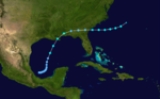
The 1923 Atlantic hurricane season ran its course from
Summer through Fall of 1923. The season was slightly below average with 9 tropical storms; of which 4 became hurricanes, and one became a major hurricane.
. The storm crossed the United State until moving offshore in Georgia. After that the storm dissipated on June 28.
turned north and then northeast, very close to Bermuda
, before becoming a hurricane. After passing Bermuda and reaching hurricane strength, the storm turned north and slowed down. For two days, the storm drifted slowly northward across the Atlantic, reaching a peak intensity of 105 mi/h. On September 8, the storm weakened to a Category 1 hurricane and began to accelerate while curving slightly to the northeast. The storm became extratropical
shortly before striking Newfoundland, on the evening of September 9. No damage was reported.
on September 24. It passed through the Bahamas
as a strengthening hurricane, and recurved northeast as it approached the southeastern United States
. The storm began to weaken as it entered the cooler waters of the north Atlantic, finally dissolving into a powerful extratropical cyclone
affecting Newfoundland with hurricane-force winds. Damage, however, was minimal in all affected areas.
in mid-October. The storm struck the Mexican state of Oaxaca
on October 13, crossing the Isthmus of Tehuantepec
into the Bay of Campeche
. It strengthened into a hurricane while continuing northward across the Gulf of Mexico
, making landfall along Atchafalaya Bay, Louisiana
as a Category 2. Damage was restricted to harbor areas, including sunken barges or barges driven ashore. There were reports of downed trees and telegraph poles.
on October 15, and moved northeast for its first two days before recurving back to the northwest. The storm never strengthened much and struck Cape Cod
as a weakening tropical storm. The highest wind gust reported was 48 mi/h on Nantucket.
coast with 45 mi/h sustained winds. The strongest gust reported was 56 mi/h at Pensacola, Florida
.
Summer through Fall of 1923. The season was slightly below average with 9 tropical storms; of which 4 became hurricanes, and one became a major hurricane.
Tropical Storm One
Tropical Storm One formed north of Mexico in the Gulf of Mexico. It made landfall in LouisianaLouisiana
Louisiana is a state located in the southern region of the United States of America. Its capital is Baton Rouge and largest city is New Orleans. Louisiana is the only state in the U.S. with political subdivisions termed parishes, which are local governments equivalent to counties...
. The storm crossed the United State until moving offshore in Georgia. After that the storm dissipated on June 28.
Hurricane Two
The season began late with a tropical storm observed northeast of Turks and Caicos on August 30. The cycloneCyclone
In meteorology, a cyclone is an area of closed, circular fluid motion rotating in the same direction as the Earth. This is usually characterized by inward spiraling winds that rotate anticlockwise in the Northern Hemisphere and clockwise in the Southern Hemisphere of the Earth. Most large-scale...
turned north and then northeast, very close to Bermuda
Bermuda
Bermuda is a British overseas territory in the North Atlantic Ocean. Located off the east coast of the United States, its nearest landmass is Cape Hatteras, North Carolina, about to the west-northwest. It is about south of Halifax, Nova Scotia, Canada, and northeast of Miami, Florida...
, before becoming a hurricane. After passing Bermuda and reaching hurricane strength, the storm turned north and slowed down. For two days, the storm drifted slowly northward across the Atlantic, reaching a peak intensity of 105 mi/h. On September 8, the storm weakened to a Category 1 hurricane and began to accelerate while curving slightly to the northeast. The storm became extratropical
Extratropical cyclone
Extratropical cyclones, sometimes called mid-latitude cyclones or wave cyclones, are a group of cyclones defined as synoptic scale low pressure weather systems that occur in the middle latitudes of the Earth having neither tropical nor polar characteristics, and are connected with fronts and...
shortly before striking Newfoundland, on the evening of September 9. No damage was reported.
Tropical Storm Three
This tropical storm formed near the coast of Africa on September 7, however it was short lived and never approached land.Hurricane Four
A tropical storm formed near the coast of the US on September 10. It intesified on September 12, but that was shortlived and weakened rapidly into an extropical force, which then made landfall in Canada. Damage was minimal.Hurricane Five
Hurricane Five, the season's only major hurricane, was discovered north of HispaniolaHispaniola
Hispaniola is a major island in the Caribbean, containing the two sovereign states of the Dominican Republic and Haiti. The island is located between the islands of Cuba to the west and Puerto Rico to the east, within the hurricane belt...
on September 24. It passed through the Bahamas
The Bahamas
The Bahamas , officially the Commonwealth of the Bahamas, is a nation consisting of 29 islands, 661 cays, and 2,387 islets . It is located in the Atlantic Ocean north of Cuba and Hispaniola , northwest of the Turks and Caicos Islands, and southeast of the United States...
as a strengthening hurricane, and recurved northeast as it approached the southeastern United States
United States
The United States of America is a federal constitutional republic comprising fifty states and a federal district...
. The storm began to weaken as it entered the cooler waters of the north Atlantic, finally dissolving into a powerful extratropical cyclone
Extratropical cyclone
Extratropical cyclones, sometimes called mid-latitude cyclones or wave cyclones, are a group of cyclones defined as synoptic scale low pressure weather systems that occur in the middle latitudes of the Earth having neither tropical nor polar characteristics, and are connected with fronts and...
affecting Newfoundland with hurricane-force winds. Damage, however, was minimal in all affected areas.
Hurricane Six
The third storm of 1923 was the first recorded example of a storm crossing from the Eastern Pacific basin into the Atlantic basin. It formed in the deep tropical latitudes south of GuatemalaGuatemala
Guatemala is a country in Central America bordered by Mexico to the north and west, the Pacific Ocean to the southwest, Belize to the northeast, the Caribbean to the east, and Honduras and El Salvador to the southeast...
in mid-October. The storm struck the Mexican state of Oaxaca
Oaxaca
Oaxaca , , officially Estado Libre y Soberano de Oaxaca is one of the 31 states which, along with the Federal District, comprise the 32 federative entities of Mexico. It is divided into 571 municipalities; of which 418 are governed by the system of customs and traditions...
on October 13, crossing the Isthmus of Tehuantepec
Isthmus of Tehuantepec
The Isthmus of Tehuantepec is an isthmus in Mexico. It represents the shortest distance between the Gulf of Mexico and the Pacific Ocean, and prior to the opening of the Panama Canal was a major shipping route known simply as the Tehuantepec Route...
into the Bay of Campeche
Bay of Campeche
The Bay of Campeche is the southern bight of the Gulf of Mexico. It is surrounded on three sides by the Mexican states of Campeche, Tabasco and Veracruz. It was named by Francisco Hernández de Córdoba and Antonio de Alaminos during their expedition in 1517...
. It strengthened into a hurricane while continuing northward across the Gulf of Mexico
Gulf of Mexico
The Gulf of Mexico is a partially landlocked ocean basin largely surrounded by the North American continent and the island of Cuba. It is bounded on the northeast, north and northwest by the Gulf Coast of the United States, on the southwest and south by Mexico, and on the southeast by Cuba. In...
, making landfall along Atchafalaya Bay, Louisiana
Louisiana
Louisiana is a state located in the southern region of the United States of America. Its capital is Baton Rouge and largest city is New Orleans. Louisiana is the only state in the U.S. with political subdivisions termed parishes, which are local governments equivalent to counties...
as a Category 2. Damage was restricted to harbor areas, including sunken barges or barges driven ashore. There were reports of downed trees and telegraph poles.
Tropical Storm Seven
Storm number five formed north of the Leeward IslandsLeeward Islands
The Leeward Islands are a group of islands in the West Indies. They are the northern islands of the Lesser Antilles chain. As a group they start east of Puerto Rico and reach southward to Dominica. They are situated where the northeastern Caribbean Sea meets the western Atlantic Ocean...
on October 15, and moved northeast for its first two days before recurving back to the northwest. The storm never strengthened much and struck Cape Cod
Cape Cod
Cape Cod, often referred to locally as simply the Cape, is a cape in the easternmost portion of the state of Massachusetts, in the Northeastern United States...
as a weakening tropical storm. The highest wind gust reported was 48 mi/h on Nantucket.
Tropical Storm Eight
Tropical storm eight was a large but disorganized system, developing in the central Gulf of Mexico on October 16. Its formation meant, for a brief time on October 16, there were three tropical storms active in the Atlantic simultaneously, a rare occurrence. The storm moved northeast, gaining little intensity and striking the MississippiMississippi
Mississippi is a U.S. state located in the Southern United States. Jackson is the state capital and largest city. The name of the state derives from the Mississippi River, which flows along its western boundary, whose name comes from the Ojibwe word misi-ziibi...
coast with 45 mi/h sustained winds. The strongest gust reported was 56 mi/h at Pensacola, Florida
Pensacola, Florida
Pensacola is the westernmost city in the Florida Panhandle and the county seat of Escambia County, Florida, United States of America. As of the 2000 census, the city had a total population of 56,255 and as of 2009, the estimated population was 53,752...
.
Tropical Storm Nine
Storm seven was not mentioned in the Monthly Weather Review and little is known about it beyond the official track record. It formed in late October, north of the Leeward Islands, and moved northward before turning northwest. The storm never gained much intensity, and lost its identity south of Bermuda. Its extratropical remnant likely brought gusty winds to Bermuda.See also
- List of tropical cyclones
- List of Atlantic hurricane seasons