
1915 Atlantic hurricane season
Encyclopedia
The 1915 Atlantic hurricane season ran through the summer and the first half of fall in 1915.
.
in early August, turned northeast, and dissipated over New England
.
on the 10th. As the hurricane continued through the Caribbean Sea
, it passed just south of Puerto Rico
and Hispaniola
before crossing Jamaica
on August 13 where it caused heavy damage. While south of Cuba
it rapidly intensified, and it brushed the western tip of the country on August 15 as a strong Category 4 hurricane. Over the Gulf of Mexico the hurricane weakened slightly. It made landfall near Galveston, Texas
as a low-end Category 4 hurricane on August 17. It turned northward, became extratropical on August 18, and dissipated on August 23. Just fifteen years after the 1900 Galveston Hurricane
, this hurricane damaged the already hurting Texas
economy. Throughout its path, it caused a total of $50 million in damage (1915 USD, $921 million in 2005 USD) and 400 casualties.
, bringing heavy surf and moderate damage to the island. The hurricane turned to the west, north, and finally recurved out to sea, becoming extratropical on September 10.
. It headed north-northwestward, strengthening to a Category 2 hurricane as it made landfall on western Cuba
. It weakened to 90 mph (130 km/h) winds when it hit near Apalachicola, Florida
on September 4. The storm continued northward and dissipated on September 9 over southern Michigan
. Well-executed warnings kept the death toll to 0, and the hurricane only caused minor to moderate damage with high tides occurring.
, strengthening to its peak of 145 mph (230 km/h) on September 25. On September 29, it made landfall near Grand Isle
as a strong Category 3 hurricane.
A barometric reading of 951 mbar (28.11 inHg) was at the time the lowest ever measured on land in the United States
. The storm caused severe flooding and killed 275 people, a number possibly reduced to well-executed warnings. Winds tore off roofs and damaged buildings in New Orleans
, where pressure was measured at down to 28.01" and a wind speed of 98 mph. Generations in south east Louisiana would refer to it as the Great Storm of 1915. Property damage in Louisiana was estimated at $13 million (1915 USD, $239 million in 2005 USD), with $5 million of that in the city of New Orleans.
Storms
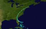
The 1915 season was not very active in terms of the number of storms but it was fairly eventful, with two powerful hurricanes hitting the Gulf Coast of the United StatesGulf Coast of the United States
The Gulf Coast of the United States, sometimes referred to as the Gulf South, South Coast, or 3rd Coast, comprises the coasts of American states that are on the Gulf of Mexico, which includes Texas, Louisiana, Mississippi, Alabama, and Florida and are known as the Gulf States...
.
Hurricane One
The first storm hit Cape CanaveralCape Canaveral
Cape Canaveral, from the Spanish Cabo Cañaveral, is a headland in Brevard County, Florida, United States, near the center of the state's Atlantic coast. Known as Cape Kennedy from 1963 to 1973, it lies east of Merritt Island, separated from it by the Banana River.It is part of a region known as the...
in early August, turned northeast, and dissipated over New England
New England
New England is a region in the northeastern corner of the United States consisting of the six states of Maine, New Hampshire, Vermont, Massachusetts, Rhode Island, and Connecticut...
.
Hurricane Two
The second storm of the year was first observed in the eastern Tropical Atlantic on August 5. It tracked westward, intensifying into a hurricane on the 9th before crossing the Lesser AntillesLesser Antilles
The Lesser Antilles are a long, partly volcanic island arc in the Western Hemisphere. Most of its islands form the eastern boundary of the Caribbean Sea with the Atlantic Ocean, with the remainder located in the southern Caribbean just north of South America...
on the 10th. As the hurricane continued through the Caribbean Sea
Caribbean Sea
The Caribbean Sea is a sea of the Atlantic Ocean located in the tropics of the Western hemisphere. It is bounded by Mexico and Central America to the west and southwest, to the north by the Greater Antilles, and to the east by the Lesser Antilles....
, it passed just south of Puerto Rico
Puerto Rico
Puerto Rico , officially the Commonwealth of Puerto Rico , is an unincorporated territory of the United States, located in the northeastern Caribbean, east of the Dominican Republic and west of both the United States Virgin Islands and the British Virgin Islands.Puerto Rico comprises an...
and Hispaniola
Hispaniola
Hispaniola is a major island in the Caribbean, containing the two sovereign states of the Dominican Republic and Haiti. The island is located between the islands of Cuba to the west and Puerto Rico to the east, within the hurricane belt...
before crossing Jamaica
Jamaica
Jamaica is an island nation of the Greater Antilles, in length, up to in width and 10,990 square kilometres in area. It is situated in the Caribbean Sea, about south of Cuba, and west of Hispaniola, the island harbouring the nation-states Haiti and the Dominican Republic...
on August 13 where it caused heavy damage. While south of Cuba
Cuba
The Republic of Cuba is an island nation in the Caribbean. The nation of Cuba consists of the main island of Cuba, the Isla de la Juventud, and several archipelagos. Havana is the largest city in Cuba and the country's capital. Santiago de Cuba is the second largest city...
it rapidly intensified, and it brushed the western tip of the country on August 15 as a strong Category 4 hurricane. Over the Gulf of Mexico the hurricane weakened slightly. It made landfall near Galveston, Texas
Galveston, Texas
Galveston is a coastal city located on Galveston Island in the U.S. state of Texas. , the city had a total population of 47,743 within an area of...
as a low-end Category 4 hurricane on August 17. It turned northward, became extratropical on August 18, and dissipated on August 23. Just fifteen years after the 1900 Galveston Hurricane
Galveston Hurricane of 1900
The Hurricane of 1900 made landfall on the city of Galveston in the U.S. state of Texas, on September 8, 1900.It had estimated winds of at landfall, making it a Category 4 storm on the Saffir-Simpson Hurricane Scale...
, this hurricane damaged the already hurting Texas
Texas
Texas is the second largest U.S. state by both area and population, and the largest state by area in the contiguous United States.The name, based on the Caddo word "Tejas" meaning "friends" or "allies", was applied by the Spanish to the Caddo themselves and to the region of their settlement in...
economy. Throughout its path, it caused a total of $50 million in damage (1915 USD, $921 million in 2005 USD) and 400 casualties.
Hurricane Three
Hurricane Three, which was first observed on August 28 in the central Tropical Atlantic, tracked northwestward to reach a peak of 120 mph winds. It stalled and drifted south near BermudaBermuda
Bermuda is a British overseas territory in the North Atlantic Ocean. Located off the east coast of the United States, its nearest landmass is Cape Hatteras, North Carolina, about to the west-northwest. It is about south of Halifax, Nova Scotia, Canada, and northeast of Miami, Florida...
, bringing heavy surf and moderate damage to the island. The hurricane turned to the west, north, and finally recurved out to sea, becoming extratropical on September 10.
Hurricane Four
On August 31, a tropical storm developed southwest of JamaicaJamaica
Jamaica is an island nation of the Greater Antilles, in length, up to in width and 10,990 square kilometres in area. It is situated in the Caribbean Sea, about south of Cuba, and west of Hispaniola, the island harbouring the nation-states Haiti and the Dominican Republic...
. It headed north-northwestward, strengthening to a Category 2 hurricane as it made landfall on western Cuba
Cuba
The Republic of Cuba is an island nation in the Caribbean. The nation of Cuba consists of the main island of Cuba, the Isla de la Juventud, and several archipelagos. Havana is the largest city in Cuba and the country's capital. Santiago de Cuba is the second largest city...
. It weakened to 90 mph (130 km/h) winds when it hit near Apalachicola, Florida
Apalachicola, Florida
Apalachicola is a city in Franklin County, Florida, on US 98 about southwest of Tallahassee. The population was 2,334 at the 2000 census. The 2005 census estimated the city's population at 2,340...
on September 4. The storm continued northward and dissipated on September 9 over southern Michigan
Michigan
Michigan is a U.S. state located in the Great Lakes Region of the United States of America. The name Michigan is the French form of the Ojibwa word mishigamaa, meaning "large water" or "large lake"....
. Well-executed warnings kept the death toll to 0, and the hurricane only caused minor to moderate damage with high tides occurring.
Hurricane Six
The sixth and final storm of the year was first seen just west of the Lesser Antilles on September 22. It tracked through the CaribbeanCaribbean
The Caribbean is a crescent-shaped group of islands more than 2,000 miles long separating the Gulf of Mexico and the Caribbean Sea, to the west and south, from the Atlantic Ocean, to the east and north...
, strengthening to its peak of 145 mph (230 km/h) on September 25. On September 29, it made landfall near Grand Isle
Grand Isle, Louisiana
Grand Isle is a town in Jefferson Parish, Louisiana, located on a barrier island of the same name in the Gulf of Mexico. The island is at the mouth of Barataria Bay where it meets the gulf. As of the 2000 census, the town population was 1,541; during summers, the population sometimes increases to...
as a strong Category 3 hurricane.
A barometric reading of 951 mbar (28.11 inHg) was at the time the lowest ever measured on land in the United States
United States
The United States of America is a federal constitutional republic comprising fifty states and a federal district...
. The storm caused severe flooding and killed 275 people, a number possibly reduced to well-executed warnings. Winds tore off roofs and damaged buildings in New Orleans
New Orleans, Louisiana
New Orleans is a major United States port and the largest city and metropolitan area in the state of Louisiana. The New Orleans metropolitan area has a population of 1,235,650 as of 2009, the 46th largest in the USA. The New Orleans – Metairie – Bogalusa combined statistical area has a population...
, where pressure was measured at down to 28.01" and a wind speed of 98 mph. Generations in south east Louisiana would refer to it as the Great Storm of 1915. Property damage in Louisiana was estimated at $13 million (1915 USD, $239 million in 2005 USD), with $5 million of that in the city of New Orleans.
See also
- List of tropical cyclones
- List of Atlantic hurricane seasons