
1900 Atlantic hurricane season
Encyclopedia
The 1900 Atlantic hurricane season ran through the summer and early fall months of 1900. The season was below average, with seven tropical storms, of which three became hurricanes, two of them major.
, Haiti
, and Cuba
. After leaving Cuba and entering the Gulf of Mexico
, it intensified rapidly into a Category 1 hurricane late on September 6 and eventually to a Category 4 hurricane
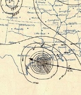
on September 8, peaking with winds of 140 mph (220 km/h) winds before making landfall near Galveston, Texas
. The hurricane was unforeseen in Galveston, resulting in the storm surge and wind damage causing an immense loss of life. After moving inland, it quickly weakened to a tropical storm and began to move northeast across the central United States through Michigan
and into New York
and through Maine
. All in all, the Galveston Hurricane of 1900 is responsible for 8,000 to 12,000 deaths, making it the deadliest natural disaster in U.S. history.
. It gathered steam as it tracked to the north-west, and became a strong Category 3 hurricane with maximum winds of 120 mph (193 km/h). Suddenly, it veered to the north and then tracked north-east away from any land, passing by Bermuda and into the north Atlantic, where it dissipated.
as a Cape Verde-type hurricane
on September 9. This one turned north, reaching Category 2 status with maximum winds of 100 mph (161 km/h), then turned east and quickly performed a complete loop as a Category 1, sending it west, away from Africa. It continued on a west-northwesterly track, until it ran into unfavorable conditions and dissipated.
, and hit at the southern tip of Alabama
and Mississippi
. It went up into Alabama, with maximum winds of 50 mph (80 km/h). It skimmed over Alabama and into Georgia
, where it died out.
. Suddenly, it turned north as a 70 mph (113 km/h) tropical storm. It continued north, where it eventually hit Nova Scotia
. It went unusually far north, past Canada
, before it dissipated.
and began moving northeast through the Gulf of Mexico
, strengthening little. The system made landfall near Lake City, Florida
on October 12 with 45 mph (75 km/h) winds and quickly became extratropical as it moved across northern Florida. The extratropical low skirted the East Coast of the United States
before making landfall on Long Island
, New York
and accelerating through New England
into eastern Canada
, where it dissipated.
on October 24. The system moved west-northwestward over Hispaniola
and gradually strengthened, becoming a tropical storm off the coast of Haiti
on October 26. The storm then recurved to the north-northeast over the Bahamas, strengthening slightly to a peak of 50 mph (85 km/h) on October 27 before becoming extratropical over the open Atlantic Ocean on October 29.
Hurricane One
A tropical storm formed in the south central Atlantic on August 27 with winds of 40 mph (65 km/h). The weak tropical storm moved west-northwest for a week through the Dominican RepublicDominican Republic
The Dominican Republic is a nation on the island of La Hispaniola, part of the Greater Antilles archipelago in the Caribbean region. The western third of the island is occupied by the nation of Haiti, making Hispaniola one of two Caribbean islands that are shared by two countries...
, Haiti
Haiti
Haiti , officially the Republic of Haiti , is a Caribbean country. It occupies the western, smaller portion of the island of Hispaniola, in the Greater Antillean archipelago, which it shares with the Dominican Republic. Ayiti was the indigenous Taíno or Amerindian name for the island...
, and Cuba
Cuba
The Republic of Cuba is an island nation in the Caribbean. The nation of Cuba consists of the main island of Cuba, the Isla de la Juventud, and several archipelagos. Havana is the largest city in Cuba and the country's capital. Santiago de Cuba is the second largest city...
. After leaving Cuba and entering the Gulf of Mexico
Gulf of Mexico
The Gulf of Mexico is a partially landlocked ocean basin largely surrounded by the North American continent and the island of Cuba. It is bounded on the northeast, north and northwest by the Gulf Coast of the United States, on the southwest and south by Mexico, and on the southeast by Cuba. In...
, it intensified rapidly into a Category 1 hurricane late on September 6 and eventually to a Category 4 hurricane
Saffir-Simpson Hurricane Scale
The Saffir–Simpson Hurricane Scale , or the Saffir–Simpson Hurricane Wind Scale , classifies hurricanes — Western Hemisphere tropical cyclones that exceed the intensities of tropical depressions and tropical storms — into five categories distinguished by the intensities of their sustained winds...
on September 8, peaking with winds of 140 mph (220 km/h) winds before making landfall near Galveston, Texas
Galveston, Texas
Galveston is a coastal city located on Galveston Island in the U.S. state of Texas. , the city had a total population of 47,743 within an area of...
. The hurricane was unforeseen in Galveston, resulting in the storm surge and wind damage causing an immense loss of life. After moving inland, it quickly weakened to a tropical storm and began to move northeast across the central United States through Michigan
Michigan
Michigan is a U.S. state located in the Great Lakes Region of the United States of America. The name Michigan is the French form of the Ojibwa word mishigamaa, meaning "large water" or "large lake"....
and into New York
New York
New York is a state in the Northeastern region of the United States. It is the nation's third most populous state. New York is bordered by New Jersey and Pennsylvania to the south, and by Connecticut, Massachusetts and Vermont to the east...
and through Maine
Maine
Maine is a state in the New England region of the northeastern United States, bordered by the Atlantic Ocean to the east and south, New Hampshire to the west, and the Canadian provinces of Quebec to the northwest and New Brunswick to the northeast. Maine is both the northernmost and easternmost...
. All in all, the Galveston Hurricane of 1900 is responsible for 8,000 to 12,000 deaths, making it the deadliest natural disaster in U.S. history.
Hurricane Two
Another storm formed unusually close in time to the previous one on September 8, to the north-east of the Lesser AntillesLesser Antilles
The Lesser Antilles are a long, partly volcanic island arc in the Western Hemisphere. Most of its islands form the eastern boundary of the Caribbean Sea with the Atlantic Ocean, with the remainder located in the southern Caribbean just north of South America...
. It gathered steam as it tracked to the north-west, and became a strong Category 3 hurricane with maximum winds of 120 mph (193 km/h). Suddenly, it veered to the north and then tracked north-east away from any land, passing by Bermuda and into the north Atlantic, where it dissipated.
Hurricane Three
The rest of the season was fairly quiet, with the next hurricane forming off AfricaAfrica
Africa is the world's second largest and second most populous continent, after Asia. At about 30.2 million km² including adjacent islands, it covers 6% of the Earth's total surface area and 20.4% of the total land area...
as a Cape Verde-type hurricane
Cape Verde-type hurricane
A Cape Verde-type hurricane is an Atlantic hurricane that develops near the Cape Verde islands, off the west coast of Africa. The average hurricane season has about two Cape Verde-type hurricanes, which are usually the largest and most intense storms of the season because they often have plenty of...
on September 9. This one turned north, reaching Category 2 status with maximum winds of 100 mph (161 km/h), then turned east and quickly performed a complete loop as a Category 1, sending it west, away from Africa. It continued on a west-northwesterly track, until it ran into unfavorable conditions and dissipated.
Tropical Storm Four
The next storm formed on September 10, directly south of Cuba. It skimmed the western-most tip of Cuba as a 40 mph (64 km/h) tropical storm, then made its way up to the United StatesUnited States
The United States of America is a federal constitutional republic comprising fifty states and a federal district...
, and hit at the southern tip of Alabama
Alabama
Alabama is a state located in the southeastern region of the United States. It is bordered by Tennessee to the north, Georgia to the east, Florida and the Gulf of Mexico to the south, and Mississippi to the west. Alabama ranks 30th in total land area and ranks second in the size of its inland...
and Mississippi
Mississippi
Mississippi is a U.S. state located in the Southern United States. Jackson is the state capital and largest city. The name of the state derives from the Mississippi River, which flows along its western boundary, whose name comes from the Ojibwe word misi-ziibi...
. It went up into Alabama, with maximum winds of 50 mph (80 km/h). It skimmed over Alabama and into Georgia
Georgia (U.S. state)
Georgia is a state located in the southeastern United States. It was established in 1732, the last of the original Thirteen Colonies. The state is named after King George II of Great Britain. Georgia was the fourth state to ratify the United States Constitution, on January 2, 1788...
, where it died out.
Tropical Storm Five
The next storm formed in about the same area as the last one on October 4, and went north-east as well. It then veered west, looking as if would hit the east coast of FloridaFlorida
Florida is a state in the southeastern United States, located on the nation's Atlantic and Gulf coasts. It is bordered to the west by the Gulf of Mexico, to the north by Alabama and Georgia and to the east by the Atlantic Ocean. With a population of 18,801,310 as measured by the 2010 census, it...
. Suddenly, it turned north as a 70 mph (113 km/h) tropical storm. It continued north, where it eventually hit Nova Scotia
Nova Scotia
Nova Scotia is one of Canada's three Maritime provinces and is the most populous province in Atlantic Canada. The name of the province is Latin for "New Scotland," but "Nova Scotia" is the recognized, English-language name of the province. The provincial capital is Halifax. Nova Scotia is the...
. It went unusually far north, past Canada
Canada
Canada is a North American country consisting of ten provinces and three territories. Located in the northern part of the continent, it extends from the Atlantic Ocean in the east to the Pacific Ocean in the west, and northward into the Arctic Ocean...
, before it dissipated.
Tropical Storm Six
On October 10, a tropical storm developed west of the Yucatán PeninsulaYucatán Peninsula
The Yucatán Peninsula, in southeastern Mexico, separates the Caribbean Sea from the Gulf of Mexico, with the northern coastline on the Yucatán Channel...
and began moving northeast through the Gulf of Mexico
Gulf of Mexico
The Gulf of Mexico is a partially landlocked ocean basin largely surrounded by the North American continent and the island of Cuba. It is bounded on the northeast, north and northwest by the Gulf Coast of the United States, on the southwest and south by Mexico, and on the southeast by Cuba. In...
, strengthening little. The system made landfall near Lake City, Florida
Lake City, Florida
Lake City is the county seat of Columbia County, Florida, in the United States. In 2009, the U.S. Census Bureau estimated the city's population at 12,614. In addition, it is the Principal City of the Lake City Micropolitan Statistical Area, which is composed of Columbia County, and had an...
on October 12 with 45 mph (75 km/h) winds and quickly became extratropical as it moved across northern Florida. The extratropical low skirted the East Coast of the United States
East Coast of the United States
The East Coast of the United States, also known as the Eastern Seaboard, refers to the easternmost coastal states in the United States, which touch the Atlantic Ocean and stretch up to Canada. The term includes the U.S...
before making landfall on Long Island
Long Island
Long Island is an island located in the southeast part of the U.S. state of New York, just east of Manhattan. Stretching northeast into the Atlantic Ocean, Long Island contains four counties, two of which are boroughs of New York City , and two of which are mainly suburban...
, New York
New York
New York is a state in the Northeastern region of the United States. It is the nation's third most populous state. New York is bordered by New Jersey and Pennsylvania to the south, and by Connecticut, Massachusetts and Vermont to the east...
and accelerating through New England
New England
New England is a region in the northeastern corner of the United States consisting of the six states of Maine, New Hampshire, Vermont, Massachusetts, Rhode Island, and Connecticut...
into eastern Canada
Canada
Canada is a North American country consisting of ten provinces and three territories. Located in the northern part of the continent, it extends from the Atlantic Ocean in the east to the Pacific Ocean in the west, and northward into the Arctic Ocean...
, where it dissipated.
Tropical Storm Seven
A tropical depression was first observed southeast of Puerto RicoPuerto Rico
Puerto Rico , officially the Commonwealth of Puerto Rico , is an unincorporated territory of the United States, located in the northeastern Caribbean, east of the Dominican Republic and west of both the United States Virgin Islands and the British Virgin Islands.Puerto Rico comprises an...
on October 24. The system moved west-northwestward over Hispaniola
Hispaniola
Hispaniola is a major island in the Caribbean, containing the two sovereign states of the Dominican Republic and Haiti. The island is located between the islands of Cuba to the west and Puerto Rico to the east, within the hurricane belt...
and gradually strengthened, becoming a tropical storm off the coast of Haiti
Haiti
Haiti , officially the Republic of Haiti , is a Caribbean country. It occupies the western, smaller portion of the island of Hispaniola, in the Greater Antillean archipelago, which it shares with the Dominican Republic. Ayiti was the indigenous Taíno or Amerindian name for the island...
on October 26. The storm then recurved to the north-northeast over the Bahamas, strengthening slightly to a peak of 50 mph (85 km/h) on October 27 before becoming extratropical over the open Atlantic Ocean on October 29.
See also
- List of tropical cyclones
- List of Atlantic hurricane seasons