
Zillertal Alps
Encyclopedia
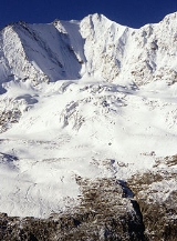
The Zillertal Alps are a mountain range of the Central Eastern Alps
on the border of Austria
and Italy
. The range is named after the Zillertal
(Ziller river valley) on its north.
The range is bounded by the Tuxerjoch mountain pass
to the north (separating it from the Tux Alps
); the Birnlücke
- Forcella del Picco pass to the east (separating it from the Hohe Tauern
); the Eisack
and its tributary the Rienz to the south (separating it from the Southern Limestone Alps
); and the Brenner Pass
to the west (separating it from the Stubai Alps
).
es of the Zillertal Alps are:
Central Eastern Alps
The Central Eastern Alps comprise the main chain of the Eastern Alps with its highest peaks, located between the Northern Limestone Alps and the Southern Limestone Alps, from which they differ in geological composition....
on the border of Austria
Austria
Austria , officially the Republic of Austria , is a landlocked country of roughly 8.4 million people in Central Europe. It is bordered by the Czech Republic and Germany to the north, Slovakia and Hungary to the east, Slovenia and Italy to the south, and Switzerland and Liechtenstein to the...
and Italy
Italy
Italy , officially the Italian Republic languages]] under the European Charter for Regional or Minority Languages. In each of these, Italy's official name is as follows:;;;;;;;;), is a unitary parliamentary republic in South-Central Europe. To the north it borders France, Switzerland, Austria and...
. The range is named after the Zillertal
Zillertal
The Zillertal is the biggest valley branching off the Inn valley in Tyrol, Austria drained by the river Ziller. It is surrounded by the strongly glaciated Zillertal Alps to the south and east, the lower grass peaks of the Kitzbühel Alps to the east and Tux Alps to the west...
(Ziller river valley) on its north.
The range is bounded by the Tuxerjoch mountain pass
Mountain pass
A mountain pass is a route through a mountain range or over a ridge. If following the lowest possible route, a pass is locally the highest point on that route...
to the north (separating it from the Tux Alps
Tux Alps
The Tux Alps or Tux Prealps are a sub-group of the Austrian Central Alps, which in turn form part of the Eastern Alps within Central Europe. They are located entirely within the Austrian federal state of Tyrol. The Tux Alps are one of three mountain ranges that form an Alpine backdrop to the city...
); the Birnlücke
Birnlücke
The Birnlücke is the border pass at the western end of the Hohe Tauern mountains in Austria, between the Venediger Group and the adjoining Zillertal Alps. The border between Austria and Italy has run over the pass since 1919...
- Forcella del Picco pass to the east (separating it from the Hohe Tauern
Hohe Tauern
The Hohe Tauern or High Tauern are a mountain range on the main chain of the Central Eastern Alps, comprising the highest peaks east of the Brenner Pass. The crest forms the southern border of the Austrian state of Salzburg with Carinthia and East Tyrol, while a small part in the southwest belongs...
); the Eisack
Eisack
The Eisack is a river in Northern Italy, the second largest river in South Tyrol. Its source is near the Brenner Pass, at an altitude of about 1990 m above sea level. The river draws water from an area of about 4,200 km². After about 96 km, it joins the Adige river south of Bolzano. At first the...
and its tributary the Rienz to the south (separating it from the Southern Limestone Alps
Southern Limestone Alps
The Southern Limestone Alps are the ranges of the Eastern Alps south of the Central Eastern Alps mainly located in northern Italy and the adjacent lands of Austria and Slovenia. The distinction from the Central Alps, where the higher peaks are located, is based on differences in geological...
); and the Brenner Pass
Brenner Pass
- Roadways :The motorway E45 leading from Innsbruck via Bolzano to Verona and Modena uses this pass, and is one of the most important north-south connections in Europe...
to the west (separating it from the Stubai Alps
Stubai Alps
The Stubai Alps is a mountain range in the Central Eastern Alps of Europe. It is named after the Stubaital valley to its east. It is located southwest of Innsbruck, Austria, and several summits of the range form part of Austria's border with Italy...
).
Peaks
The main peaks of the Zillertal Alps are:| Peak | |Elevation (m/ft) | |
|---|---|---|
| Hochfeiler Hochfeiler The Hochfeiler is a mountain in the Zillertal Alps on the border between Tyrol, Austria, and South Tyrol, Italy.- References :* Heinrich Klier, Walter Klier: Alpenvereinsführer Zillertaler Alpen, Rother Verlag München , ISBN 3-7633-1269-2... |
3510 | 11,515 |
| Großer Möseler | 3486 | 11,438 |
| Olperer Olperer The Olperer is a 3,476 metre high mountain in the Zillertal Alps in the Austrian federal state of Tyrol. It is the main summit on the Tux Crest and is often crossed in the summer as climbers transit from the Olperer Hut to the Geraer Hut. It was first climbed on 10 September 1867 along the... |
3480 | 11,418 |
| Turnerkamp Turnerkamp The Turnerkamp is a mountain in the Zillertal Alps on the border between Tyrol, Austria, and South Tyrol, Italy.- References :* H. Klier, Walter Klier: Alpenvereinsführer Zillertaler Alpen. Rother Verlag, München 1996, ISBN 3-7633-1269-2... |
3422 | 11,228 |
| Großer Löffler Großer Löffler The Großer Löffler is a mountain in the Zillertal Alps on the border between Tyrol, Austria, and South Tyrol, Italy.- References :* Heinrich Klier, Walter Klier: Alpenvereinsführer Zillertaler Alpen, Rother Verlag München , ISBN 3-7633-1269-2... |
3382 | 11,096 |
| Fußstein | 3380 | 11,090 |
| Schwarzenstein | 3370 | 11,057 |
| Reichenspitze | 3305 | 10,844 |
| Großer Mörchner | 3287 | 10,785 |
| Zsigmondyspitze | 3085 | 10,122 |
Passes
The main mountain passMountain pass
A mountain pass is a route through a mountain range or over a ridge. If following the lowest possible route, a pass is locally the highest point on that route...
es of the Zillertal Alps are:
| Mountain pass | Location | Type | Elevation (m/ft) | |
|---|---|---|---|---|
| Mitterbachjoch | Zemmtal to Sand in Taufers Sand in Taufers Sand in Taufers is a comune in South Tyrol in the Italian region Trentino-Alto Adige/Südtirol, located about 110 km northeast of the city of Trento and about 70 km northeast of the city of Bolzano, on the border with Austria.... |
snow | 3130 | 10,270 |
| Trippachsattel | Floiten Valley to Sand in Taufers | snow | 3054 | 10,020 |
| Alpeinerscharte | Zemmtal to Wipptal Wipptal The Wipptal is a valley extending along the Sill River southward from Innsbruck, Tyrol, Austria, where the Sill meets the larger Inn river, up to the Brenner Pass at the Austro-Italian border, one of the lowest passes across the Central Eastern Alps... |
foot path | 2960 | 9712 |
| Keilbachjoch | Mayrhofen Mayrhofen - Twin towns : Chur, Switzerland Bad Tölz, Germany Bad Homburg, Germany Terracina, Italy Cabourg, France Bad Mondorf, Luxembourg- Transport :Mayrhofen has one railway station, which is located next to the Zillertaler Bundestrasse. The station is a terminus for all Train services operated by the... to Ahrntal Ahrntal Ahrntal is a Gemeinde and valley in South Tyrol in the northern Italian region Trentino-Alto Adige/Südtirol.-Geography:The municipality lies about 120 km northeast of the city of Trento and about 70 km northeast of the city of Bolzano, on the border with Austria... |
foot path | 2868 | 9410 |
| Heiliggeistjöchl | Mayrhofen to Ahrntal | foot path | 2658 | 8721 |
| Krimmlertauern | Krimml to Ahrntal | foot path | 2634 | 8642 |
| Horndljöchl | Mayrhofen to Ahrntal | foot path | 2555 | 8383 |
| Lappacherjoch | Lappach Lappach Lappach is a river of Bavaria, Germany.-See also:*List of rivers of Bavaria... to Ahrntal |
foot path | 2366 | 7763 |
| Tuxerjoch | Tuxertal to Wipptal | foot path | 2346 | 7697 |
| Pfitscherjoch Pfitscherjoch The Pfitscherjoch is a mountain pass in the Zillertal Alps on the border between Tyrol, Austria, and South Tyrol, Italy.-See also:* List of highest paved roads in Europe* List of mountain passes- References :* *... |
Zemmtal to Sterzing Sterzing Sterzing is a comune in South Tyrol in the region of Trentino-Alto Adige/Südtirol, Italy. It is the main village of the southern Wipptal, and the Eisack River flows through the medieval town.-Origin:... |
foot path | 2248 | 7376 |