

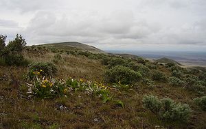
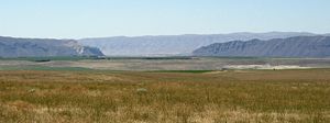
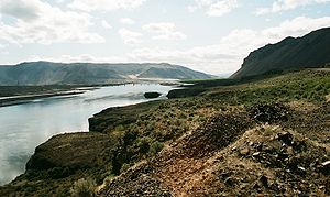
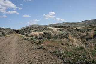
Saddle Mountains
Encyclopedia
Anticline
In structural geology, an anticline is a fold that is convex up and has its oldest beds at its core. The term is not to be confused with antiform, which is a purely descriptive term for any fold that is convex up. Therefore if age relationships In structural geology, an anticline is a fold that is...
ridge of basalt
Basalt
Basalt is a common extrusive volcanic rock. It is usually grey to black and fine-grained due to rapid cooling of lava at the surface of a planet. It may be porphyritic containing larger crystals in a fine matrix, or vesicular, or frothy scoria. Unweathered basalt is black or grey...
in Grant County of central Washington state. The ridge, reaching to 2,700 feet, terminates in the east south of Othello, Washington
Othello, Washington
Othello is a city in Adams County, Washington, United States. The population was 5,847 at the 2000 census and grew 25.9% over the next decade to 7,364 at the 2010 census. Othello refers to the city as being in the "Heart" of the Columbia Basin Project...
near the foot of the Drumheller Channels. It continues to the west where it is broken at Sentinel Gap (a water gap through which the Columbia River
Columbia River
The Columbia River is the largest river in the Pacific Northwest region of North America. The river rises in the Rocky Mountains of British Columbia, Canada, flows northwest and then south into the U.S. state of Washington, then turns west to form most of the border between Washington and the state...
passes) before ending in the foothills of the Cascade Mountains.
Saddle Mountains Geology
The top exposed layer of Columbia River Basalt GroupColumbia River Basalt Group
The Columbia River Basalt Group is a large igneous province that lies across parts of the Western United States. It is found in the U.S. states of Washington, Oregon, Idaho, Nevada, and California...
basalt in the Saddle Mountains is the Saddle Mountain Basalt, which ranges from 120 – 240 meters (400 – 800 feet) in thickness and is interspersed by sedimentary layers of the Ellensburg Formation. The Saddle Mountain Basalt is composed of the Umatilla Member flows, the Wilbur Creek Member flows, the Asotin Member flows (13 million years ago), the Weissenfels Ridge Member flows, the Esquatzel Member flows, the Elephant Mountain Member flows (10.5 million years ago), the Bujford Member flows, the Ice Harbor Member flows (8.5 million years ago) and the Lower Monumental Member flows (6 million years ago).
The Cordilleran Glacier
Cordilleran Ice Sheet
The Cordilleran ice sheet was a major ice sheet that covered, during glacial periods of the Quaternary, a large area of North America. This included the following areas:*Western Montana*The Idaho Panhandle...
diverted the ancient route of the Columbia River
Columbia River
The Columbia River is the largest river in the Pacific Northwest region of North America. The river rises in the Rocky Mountains of British Columbia, Canada, flows northwest and then south into the U.S. state of Washington, then turns west to form most of the border between Washington and the state...
15,000 years ago, backing up water to create Lake Spokane. As the Okanogan lobe grew the Columbia was rerouted into the Grand Coulee
Grand Coulee
The Grand Coulee is an ancient river bed in the U.S. state of Washington. This National Natural Landmark stretches for about sixty miles southwest from Grand Coulee Dam to Soap Lake, being bisected by Dry Falls into the Upper and Lower Grand Coulee....
. Flowing across the current Grand Coulee-Dry Falls
Dry Falls
Dry Falls is a 3.5 mile long scalloped precipice in central Washington, on the opposite side of the Upper Grand Coulee from the Columbia River, and at the head of the Lower Grand Coulee. Ten times the size of Niagara, Dry Falls is thought to be the greatest known waterfall that ever existed...
region, the ice-age Columbia then entered the Quincy Basin near Quincy, Washington
Quincy, Washington
Quincy Washington Quincy is a city in Grant County, Washington, United States. The population was 6,750 at the 2010 census.-History:...
& joined Crab Creek
Crab Creek
Crab Creek is a stream in the U.S. state of Washington. Named for the presence of crayfish, it is one of the few perennial streams in the Columbia Basin of central Washington, flowing from the northeastern Columbia River Plateau, roughly east of Reardan, west-southwest to empty into the Columbia...
at Moses Lake, following Crab Creek’s course southward past the Frenchman Hills and turning west to run along the north face of the Saddle Mountains, there to rejoin the previous and modern course of the Columbia River just above the main water gap in the Saddle Mountains, Sentinel Gap. It eroded the north face of the Saddle Mountains, creating the conditions for the Corfu Slide
Corfu Slide
The Corfu Slide is a geological feature located on the north slope of the Saddle Mountains above Crab Creek near the Columbia river in eastern Washington...
.
Geography
| Location | Coordinates |
|---|---|
| Eastern portion of Saddle Mountains where Lower Crab Creek meets the Corfu Slide Corfu Slide The Corfu Slide is a geological feature located on the north slope of the Saddle Mountains above Crab Creek near the Columbia river in eastern Washington... |
46°49′00"N 119°22′30"W |
| Red Rock Coulee area | 46°49′20"N 119°35′00"W |
| Sentinal Gap through which the Columbia River passes | 46°49′00"N 119°54′00"W |
| Corfu Slide region of Saddle Mountains | 46°47′52"N 119°35′00"W |
See also
- Corfu SlideCorfu SlideThe Corfu Slide is a geological feature located on the north slope of the Saddle Mountains above Crab Creek near the Columbia river in eastern Washington...
- Saddle Mountain National Wildlife Refuge