
Wonsan
Encyclopedia
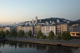
Wŏnsan is a port city and naval base in southeastern North Korea
. It is the capital of Kangwŏn Province. The population of the city is estimated to have been 331,000 in 2000. Notable people from Wŏnsan include Kim Ki Nam
, diplomat and Secretary of the Workers' Party
.
it was known as Port Lazarev (Lazaref). In 1914 the Pyongwon Line
and Gyeongwon Line
railways were opened, connecting the city to Pyongyang
and Seoul
(then known as Kyongsong). Thus, the city gradually developed into the eastern product distribution center. Under the Japanese occupation, the city was heavily industrialized and served as an import point in the distribution of trade between Korea and mainland Japan.
into a zone under Soviet control in the north and one of American control in the south in 1945) and became its capital, as Kangwŏn's traditional capitals Wonju
(1395–1895) and Chuncheon
(since 1896) both were south of the 38th parallel and south of the Military Demarcation Line
that replaced the 38th parallel as a border in 1953. It was heavily bombed by the United Nations
during the Korean War
: Blockade of Wonsan. In fact, according to the official US Navy history, Wŏnsan was under continuous siege and bombardment by the American navy from March 1951 until July 27, 1953, making it the longest siege in modern American naval history. By war's end the city was a vast shell.
Wŏnsan serves as the administrative center of Kangwŏn Province.
(East Sea of Korea) and the east end of the Korean peninsula's neck. Mt. Changdok (Changdok-san) and Mt. Naphal (Naphal-san) are located to the west of the city. More than 20 small islands flank Wŏnsan's immediate coastal area, including Hwangt'o Island and Ryo Island. Wŏnsan is considered an excellent natural port location.Kŭmgang-san mountain is located near Wŏnsan.
The city has a borderline humid subtropical climate
(Köppen
Cwa) that is very close to a humid continental climate
(Dwa).
Wonsan Station
is on the highway system and the Kangwon Line
electric railway, with connections to Pyongyang
and other North Korean cities.
Air
The city has a military and civilian dual purposes air station (WON) and is equipped with 01/19 and 15/33 dual runways.
Sea
Wonsan is also the terminus of the Mangyongbong-92
ferry
, the only direct connection between Japan
and North Korea.
transmitter broadcasting on 882 kHz AM.
, a football (soccer)
club that plays in the DPR Korea First Class Sports Group
, North Korea's premier league.
Songdowon International Children's Union Camp was built beside Songdowon, at 39°11′14"N 127°24′28"E, and it still receives teenagers and youth for cultural exchange between North Korea and various foreign countries.
Famous scenic sites near Wŏnsan: Myongsasimni, Lake Sijung, Chongsokjon and Mt. Kumgang
. Temples in the area include the Sogwangsa
and Anbyon Pohyonsa Buddhist temples.
North Korea
The Democratic People’s Republic of Korea , , is a country in East Asia, occupying the northern half of the Korean Peninsula. Its capital and largest city is Pyongyang. The Korean Demilitarized Zone serves as the buffer zone between North Korea and South Korea...
. It is the capital of Kangwŏn Province. The population of the city is estimated to have been 331,000 in 2000. Notable people from Wŏnsan include Kim Ki Nam
Kim Ki Nam
Kim Ki-nam is a North Korean official. He is vice-chairman of the Committee for Peaceful Reunification of the Fatherland, in which capacity he has led numerous visits to the South. He is also Secretary of the Workers' Party of Korea, and has served several terms in the Supreme People's Assembly,...
, diplomat and Secretary of the Workers' Party
Workers' Party of Korea
The Workers' Party of Korea is the ruling Communist party of the Democratic People's Republic of Korea , commonly known as North Korea. It is also called the Korean Workers' Party...
.
History
The original name of Wonsan was Wŏnsanjin (元山津). It opened as trade port in 1880. In the late 19th century19th century
The 19th century was a period in history marked by the collapse of the Spanish, Portuguese, Chinese, Holy Roman and Mughal empires...
it was known as Port Lazarev (Lazaref). In 1914 the Pyongwon Line
Pyongwon Line
The Pyongwon Line was a railway line in Korea, opened in 1914 during the period of Japanese rule. The line connected Pyongyang to Wonsan. It is wholly in what is now North Korea and forms part of these present day lines:* Pyongyang to Pyongsan, Pyongbu Line...
and Gyeongwon Line
Gyeongwon Line
The Gyeongwon Line is a railway line serving northeastern Gyeonggi Province in South Korea. The line is operated by Korail. The name of the line came from Gyeongseong and Wonsan, the original terminus of the line in what is now North Korea.-History:The Gyeongwon line was opened along its full...
railways were opened, connecting the city to Pyongyang
Pyongyang
Pyongyang is the capital of the Democratic People's Republic of Korea, commonly known as North Korea, and the largest city in the country. Pyongyang is located on the Taedong River and, according to preliminary results from the 2008 population census, has a population of 3,255,388. The city was...
and Seoul
Seoul
Seoul , officially the Seoul Special City, is the capital and largest metropolis of South Korea. A megacity with a population of over 10 million, it is the largest city proper in the OECD developed world...
(then known as Kyongsong). Thus, the city gradually developed into the eastern product distribution center. Under the Japanese occupation, the city was heavily industrialized and served as an import point in the distribution of trade between Korea and mainland Japan.
Provincial borders
Wŏnsan used to be in South Hamgyong, but when provincial borders were redrawn in 1946, it joined the northern half of Kangwŏn (which had been split at the 38th parallel north38th parallel north
The 38th parallel north is a circle of latitude that is 38 degrees north of the Earth's equatorial plane. It crosses Europe, the Mediterranean Sea, Asia, the Pacific Ocean, North America, and the Atlantic Ocean...
into a zone under Soviet control in the north and one of American control in the south in 1945) and became its capital, as Kangwŏn's traditional capitals Wonju
Wonju
Wonju is the most populous city in Gangwon province, South Korea.Wonju is a city approximately east of Seoul and the capital can be reached within 1hr 30minutes by bus or train. Wonju is home to three major universities which attract many students from Seoul and elsewhere. They provide facilities...
(1395–1895) and Chuncheon
Chuncheon
Chuncheon is the capital of Gangwon Province, South Korea. The city lies in the northeast of the country, located in a basin formed by the Soyang River and Han River. There are some large lakes around the city, most notably Lake Soyang and Lake Uiam...
(since 1896) both were south of the 38th parallel and south of the Military Demarcation Line
Military Demarcation Line (Korea)
The Military Demarcation Line , sometimes referred to as the Armistice Line, is the land border or demarcation line between North Korea and South Korea. On either side of the line is the Korean Demilitarized Zone...
that replaced the 38th parallel as a border in 1953. It was heavily bombed by the United Nations
United Nations
The United Nations is an international organization whose stated aims are facilitating cooperation in international law, international security, economic development, social progress, human rights, and achievement of world peace...
during the Korean War
Korean War
The Korean War was a conventional war between South Korea, supported by the United Nations, and North Korea, supported by the People's Republic of China , with military material aid from the Soviet Union...
: Blockade of Wonsan. In fact, according to the official US Navy history, Wŏnsan was under continuous siege and bombardment by the American navy from March 1951 until July 27, 1953, making it the longest siege in modern American naval history. By war's end the city was a vast shell.
Wŏnsan serves as the administrative center of Kangwŏn Province.
Geography and climate
Wŏnsan's area is 269 square kilometres (103.9 sq mi). It is located in Kangwŏn Province, on the westernmost part of the Sea of JapanSea of Japan
The Sea of Japan is a marginal sea of the western Pacific Ocean, between the Asian mainland, the Japanese archipelago and Sakhalin. It is bordered by Japan, North Korea, Russia and South Korea. Like the Mediterranean Sea, it has almost no tides due to its nearly complete enclosure from the Pacific...
(East Sea of Korea) and the east end of the Korean peninsula's neck. Mt. Changdok (Changdok-san) and Mt. Naphal (Naphal-san) are located to the west of the city. More than 20 small islands flank Wŏnsan's immediate coastal area, including Hwangt'o Island and Ryo Island. Wŏnsan is considered an excellent natural port location.Kŭmgang-san mountain is located near Wŏnsan.
The city has a borderline humid subtropical climate
Humid subtropical climate
A humid subtropical climate is a climate zone characterized by hot, humid summers and mild to cool winters...
(Köppen
Köppen climate classification
The Köppen climate classification is one of the most widely used climate classification systems. It was first published by Crimea German climatologist Wladimir Köppen in 1884, with several later modifications by Köppen himself, notably in 1918 and 1936...
Cwa) that is very close to a humid continental climate
Humid continental climate
A humid continental climate is a climatic region typified by large seasonal temperature differences, with warm to hot summers and cold winters....
(Dwa).
Economy
Wŏnsan has an aquatic product processing factory, shipyard, chemistry enterprise, and a cement factory.Transportation
Road and railWonsan Station
Wonsan Station
Wonsan Station is a passenger railway station located in Wonsan, North Korea. It is on Kangwon Line, formed from parts of the Gyeongwon Line which once connected Wonsan to Seoul but which is now divided by the Korean Demilitarized Zone.-First station:...
is on the highway system and the Kangwon Line
Kangwon Line
The Kangwon Line is a railway line in North Korea, running from Pyonggang to Kowon....
electric railway, with connections to Pyongyang
Pyongyang
Pyongyang is the capital of the Democratic People's Republic of Korea, commonly known as North Korea, and the largest city in the country. Pyongyang is located on the Taedong River and, according to preliminary results from the 2008 population census, has a population of 3,255,388. The city was...
and other North Korean cities.
Air
The city has a military and civilian dual purposes air station (WON) and is equipped with 01/19 and 15/33 dual runways.
Sea
Wonsan is also the terminus of the Mangyongbong-92
Mangyongbong-92
The Mangyongbong-92, named after a hill near Pyongyang, is a passenger ferry built in 1992 to celebrate the North Korean leader, Kim Il Sung's 80th birthday. The ferry was built with funds from Chongryon, the pro-Pyongyang General Association of Korean Residents in Japan.The ferry makes 20 to 30...
ferry
Ferry
A ferry is a form of transportation, usually a boat, but sometimes a ship, used to carry primarily passengers, and sometimes vehicles and cargo as well, across a body of water. Most ferries operate on regular, frequent, return services...
, the only direct connection between Japan
Japan
Japan is an island nation in East Asia. Located in the Pacific Ocean, it lies to the east of the Sea of Japan, China, North Korea, South Korea and Russia, stretching from the Sea of Okhotsk in the north to the East China Sea and Taiwan in the south...
and North Korea.
Media
The Korean Central Broadcasting Station maintains a 250-kilowatt mediumwaveMediumwave
Medium wave is the part of the medium frequency radio band used mainly for AM radio broadcasting. For Europe the MW band ranges from 526.5 kHz to 1606.5 kHz...
transmitter broadcasting on 882 kHz AM.
Education
Wŏnsan is home to Songdowon University, Kumgang University, Tonghae University, Jong Jun Thaek University of Economics, Wŏnsan University of Medicine, Jo Gun Sil University of Engineering, Wŏnsan First University of Education and Ri Su Dok University.Sports
The city is home to Woonpasan Sports GroupWoonpasan Sports Group
Woonpasan Sports Club is a North Korean football club. They play in the DPR Korea League, the highest football soccer league in North Korea....
, a football (soccer)
Football (soccer)
Association football, more commonly known as football or soccer, is a sport played between two teams of eleven players with a spherical ball...
club that plays in the DPR Korea First Class Sports Group
DPR Korea League
Highest Class Football League is the football league-system championship in North Korea. The competition was founded in 2010....
, North Korea's premier league.
Tourism
Most of North Korea, including Wonsan, is not accessible to foreign tourists. However, nearby Songdowon is a famous sea bathing destination for North Koreans, as the water there is exceptionally clear. Pine trees are abundant in the surrounding area, and it has been designated a national sightseeing point.Songdowon International Children's Union Camp was built beside Songdowon, at 39°11′14"N 127°24′28"E, and it still receives teenagers and youth for cultural exchange between North Korea and various foreign countries.
Famous scenic sites near Wŏnsan: Myongsasimni, Lake Sijung, Chongsokjon and Mt. Kumgang
Kumgangsan
Kŭmgangsan , Geumgangsan, or Mount Geumgang is a -high mountain in Kangwon-do, North Korea. Its name means "a firm heart in the face of truth". It is about 50 km away from South Korea's Sokcho in Gangwon-do. It is one of the best-known mountains in North Korea...
. Temples in the area include the Sogwangsa
Sogwangsa
Sŏgwang-sa is a Korean Buddhist temple located in Sŏlbong-ri in Kosan County, Kangwon Province, North Korea. Once one of Korea's largest Buddhist temples, the complex was mostly destroyed by US bombing in 1951, and today it lies in ruins; however, it is slated to be reconstructed in coming years...
and Anbyon Pohyonsa Buddhist temples.
Administrative divisions
Wonsan is divided into 40 administrative districts known as dong, as wells as fifteen villages ("ri"). The largest dong, Haebang, is further divided in two parts for administrative purposes.
|
(남산동/) (방하산동/) (복막동/) (봉춘동/) (봉수동/) (평화동/) (려도동/) (룡하동/) (률동/) (삼봉동/) (상동/) (신흥동/) (신풍동/) |
(신성동/) (석우동/) (송천동/) (송흥동/) (승리동/ (탑동/) (덕성동/) (동명산동/) (와우동/) (원남동/) (원석동/ (양지동/) (장림리/) (칠봉리/) |
(죽산리/) (중평리/) (춘산리/) (현동리/) (남천리/) (락수리/) (룡천리/) (삼태리/) (상자리/) (신성리/) (석현리/) (수상리/) (영삼리/) |
See also
- List of Korea-related topics
- Geography of North KoreaGeography of North KoreaNorth Korea is located in east Asia on the northern half of the Korean Peninsula. North Korea shares a border with three states, including China along the Amnok River, Russia along the Duman River, and South Korea along the Korean Demilitarized Zone...
- Naval bases of the Korean People's NavyNaval bases of the Korean People's NavyThe Korean People's Navy operates on both coastlines with major and minor bases:Overall naval HQ is in P'yongyang.-West Sea Fleet:The western fleet has approximately 300 shipsHQ , berthing facility for Yellow Sea Fleet; home to shipyard and sub base* Pip'a-got: limited operational and logistical...
External links
- North Korea Uncovered, (North Korea Google Earth) a Google Earth map of Wonsan's cultural, economic, political, military infrastructure, and tourist locations and facilities.
- The Wŏnsan Operation, October 1950 – Korean WarKorean WarThe Korean War was a conventional war between South Korea, supported by the United Nations, and North Korea, supported by the People's Republic of China , with military material aid from the Soviet Union...
amphibious assault ordered by General Douglas MacArthurDouglas MacArthurGeneral of the Army Douglas MacArthur was an American general and field marshal of the Philippine Army. He was a Chief of Staff of the United States Army during the 1930s and played a prominent role in the Pacific theater during World War II. He received the Medal of Honor for his service in the... - Google Earth images of Wŏnsan, including one of Kim Jong Il's palaces, a military airfield, and the ferry Mangyongbong-92Mangyongbong-92The Mangyongbong-92, named after a hill near Pyongyang, is a passenger ferry built in 1992 to celebrate the North Korean leader, Kim Il Sung's 80th birthday. The ferry was built with funds from Chongryon, the pro-Pyongyang General Association of Korean Residents in Japan.The ferry makes 20 to 30...
- http://nk.joins.com/map/view.asp?idx=i141.htm