

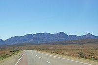
Wilpena Pound
Encyclopedia
Adelaide
Adelaide is the capital city of South Australia and the fifth-largest city in Australia. Adelaide has an estimated population of more than 1.2 million...
, South Australia
South Australia
South Australia is a state of Australia in the southern central part of the country. It covers some of the most arid parts of the continent; with a total land area of , it is the fourth largest of Australia's six states and two territories.South Australia shares borders with all of the mainland...
, Australia
Australia
Australia , officially the Commonwealth of Australia, is a country in the Southern Hemisphere comprising the mainland of the Australian continent, the island of Tasmania, and numerous smaller islands in the Indian and Pacific Oceans. It is the world's sixth-largest country by total area...
in the heart of the Flinders Ranges National Park
Flinders Ranges National Park
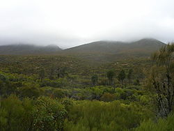
The Flinders Ranges National Park is situated approximately 400 km north of Adelaide in the northern central part of South Australia's largest mountain range, the Flinders Ranges. The park covers an area of 912 km², northeast of the small town of Hawker...
. The Pound is the most northern point with access via a sealed road in this part of the Flinders Ranges
Flinders Ranges
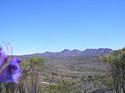
Flinders Ranges is the largest mountain range in South Australia, which starts approximately north west of Adelaide. The discontinuous ranges stretch for over from Port Pirie to Lake Callabonna...
. The closest town to the north is Blinman
Blinman, South Australia
Blinman is a town deep in the Flinders Ranges, in the mid north of South Australia. It is very small but has the claim of being the highest surveyed town in South Australia. It serves as a base for large acre pastoralists and tourism...
and to the south, Hawker
Hawker, South Australia
Hawker is a town in the Flinders Ranges area of South Australia, 365 km north of Adelaide. It is in the Flinders Ranges Council, the state Electoral district of Stuart and the federal Division of Grey. At the 2006 census, Hawker had a population of 229....
.
Attempts at farming the Pound failed during the early 20th century. Following this the tourism potential was recognised in 1945.
Geomorphology
Adelaide Geosyncline
The Adelaide Geosyncline is a major geological province in central South Australia. It stretches from the northernmost parts of the Flinders Ranges, narrowing at the Fleurieu Peninsula and extending into Kangaroo Island, and composes the two major mountain ranges of the State: the Flinders Ranges...
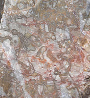
. Despite early amateur theories that it was some kind of ancient volcano, the actual Pound is sedimentary rock in the form of a large syncline
Syncline
In structural geology, a syncline is a fold, with younger layers closer to the center of the structure. A synclinorium is a large syncline with superimposed smaller folds. Synclines are typically a downward fold, termed a synformal syncline In structural geology, a syncline is a fold, with younger...
, with the fold axis running NNW-SSE through Edeowie Gorge at the northern end and Rawnsley's Bluff at the southern. A corresponding anticline
Anticline
In structural geology, an anticline is a fold that is convex up and has its oldest beds at its core. The term is not to be confused with antiform, which is a purely descriptive term for any fold that is convex up. Therefore if age relationships In structural geology, an anticline is a fold that is...
is located in the adjacent Moralana Gorge, with the Elder Range on the downturned western limb. The area has given its name to the Wilpena Group of sedimentary rocks making up the younger sediments of the geosyncline, and names of further subdivisions also originate from the area: particularly the Pound Subgroup, made up of Rawnsley Quartzite
Quartzite
Quartzite is a hard metamorphic rock which was originally sandstone. Sandstone is converted into quartzite through heating and pressure usually related to tectonic compression within orogenic belts. Pure quartzite is usually white to gray, though quartzites often occur in various shades of pink...
and Bonney Sandstone
Sandstone
Sandstone is a sedimentary rock composed mainly of sand-sized minerals or rock grains.Most sandstone is composed of quartz and/or feldspar because these are the most common minerals in the Earth's crust. Like sand, sandstone may be any colour, but the most common colours are tan, brown, yellow,...
.
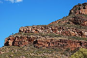
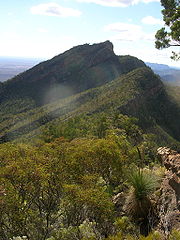
Although from the outside the Pound appears as a single range of mountains, it is actually two: one on the western edge, and one on the eastern, joined by the long Rawnsley's Bluff at the south. A gorge called Wilpena Gap has been cut in the eastern range, and most of the inside of the Pound drains into Wilpena Creek which exits through the Gap. A small part of the high northern slopes of the Pound drains into Edeowie Creek, which drains in time of flood over steep cliffs and waterfalls in Edeowie Gorge to the north.
The highest peak in the Pound, also the highest of the Flinders Ranges
Flinders Ranges
Flinders Ranges is the largest mountain range in South Australia, which starts approximately north west of Adelaide. The discontinuous ranges stretch for over from Port Pirie to Lake Callabonna...
, is St Mary Peak
St Mary Peak
St Mary Peak , is situated on the northwestern side of Wilpena Pound, and is the highest peak in the Flinders Ranges, South Australia. It lies within the Flinders Ranges National Park. St Mary Peak is the eighth highest peak in South Australia...
(1170m), on the north-eastern side. To the south of the Gap on the eastern side, the highest peak is Point Bonney (1133m). On the north-western side of the Pound, the highest point is Pompey's Pillar (1165m), and Rawnsley's Bluff (950m) at the southern end is the other major summit.
The wall of mountains almost completely encircles the gently-sloping interior of the Pound, with the only breaks being the gorge at Wilpena Gap and a high saddle in the south-western range over which the Heysen Trail
Heysen Trail
The Heysen Trail is a long distance walking trail in South Australia. It runs from Parachilna Gorge, in the Flinders Ranges via the Adelaide Hills to Cape Jervis on the Fleurieu Peninsula and is approximately 1200 km in length....
passes. This latter saddle is called Bridle Gap, supposedly because it's the only place other than the gorge where a skilled horseman might ride into the Pound. The interior of the Pound does not rise to a height at the northern edge, but instead simply drops off very steeply to the plain below in a series of steep gullies.
Nomenclature
Benjamin Babbage
Benjamin Herschel Babbage was an English engineer, scientist, explorer and politician, best known for his work in the colony of South Australia. He invariably signed his name "B...
naming it in 1856, but others says that the pastoralist George Marchant suggested the name while in the area in 1851, and the latter explanation is more likely.
Point Bonney was named after the Crown Commissioner of Lands Charles Bonney
Charles Bonney
Charles Bonney was a pioneer and politician in Australia.-Early life:Bonney was the youngest son of the Rev. George Bonney, a fellow of Jesus College, Cambridge, and his wife Susanna, née Knight. He was born at Sandon, near Stafford, Staffordshire, England...
, while Rawnsley's Bluff is named after the surveyor H.C. Rawnsley. The peak directly to the south of Wilpena Gap was known informally through much of the later twentieth century as Mount John, reportedly because bus drivers became so tired of tourists asking its name they dubbed it as such. However, it had been marked on a private survey in 1851 as Mount Ohlssen-Bagge, after a business partner of the surveyor's. In recent years the latter name has regained preeminence. The Adelaide Bushwalkers produced a detailed map of the Pound in 1959 in which they gave generic aboriginal names to many of the eastern peaks: Attunga Bluff ("high place"), Tanderra Saddle ("resting place"), Timburru Peak ("steep"), and Wangara Hill (a popular lookout to the north of Wilpena Gap) date from this map.
The peaks on the western range were named as part of a detailed survey for the hundred Moralana in 1895: the surveyor, William Greig Evans, named them all after his family and associates: Dorothy's Peak, Beatrice Hill, Madge's Hill, Harold's Hill are after his children, Reggie's Nob his brother, Greig's Peak himself, and Dick's Nob, Walter's Hill, and Fred's Nob are after members of his surveying party. Bimbornina Hill has recently gained some usage as a name for Dick's Nob, which overlooks Bridle Gap. The original 1851 name for Dorothy's Peak was Mount Boord, after the pioneer of Oraparinna station, but this name has not regained any usage.
Although not part of the Pound, the adjacent Elder Range (and its highest point Mount Aleck) was named by Frederick Sinnett after the very successful Adelaide businessman, Sir Thomas Elder.
History
Europe
Europe is, by convention, one of the world's seven continents. Comprising the westernmost peninsula of Eurasia, Europe is generally 'divided' from Asia to its east by the watershed divides of the Ural and Caucasus Mountains, the Ural River, the Caspian and Black Seas, and the waterways connecting...
an to see the mountains of the Pound was almost certainly Edward Eyre from the western plains on his first 1839 expedition
Eyre's 1839 expeditions
Edward John Eyre's two expeditions of 1839 to the interior of South Australia were his first expeditions as an explorer, if one discounts the two earlier trips he made down the Murray River to Adelaide, herding cattle and then sheep.-North:...
to the vicinity of Lake Torrens
Lake Torrens
Lake Torrens is a salt lake in central South Australia. It is located in the Lake Torrens National Park....
; although Robert Brown
Robert Brown (botanist)
Robert Brown was a Scottish botanist and palaeobotanist who made important contributions to botany largely through his pioneering use of the microscope...
climbed one of the highest peaks of the southern Flinders in March 1802, Wilpena would have been just over the horizon. Eyre did not investigate the ranges on his trip, though, and it's likely to have been the pastoralist C.N. Bagot (who applied for a lease in the area in 1851) or bushman William Chace (whose employers, W.J. and J.H. Browne applied in 1850) who first investigated the ranges at first hand. Bagot described the country and claimed to be the discoverer in a newspaper report in June 1851.
In an attempt to sort out the conflicting claims, Bonney and Surveyor-General Henry Freeling employed H.C. Rawnsley to go north and survey the area. In a controversially expensive trip, Rawnsley, of dubious skill and experience, only made it to the southern end of the Pound, which had been privately surveyed by Frederick Sinnett (employed by the Brownes) only a month or two earlier. On his arrival, Rawnsley found that the Bluff was already named after him by the locals, perhaps in an ironic wink at his shaky reputation (he was sacked by the Governor early the following year).
The Browne brothers eventually won the claim for Wilpena from Bagot, and the young Henry Strong Price opened and ran the 40,000-hectare station for them. By 1863 Wilpena consisted of well over 200,000 hectares, but was nearly ruined by the drought of that decade. According to one account, the Pound itself was used for keeping horses, and was such a good natural enclosure that the horses became as wild as brumbies
Brumby
A Brumby is a free-roaming feral horse in Australia. Although found in many areas around the country, the best-known brumbies are found in the Australian Alps region in south-eastern Australia. Today, most of them are found in the Northern Territory, with the second largest population in Queensland...
.
When Price died in 1889 the immediate 8,000-hectare area of the Pound was separated from the main run and leased separately. When the Hill family obtained this lease in 1901, they decided to try farming, something never before attempted so far north. Goyder's Line
Goyder's Line
Goyder's Line is a boundary line across South Australia corresponding to a rainfall boundary believed to indicate the edge of the area suitable for agriculture. North of Goyder's Line, the rainfall is not reliable enough, and the land is only suitable for grazing and not cropping. The line traces a...
had proven rather accurate with regard to agricultural expansion in the great drought of the 1880s, and Wilpena is some 140 km north of the Line. But being in the shadow of some of the highest mountains of the Flinders, rainfall in the Pound is a little higher (snow even being very rarely known on St Mary Peak) and the Hills were determined to try.
After the immense labour of constructing a road through the torturous Wilpena Gap, they built a small homestead inside the Pound, which still stands today, and cleared some open patches in the thick scrub of the interior. For several years the Hill family had moderate success growing crops inside the Pound, but in 1914 there was a major flood and the road through the gorge was destroyed. They could not bear to start all over and sold their homestead to the government. The Pound then became a forest reserve leased for grazing. In 1945 the tourist potential of the area was recognised when a "National Pleasure Resort" was proclaimed. A hotel called the Wilpena Chalet was opened on the southern side of the creek just outside the gorge, and it has been run by various private companies ever since.
The Pound also later became part of the Flinders Ranges National Park
Flinders Ranges National Park
The Flinders Ranges National Park is situated approximately 400 km north of Adelaide in the northern central part of South Australia's largest mountain range, the Flinders Ranges. The park covers an area of 912 km², northeast of the small town of Hawker...
.
Tourism
Wilpena Pound is one of the most popular sites in the Flinders RangesFlinders Ranges
Flinders Ranges is the largest mountain range in South Australia, which starts approximately north west of Adelaide. The discontinuous ranges stretch for over from Port Pirie to Lake Callabonna...
for international tourists to visit the outback
Outback
The Outback is the vast, remote, arid area of Australia, term colloquially can refer to any lands outside the main urban areas. The term "the outback" is generally used to refer to locations that are comparatively more remote than those areas named "the bush".-Overview:The outback is home to a...
because of the large development that has occurred at the Wilpena Pound Resort on the eastern side of Wilpena Pound and Rawnsley Park Station on the western side.There are many modern facilities there that makes it appealing for people who are not familiar with the semi-arid conditions. Tourists also go on scenic flights from an unsealed airstrip at Wilpena Pound resort and Rawnsley Park 30 km north east of Hawker
Hawker, South Australia
Hawker is a town in the Flinders Ranges area of South Australia, 365 km north of Adelaide. It is in the Flinders Ranges Council, the state Electoral district of Stuart and the federal Division of Grey. At the 2006 census, Hawker had a population of 229....
.
Bushwalking
The Pound is a very popular area for bushwalking, interesting to people of all levels of experience. The Pound traverses some of the most beautiful country in the Flinders Ranges. Tourists can do short few hour long walks out of the resort, visitor centre and campground not far off the main road. Semi-serious walkers can spend the best part of a day climbing up to St Mary PeakSt Mary Peak
St Mary Peak , is situated on the northwestern side of Wilpena Pound, and is the highest peak in the Flinders Ranges, South Australia. It lies within the Flinders Ranges National Park. St Mary Peak is the eighth highest peak in South Australia...
. Serious hikers may be interested in lightweight camping around the Pound in order to bag all the peaks in one trip, or a more detailed investigation of one area. A traverse of the peaks from Reggie's Nob to Mount Abrupt is perhaps the most difficult walk; it was first performed by a party of Rover Scouts
Rovers (Australia)
Rovers, formerly Rover Scouts, is the fifth and final section of Scouts Australia, and began in 1918. Rovers are aged between 17 and 26 years of age and are organised into local Crews, which can be associated with a Scout Group or operate as a stand-alone Crew. Crews accept anyone interested in...
several decades ago.
The peaks are very rugged, and thick scrub and timber inside the pound can make navigation difficult; in 1959, a 12 year old boy became lost while walking inside the Pound, and despite search efforts, his skeletal remains were not located until 18 months later. A pass on the upper slopes of St Mary Peak is named after him; his brother John Bannon
John Bannon
John Charles Bannon AO is a former Australian politician. He was the 39th Premier of South Australia, leading the Labor Party to government at the 1982 election. The Bannon Labor government was re-elected at the 1985 election and the 1989 election...
later became the Premier of South Australia.
