

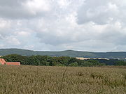
Wiehengebirge
Encyclopedia
North Rhine-Westphalia
North Rhine-Westphalia is the most populous state of Germany, with four of the country's ten largest cities. The state was formed in 1946 as a merger of the northern Rhineland and Westphalia, both formerly part of Prussia. Its capital is Düsseldorf. The state is currently run by a coalition of the...
and Lower Saxony
Lower Saxony
Lower Saxony is a German state situated in north-western Germany and is second in area and fourth in population among the sixteen states of Germany...
in Germany
Germany
Germany , officially the Federal Republic of Germany , is a federal parliamentary republic in Europe. The country consists of 16 states while the capital and largest city is Berlin. Germany covers an area of 357,021 km2 and has a largely temperate seasonal climate...
. The hills run from west to east like a long finger away from the main upland area of the Lower Saxon Hills
Lower Saxon Hills
The Lower Saxon Hills are one the 73 natural regions in Germany defined by the Federal Agency for Nature Conservation . Geographically it covers roughly the same area as the Weser Uplands in its wider sense....
, beginning at the Weser River near Minden
Minden
Minden is a town of about 83,000 inhabitants in the north-east of North Rhine-Westphalia, Germany. The town extends along both sides of the river Weser. It is the capital of the Kreis of Minden-Lübbecke, which is part of the region of Detmold. Minden is the historic political centre of the...
and terminating in the vicinity of Osnabrück
Osnabrück
Osnabrück is a city in Lower Saxony, Germany, some 80 km NNE of Dortmund, 45 km NE of Münster, and some 100 km due west of Hanover. It lies in a valley penned between the Wiehen Hills and the northern tip of the Teutoburg Forest...
.
It is the northern apophysis of the German low mountain ranges in the northern lowlands.
The highest mountain is the Heidbrink near Lübbecke
Lübbecke
Lübbecke is a town in northeast North Rhine-Westphalia in north Germany. This former county town lies on the northern slopes of the Wiehen Hills and has around 26,000 inhabitants. The town is in the Eastwestphalian district of Minden-Lübbecke...
with an altitude of 320 metres (1,049.9 ft).
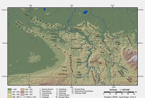
Location
The Wiehen Hills lie within the districts of Osnabrück, Minden-Lübbecke and Herford. Their northern section runs in an east-west direction roughly from the territory of BramscheBramsche
Bramsche is a town in the district of Osnabrück, Lower Saxony, Germany. It is about 20 km north of Osnabrück, at . Population is 30858 .In 1971/72 12 previously independent municipalities were included into the town.*Achmer*Balkum...
(northwest of Osnabrück
Osnabrück
Osnabrück is a city in Lower Saxony, Germany, some 80 km NNE of Dortmund, 45 km NE of Münster, and some 100 km due west of Hanover. It lies in a valley penned between the Wiehen Hills and the northern tip of the Teutoburg Forest...
) via Ostercappeln
Ostercappeln
Ostercappeln is a municipality in the district of Osnabrück, in Lower Saxony, Germany. It is situated in the Wiehengebirge, approx. 15 km northeast of Osnabrück....
, Bad Essen
Bad Essen
Bad Essen is a small municipality and health resort in the district of Osnabrück, in Lower Saxony. Bad Essen with its historical centre is located on the German Framework Road.-Geography:...
, Preußisch Oldendorf
Preußisch Oldendorf
Preußisch Oldendorf is a town in the Minden-Lübbecke district, in North Rhine-Westphalia, Germany. in 1905 the town name Oldendorf was changed officially by putting "Preußisch" in front of it, to make the distinction from other towns with the same name more easy .-Geography:Preußisch Oldendorf is...
and Rödinghausen
Rödinghausen
Rödinghausen is a municipality in the district of Herford, in North Rhine-Westphalia, Germany.-Geography:Rödinghausen is situated on the southern slope of the Wiehengebirge, approx...
, Lübbecke
Lübbecke
Lübbecke is a town in northeast North Rhine-Westphalia in north Germany. This former county town lies on the northern slopes of the Wiehen Hills and has around 26,000 inhabitants. The town is in the Eastwestphalian district of Minden-Lübbecke...
, Hüllhorst
Hüllhorst
Hüllhorst is a municipality in the Minden-Lübbecke district, in North Rhine-Westphalia, Germany.-Geography:Hüllhorst is situated on the south side of the Wiehengebirge, approx...
and Bad Oeynhausen
Bad Oeynhausen
Bad Oeynhausen is a spa town in the Minden-Lübbecke district, in North Rhine-Westphalia, Germany.- Geography :Bad Oeynhausen is located on the banks of the Weser river, which runs along the eastern edges of the town. Bad Oeynhausen has the world's highest carbonated, thermal saltwater fountain,...
as far as the towns of Minden
Minden
Minden is a town of about 83,000 inhabitants in the north-east of North Rhine-Westphalia, Germany. The town extends along both sides of the river Weser. It is the capital of the Kreis of Minden-Lübbecke, which is part of the region of Detmold. Minden is the historic political centre of the...
and Porta Westfalica
Porta Westfalica
Porta Westfalica is a town in the district of Minden-Lübbecke, in North Rhine-Westphalia, Germany. The name “Porta Westfalica” is Latin and means “gate to Westphalia”. Coming from the north, the gorge is the entry to the region of Westphalia...
on the Porta Westfalica gorge
Porta Westfalica (gorge)
thumb|Weser watershedThe Porta Westfalica is a gorge and water gap, where the Weser river runs through the passage between the mountain chains of the Wiehengebirge in the west and the Wesergebirge in the east...
and River Weser. They also graze Bohmte
Bohmte
Bohmte is a municipality in the district of Osnabrück, in Lower Saxony, Germany. It is situated on the river Hunte, approx. 20 km northeast of Osnabrück...
and Hille
Hille
Hille is a community in the Kreis Minden-Lübbecke in the north of East Westphalia, Germany, with approximately 16,000 inhabitants. It was created in 1973 in the framework of the community restructuring of North Rhine-Westphalia through the combining of nine communities of the Minden countryside. ...
to the north. South of the Wiehen Hills lie Osnabrück
Osnabrück
Osnabrück is a city in Lower Saxony, Germany, some 80 km NNE of Dortmund, 45 km NE of Münster, and some 100 km due west of Hanover. It lies in a valley penned between the Wiehen Hills and the northern tip of the Teutoburg Forest...
, Bissendorf
Bissendorf
Bissendorf is a municipality in the district of Osnabrück, in Lower Saxony, Germany. It is situated approx. 9 km southeast of Osnabrück. Population 14,404 ....
, Melle
Melle
-Places:Belgium* Melle, Belgium, a gemeente in East Flanders, FlandersFrance* Melle, Deux-Sèvres, a commune in Poitou-Charentes* Mellé, Ille-et-Vilaine, a commune in BrittanyGermany* Melle, Germany, a Stadt in Osnabrück Landkreis, Lower Saxony...
, Kirchlengern
Kirchlengern
Kirchlengern is a municipality in the district of Herford, in North Rhine-Westphalia, Germany.-Geography:Kirchlengern is situated on the river Else, approx...
, Bünde
Bünde
Bünde is a town in the Herford district, in North Rhine-Westphalia, Germany.-Geography:Bünde is situated between Osnabrück , Hannover and Bielefeld .- Waterways :...
, Löhne
Löhne
Löhne is a town in the district of Herford, in North Rhine-Westphalia, Germany.-Geography:Löhne is situated on the river Werre, approx. 8 km north of Herford and 20 km south-west of Minden.-Neighbouring places:* Hüllhorst* Bad Oeynhausen...
and Bad Oeynhausen
Bad Oeynhausen
Bad Oeynhausen is a spa town in the Minden-Lübbecke district, in North Rhine-Westphalia, Germany.- Geography :Bad Oeynhausen is located on the banks of the Weser river, which runs along the eastern edges of the town. Bad Oeynhausen has the world's highest carbonated, thermal saltwater fountain,...
.
The Wiehen Hills form the northwestern boundary of the Lower Saxon Hills
Lower Saxon Hills
The Lower Saxon Hills are one the 73 natural regions in Germany defined by the Federal Agency for Nature Conservation . Geographically it covers roughly the same area as the Weser Uplands in its wider sense....
to which they belong geographically, together with the Westphalian part of the ridge.
Whilst the eastern end of the hill chain is clearly defined by the Porta Westfalica gorge
Porta Westfalica (gorge)
thumb|Weser watershedThe Porta Westfalica is a gorge and water gap, where the Weser river runs through the passage between the mountain chains of the Wiehengebirge in the west and the Wesergebirge in the east...
and the hill of Wittekindsberg
Wittekindsberg
The Wittekindsberg is a hill, , which forms the easternmost peak of the Wiehen Hills and is also the western guardian of the Weser gorge, the Porta Westfalica, in North Rhine-Westphalia ....
, this is not so simple for its western extremity. To the west the Wiehen descends gradually, transitioning from a hilly ridge into a chain of hillock
Hillock
A hillock or knoll is a small hill, usually separated from a larger group of hills such as a range. Hillocks are similar in their distribution and size to small mesas or buttes. The term is largely a British one...
s and then descending almost imperceptibly into the plain
Plain
In geography, a plain is land with relatively low relief, that is flat or gently rolling. Prairies and steppes are types of plains, and the archetype for a plain is often thought of as a grassland, but plains in their natural state may also be covered in shrublands, woodland and forest, or...
. South of Bramsche the ridge rises again at the Penter Egge to a height of 99 metre, but 2.5 km further west it reaches the level of the surrounding countryside. The waterways of the Mittelland Canal and Osnabrück Canal
Osnabrück Canal
The Osnabrück Canal or SKO, is an artificial waterway, about 14.5 km long, that links the Mittelland Canal in central Germany with the port in the town of Osnabrück...
running away to the south appear to mark the end of the hill range, but west of these canals is the 82 metre high Larberger Egge which forms the westernmost cornerstone of the Wiehen Hills, rising just 2 km northeast of the boundary with the province of Münster. Contrary to popular assumption, Ibbenbüren
Ibbenbüren
Ibbenbüren or Ibbenbueren is a medium-sized town in the district of Steinfurt, in North Rhine-Westphalia, Germany. It is on position 185 of the largest cities in Germany and the largest city in Tecklenburger Land.-Geography:...
is no longer considered to be situated by the Wiehen Hills and the Ibbenbüren Plateau (Ibbenbürener Bergplatte comprising the Schafberg, etc.) is no longer part of the Wiehen. Geological reasons, according to current research, do not support such an assumption.
To the north, the Wiehen descends to the North German Plain
North German plain
The North German Plain or Northern Lowland is one of the major geographical regions of Germany. It is the German part of the North European Plain...
into a region known as the Lübbecke Loessland
Lübbecke Loessland
The Lübbecke Loessland is a natural region that is mainly situated in northeastern North Rhine-Westphalia but with a small area also lying in the western part of Lower Saxony in Germany. It is a belt of land, covered by loess, about 2 to 5 km wide and around 35 km long, that lies just north of the...
. On the banks of the Weser, opposite Porta Westfalica, lies the Wesergebirge
Wesergebirge
The Wesergebirge is a low mountain chain up to high in the Weser Uplands in the German states of North Rhine-Westphalia and Lower Saxony....
, which is the eastern continuation of the Wiehen Hills. This ridge is of similar geological construction and runs as far as the area of Hessisch Oldendorf
Hessisch Oldendorf
Hessisch Oldendorf is a town in the Hamelin-Pyrmont district, in Lower Saxony, Germany. It is situated on the river Weser, approx. 10 km northwest of Hamelin. The adjective "Hessisch" is used since 1905, to distinguish it from other towns named Oldendorf. Hessisch Oldendorf was part of...
to the Süntel
Süntel
The Süntel is a massif in the German Central Uplands that is up to . It forms part of the Weser Uplands in Lower Saxony southwest of Hanover and north of Hamelin.-Geographical location:...
hills. Southeast of the Wiehen Hills are the Lippe Uplands
Lippe Uplands
The Lippe Uplands is a range of hills in Ostwestfalen-Lippe within the administrative district of Detmold in the German state of North Rhine-Westphalia.-Geography:...
, to the south the Ravensberg Hills, to the southwest in the area of the Tecklenburg Land are the northern foothills of the Teutoburg Forest
Teutoburg Forest
The Teutoburg Forest is a range of low, forested mountains in the German states of Lower Saxony and North Rhine-Westphalia which used to be believed to be the scene of a decisive battle in AD 9...
, and to the northwest are the hills of the Gehn and the Ankum Heights
Ankum Heights
The Ankum Heights , also called the Fürstenau Hills , are a ridge of hills up to 140 m high in the western part of the state of Lower Saxony on the North German Plain.- Geography :...
, the Damme Hills
Damme Hills
The Damme Hills are a high, wooded ridge, up to , in the Oldenburg Münsterland in the southern part of the district of Vechta, in western Lower Saxony, Germany.- Location :...
and the Stemweder Berg
Stemweder Berg
The Stemweder Berg is a ridge up to on the border of North Rhine-Westphalia and Lower Saxony in Germany and is the northernmost and smallest of Germany's Central Uplands ranges....
. North of the northwestern tip of the Wiehen liest the great bog of the Großes Moor.
Northernmost German uplands
According to folklore, regionally-conscious residents around the hills usually admit grudgingly that the Wiehen Hills are not particularly high. In the same breath, they may assert, often with a raised index finger and an odd emphasis on the word gebirge ("hill/mountain range"), that they are the northernmost hill range in Germany and the one closest to the sea.Whether this assertion is true is in fact a matter of definition. It clearly ignores the morainic ridges
Terminal moraine
A terminal moraine, also called end moraine, is a moraine that forms at the end of the glacier called the snout.Terminal moraines mark the maximum advance of the glacier. An end moraine is at the present boundary of the glacier....
further north and closer to the sea, as well as other true uplands such as the Stemweder Berg
Stemweder Berg
The Stemweder Berg is a ridge up to on the border of North Rhine-Westphalia and Lower Saxony in Germany and is the northernmost and smallest of Germany's Central Uplands ranges....
or the Rehburg Hills
Rehburg Hills
The Rehburg Hills are a hill range, up to , in the districts of Nienburg and Schaumburg in Lower Saxony, Germany.- Origin of the name :The Rehburg Hills and their foothills give the impression of being several small neighbouring hills. The little village of Bad Rehburg was a well-known spa and...
. Of course, these hills are much lower and do not reach the 200-metre contour line.
Of the higher, say up to 300 metre high uplands, the northern foothills of Deister
Deister
The Deister is a chain of hills in the German state of Lower Saxony, about 15 mi southwest of the city of Hanover. It runs in a north-westerly direction from Springe in the south to Rodenberg in the north. The next the chain of hills that attaches in the south is called Small Deister...
and Bückeberge extend farther north than the eastern Wiehen range. However, it is also true that the highest part of the Wiehen Hills at Lübbecke has the most northerly hill over 300 metres in Germany. The almost 320 metre high Heidbrink is also the northernmost "300" on the European continent between the central Ural Mountains
Ural Mountains
The Ural Mountains , or simply the Urals, are a mountain range that runs approximately from north to south through western Russia, from the coast of the Arctic Ocean to the Ural River and northwestern Kazakhstan. Their eastern side is usually considered the natural boundary between Europe and Asia...
and the Atlantic, i.e. excluding the British Isles and Fennoscandinavia.