

Manifold Way
Encyclopedia
Staffordshire
Staffordshire is a landlocked county in the West Midlands region of England. For Eurostat purposes, the county is a NUTS 3 region and is one of four counties or unitary districts that comprise the "Shropshire and Staffordshire" NUTS 2 region. Part of the National Forest lies within its borders...
, England. Some 8 miles (12.9 km) in length, it runs from Hulme End
Hulme End
- Introduction :Hulme End is a small hamlet in Staffordshire, England. It is located in the Peak District National Park about 10 miles north of Ashbourne...
in the north to Waterhouses
Waterhouses, Staffordshire
Waterhouses is a village in the south of the Staffordshire Peak District.It is around 8 miles from Leek and Ashbourne, being nearly the halfway point between the two towns on the A523 road, which roughly follows the southern boundary of the Peak District National Park...
in the south, mostly through the Manifold Valley and the valley of its only tributary, the River Hamps
River Hamps
The River Hamps is a river in Staffordshire, England. It is tributary of the River Manifold, which itself flows into the River Dove near Ilam. For its entire length the river flows through the Peak District National Park.- Etymology :...
, following the route of the former Leek and Manifold Valley Light Railway
Leek and Manifold Valley Light Railway
The Leek and Manifold Valley Light Railway was a narrow gauge railway in Staffordshire, Great Britain that operated between 1904 and 1934. When in operation, the line mainly carried milk from dairies in the region, acting as a feeder to the standard gauge system. It also provided passenger...
, a gauge line which closed in 1934 after a short life.
The Manifold Way was opened in July 1937 by Staffordshire County Council after the LMS
London, Midland and Scottish Railway
The London Midland and Scottish Railway was a British railway company. It was formed on 1 January 1923 under the Railways Act of 1921, which required the grouping of over 120 separate railway companies into just four...
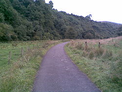
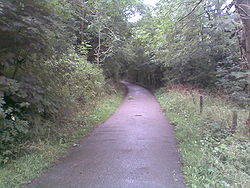
handed over the trackbed to them. Tarmacked throughout, and with only a slight downhill gradient from north to south, the path is also ideal for wheelchair users, prams, etc. However, for about 1½ miles, near Wetton Mill
Wetton, Staffordshire
Wetton is a village in the Peak District National Park, North Staffordshire, at the top of the east side of the Manifold Valley. The population recorded in the 2001 Census was 157. This article describes the location, some of the main features of the village, and a number of places of historical or...
, the route is shared with motor traffic where the B-road has been diverted along its route. This section includes Swainsley tunnel.
Unlike other nearby walk- and cycleways, such as the Tissington Trail
Tissington Trail
right|thumb|200px|The Trail at the site of the former Tissington station, now a picnic site.The Tissington Trail is a bridleway and walk/cycle path in Derbyshire, England...
and the High Peak Trail, which cross elevated areas of the Peak District
Peak District
The Peak District is an upland area in central and northern England, lying mainly in northern Derbyshire, but also covering parts of Cheshire, Greater Manchester, Staffordshire, and South and West Yorkshire....
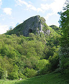
, the Manifold Way follows the valley bottoms and is altogether more sheltered. The path passes through attractive scenery, and indeed tourism was one of the reasons for the original construction of the line. Popular locations along the route include Thor's Cave
Thor's Cave
Thor's Cave is a natural cavern located at in the Manifold Valley of the White Peak in Staffordshire, England. It is classified as a Karst cave...
, the mill at Wetton Hill and Beeston Tor
Beeston Tor
Beeston Tor is a limestone cliff in Staffordshire. It overlooks the confluence of the River Hamps with the River Manifold, and is popular with climbers....
. A little to the east lies Dovedale
Dovedale
Dovedale is a popular dale in the Peak District, England. It is owned by the National Trust, and annually attracts a million visitors. The valley is cut by the River Dove and runs for just over between Milldale in the north and a wooded ravine near Thorpe Cloud and Bunster Hill in the south...
, a better-known beauty spot.
The Manifold Way does not pass through any significant centres of population along its route; indeed it was once described by a railway worker as a line which started in the middle of nowhere, and ended up in the same place! Whilst the railway did serve villages and hamlets along its route, these were mostly located about a mile above the valley, a fact which contributed to the railway's ultimate demise. This, however, is all to the benefit of the walker today.
Whilst walking along the Manifold Way the rivers Manifold and Hamps are never far away - in fact there are dozens of small bridges crossing them. However, over the summer months the River Manifold disappears down a swallet or sink hole near Wetton Mill, to reappear some distance way, at Ilam
Ilam, Staffordshire
Ilam is a village in the Staffordshire Peak District, lying on the River Manifold. This article describes some of the main features of the village and surroundings.- Ilam village :...
.
In all there were ten stations and halts along the line. Most had some sort of waiting room, and also a siding, but were only small affairs. The sites of the halts can be seen today, and there is also some evidence of the loading platforms, especially at Ecton
Ecton
Ecton is a village and civil parish in the Borough of Wellingborough in Northamptonshire, England. The village is just east of Northampton, just off the A4500 road. It was one of the first villages in Northamptonshire to be given conservation status...
, where the dairy provided much business for the railway.
The valley-bottom nature of the Manifold Way offers much to see in the way of flora
Flora
Flora is the plant life occurring in a particular region or time, generally the naturally occurring or indigenous—native plant life. The corresponding term for animals is fauna.-Etymology:...
and fauna
Fauna
Fauna or faunæ is all of the animal life of any particular region or time. The corresponding term for plants is flora.Zoologists and paleontologists use fauna to refer to a typical collection of animals found in a specific time or place, e.g. the "Sonoran Desert fauna" or the "Burgess shale fauna"...
, and animal wildlife. Apart from the official Manifold Way route itself, the area also lends itself to many circular walking routes which utilize the route.
The Manifold Way passes through some areas which comprise the South Peak Estate
South Peak Estate
The South Peak Estate of the National Trust comprises several land holdings in the Southern Peak District. Some of these, like Shining Cliff Wood and Alport Height, are just outside the National Park boundary...
, land holdings owned by the National Trust
National Trust for Places of Historic Interest or Natural Beauty
The National Trust for Places of Historic Interest or Natural Beauty, usually known as the National Trust, is a conservation organisation in England, Wales and Northern Ireland...
.
At Hulme End, the old station building has been restored as a visitor centre, and the cafe/shop at Wetton Mill is a popular spot. At Ecton Hill lie the remains of a 4,000-year-old copper mine, and the caves at Beeston Tor have revealed Neolithic
Neolithic
The Neolithic Age, Era, or Period, or New Stone Age, was a period in the development of human technology, beginning about 9500 BC in some parts of the Middle East, and later in other parts of the world. It is traditionally considered as the last part of the Stone Age...
and Bronze Age
Bronze Age
The Bronze Age is a period characterized by the use of copper and its alloy bronze as the chief hard materials in the manufacture of some implements and weapons. Chronologically, it stands between the Stone Age and Iron Age...
remains.
The trackway is well maintained and there are a number of car parks and refreshment facilities (some mobile) situated at convenient intervals along its length.
There are campsites at Hulme End and Wetton Village
Wetton, Staffordshire
Wetton is a village in the Peak District National Park, North Staffordshire, at the top of the east side of the Manifold Valley. The population recorded in the 2001 Census was 157. This article describes the location, some of the main features of the village, and a number of places of historical or...
, and bikes can be hired at Waterhouses, at the southern end of the trail.