
Tissington Trail
Encyclopedia
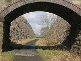
feb2006.jpg)
Rail trail
A rail trail is the conversion of a disused railway easement into a multi-use path, typically for walking, cycling and sometimes horse riding. The characteristics of former tracks—flat, long, frequently running through historical areas—are appealing for various development. The term sometimes also...
in Derbyshire
Derbyshire
Derbyshire is a county in the East Midlands of England. A substantial portion of the Peak District National Park lies within Derbyshire. The northern part of Derbyshire overlaps with the Pennines, a famous chain of hills and mountains. The county contains within its boundary of approx...
, England
England
England is a country that is part of the United Kingdom. It shares land borders with Scotland to the north and Wales to the west; the Irish Sea is to the north west, the Celtic Sea to the south west, with the North Sea to the east and the English Channel to the south separating it from continental...
. Opened in 1971, and now a part of the National Cycle Network
National Cycle Network
The National Cycle Network is a network of cycle routes in the United Kingdom.The National Cycle Network was created by the charity Sustrans , and aided by a £42.5 million National Lottery grant. In 2005 it was used for over 230 million trips.Many routes hope to minimise contact with motor...
, it runs for 13 miles (21 km) from Parsley Hay in the north to Ashbourne
Ashbourne, Derbyshire
Ashbourne is a small market town in the Derbyshire Dales, England. It has a population of 10,302.The town advertises itself as 'The Gateway to Dovedale'.- Local customs :...
in the south, along part of the trackbed of the former railway line connecting Ashbourne to Buxton
Buxton
Buxton is a spa town in Derbyshire, England. It has the highest elevation of any market town in England. Located close to the county boundary with Cheshire to the west and Staffordshire to the south, Buxton is described as "the gateway to the Peak District National Park"...
. It takes its name from the village of Tissington
Tissington
Tissington is a village in Derbyshire, England. It is part of the estate of Tissington Hall, owned by the FitzHerbert family since 1465. It is regarded as one of the most picturesque English villages and is a popular tourist attraction, particularly during its well dressing week. It also gives its...
, which it skirts.
At Parsley Hay, a small settlement to the north-east of Hartington
Hartington
Hartington is a village in the Derbyshire Peak District, England, lying on the River Dove close to the Staffordshire border. According to the 2001 census, the parish of Hartington Town Quarter, which also includes Pilsbury, had a population of 345...
, it is joined by the High Peak Trail, a walk/cycle trail which runs 17 miles (27 km) in total from High Peak Junction
High Peak Junction
High Peak Junction, near Cromford, Derbyshire, England, is the name now used to describe the site where the former Cromford and High Peak Railway , whose workshops were located here, meets the Cromford Canal...
near Cromford
Cromford
Cromford is a village, two miles to the south of Matlock in the Derbyshire Dales district in Derbyshire, England. It is principally known for its historical connection with Richard Arkwright, and the Cromford Mill which he built here in 1771...
, Matlock, to Dowlow, near Buxton
Buxton
Buxton is a spa town in Derbyshire, England. It has the highest elevation of any market town in England. Located close to the county boundary with Cheshire to the west and Staffordshire to the south, Buxton is described as "the gateway to the Peak District National Park"...
.
The trail has a firm crushed limestone surface which makes it ideal for cyclists and walkers
Pedestrian
A pedestrian is a person traveling on foot, whether walking or running. In some communities, those traveling using roller skates or skateboards are also considered to be pedestrians. In modern times, the term mostly refers to someone walking on a road or footpath, but this was not the case...
of all ability, including wheelchair
Wheelchair
A wheelchair is a chair with wheels, designed to be a replacement for walking. The device comes in variations where it is propelled by motors or by the seated occupant turning the rear wheels by hand. Often there are handles behind the seat for someone else to do the pushing...
users, assisted by easy level access onto the trail at many points along its route. The elevated nature of the line (at Parsley Hay it is over 1000 feet (304.8 m) in height) affords good views, but the trail can also be exposed in poor weather. Although not greatly noticeable, the trail runs gently downhill from Parsley Hay southwards. Note however that about 1/4 mi north of the cycle hire centre at Mapleton Lane, Ashbourne, the trail dips down and up where a viaduct has been removed; both slopes are about 40 m (131 ft) long with gradients of 1:9.
Hartington signal box, beside the trail, though some distance from the village, has been converted into an Information Centre, open in summer on Saturdays, Sundays and Bank Holidays.
The Park Authority operates cycle hire at both ends of the Trail, i.e. at Parsley Hay and Ashbourne.
From Hartington station northwards, the route is also part of the Pennine Bridleway
Pennine Bridleway
The Pennine Bridleway is a new National Trail under designation in Northern England.It runs roughly parallel with the Pennine Way but provides access for horseback riders and cyclists as well as walkers. The trail is around long; through Derbyshire to the South Pennines, the Mary Towneley Loop...
, a 130 miles (209 km) leisure route which includes 73 miles (117 km) through Derbyshire to the South Pennines. The Bridleway has two southern starting points, the other being at Middleton Top, near Cromford, on the High Peak Trail.
Facilities
- At Parsley Hay (map ref: SK 146637) there is a car park, toilets, picnic site, visitor information and cycle hire. There is direct level access to the trail.
- At Hartington Station (map ref: SK 149610) there is a car park with toilets and picnic site. There is level access onto the trail.
- At Ruby Wood (map ref: SK 149604) there is a car park and a picnic site.
- At Alsop-en-le-Dale Station (map Ref: SK 155549) there is a car park with picnic site. There is level access onto the trail.
- At Tissington Station (map ref: SK 177520) there is a car park, with toilets and picnic site.
- At Thorpe Station (map ref: SK 165503) there is a small car park and picnic site, with level access onto the trail.
- At Narlows Lane, near Thorpe (map ref: SK 163504) there is a car park.
- At Mapleton Lane, near Ashbourne (map ref: SK 175473) there is a car park, toilets, and cycle hire.
History of the route
Built by the LNWR, the line opened in 1899, and linked with the Cromford and High Peak RailwayCromford and High Peak Railway
The Cromford and High Peak Railway in Derbyshire, England, was completed in 1831, to carry minerals and goods between the Cromford Canal wharf at High Peak Junction and the Peak Forest Canal at Whaley Bridge -Origins:...
at Parsley Hay, a line completed nearly 70 years earlier to link the Cromford Canal
Cromford Canal
The Cromford Canal ran 14.5 miles from Cromford to the Erewash Canal in Derbyshire, England with a branch to Pinxton. Built by William Jessop with the assistance of Benjamin Outram, its alignment included four tunnels and 14 locks....
wharf at High Peak Junction with the Peak Forest Canal
Peak Forest Canal
The Peak Forest Canal, is a narrow locked artificial waterway in northern England. It is long and forms part of the connected English/Welsh inland waterway network.-General description:...
at Whaley Bridge
Whaley Bridge
Whaley Bridge is a small town and civil parish in the High Peak district of Derbyshire, England, situated on the River Goyt. Whaley Bridge is approximately south of Manchester, north of Buxton , east of Macclesfield and west of Sheffield, and had a population of 6,226 at the 2001 census. This...
. It was the last of the railways to be built in the Peak District. Whilst the section from Parsley Hay to Ashbourne was single track (from Parsley Hay north to Buxton it was double) the formation was constructed to allow for doubling if necessary, but this never happened. There were passing loops at Hartington, Alsop-en-le-Dale, Tissington and Thorpe Cloud.
Despite the relatively short length of this branch line, it was deservedly popular with walkers and ramblers, enjoying its heyday in the 1930s. Apart from the elevated views over the Peak itself, a large attraction was that this line passed close to Dovedale
Dovedale
Dovedale is a popular dale in the Peak District, England. It is owned by the National Trust, and annually attracts a million visitors. The valley is cut by the River Dove and runs for just over between Milldale in the north and a wooded ravine near Thorpe Cloud and Bunster Hill in the south...
. The line for a time also carried a through-service (i.e. without changing carriages) for passengers from London Euston, (via Nuneaton
Nuneaton
Nuneaton is the largest town in the Borough of Nuneaton and Bedworth and in the English county of Warwickshire.Nuneaton is most famous for its associations with the 19th century author George Eliot, who was born on a farm on the Arbury Estate just outside Nuneaton in 1819 and lived in the town for...
, Uttoxeter
Uttoxeter
Uttoxeter is a historic market town in Staffordshire, in the West Midlands region of England. The current population is approximately 13,711, though new developments in the town will increase this figure. Uttoxeter lies close to the River Dove and is near the cities of Stoke-on-Trent, Derby and...
and Ashbourne), to Buxton and Manchester. A daily train also transported local milk to London. However, the line suffered from passing through a sparsely populated area, and it was closed to regular passenger traffic in 1954, and all services between Ashbourne and Hartington, including excursion traffic and specials (such as run during bad weather, or Well dressing
Well dressing
Well dressing is a summer custom practised in rural England in which wells, springs or other water sources are decorated with designs created from flower petals...
specials), ceased in October 1963. The route between Hartington and Parsley Hay survived until October 1967.
See also
- High Peak Trail
- Monsal TrailMonsal TrailThe Monsal Trail is a cycle, horse riding and walking trail in the Derbyshire Peak District.-Route description:It follows a section of the former Manchester, Buxton, Matlock and Midlands Junction Railway, built by the Midland Railway in 1863 to link Manchester with London...
- Cromford and High Peak RailwayCromford and High Peak RailwayThe Cromford and High Peak Railway in Derbyshire, England, was completed in 1831, to carry minerals and goods between the Cromford Canal wharf at High Peak Junction and the Peak Forest Canal at Whaley Bridge -Origins:...
- Cycleways in EnglandCycleways in EnglandCycleways in England is a list of recreational cycleways in England.*The Bristol & Bath Railway Path*The Camel Trail, North Cornwall*The , Cheshire*Clay Trails, Cornwall*Mineral Tramway Trails, Cornwall*Great Flat Lode trail, Cornwall...