

High Peak Trail
Encyclopedia
Rail trail
A rail trail is the conversion of a disused railway easement into a multi-use path, typically for walking, cycling and sometimes horse riding. The characteristics of former tracks—flat, long, frequently running through historical areas—are appealing for various development. The term sometimes also...
for walkers, cyclists and horse riders in the Peak District
Peak District
The Peak District is an upland area in central and northern England, lying mainly in northern Derbyshire, but also covering parts of Cheshire, Greater Manchester, Staffordshire, and South and West Yorkshire....
. Running from Dowlow , near Buxton
Buxton
Buxton is a spa town in Derbyshire, England. It has the highest elevation of any market town in England. Located close to the county boundary with Cheshire to the west and Staffordshire to the south, Buxton is described as "the gateway to the Peak District National Park"...
, to High Peak Junction
High Peak Junction
High Peak Junction, near Cromford, Derbyshire, England, is the name now used to describe the site where the former Cromford and High Peak Railway , whose workshops were located here, meets the Cromford Canal...
, Cromford
Cromford
Cromford is a village, two miles to the south of Matlock in the Derbyshire Dales district in Derbyshire, England. It is principally known for its historical connection with Richard Arkwright, and the Cromford Mill which he built here in 1771...
, it follows the trackbed of the former Cromford and High Peak Railway
Cromford and High Peak Railway
The Cromford and High Peak Railway in Derbyshire, England, was completed in 1831, to carry minerals and goods between the Cromford Canal wharf at High Peak Junction and the Peak Forest Canal at Whaley Bridge -Origins:...
, which was completed in 1831 to carry mineral
Mineral
A mineral is a naturally occurring solid chemical substance formed through biogeochemical processes, having characteristic chemical composition, highly ordered atomic structure, and specific physical properties. By comparison, a rock is an aggregate of minerals and/or mineraloids and does not...
s and goods between the Cromford Canal
Cromford Canal
The Cromford Canal ran 14.5 miles from Cromford to the Erewash Canal in Derbyshire, England with a branch to Pinxton. Built by William Jessop with the assistance of Benjamin Outram, its alignment included four tunnels and 14 locks....
wharf at High Peak Junction and the Peak Forest Canal
Peak Forest Canal
The Peak Forest Canal, is a narrow locked artificial waterway in northern England. It is long and forms part of the connected English/Welsh inland waterway network.-General description:...
at Whaley Bridge
Whaley Bridge
Whaley Bridge is a small town and civil parish in the High Peak district of Derbyshire, England, situated on the River Goyt. Whaley Bridge is approximately south of Manchester, north of Buxton , east of Macclesfield and west of Sheffield, and had a population of 6,226 at the 2001 census. This...
.
Closure of the line occurred during the Beeching era
Beeching Axe
The Beeching Axe or the Beeching Cuts are informal names for the British Government's attempt in the 1960s to reduce the cost of running British Railways, the nationalised railway system in the United Kingdom. The name is that of the main author of The Reshaping of British Railways, Dr Richard...
, with the first section of the line closing in 1963 (i.e. the Middleton Incline), with full closure in 1967.
In 1971 the Peak Park Planning Board and Derbyshire County Council bought the largest part of the trackbed and, in partnership with the Countryside Commission
Countryside Commission
The Countryside Commission was a statutory body in England and Wales, and later in England only...
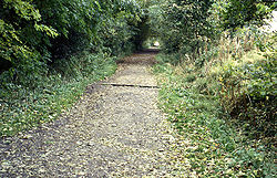
, adapted it for its current leisure use. The trail has a crushed limestone surface which makes it ideal for all users, including wheelchair
Wheelchair
A wheelchair is a chair with wheels, designed to be a replacement for walking. The device comes in variations where it is propelled by motors or by the seated occupant turning the rear wheels by hand. Often there are handles behind the seat for someone else to do the pushing...
use, assisted by level access onto the trail at various points along its route.
The High Peak Trail is now a national route of the National Cycle Network
National Cycle Network
The National Cycle Network is a network of cycle routes in the United Kingdom.The National Cycle Network was created by the charity Sustrans , and aided by a £42.5 million National Lottery grant. In 2005 it was used for over 230 million trips.Many routes hope to minimise contact with motor...
.
The elevated nature of the trail (the highest part of the line is at Ladmanlow, at a height of 1266 ft (385.9 m)) affords many splendid views across the countryside. However, these higher sections can also be very exposed in poor weather. The original railway incorporated a number of inclines at its northern and southern ends, and whilst much of the trail is fairly level, these sections are naturally steeper.
At Parsley Hay, about 5 mi (8 km) SW of Bakewell
Bakewell
Bakewell is a small market town in the Derbyshire Dales district of Derbyshire, England, deriving its name from 'Beadeca's Well'. It is the only town included in the Peak District National Park, and is well known for the local confection Bakewell Pudding...
, the High Peak Trail is joined by the 13 miles (20.9 km) Tissington Trail
Tissington Trail
right|thumb|200px|The Trail at the site of the former Tissington station, now a picnic site.The Tissington Trail is a bridleway and walk/cycle path in Derbyshire, England...
, another route of the National Cycle Network, which was formerly the railway branch line to Ashbourne
Ashbourne Line
The Ashbourne Line was a railway from Buxton via Ashbourne to Uttoxeter. It was built by the London and North Western Railway using a section of the Cromford and High Peak Railway and it joined the North Staffordshire Railway at Ashbourne, proceeding to Uttoxeter with a junction onto the main...
.
The High Peak Trail (and part of the Tissington Trail) are also designated part of the Pennine Bridleway
Pennine Bridleway
The Pennine Bridleway is a new National Trail under designation in Northern England.It runs roughly parallel with the Pennine Way but provides access for horseback riders and cyclists as well as walkers. The trail is around long; through Derbyshire to the South Pennines, the Mary Towneley Loop...
, a 130 miles (209.2 km) leisure route which starts at Middleton Top, near Cromford, and includes 73 miles (117.5 km) through Derbyshire to the South Pennines. The Trail also forms part of the Midshires Way
Midshires Way
The Midshires Way is a long distance footpath and bridleway that runs for through Middle England from Bledlow in Buckinghamshire to Stockport, Greater Manchester....
, a long distance footpath and bridleway which runs for 225 miles (362.1 km) through Middle England
Middle England
The phrase "Middle England" is a socio-political and geographical term which originally indicated the central region of England, now almost always referred to as the "Midlands"....
from Bledlow
Bledlow
Bledlow is a village in the civil parish of Bledlow-cum-Saunderton in Buckinghamshire, England. It is situated about a mile and a half WSW of Princes Risborough, and on the border with Oxfordshire....
to Stockport
Stockport
Stockport is a town in Greater Manchester, England. It lies on elevated ground southeast of Manchester city centre, at the point where the rivers Goyt and Tame join and create the River Mersey. Stockport is the largest settlement in the metropolitan borough of the same name...
.
Access and facilities on the trail
- At HurdlowHurdlow railway stationHurdlow railway station was near to the hamlet of Hurdlow to the south east of Buxton, Derbyshire on the LNWR line to Ashbourne and the south.-History:...
(map ref. SK 128659), at the northern end of the trail, there is parking and level access onto the trail. Picnic tables are provided.
- At Parsley Hay (map ref. SK 146637), where the trail is joined by the Tissington Trail, there is direct access from the car park to the trail. Facilities include toilets, a picnic site, visitor information, and cycle hire.
- At FridenFriden, DerbyshireFriden is a hamlet in the civil parish of Hartington Nether Quarter, Derbyshire, England. It is located 11 miles south-east of Buxton just off the Newhaven to Cromford Via Gellia road and lies within the Peak District National Park....
(map ref. SK 172607) there is a car park giving level access onto the trail. There is a picnic table.
- At MinninglowMinninglowMinninglow is a hill in the Peak District National Park in Derbyshire, located within the White Peak area at grid ref SK209573. Within the clump of trees crowning the hill is a round barrow containing Neolithic burial chambers....
(map ref. SK 194581) there is a car park and picnic site, with level access onto the trail.
- At Middleton Top there is a visitor centre, with car park and toilets. Cycles can also be hired here.
- At Black Rocks there is a car park, toilets, and shop for light refreshments.
- At High Peak Junction there is a Visitor Centre and shop. Light refreshments can be purchased and there are picnic tables outside. Lea Road car park, over the river, is accessible by footbridge.
- Nearby is the National Stone Centre, Wirksworth.
A Day Out
A popular day out includes parking the car at Wirksworth StationWirksworth railway station
Wirksworth Railway Station is a heritage railway station that serves the town of Wirksworth in Derbyshire. It was the former terminus of the Midland Railway Wirksworth branch line, leaving the Midland Main Line at...
on the Ecclesbourne Valley Railway
Ecclesbourne Valley Railway
The Ecclesbourne Valley Railway is a long heritage railway in Derbyshire, the headquarters of the railway centre around Wirksworth station and services operate between Wirksworth and Duffield and Wirksworth and Ravenstor...
, taking the heritage train up the short but steep 1 in 27 incline to Ravenstor
Ravenstor railway station
Ravenstor Railway Station is a Heritage railway station at the northernmost limit of the Ecclesbourne Valley Railway, Wirksworth, Derbyshire.-History:...
and then walking up to the National Stone Centre. From the Stone Centre, visitors can join the start of the High Peak Trail.