
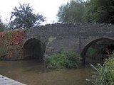
Wellow Brook, Somerset
Encyclopedia
The Wellow brook is a small river in Somerset
, England
.
It rises near Ston Easton Park in the village of Ston Easton
and flows east to Midsomer Norton
. West of Radstock
, it is joined by the River Somer
and a tributary from Kilmersdon
to the south. It then flows through Wellow
before joining the Cam Brook
at Midford
to form Midford Brook
before joining the River Avon
close to the Dundas Aqueduct
.
Along its length are the remains of the Somerset Coal Canal
which served the Somerset coalfield
.
The valley sides are rounded and undulating through erosion. There are several springs dotted along the valley sides and the resultant streams are often lined with trees. The junction of the valley sides with the base is usually gentle and rounded and the valley floors are narrow but flat with the brooks meandering freely across their flood plain. The brook is quite deep in places and frequently has steep sides. This was taken advantage of in making anti-tank defences during World War II
when a large number of concrete
bunker
s known as pillboxes were built as part of the GHQ Line
to defend against an expected German invasion
.
The area is of interest to the Cam Valley Wildlife Group.
Somerset
The ceremonial and non-metropolitan county of Somerset in South West England borders Bristol and Gloucestershire to the north, Wiltshire to the east, Dorset to the south-east, and Devon to the south-west. It is partly bounded to the north and west by the Bristol Channel and the estuary of the...
, England
England
England is a country that is part of the United Kingdom. It shares land borders with Scotland to the north and Wales to the west; the Irish Sea is to the north west, the Celtic Sea to the south west, with the North Sea to the east and the English Channel to the south separating it from continental...
.
It rises near Ston Easton Park in the village of Ston Easton
Ston Easton
Ston Easton is a linear village and civil parish in the English county of Somerset. It is southwest of Bath and north of Shepton Mallet. It forms part of the Mendip district and lies along the A37 road south of the cities of Bristol and Bath and to the west of the town of Midsomer Norton...
and flows east to Midsomer Norton
Midsomer Norton
Midsomer Norton is a town near the Mendip Hills in Somerset, England, south-west of Bath, north-east of Wells, north-west of Frome, and south-east of Bristol. It has a population of 10,458. Along with Radstock and Westfield it used to be part of the conurbation and large civil parish of Norton...
. West of Radstock
Radstock
Radstock is a town in Somerset, England, south west of Bath, and north west of Frome. It is within the unitary authority of Bath and North East Somerset and had a population of 5,275 according to the 2001 Census...
, it is joined by the River Somer
River Somer
The River Somer is a small river in Somerset, England.It rises at Chilcompton and flows to Midsomer Norton where it joins the Wellow Brook, which flows through Wellow and joins the Cam Brook at Midford to form Midford Brook before joining the River Avon close to the Dundas Aqueduct and the remains...
and a tributary from Kilmersdon
Kilmersdon
Kilmersdon is a small village located in the north of Somerset between the towns of Radstock and Frome. The settlement is recorded in William I's Domesday book and dates back at least 1,000 years; though the core of the village dates from the mid nineteenth century.-History:The name Kilmersdon...
to the south. It then flows through Wellow
Wellow, Somerset
Wellow is a village and civil parish in Somerset, England, about south of Bath. The parish, which includes the hamlet of Twinhoe has a population of 511...
before joining the Cam Brook
Cam Brook, Somerset
The Cam brook is a small river in Somerset, England.It rises near Hinton Blewitt, flows through Cameley, Temple Cloud, Camerton, Dunkerton and Combe Hay...
at Midford
Midford
Midford is a village approximately miles south south east of Bath, Somerset, England within the Cotswold Area of Outstanding Natural Beauty...
to form Midford Brook
Midford Brook
Midford Brook is a small river in Somerset, England.It is formed by convergence of the Wellow Brook and Cam Brook at Midford before passing Tucking Mill and joining the River Avon close to the Dundas Aqueduct and the remains of the Somerset Coal Canal....
before joining the River Avon
River Avon, Bristol
The River Avon is an English river in the south west of the country. To distinguish it from a number of other River Avons in Britain, this river is often also known as the Lower Avon or Bristol Avon...
close to the Dundas Aqueduct
Dundas Aqueduct
Dundas Aqueduct carries the Kennet and Avon Canal over the River Avon and the Wessex Main Line railway from Bath to Westbury, near Limpley Stoke in Wiltshire, England....
.
Along its length are the remains of the Somerset Coal Canal
Somerset Coal Canal
The Somerset Coal Canal was a narrow canal in England, built around 1800 from basins at Paulton and Timsbury via Camerton, an aqueduct at Dunkerton, Combe Hay, Midford and Monkton Combe to Limpley Stoke where it joined the Kennet and Avon Canal...
which served the Somerset coalfield
Somerset coalfield
The Somerset Coalfield included pits in the North Somerset, England, area where coal was mined from the 15th century until 1973.It is part of a wider coalfield which covered northern Somerset and southern Gloucestershire. It stretched from Cromhall in the north to the Mendip Hills in the south, and...
.
The valley sides are rounded and undulating through erosion. There are several springs dotted along the valley sides and the resultant streams are often lined with trees. The junction of the valley sides with the base is usually gentle and rounded and the valley floors are narrow but flat with the brooks meandering freely across their flood plain. The brook is quite deep in places and frequently has steep sides. This was taken advantage of in making anti-tank defences during World War II
World War II
World War II, or the Second World War , was a global conflict lasting from 1939 to 1945, involving most of the world's nations—including all of the great powers—eventually forming two opposing military alliances: the Allies and the Axis...
when a large number of concrete
Concrete
Concrete is a composite construction material, composed of cement and other cementitious materials such as fly ash and slag cement, aggregate , water and chemical admixtures.The word concrete comes from the Latin word...
bunker
Bunker
A military bunker is a hardened shelter, often buried partly or fully underground, designed to protect the inhabitants from falling bombs or other attacks...
s known as pillboxes were built as part of the GHQ Line
GHQ Line
The GHQ Line was a defence line built in the United Kingdom during World War II to contain an expected German invasion.The British Army had abandoned most of its equipment in France after the Dunkirk evacuation...
to defend against an expected German invasion
British anti-invasion preparations of World War II
British anti-invasion preparations of the Second World War entailed a large-scale division of military and civilian mobilisation in response to the threat of invasion by German armed forces in 1940 and 1941. The British army needed to recover from the defeat of the British Expeditionary Force in...
.
The area is of interest to the Cam Valley Wildlife Group.