
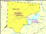
Wayne Township, Warren County, Ohio
Encyclopedia
Wayne Township is one of the eleven townships
of Warren County
, Ohio
, United States
. It is located in the northeast part of the county and includes the village of Waynesville, Ohio
. Its population in 2000
was 7,250, up from 5,744 in 1990
; 4,436 of this total lived in the unincorporated portions of the township. Waynesville is noted for its antique
stores and is the home of a sauerkraut
festival. Caesar Creek State Park
is located here.
The village of Corwin
is in the township, as are the communities of Mount Holly and Crosswick
. The Little Miami River
, which forms a portion of the township's boundary, flows through the middle of the township. The Little Miami Bike Trail
, along the route of the former Little Miami Railroad
, also passes through the township.
The portion of Wayne Township east of the Little Miami is in the Virginia Military District
and was surveyed with the metes and bounds
system, while the area west of the Little Miami was surveyed on the same plan as used in the Symmes Purchase
.
Named for General "Mad" Anthony Wayne
, it is one of twenty Wayne Townships in Ohio
.
was created from that part of Wayne lying east of Caesars Creek. On August 4, 1804, a strip two miles wide was taken from the south side and made part of the new Turtlecreek Township and on September 11, 1815, a two-mile wide strip was cut of the west side and added to the new Clearcreek Township. On October 10, 1850, Massie Township was created from parts of Wayne and Washington Townships.
The township is mainly in the Waynesville
telephone exchange, but parts are in the Spring Valley
, Bellbrook
, Lebanon
, and Centerville
exchanges.
Civil township
A civil township is a widely used unit of local government in the United States, subordinate to, and geographic divisions of, a county. Specific responsibilities and the degree of autonomy vary based on each state. Civil townships are distinct from survey townships, but in states that have both,...
of Warren County
Warren County, Ohio
Warren County is a county located in the state of Ohio, United States. The population was 212,693 at the 2010 census. Its county seat is Lebanon. Warren County was erected May 1, 1803, from Hamilton County, and named for Dr...
, Ohio
Ohio
Ohio is a Midwestern state in the United States. The 34th largest state by area in the U.S.,it is the 7th‑most populous with over 11.5 million residents, containing several major American cities and seven metropolitan areas with populations of 500,000 or more.The state's capital is Columbus...
, United States
United States
The United States of America is a federal constitutional republic comprising fifty states and a federal district...
. It is located in the northeast part of the county and includes the village of Waynesville, Ohio
Waynesville, Ohio
Waynesville is a village in Wayne Township, Warren County, Ohio, United States. As of the 2000 census, the village population was 2,558, up from 1,949 in 1990. It is named for General "Mad" Anthony Wayne. The village, located at the crossroads of U.S. Route 42 and State Route 73, is known for its...
. Its population in 2000
United States Census, 2000
The Twenty-second United States Census, known as Census 2000 and conducted by the Census Bureau, determined the resident population of the United States on April 1, 2000, to be 281,421,906, an increase of 13.2% over the 248,709,873 persons enumerated during the 1990 Census...
was 7,250, up from 5,744 in 1990
United States Census, 1990
The Twenty-first United States Census, conducted by the Census Bureau, determined the resident population of the United States to be 248,709,873, an increase of 9.8 percent over the 226,545,805 persons enumerated during the 1980 Census....
; 4,436 of this total lived in the unincorporated portions of the township. Waynesville is noted for its antique
Antiques
An antique is an old collectible item. It is collected or desirable because of its age , beauty, rarity, condition, utility, personal emotional connection, and/or other unique features...
stores and is the home of a sauerkraut
Sauerkraut
Sauerkraut , directly translated from German: "sour cabbage", is finely shredded cabbage that has been fermented by various lactic acid bacteria, including Leuconostoc, Lactobacillus, and Pediococcus. It has a long shelf-life and a distinctive sour flavor, both of which result from the lactic acid...
festival. Caesar Creek State Park
Caesar Creek State Park
Caesar Creek State Park is located in southwestern Ohio, five miles east of Waynesville, in Warren, Clinton, and Greene Counties. The park is leased by the State from the U.S. Army Corps of Engineers, who in the 1970s erected a dam on Caesars Creek to impound a lake. The total park area,...
is located here.
Geography
Located in the northeastern corner of the county, it borders the following townships:- Sugarcreek Township, Greene County - north
- Spring Valley Township, Greene CountySpring Valley Township, Greene County, OhioSpring Valley Township is one of the twelve townships of Greene County, Ohio, United States. The 2000 census found 2,489 people in the township, 1,979 of whom lived in the unincorporated portions of the township.-Geography:...
- northeast - Chester Township, Clinton CountyChester Township, Clinton County, OhioChester Township is one of the thirteen townships of Clinton County, Ohio, United States. The 2000 census found 1,771 people in the township, up from 1,200 in 1990.-Geography:Located in the northwest corner of the county, it borders the following townships:...
- east - Massie TownshipMassie Township, Warren County, OhioMassie Township, one of the eleven townships of Warren County, Ohio, Ohio, United States, is located in the northeast part of the county and the least populous of Warren County's townships. In 2000, the population was 1,061 up from 885 in 1990; of this total, 498 lived in the unincorporated...
- southeast - Washington TownshipWashington Township, Warren County, OhioWashington Township is one of the eleven townships of Warren County, Ohio, United States. Located in the east central part of the county, it is the only one of the eleven that does not contain a municipality...
- south - Turtlecreek TownshipTurtlecreek Township, Warren County, OhioTurtlecreek Township is one of the eleven townships of Warren County, Ohio, United States. It is in the central part of the county and surrounds the county seat of Lebanon. Turtlecreek is the largest township in the county, originally containing sixty-three whole and seven fractional sections. ...
- southwest - Clearcreek TownshipClearcreek Township, Warren County, OhioClearcreek Township is one of the eleven townships of Warren County, Ohio, United States, located in the north central portion of the county. It had a population of 20,974 in 2000, up from 13,344 in 1990; of this total, 8,747 lived in the unincorporated portions of the township. It was originally...
- west - Washington Township, Montgomery CountyWashington Township, Montgomery County, OhioWashington Township is one of the nine townships of Montgomery County, Ohio, United States. As of the 2010 census the population was 56,607.Washington Township and Centerville voted November 4, 2008, on whether to create a merger commission.-Geography:...
- northwest
The village of Corwin
Corwin, Ohio
Corwin is a village in Wayne Township, Warren County, Ohio, United States. The population was 256 at the 2000 census, up from 225 in 1990. It is named for Governor Thomas Corwin. The mayor of Corwin is Cheryl L...
is in the township, as are the communities of Mount Holly and Crosswick
Crosswick, Ohio
Crosswick is an unincorporated place in central Wayne Township, Warren County, Ohio, United States, located just outside of Waynesville. It was platted by James Jennings in July 1821. It is also known as Crosswicks.-References:...
. The Little Miami River
Little Miami River
The Little Miami River is a Class I tributary of the Ohio River that flows through five counties in southwestern Ohio in the United States. The Little Miami joins the Ohio River east of Cincinnati. It forms parts of the borders between Hamilton and Clermont counties and between Hamilton and Warren...
, which forms a portion of the township's boundary, flows through the middle of the township. The Little Miami Bike Trail
Little Miami Bike Trail
The Little Miami Scenic Trail, also known as the Little Miami Scenic River Trail and Little Miami Bike Trail, is a rail trail that runs though five southwestern counties in the U.S. state of Ohio. The multi-use trail sees frequent use by hikers and bicyclists, as well as the occasional horseback...
, along the route of the former Little Miami Railroad
Little Miami Railroad
The Little Miami Railroad, now defunct, was a railway of southwestern Ohio, running from the eastern side of Cincinnati to Springfield, Ohio. By merging with the Columbus and Xenia Railroad it created the first through rail route from the important manufacturing city of Cincinnati to the state...
, also passes through the township.
The portion of Wayne Township east of the Little Miami is in the Virginia Military District
Virginia Military District
The Virginia Military District was an approximately 4.2 million acre area of land in what is now the state of Ohio that was reserved by Virginia to use as payment for veterans of the American Revolutionary War....
and was surveyed with the metes and bounds
Metes and bounds
Metes and bounds is a system or method of describing land, real property or real estate. The system has been used in England for many centuries, and is still used there in the definition of general boundaries...
system, while the area west of the Little Miami was surveyed on the same plan as used in the Symmes Purchase
Symmes Purchase
The Symmes Purchase, also known as the Miami Purchase, was an area of land in Southwestern Ohio in what is now Hamilton, Butler, and Warren Counties. It was purchased by Judge John Cleves Symmes of New Jersey from the Continental Congress...
.
Named for General "Mad" Anthony Wayne
Anthony Wayne
Anthony Wayne was a United States Army general and statesman. Wayne adopted a military career at the outset of the American Revolutionary War, where his military exploits and fiery personality quickly earned him a promotion to the rank of brigadier general and the sobriquet of Mad Anthony.-Early...
, it is one of twenty Wayne Townships in Ohio
Wayne Township, Ohio
Wayne Township, Ohio may refer to:*Wayne Township, Adams County, Ohio*Wayne Township, Ashtabula County, Ohio*Wayne Township, Auglaize County, Ohio*Wayne Township, Belmont County, Ohio*Wayne Township, Butler County, Ohio...
.
History
One of the original townships of Warren County, it was created on May 10, 1803, nine days after the county was erected. The original boundaries were: "Beginning at the northeast corner of Section 33 in the third township; thence east to the northeast corner of the county; thence south to a point drawn due east from the north boundard of the third military range; thence due west to the southwest corner of Section 25, in the fourth range; thence due north to the place of beginning." When created, Warren County extended much farther to the east than today and Wayne Township encompassed a large area now in Clinton County. On June 26, 1806, Eaton TownshipEaton Township, Warren County, Ohio
Eaton Township was a township of Warren County, Ohio, United States. It was created on June 26, 1806, from the eastern part of Wayne Township beyond Caesars Creek. When Clinton County was created in 1815, most of the land became part of Clinton County....
was created from that part of Wayne lying east of Caesars Creek. On August 4, 1804, a strip two miles wide was taken from the south side and made part of the new Turtlecreek Township and on September 11, 1815, a two-mile wide strip was cut of the west side and added to the new Clearcreek Township. On October 10, 1850, Massie Township was created from parts of Wayne and Washington Townships.
Government
The township is governed by a three-member board of trustees, who are elected in November of odd-numbered years to a four-year term beginning on the following January 1. Two are elected in the year after the presidential election and one is elected in the year before it. There is also an elected township fiscal officer, who serves a four-year term beginning on April 1 of the year after the election, which is held in November of the year before the presidential election. Vacancies in the fiscal officership or on the board of trustees are filled by the remaining trustees.Public services
Most of the township is in the Wayne Local School District, but parts are in the Lebanon, Spring Valley, Clinton Massie and Xenia districts.The township is mainly in the Waynesville
Waynesville, Ohio
Waynesville is a village in Wayne Township, Warren County, Ohio, United States. As of the 2000 census, the village population was 2,558, up from 1,949 in 1990. It is named for General "Mad" Anthony Wayne. The village, located at the crossroads of U.S. Route 42 and State Route 73, is known for its...
telephone exchange, but parts are in the Spring Valley
Spring Valley, Ohio
Spring Valley is a village in Greene County, Ohio, United States. The population was 551 at the 2010 census. It is part of the Dayton Metropolitan Statistical Area.-Geography:Spring Valley is located at ....
, Bellbrook
Bellbrook, Ohio
Bellbrook is a city in Greene County, Ohio, United States. The population was 6,943 at the 2010 census. It is part of the Dayton Metropolitan Statistical Area.-History:Bellbrook was first settled in 1814...
, Lebanon
Lebanon, Ohio
The population at the 2010 census was 20,033. As of the census of 2000, there were 16,962 people residing in the city. The population density was 1,440.6 people per square mile . There were 6,218 housing units at an average density of 528.1 per square mile...
, and Centerville
Centerville, Montgomery County, Ohio
* Centerville City School District, Montgomery County, Ohio* Mad River Road* State Route 48* State Route 725-External links:* *...
exchanges.