

Water of Leith, New Zealand
Encyclopedia
The Water of Leith is a small river in the South Island
of New Zealand
.
It rises to the north of the city of Dunedin
, flowing for 14 kilometres southeast through the northern part of the city
and the campus of the University of Otago
before reaching the Otago Harbour
. The name of the city of Dunedin is the anglicised form of Dùn Èideann which is the Scottish Gaelic form of the name Edinburgh
, and thus the river is also named for the Water of Leith
which runs through the Scottish
capital. The original Māori
name for the stream was Owheo ("The place of Wheo"), Wheo being the name of a local chief whose village stood close to its mouth. This name is now rarely used.
, part of State Highway 1
, 100 metres to the south of Leith Saddle
, at a height of some 380 metres above sea level. The motorway passes over the Leith Saddle, which lies between the sources of the Leith and the Waitati River
, approximately half way between the northern suburb of Pine Hill
and the outlying settlement of Waitati
.
From here, the Leith flows initially south into a reservoir formed behind Sullivan's Dam, which was constructed in 1916. This reservoir, along with the Ross Creek Reservoir
on the Ross Creek, one of the Leith's tributaries, provide much of Dunedin's drinking water.
From the southern end of the Sullivan's Dam reservoir, the Leith flows southwest, passing under the motorway and through the wooded Leith Valley
. A gravel road parallels the course of this stretch of the river, becoming asphalted close to the point where the Leith meets the urban parts of the city at Glenleith. Several small tributaries join the Leith on this stretch, notably Morrison's Burn.
As it reaches urban Dunedin, the river is often only a modest stream, partly because of the quantity of water abstracted upstream. Much of the northern part of Dunedin's inner city area is situated on the river's floodplain.
The first of the Leith's two main tributaries, Ross Creek, joins the Leith between the suburbs of Glenleith and Woodhaugh. The Ross Creek Reservoir
, a historic engineering project, is surrounded by numerous popular bush walks. Much of the upper Leith Valley is also crossed by less well-known bush tracks, though part of the upper reaches are closed to the public due to their importance for water catchment purposes. Close to this confluence, the remains can be seen of watermills which were used at Woodhaugh, which - though now a sleepy suburb - was once the industrial heart of the city. From here, the Leith turns to the southeast, passing through a public park, Woodhaugh Gardens, as its floodplain begins to widen. At this point, the floodplain is less than a kilometre in width, and is bordered by steep cliffs to the southwest.
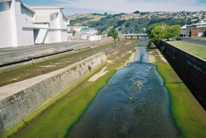
The lower reaches of the Leith are contained within concrete channels. These, and the various weirs located in the Leith's stream - notably just to the north of Woodhaugh Gardens, were built to prevent a repeat of the serious damage to Dunedin North
by the highest recorded flood in March 1929. An earlier devastating flood occurred on the river in 1868. The original course of the Leith was, in fact, a meandering track through what is now the central city, emptying into the upper harbour where Cumberland and Stuart Streets
now meet.
 The Leith enters the wider plain which is the location of Dunedin's most intensely urbanised area at the southeastern end of Woodhaugh Gardens, close to the northernmost point of the city's main street, George Street
. From here, it winds around the northern edge of the floodplain, skirting the Dunedin Botanic Gardens
, where it is joined by its other main tributary, Lindsay Creek. This small stream flows from the southern slopes of Mount Cargill
, through Bethune's Gully
and along North East Valley
before crossing the Botanic Gardens and connecting with the Leith. A bronze statue of a trout in the Botanic Gardens commemorates the first liberation into a New Zealand river of brown trout
, imported from Tasmania
in 1869.
The Leith then turns south, flowing through the heart of the University of Otago
campus at which point it veers east, passing the campus of Otago Polytechnic
and the Dunedin College of Education and then Forsyth Barr Stadium before reaching the Otago Harbour
south of Logan Park
.
South Island
The South Island is the larger of the two major islands of New Zealand, the other being the more populous North Island. It is bordered to the north by Cook Strait, to the west by the Tasman Sea, to the south and east by the Pacific Ocean...
of New Zealand
New Zealand
New Zealand is an island country in the south-western Pacific Ocean comprising two main landmasses and numerous smaller islands. The country is situated some east of Australia across the Tasman Sea, and roughly south of the Pacific island nations of New Caledonia, Fiji, and Tonga...
.
It rises to the north of the city of Dunedin
Dunedin
Dunedin is the second-largest city in the South Island of New Zealand, and the principal city of the Otago Region. It is considered to be one of the four main urban centres of New Zealand for historic, cultural, and geographic reasons. Dunedin was the largest city by territorial land area until...
, flowing for 14 kilometres southeast through the northern part of the city
Dunedin North
Dunedin North, also known as North Dunedin, is a major inner suburb of the New Zealand city of Dunedin, located to the northeast of the city centre. It contains many of the city's major institutions, including the city's university, polytechnic, main hospital, and largest museum...
and the campus of the University of Otago
University of Otago
The University of Otago in Dunedin is New Zealand's oldest university with over 22,000 students enrolled during 2010.The university has New Zealand's highest average research quality and in New Zealand is second only to the University of Auckland in the number of A rated academic researchers it...
before reaching the Otago Harbour
Otago Harbour
Otago Harbour is the natural harbour of Dunedin, New Zealand, consisting of a long, much-indented stretch of generally navigable water separating the Otago Peninsula from the mainland. They join at its southwest end, from the harbour mouth...
. The name of the city of Dunedin is the anglicised form of Dùn Èideann which is the Scottish Gaelic form of the name Edinburgh
Edinburgh
Edinburgh is the capital city of Scotland, the second largest city in Scotland, and the eighth most populous in the United Kingdom. The City of Edinburgh Council governs one of Scotland's 32 local government council areas. The council area includes urban Edinburgh and a rural area...
, and thus the river is also named for the Water of Leith
Water of Leith
The Water of Leith is the main river flowing through Edinburgh, Scotland, to the port of Leith where it flows into the sea via the Firth of Forth.It is long and rises in the Colzium Springs at Millstone Rig of the Pentland Hills...
which runs through the Scottish
Scotland
Scotland is a country that is part of the United Kingdom. Occupying the northern third of the island of Great Britain, it shares a border with England to the south and is bounded by the North Sea to the east, the Atlantic Ocean to the north and west, and the North Channel and Irish Sea to the...
capital. The original Māori
Maori language
Māori or te reo Māori , commonly te reo , is the language of the indigenous population of New Zealand, the Māori. It has the status of an official language in New Zealand...
name for the stream was Owheo ("The place of Wheo"), Wheo being the name of a local chief whose village stood close to its mouth. This name is now rarely used.
Course
The Leith's source is close to the Dunedin Northern MotorwayDunedin Northern Motorway
Dunedin-Waitati Highway , formerly called Dunedin Northern Motorway, is a two to four-lane limited-access road which provides the main route north from the city of Dunedin, New Zealand. It was constructed in the 1950s to replace narrow, winding routes via Port Chalmers and Mount Cargill...
, part of State Highway 1
State Highway 1 (New Zealand)
State Highway 1 is the longest and most significant road in the New Zealand roading network, running the length of both main islands. It appears on road maps as SH 1 and on road signs as a white number 1 on a red shield, but it has the official designations SH 1N in the North Island, SH 1S in the...
, 100 metres to the south of Leith Saddle
Leith Saddle
thumb|350px|Leith Saddle near Dunedin, New ZealandLeith Saddle is a saddle between the sources of the Water of Leith and the Waitati River, approximately half way between Dunedin's northern suburb of Pine Hill and the outlying settlement of Waitati. The saddle is a strategic point where the Dunedin...
, at a height of some 380 metres above sea level. The motorway passes over the Leith Saddle, which lies between the sources of the Leith and the Waitati River
Waitati River
The Waitati River is a river in New Zealand, flowing into the Pacific Ocean at Blueskin Bay, north of Dunedin.-References:...
, approximately half way between the northern suburb of Pine Hill
Pine Hill, New Zealand
Pine Hill is a suburb, hill, and general area of the New Zealand city of Dunedin. It is sited on the hill of the same name, a spur of Mount Cargill overlooking North East Valley and Glenleith to the north of the city centre. This spur lies in the fork of the confluence of the Water of Leith and...
and the outlying settlement of Waitati
Waitati
Waitati is a small seaside settlement in Otago, New Zealand, within the city limits of Dunedin. It is located close to the tidal mudflats of Blueskin Bay, 19 kilometres north of the Dunedin city centre...
.
From here, the Leith flows initially south into a reservoir formed behind Sullivan's Dam, which was constructed in 1916. This reservoir, along with the Ross Creek Reservoir
Ross Creek Reservoir
The Ross Creek Reservoir is an artificial lake in Dunedin, New Zealand. One of the oldest artificial lakes in the country, and the oldest water supply reservoir still in use in the country, it was created in the 1860s to provide water for the city of Dunedin, at that time in the middle of rapid...
on the Ross Creek, one of the Leith's tributaries, provide much of Dunedin's drinking water.
From the southern end of the Sullivan's Dam reservoir, the Leith flows southwest, passing under the motorway and through the wooded Leith Valley
Leith Valley
Leith Valley is a suburb, valley, and general area of the New Zealand city of Dunedin, located to the northwest of the city centre. To differentiate the name of the valley from that of the suburb, the former is usually referred to as the Leith Valley, the latter simply as Leith Valley.-The valley...
. A gravel road parallels the course of this stretch of the river, becoming asphalted close to the point where the Leith meets the urban parts of the city at Glenleith. Several small tributaries join the Leith on this stretch, notably Morrison's Burn.
As it reaches urban Dunedin, the river is often only a modest stream, partly because of the quantity of water abstracted upstream. Much of the northern part of Dunedin's inner city area is situated on the river's floodplain.
The first of the Leith's two main tributaries, Ross Creek, joins the Leith between the suburbs of Glenleith and Woodhaugh. The Ross Creek Reservoir
Ross Creek Reservoir
The Ross Creek Reservoir is an artificial lake in Dunedin, New Zealand. One of the oldest artificial lakes in the country, and the oldest water supply reservoir still in use in the country, it was created in the 1860s to provide water for the city of Dunedin, at that time in the middle of rapid...
, a historic engineering project, is surrounded by numerous popular bush walks. Much of the upper Leith Valley is also crossed by less well-known bush tracks, though part of the upper reaches are closed to the public due to their importance for water catchment purposes. Close to this confluence, the remains can be seen of watermills which were used at Woodhaugh, which - though now a sleepy suburb - was once the industrial heart of the city. From here, the Leith turns to the southeast, passing through a public park, Woodhaugh Gardens, as its floodplain begins to widen. At this point, the floodplain is less than a kilometre in width, and is bordered by steep cliffs to the southwest.
The lower reaches of the Leith are contained within concrete channels. These, and the various weirs located in the Leith's stream - notably just to the north of Woodhaugh Gardens, were built to prevent a repeat of the serious damage to Dunedin North
Dunedin North
Dunedin North, also known as North Dunedin, is a major inner suburb of the New Zealand city of Dunedin, located to the northeast of the city centre. It contains many of the city's major institutions, including the city's university, polytechnic, main hospital, and largest museum...
by the highest recorded flood in March 1929. An earlier devastating flood occurred on the river in 1868. The original course of the Leith was, in fact, a meandering track through what is now the central city, emptying into the upper harbour where Cumberland and Stuart Streets
Stuart Street, Dunedin
Stuart Street is one of the main streets of Dunedin, New Zealand. As with many of Dunedin's streets, it is named after a main street in Edinburgh, Scotland....
now meet.
George Street, Dunedin
George Street is the main street of Dunedin, the second largest city in the South Island of New Zealand. It runs for two and a half kilometres north-northeast from The Octagon in the city centre to the foot of Pine Hill. It is straight and undulates gently as it skirts the edge of the hills to its...
. From here, it winds around the northern edge of the floodplain, skirting the Dunedin Botanic Gardens
Dunedin Botanic Gardens
The Dunedin Botanical Gardens are located at the northern end of central Dunedin, in the South Island of New Zealand. They are located close to the University of Otago and one of the city's most historic cemeteries, the Northern Cemetery, on a spur of Signal Hill and on the river plain immediately...
, where it is joined by its other main tributary, Lindsay Creek. This small stream flows from the southern slopes of Mount Cargill
Mount Cargill
Mount Cargill is a 680 metre high volcanic outcrop which dominates the skyline of northern Dunedin, New Zealand. It is situated some 15 kilometres north of the city centre....
, through Bethune's Gully
Bethune's Gully
Bethune's Gully is notable geological feature of northern Dunedin, in the South Island of New Zealand. It is located close to the suburb of Normanby towards the northern end of North East Valley. It preserves a number of acres of very old-growth forest and a large stand of exotic Douglas fir, and...
and along North East Valley
North East Valley
North East Valley is a suburb of the New Zealand city of Dunedin.-Geography and demographics:...
before crossing the Botanic Gardens and connecting with the Leith. A bronze statue of a trout in the Botanic Gardens commemorates the first liberation into a New Zealand river of brown trout
Brown trout
The brown trout and the sea trout are fish of the same species....
, imported from Tasmania
Tasmania
Tasmania is an Australian island and state. It is south of the continent, separated by Bass Strait. The state includes the island of Tasmania—the 26th largest island in the world—and the surrounding islands. The state has a population of 507,626 , of whom almost half reside in the greater Hobart...
in 1869.
The Leith then turns south, flowing through the heart of the University of Otago
University of Otago
The University of Otago in Dunedin is New Zealand's oldest university with over 22,000 students enrolled during 2010.The university has New Zealand's highest average research quality and in New Zealand is second only to the University of Auckland in the number of A rated academic researchers it...
campus at which point it veers east, passing the campus of Otago Polytechnic
Otago Polytechnic
The Otago Polytechnic is a public New Zealand tertiary education institute, centred in Dunedin with campuses throughout the region of Otago including Cromwell, Wanaka and Queenstown....
and the Dunedin College of Education and then Forsyth Barr Stadium before reaching the Otago Harbour
Otago Harbour
Otago Harbour is the natural harbour of Dunedin, New Zealand, consisting of a long, much-indented stretch of generally navigable water separating the Otago Peninsula from the mainland. They join at its southwest end, from the harbour mouth...
south of Logan Park
Logan Park, Dunedin
Logan Park is a sporting venue in the city of Dunedin, New Zealand. It lies on land reclaimed from the former Lake Logan.- History :Lake Logan was reclaimed in the early 20th century...
.