

North East Valley
Encyclopedia
North East Valley is a suburb of the New Zealand
city of Dunedin
.
, a tributary of the Water of Leith
and on the flanking slopes of Pine Hill
and Signal Hill
, 3 kilometres (1.9 mi) to the northeast of the city centre.
North East Valley is a residential suburb, and is home to a mix of older residents and students from the city's tertiary institutions (the University of Otago
and Otago Polytechnic
, which lie 1 kilometre (0.621372736649807 mi) to the south, beyond the Dunedin Botanic Gardens. The suburb mainly consists of one long street, North Road, and numerous largely parallel side roads which branch off it, many of which - especially on the eastern (Signal Hill) side - are notoriously steep. One of these, Baldwin Street
, is reputedly the world's steepest street. Other than North Road, the suburb's main roads include Blacks Road and Norwood Street.
North East Valley was a separate borough until 1910, when it was amalgamated with the city of Dunedin.
).
Normanby is the name of the northern end of North East Valley, at which point Dunedin's urban area gives way to open countryside. The land here is steeply sloping, as it is the foothills of Mount Cargill
. The slopes of Mount Cargill itself are densely wooded, and are crisscrossed with walking tracks, some of which start at the Bethune's Gully
reserve, at the northern end of Normanby. Mount Mera is an area of state housing
sitting on the north facing side of the valley, just above Normanby.
Road and Bank Street (which links with the northern end of Dunedin's main street, George Street
). A sports ground at this corner (the Gardens Ground) is the site of cricket and football pitches, and beyond this ground is the southern end of the Dunedin Northern Motorway
, part of State Highway 1
. The Gardens Ground is the home ground of Northern Football Club
and North East Valley Cricket Club.
From the Gardens Corner, North Road runs relatively straight for 2 kilometres (1.2 mi), crossing the Lindsay Creek and continuing to the northeast. Blacks Road, a steep connection to the suburb of Opoho
, branches off North Road close to the valley's widest point. Past Chingford Park, the suburban part of the road ends at the junction with Norwood Street, and North Road starts to climb and wind around the end of the valley. From here, it runs through rural farmland, connecting with roads to Port Chalmers
and Waitati
. Until the construction of the Dunedin Northern Motorway
this was a major route out of Dunedin to the north, but is now only lightly used.
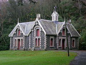 Apart from Baldwin Street, North East Valley has several noted landmarks. Two university halls of residence, Knox College
and Salmond College lie on the lower slopes to the east of the Gardens Corner, and another, Aquinas College lies on the lower slopes of Pine Hill immediately to the west. Close to this stands another prominent building, the former Santa Sabina Convent, which is visible from much of the northern central city. Another prominent building in the valley is Ross Home, one of the city's major retirement homes, which is located in North Road.
The suburb has several notable parks and gardens, among them Chingford Park, the Quarry Gardens, Forrester Park, and Bethune's Gully.
Chingford Park is a recreational reserve containing historic stone stables, located towards the northern end of North Road. It surrounded the no-longer extant Chingford House, which had been built in 1862. The property was built and landscaped in the 1870s and 1880s by businessman P.C. Neill (one of whose descendants is actor Sam Neill
). Among improvements made by Neill to the property include the historic bluestone
stables, built in 1880, which still stand as a centre for the park. Chingford Park is popular with walkers, and also contains soccer and cricket grounds, and the city's main archery club.Other notable features of the Park include several giant Macrocarpa trees which stand close to the banks of Lindsay Creek.
The Quarry Gardens are a park created from the former Palmer's Quarry, and is located on North Road directly opposite the bottom of Baldwin Street. The quarry was closed in 1980, and was thoroughly landscaped from 1989 into a terraced garden area. The amphitheatre of the old quarry pit has been used as an outdoor music venue, though it has not been used in this capacity for about a decade several walking tracks climb to the terraces of the former quarry, which have been extensively planted with many species, notably rhododendrons, and other walking paths follow the banks of the Lindsay Creek, connecting with Selwyn Street to the south and Watts road to the north. The gardens are privately owned, but are open to the public year-round.
Forrester Park is a sports ground at the end of Norwood Street. It contains football and rugby pitches and the city's BMX circuit and dog park and kennel club. Bethune's Gully is also accessed from Norwood Street. It is a secluded 86 hectares (212.5 acre) reserve which lies at the southernmost foothills of Mount Cargill
, and is a popular scenic area. From here, walking tracks ascend the slopes of Cargill. The reserve was originally the site of sawmills and brick kilns operated by David Bethune in the 1880s, and became city council property in 1955.
New Zealand
New Zealand is an island country in the south-western Pacific Ocean comprising two main landmasses and numerous smaller islands. The country is situated some east of Australia across the Tasman Sea, and roughly south of the Pacific island nations of New Caledonia, Fiji, and Tonga...
city of Dunedin
Dunedin
Dunedin is the second-largest city in the South Island of New Zealand, and the principal city of the Otago Region. It is considered to be one of the four main urban centres of New Zealand for historic, cultural, and geographic reasons. Dunedin was the largest city by territorial land area until...
.
Geography and demographics
North East Valley sits in the valley of the Lindsay CreekLindsay Creek
The Lindsay Creek is a tributary of the Water of Leith which runs through the northern suburbs of Dunedin, New Zealand. The Māori name for the creek, now rarely used, is Puke-haukea....
, a tributary of the Water of Leith
Water of Leith, New Zealand
The Water of Leith , is a small river in the South Island of New Zealand.It rises to the north of the city of Dunedin, flowing for 14 kilometres southeast through the northern part of the city and the campus of the University of Otago before reaching the Otago Harbour...
and on the flanking slopes of Pine Hill
Pine Hill, New Zealand
Pine Hill is a suburb, hill, and general area of the New Zealand city of Dunedin. It is sited on the hill of the same name, a spur of Mount Cargill overlooking North East Valley and Glenleith to the north of the city centre. This spur lies in the fork of the confluence of the Water of Leith and...
and Signal Hill
Signal Hill, New Zealand
Signal Hill is a prominent landform in the city of Dunedin, New Zealand. It is located close to, and due north of, the head of the Otago Harbour and reaches an elevation of 393 m . The suburbs Ravensbourne, St. Leonards, and Opoho lie on its southern, eastern, and northwestern flanks, respectively...
, 3 kilometres (1.9 mi) to the northeast of the city centre.
North East Valley is a residential suburb, and is home to a mix of older residents and students from the city's tertiary institutions (the University of Otago
University of Otago
The University of Otago in Dunedin is New Zealand's oldest university with over 22,000 students enrolled during 2010.The university has New Zealand's highest average research quality and in New Zealand is second only to the University of Auckland in the number of A rated academic researchers it...
and Otago Polytechnic
Otago Polytechnic
The Otago Polytechnic is a public New Zealand tertiary education institute, centred in Dunedin with campuses throughout the region of Otago including Cromwell, Wanaka and Queenstown....
, which lie 1 kilometre (0.621372736649807 mi) to the south, beyond the Dunedin Botanic Gardens. The suburb mainly consists of one long street, North Road, and numerous largely parallel side roads which branch off it, many of which - especially on the eastern (Signal Hill) side - are notoriously steep. One of these, Baldwin Street
Baldwin Street, Dunedin
Baldwin Street in a suburban part of New Zealand's southern city of Dunedin, is considered the world's steepest residential street. It is located in the suburb of North East Valley, northeast of Dunedin's city centre....
, is reputedly the world's steepest street. Other than North Road, the suburb's main roads include Blacks Road and Norwood Street.
North East Valley was a separate borough until 1910, when it was amalgamated with the city of Dunedin.
The Gardens, Normanby, and Mount Mera
The term North East Valley is often used to encompass four smaller suburbs within the valley, but more specifically refers to only one, which stretches from approximately Chambers Street north to Chingford Park. Beyond this are two smaller residential areas, Normanby and Mount Mera, and the area below Chambers Street is often simply referred to as The Gardens or The Gardens Corner (after the nearby Dunedin Botanic GardensDunedin Botanic Gardens
The Dunedin Botanical Gardens are located at the northern end of central Dunedin, in the South Island of New Zealand. They are located close to the University of Otago and one of the city's most historic cemeteries, the Northern Cemetery, on a spur of Signal Hill and on the river plain immediately...
).
Normanby is the name of the northern end of North East Valley, at which point Dunedin's urban area gives way to open countryside. The land here is steeply sloping, as it is the foothills of Mount Cargill
Mount Cargill
Mount Cargill is a 680 metre high volcanic outcrop which dominates the skyline of northern Dunedin, New Zealand. It is situated some 15 kilometres north of the city centre....
. The slopes of Mount Cargill itself are densely wooded, and are crisscrossed with walking tracks, some of which start at the Bethune's Gully
Bethune's Gully
Bethune's Gully is notable geological feature of northern Dunedin, in the South Island of New Zealand. It is located close to the suburb of Normanby towards the northern end of North East Valley. It preserves a number of acres of very old-growth forest and a large stand of exotic Douglas fir, and...
reserve, at the northern end of Normanby. Mount Mera is an area of state housing
State housing
State housing is the system of public housing offered to New Zealand residents on low to moderate incomes. Some 66,000 houses are managed by Housing New Zealand Corporation, most of which are owned by the government.-The Liberal Government:...
sitting on the north facing side of the valley, just above Normanby.
North Road
North Road, originally the main road north out of Dunedin, starts at the Gardens Corner, where it links with OpohoOpoho
Opoho is a suburb of the New Zealand city of Dunedin. It sits on the western flank of Signal Hill, New Zealand, to the northeast of the city centre, overlooking North East Valley and the Dunedin Botanic Gardens....
Road and Bank Street (which links with the northern end of Dunedin's main street, George Street
George Street, Dunedin
George Street is the main street of Dunedin, the second largest city in the South Island of New Zealand. It runs for two and a half kilometres north-northeast from The Octagon in the city centre to the foot of Pine Hill. It is straight and undulates gently as it skirts the edge of the hills to its...
). A sports ground at this corner (the Gardens Ground) is the site of cricket and football pitches, and beyond this ground is the southern end of the Dunedin Northern Motorway
Dunedin Northern Motorway
Dunedin-Waitati Highway , formerly called Dunedin Northern Motorway, is a two to four-lane limited-access road which provides the main route north from the city of Dunedin, New Zealand. It was constructed in the 1950s to replace narrow, winding routes via Port Chalmers and Mount Cargill...
, part of State Highway 1
State Highway 1 (New Zealand)
State Highway 1 is the longest and most significant road in the New Zealand roading network, running the length of both main islands. It appears on road maps as SH 1 and on road signs as a white number 1 on a red shield, but it has the official designations SH 1N in the North Island, SH 1S in the...
. The Gardens Ground is the home ground of Northern Football Club
Northern (soccer)
Northern AFC is a semi-professional association football club in North East Valley, Dunedin, New Zealand. They are currently competing in the ODT FootballSouth Premier League.The club is based at The Gardens Ground, North East Valley, Dunedin....
and North East Valley Cricket Club.
From the Gardens Corner, North Road runs relatively straight for 2 kilometres (1.2 mi), crossing the Lindsay Creek and continuing to the northeast. Blacks Road, a steep connection to the suburb of Opoho
Opoho
Opoho is a suburb of the New Zealand city of Dunedin. It sits on the western flank of Signal Hill, New Zealand, to the northeast of the city centre, overlooking North East Valley and the Dunedin Botanic Gardens....
, branches off North Road close to the valley's widest point. Past Chingford Park, the suburban part of the road ends at the junction with Norwood Street, and North Road starts to climb and wind around the end of the valley. From here, it runs through rural farmland, connecting with roads to Port Chalmers
Port Chalmers
Port Chalmers is a suburb and the main port of the city of Dunedin, New Zealand, with a population of 3,000. Port Chalmers lies ten kilometres inside Otago Harbour, some 15 kilometres northeast from Dunedin's city centre....
and Waitati
Waitati
Waitati is a small seaside settlement in Otago, New Zealand, within the city limits of Dunedin. It is located close to the tidal mudflats of Blueskin Bay, 19 kilometres north of the Dunedin city centre...
. Until the construction of the Dunedin Northern Motorway
Dunedin Northern Motorway
Dunedin-Waitati Highway , formerly called Dunedin Northern Motorway, is a two to four-lane limited-access road which provides the main route north from the city of Dunedin, New Zealand. It was constructed in the 1950s to replace narrow, winding routes via Port Chalmers and Mount Cargill...
this was a major route out of Dunedin to the north, but is now only lightly used.
Landmarks
Knox College, Otago
Knox College is a privately run residential college affiliated to the University of Otago in New Zealand, providing accommodation for primarily first and second year students, with a smaller number of postgraduates. The college is set in an landscaped site in Opoho on the opposite side of the...
and Salmond College lie on the lower slopes to the east of the Gardens Corner, and another, Aquinas College lies on the lower slopes of Pine Hill immediately to the west. Close to this stands another prominent building, the former Santa Sabina Convent, which is visible from much of the northern central city. Another prominent building in the valley is Ross Home, one of the city's major retirement homes, which is located in North Road.
The suburb has several notable parks and gardens, among them Chingford Park, the Quarry Gardens, Forrester Park, and Bethune's Gully.
Chingford Park is a recreational reserve containing historic stone stables, located towards the northern end of North Road. It surrounded the no-longer extant Chingford House, which had been built in 1862. The property was built and landscaped in the 1870s and 1880s by businessman P.C. Neill (one of whose descendants is actor Sam Neill
Sam Neill
Nigel John Dermot "Sam" Neill, DCNZM, OBE is a New Zealand actor. He is well known for his starring role as paleontologist Dr Alan Grant in Jurassic Park and Jurassic Park III....
). Among improvements made by Neill to the property include the historic bluestone
Bluestone
Bluestone is a cultural or commercial name for a number of dimension or building stone varieties, including:*a feldspathic sandstone in the U.S. and Canada;*limestone in the Shenandoah Valley in the U.S...
stables, built in 1880, which still stand as a centre for the park. Chingford Park is popular with walkers, and also contains soccer and cricket grounds, and the city's main archery club.Other notable features of the Park include several giant Macrocarpa trees which stand close to the banks of Lindsay Creek.
The Quarry Gardens are a park created from the former Palmer's Quarry, and is located on North Road directly opposite the bottom of Baldwin Street. The quarry was closed in 1980, and was thoroughly landscaped from 1989 into a terraced garden area. The amphitheatre of the old quarry pit has been used as an outdoor music venue, though it has not been used in this capacity for about a decade several walking tracks climb to the terraces of the former quarry, which have been extensively planted with many species, notably rhododendrons, and other walking paths follow the banks of the Lindsay Creek, connecting with Selwyn Street to the south and Watts road to the north. The gardens are privately owned, but are open to the public year-round.
Forrester Park is a sports ground at the end of Norwood Street. It contains football and rugby pitches and the city's BMX circuit and dog park and kennel club. Bethune's Gully is also accessed from Norwood Street. It is a secluded 86 hectares (212.5 acre) reserve which lies at the southernmost foothills of Mount Cargill
Mount Cargill
Mount Cargill is a 680 metre high volcanic outcrop which dominates the skyline of northern Dunedin, New Zealand. It is situated some 15 kilometres north of the city centre....
, and is a popular scenic area. From here, walking tracks ascend the slopes of Cargill. The reserve was originally the site of sawmills and brick kilns operated by David Bethune in the 1880s, and became city council property in 1955.