

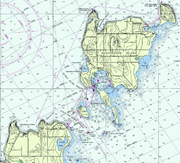
Washington Island (Wisconsin)
Encyclopedia
Door Peninsula
The Door Peninsula is a peninsula in eastern Wisconsin, separating the southern part of the Green Bay from Lake Michigan. The peninsula begins in northern Brown and Kewaunee counties and proceeds northeast to include all of Door County. It is the western portion of the Niagara Escarpment. Well...
in Door County
Door County, Wisconsin
Door County is a county in the U.S. state of Wisconsin. As of 2000, the population was 27,961. Its county seat is Sturgeon Bay. Door County is a popular vacation and tourist destination, especially for residents of Wisconsin and Illinois....
, Wisconsin
Wisconsin
Wisconsin is a U.S. state located in the north-central United States and is part of the Midwest. It is bordered by Minnesota to the west, Iowa to the southwest, Illinois to the south, Lake Michigan to the east, Michigan to the northeast, and Lake Superior to the north. Wisconsin's capital is...
. The island has a year-round population of 660 people (2000 census
United States Census, 2000
The Twenty-second United States Census, known as Census 2000 and conducted by the Census Bureau, determined the resident population of the United States on April 1, 2000, to be 281,421,906, an increase of 13.2% over the 248,709,873 persons enumerated during the 1990 Census...
). It has a land area of 60.89 km² (23.51 sq mi) and comprises over 92 percent of the land area of the town of Washington
Washington, Door County, Wisconsin
Washington is a town in northern Door County, Wisconsin, United States, with a population of 660 at the 2000 census. The unincorporated communities of Detroit Harbor and Washington are located in the town....
, as well as all of its population. The unincorporated community of Detroit Harbor
Detroit Harbor, Wisconsin
Detroit Harbor is an unincorporated community located in the town of Washington on Washington Island in Door County, Wisconsin. The Washington Island Ferry runs scheduled passenger service to Northport from Detroit Harbor. Detroit Harbor is also home to a United States Post Office and Coast Guard...
is located on the island. It is the largest in a group of islands that includes Plum
Plum Island (Wisconsin)
Plum Island is an island at the western shore of Lake Michigan in the southern part of the town of Washington in Door County, Wisconsin, USA. The uninhabited island has a land area of 1.179 km² or 117.87 ha . The island is a bird sanctuary under control of the U.S. Coast Guard and will eventually...
, Detroit, Hog
Hog Island (Wisconsin)
Hog Island is a bird sanctuary located off the eastern shore of Washington Island in Door County, Wisconsin. There are no residents on the island, which has a land area of . It is located in the Town of Washington. Since 1913, this sanctuary has served as a habitat for many different types of...
, Pilot, and Rock Islands
Rock Island (Wisconsin)
Rock Island is a wooded island off the tip of Wisconsin's Door Peninsula at the mouth of Green Bay. The uninhabited island is almost entirely owned by the Wisconsin DNR, which maintains Rock Island State Park. It is the northernmost part of the Town of Washington.-History:Rock Island was...
. These islands form the Town of Washington
Washington, Door County, Wisconsin
Washington is a town in northern Door County, Wisconsin, United States, with a population of 660 at the 2000 census. The unincorporated communities of Detroit Harbor and Washington are located in the town....
. A large part of Washington Island's economy
Economy
An economy consists of the economic system of a country or other area; the labor, capital and land resources; and the manufacturing, trade, distribution, and consumption of goods and services of that area...
is based on tourism
Tourism
Tourism is travel for recreational, leisure or business purposes. The World Tourism Organization defines tourists as people "traveling to and staying in places outside their usual environment for not more than one consecutive year for leisure, business and other purposes".Tourism has become a...
.
Washington Island is approximately 5 miles wide by 6 miles long. Together with the Door Peninsula, Washington Island forms a treacherous strait
Strait
A strait or straits is a narrow, typically navigable channel of water that connects two larger, navigable bodies of water. It most commonly refers to a channel of water that lies between two land masses, but it may also refer to a navigable channel through a body of water that is otherwise not...
that connects Green Bay to the rest of Lake Michigan
Lake Michigan
Lake Michigan is one of the five Great Lakes of North America and the only one located entirely within the United States. It is the second largest of the Great Lakes by volume and the third largest by surface area, after Lake Superior and Lake Huron...
. Early French explorers named this water way, now littered with shipwreck
Shipwreck
A shipwreck is what remains of a ship that has wrecked, either sunk or beached. Whatever the cause, a sunken ship or a wrecked ship is a physical example of the event: this explains why the two concepts are often overlapping in English....
s, Porte des Morts
Porte des Morts
Porte des Morts, also known as Porte des Mortes, the Door of Death, and Death's Door is a strait linking Lake Michigan and Green Bay between the northern tip of the peninsula of Door County, Wisconsin and a group of islands historically known as the Potawatomi Islands and dominated by Washington...
, which means "Death's Door" and gives Door County and Door Peninsula
Door Peninsula
The Door Peninsula is a peninsula in eastern Wisconsin, separating the southern part of the Green Bay from Lake Michigan. The peninsula begins in northern Brown and Kewaunee counties and proceeds northeast to include all of Door County. It is the western portion of the Niagara Escarpment. Well...
their names.
History
Washington Island is one of a string of islands (which are an outcropping of the Niagara EscarpmentNiagara Escarpment
The Niagara Escarpment is a long escarpment, or cuesta, in the United States and Canada that runs westward from New York State, through Ontario, Michigan, Wisconsin and Illinois...
) stretching across the entrance of Green Bay from the Door Peninsula in Wisconsin to the Garden Peninsula
Garden Peninsula
The Garden Peninsula is a peninsula of in length that extends southwestward into Lake Michigan from the mainland of Michigan's Upper Peninsula. The peninsula is bordered by Lake Michigan on the east, and by Big Bay de Noc on the west. The base of the peninsula is served by U.S. Highway 2, and...
in Michigan
Michigan
Michigan is a U.S. state located in the Great Lakes Region of the United States of America. The name Michigan is the French form of the Ojibwa word mishigamaa, meaning "large water" or "large lake"....
. Its earliest known name is Wassekiganeso, an Ojibwa
Ojibwa
The Ojibwe or Chippewa are among the largest groups of Native Americans–First Nations north of Mexico. They are divided between Canada and the United States. In Canada, they are the third-largest population among First Nations, surpassed only by Cree and Inuit...
name that translates to "his breast is shining" and apparently refers to the glint of the sun that at times reflects off the limestone
Limestone
Limestone is a sedimentary rock composed largely of the minerals calcite and aragonite, which are different crystal forms of calcium carbonate . Many limestones are composed from skeletal fragments of marine organisms such as coral or foraminifera....
cliffs.
The earliest records and maps of the French, with whom written history of the region begins, do not name the individual islands, but refer to them all as a group. The names chosen depended on which group of Native Americans they found on the islands at the time. The most common name from after 1650 to 1816 was the Potawatomi Islands
Potawatomi Islands
The Potawatomi Islands is the most common historic name given to the string of islands that delineate the transition from Green Bay to Lake Michigan, one of the Great Lakes. The largest of these is Washington Island, in Door County, Wisconsin. Others include Plum Island, Detroit Island, Hog Island,...
(various spellings exist). The Potawatomi
Potawatomi
The Potawatomi are a Native American people of the upper Mississippi River region. They traditionally speak the Potawatomi language, a member of the Algonquian family. In the Potawatomi language, they generally call themselves Bodéwadmi, a name that means "keepers of the fire" and that was applied...
appear to have first come to especially the southern islands in the string about 1641 (at which time they may figure into the naming of Porte des Morts
Porte des Morts
Porte des Morts, also known as Porte des Mortes, the Door of Death, and Death's Door is a strait linking Lake Michigan and Green Bay between the northern tip of the peninsula of Door County, Wisconsin and a group of islands historically known as the Potawatomi Islands and dominated by Washington...
), then left the area for a while, and then returned again and remained there for a considerable length of time. The French form of this name (also variously spelled) is l'Isle des Poux, based on a shortened form of the tribe's name. This shortened form also appears as "Pous" and is at times erroneously confused with Puans, which refers to the Winnebago
Ho-Chunk
The Ho-Chunk, also known as Winnebago, are a tribe of Native Americans, native to what is now Wisconsin and Illinois. There are two federally recognized Ho-Chunk tribes, the Ho-Chunk Nation of Wisconsin and Winnebago Tribe of Nebraska....
. At times the French used the latter portion of the tribe's name, "Pou_a louse", resulting in Louse Islands.
Before 1800, however, a few other names were applied to these islands. The Jesuit Records of 1670-1672 refer to them as the Huron Islands. Other records of the time refer to them as the Noquet Islands, named for the small band of Ojibwa that lived in the area of what is now called Big Bay de Noc
Big Bay de Noc
Big Bay de Noc is a bay in the Upper Peninsula of the U.S. state of Michigan. The bay, which opens into Lake Michigan's Green Bay, is enclosed by Delta County...
, as well as, for a time, on Washington Island. Jonathan Carver, who traveled the area in the late 18th century, called them, simply, the Islands of the Grand Traverse.
In July, 1816, Col. John Miller was in charge of garrisoning a new fort at the head of Green Bay to be called Fort Howard. A small fleet of three schooners and one sloop
Sloop
A sloop is a sail boat with a fore-and-aft rig and a single mast farther forward than the mast of a cutter....
sailed from Mackinac
Mackinac
-Geography:* Mackinaw River, a tributary of the Illinois River* Straits of Mackinac, connecting the lakes and separates the Upper and Lower Peninsulas of Michigan* Mackinac Island, an island in the straits...
. They were the sloop Amelia and the schooners Wayne, Mink, and Washington; the last being the largest and flagship of the fleet as well as, reportedly, the largest vessel on the lakes at the time. The fleet was separated en route, and the Washington anchored in what is now Washington Harbor to wait for the others. With two days of waiting, some of the crew did some exploring on the island, and the officers, assuming theirs was the first ship to anchor there, named the harbor after the ship and in honor of President Washington
George Washington
George Washington was the dominant military and political leader of the new United States of America from 1775 to 1799. He led the American victory over Great Britain in the American Revolutionary War as commander-in-chief of the Continental Army from 1775 to 1783, and presided over the writing of...
, who had only recently died. They also began naming the various islands in the area after significant members of their party, with the name of Col. John Miller being honored on the largest island as Millers Island. Other members of the party included Maj. Talbot Chambers, John O'Fallon, and Joseph Kean. Chambers Island retains its name today, while Keans Island and Fallons Island are now called Rock and Detroit Islands, respectively.
Not every map maker or journalist, however, knew of or paid attention to this. The names of Potawatomi and Louse continued to be used by many for many years (with a continued variety of spellings). At times Potawatomi was applied to the main island; sometimes to what is now Rock Island. At times the main island is totally missing from the map. When the lighthouse was built on Rock Island, it was called Potawatomi Light, a name it retains to this day. While a few maps did chart either [?]ellens or Mellens Island (a possible corruption of Miller), the settlement of the island began with the fishers and craftsmen living around Washington Harbor. These commonly called the whole island by the name of their harbor and in the census of 1850, "Washington Island" appears. After that, both Potawatomi Islands
Potawatomi Islands
The Potawatomi Islands is the most common historic name given to the string of islands that delineate the transition from Green Bay to Lake Michigan, one of the Great Lakes. The largest of these is Washington Island, in Door County, Wisconsin. Others include Plum Island, Detroit Island, Hog Island,...
, and Potawatomi Island soon fell out of use.
Most of the people who settled on the island were Scandinavian immigrants, especially Iceland
Iceland
Iceland , described as the Republic of Iceland, is a Nordic and European island country in the North Atlantic Ocean, on the Mid-Atlantic Ridge. Iceland also refers to the main island of the country, which contains almost all the population and almost all the land area. The country has a population...
ers. Today, Washington Island is one of the oldest Icelandic communities in the United States
United States
The United States of America is a federal constitutional republic comprising fifty states and a federal district...
and among the largest outside Iceland itself.
Transportation
Two ferry routes exist to get to Washington Island. One route is to take a 30-minute ferryFerry
A ferry is a form of transportation, usually a boat, but sometimes a ship, used to carry primarily passengers, and sometimes vehicles and cargo as well, across a body of water. Most ferries operate on regular, frequent, return services...
ride from the Door Peninsula to Detroit Harbor
Detroit Harbor, Wisconsin
Detroit Harbor is an unincorporated community located in the town of Washington on Washington Island in Door County, Wisconsin. The Washington Island Ferry runs scheduled passenger service to Northport from Detroit Harbor. Detroit Harbor is also home to a United States Post Office and Coast Guard...
on the island from a freight, automotive and passenger ferry that departs daily from the Northport Pier at the northern terminus of Wisconsin Highway 42. A passenger-only ferry departing from the unincorporated community of Gills Rock
Gills Rock, Wisconsin
Gills Rock is an unincorporated community located on Highway 42 at the northern tip of the Door Peninsula in Door County, Wisconsin, United States...
on a 20-minute route that features either a ferry ride only or one that includes a narrated train tours upon arriving on Washington Island.
The Washington Island Airport
Washington Island Airport
Washington Island Airport is a public, general aviation airport located in the Town of Washington in Door County, Wisconsin.-Facilities:Washington Island Airport covers and has two runways:...
, a small public airport with two grass runways, is also located on the island.
See also
- Washington, Door County, WisconsinWashington, Door County, WisconsinWashington is a town in northern Door County, Wisconsin, United States, with a population of 660 at the 2000 census. The unincorporated communities of Detroit Harbor and Washington are located in the town....
- Wisconsin Tourism
- Islands of the MidwestIslands of the MidwestThis is a partial list of islands of the Midwestern United States. -Illinois:*Bardwell Island*Campbell's Island*Chouteau Island*Dillon Island*Gabaret Island*Goose Island...
- List of islands of the United States
- French IslandFrench Island, WisconsinFrench Island is a census-designated place in La Crosse County, Wisconsin, United States. The population was 4,207 at the 2010 census. It lies on an island of a similar name, with which it is not coextensive; most of the island is part of the city of La Crosse, but all are part of the La Crosse...
and Madeline IslandMadeline IslandMadeline Island is an island of the U.S. state of Wisconsin located in Lake Superior approximately two miles northeast of Bayfield, Wisconsin, and connected to that town seasonally by a 20 minute ferry ride or an ice road. It is the largest of the Apostle Islands, although it is not included...
, other populated islands in Wisconsin
External links
- WashingtonIsland.com
- Door County Chamber of Commerce
- Washington Island Ferry Line Departing from Northport Pier
- The Island Clipper Departing from Gills Rock
- Washington Island Airport Information