
Warner Mountains
Encyclopedia
The Warner Mountains are an 85-mile-long mountain range
running north-south through northeastern California
and extending into southern Oregon
in the United States
. The range lies within the northwestern corner of the Basin and Range Province, extending from the northeastern corner of Lassen County, California
, through eastern Modoc County, California
, (east of Alturas
), and northward into Lake County, Oregon
, (east of Lakeview
).
The highest peak in the range is Eagle Peak
with an elevation of 9892 feet (3,015.1 m). The range is part of the Modoc National Forest
in California and Fremont National Forest
in Oregon. The southern portion of the range includes Eagle Peak, within the South Warner Wilderness
.
, but part of the Great Basin
Ranges. It is in the semi-arid, sparsely-populated northeastern corner of California and the southeastern corner of Oregon. The range is a classic example of horst and graben
(fault block) topography with pluvial (ephemeral) lakes
occupying the graben basins.
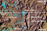
The eastern escarpment of the range overlooks the Surprise Valley in California and Warner Valley
in Oregon, enclosed basins that contain Upper Alkali Lake, Middle Alkali Lake, and Lower Alkali Lake along the California-Nevada
border, and the Warner Lakes
(Crump and Hart lakes) in Oregon. The western side of the range overlooks a ranching and farming region drained by the forks of the Pit River
, a tributary of the Sacramento River
. Goose Lake
is a 28-mile-long closed-basin lake located in the Goose Lake Valley
along the west side of the range, straddling the California-Oregon border. Goose Lake drained into the Pit River only twice in recorded history: in 1868 and 1881. The lake dried up in 1926 and 1929-34.
in the Warner Mountains was on the Lassen-Applegate Trail
used by emigrants from 1846–1850 as an alternate route to the Willamette Valley
in Oregon and the gold fields of California
. After reaching Goose Lake, the emigrant trains often split, with some continuing to the Willamette Valley and others continuing to the gold fields.
A gold-mining rush
occurred in the Warner Mountains in 1912. A number of mines were developed briefly in what was known as the High Grade Mining District just adjacent to the Oregon border in Modoc County, California.
Great quantities of lumber were removed from the Warner Mountains beginning as early as 1920. Ponderosa Pine
logs were used to supply active sawmills and box factories at Lakeview, Oregon; Alturas, California and Willow Ranch, California
. The sawmill and box factory at Willow Ranch near the Oregon-California border was a company town
with a population over 1,000 during the 1930s and 1940s. The operation closed in 1958.
on September 26, 1849, while exploring a route for potential railroad crossings of the Sierra Nevada. His remains were never found and his name appeared on maps of the range in 1866.
Camp Warner
was established in the northern portion of the Warner Range in Oregon in 1867 by General George Crook
to "pacify" the Indians. The post was abandoned in 1874. Crook Peak (elevation 7834 feet) in the Warner Range near the location of Camp Warner is named after Crook.
Mountain range
A mountain range is a single, large mass consisting of a succession of mountains or narrowly spaced mountain ridges, with or without peaks, closely related in position, direction, formation, and age; a component part of a mountain system or of a mountain chain...
running north-south through northeastern California
California
California is a state located on the West Coast of the United States. It is by far the most populous U.S. state, and the third-largest by land area...
and extending into southern Oregon
Oregon
Oregon is a state in the Pacific Northwest region of the United States. It is located on the Pacific coast, with Washington to the north, California to the south, Nevada on the southeast and Idaho to the east. The Columbia and Snake rivers delineate much of Oregon's northern and eastern...
in the United States
Northwestern United States
The Northwestern United States comprise the northwestern states up to the western Great Plains regions of the United States, and consistently include the states of Oregon, Washington, Idaho, Montana, Wyoming, to which part of southeast Alaska is also sometimes included...
. The range lies within the northwestern corner of the Basin and Range Province, extending from the northeastern corner of Lassen County, California
Lassen County, California
Lassen County is a county located in the northeastern portion of the U.S. state of California. As of the 2010 census, the population was 34,895, up from 33,828 at the 2000 census...
, through eastern Modoc County, California
Modoc County, California
Modoc County is a county located in the far northeast corner of the U.S. state of California, bounded by the state of Oregon to the north and the state of Nevada to the east. As of the 2010 census, its population was 9,686, up from 9,449 at the 2000 census. The current county seat is Alturas, the...
, (east of Alturas
Alturas, California
Alturas is the county seat of Modoc County, California, United States. Alturas is located on the Pit River, east of the center of Modoc County, at an elevation of 4370 feet...
), and northward into Lake County, Oregon
Lake County, Oregon
Lake County is a county in the high desert south central region of the U.S. state of Oregon, so named for the many lakes found within its boundaries, including Lake Abert, Hart Lake Reservoir, and Goose Lake. While Lake is among Oregon's largest counties, it is sparsely populated with 7,895...
, (east of Lakeview
Lakeview, Oregon
Lakeview is a city in Lake County, Oregon, United States. The population was 2,294 at the 2010 census. It is the county seat of Lake County. Although it is an incorporated city, the municipal government refers to the community as "The Town of Lakeview", and bills itself as "Tallest Town in Oregon"...
).
The highest peak in the range is Eagle Peak
Eagle Peak (California)
Eagle Peak is located in the Warner Mountains in Modoc County, California. The area is protected in the South Warner Wilderness on the Modoc National Forest. The summit is the highest point in the Warner Mountains and Modoc County...
with an elevation of 9892 feet (3,015.1 m). The range is part of the Modoc National Forest
Modoc National Forest
Modoc National Forest is a national forest in northeastern California, covering parts of Modoc , Lassen , and Siskiyou counties. Most of the forest was covered by an immense lava flow millions of years ago. The eastern part of the forest east of Alturas contains a spur of the Cascade Range to...
in California and Fremont National Forest
Fremont-Winema National Forests
The Fremont–Winema National Forests are two United States National Forests, Fremont National Forest and Winema National Forest, that were administratively combined in 2002. They cover territory in southern Oregon from the crest of the Cascades on the west, past the city of Lakeview to the east. ...
in Oregon. The southern portion of the range includes Eagle Peak, within the South Warner Wilderness
South Warner Wilderness
The South Warner Wilderness is a federally designated wilderness area east of Alturas, California, USA. It encompasses more than of the Warner Mountains....
.
Geography
The Warner Range is not part of the Sierra Nevada range or the Cascade RangeCascade Range
The Cascade Range is a major mountain range of western North America, extending from southern British Columbia through Washington and Oregon to Northern California. It includes both non-volcanic mountains, such as the North Cascades, and the notable volcanoes known as the High Cascades...
, but part of the Great Basin
Great Basin
The Great Basin is the largest area of contiguous endorheic watersheds in North America and is noted for its arid conditions and Basin and Range topography that varies from the North American low point at Badwater Basin to the highest point of the contiguous United States, less than away at the...
Ranges. It is in the semi-arid, sparsely-populated northeastern corner of California and the southeastern corner of Oregon. The range is a classic example of horst and graben
Horst and graben
In geology, horst and graben are terms referring to regions that lie between normal faults and are either above or lower than the area beyond the faults. A horst represents a block pushed upward by the faulting, and a graben is a block that has dropped due to the faulting.-See also:* Horst *...
(fault block) topography with pluvial (ephemeral) lakes
Pluvial lake
A pluvial lake is a landlocked basin which fills with rainwater during times of glaciation, when precipitation is higher. Pluvial lakes that have since evaporated and dried out may also be referred to as paleolakes.-Geology:...
occupying the graben basins.
The eastern escarpment of the range overlooks the Surprise Valley in California and Warner Valley
Warner Valley
The Warner Valley is located in south-central Oregon, United States. It is a remote valley at the northwestern corner of North America’s Basin and Range Province. The valley is home to a chain of lakes and wetlands, known as Warner Lakes. The Warner Valley was used by Native Americans for...
in Oregon, enclosed basins that contain Upper Alkali Lake, Middle Alkali Lake, and Lower Alkali Lake along the California-Nevada
Nevada
Nevada is a state in the western, mountain west, and southwestern regions of the United States. With an area of and a population of about 2.7 million, it is the 7th-largest and 35th-most populous state. Over two-thirds of Nevada's people live in the Las Vegas metropolitan area, which contains its...
border, and the Warner Lakes
Warner Lakes
The Warner Lakes are a chain of shallow lakes and marshes in the Warner Valley of eastern Lake County, Oregon, United States. The lakes extend the length of the valley, covering approximately ....
(Crump and Hart lakes) in Oregon. The western side of the range overlooks a ranching and farming region drained by the forks of the Pit River
Pit River
The Pit River is a major river draining from northeastern California into the state's Central Valley. The Pit, the Klamath and the Columbia are the only three rivers in the U.S...
, a tributary of the Sacramento River
Sacramento River
The Sacramento River is an important watercourse of Northern and Central California in the United States. The largest river in California, it rises on the eastern slopes of the Klamath Mountains, and after a journey south of over , empties into Suisun Bay, an arm of the San Francisco Bay, and...
. Goose Lake
Goose Lake (Oregon-California)
Goose Lake is a large alkaline glacial lake located in the Goose Lake Valley on the Oregon-California border. The north end of the lake is in Lake County, Oregon and the south end is in Modoc County, California. The mountains at the north end of the lake are part of the Fremont National Forest...
is a 28-mile-long closed-basin lake located in the Goose Lake Valley
Goose Lake Valley
The Goose Lake Valley is located in south-central Oregon and northeastern California, United States. It is a high valley at the northwestern corner of North America’s basin and range province. Much of the valley floor is covered by Goose Lake, a large endorheic lake that straddles the...
along the west side of the range, straddling the California-Oregon border. Goose Lake drained into the Pit River only twice in recorded history: in 1868 and 1881. The lake dried up in 1926 and 1929-34.
History
The Fandango PassFandango Pass
The Fandango Pass is a gap in the Warner Mountains of Modoc County, California, USA. Located in the Modoc National Forest, its elevation is above sea level...
in the Warner Mountains was on the Lassen-Applegate Trail
Applegate Trail
The Applegate Trail was a wilderness trail through today's U.S. states of Idaho, Nevada, California, and Oregon, and was originally intended as a less dangerous route to the Oregon Territory.-Background:...
used by emigrants from 1846–1850 as an alternate route to the Willamette Valley
Willamette Valley
The Willamette Valley is the most populated region in the state of Oregon of the United States. Located in the state's northwest, the region is surrounded by tall mountain ranges to the east, west and south and the valley's floor is broad, flat and fertile because of Ice Age conditions...
in Oregon and the gold fields of California
California Gold Rush
The California Gold Rush began on January 24, 1848, when gold was found by James W. Marshall at Sutter's Mill in Coloma, California. The first to hear confirmed information of the gold rush were the people in Oregon, the Sandwich Islands , and Latin America, who were the first to start flocking to...
. After reaching Goose Lake, the emigrant trains often split, with some continuing to the Willamette Valley and others continuing to the gold fields.
A gold-mining rush
Gold rush
A gold rush is a period of feverish migration of workers to an area that has had a dramatic discovery of gold. Major gold rushes took place in the 19th century in Australia, Brazil, Canada, South Africa, and the United States, while smaller gold rushes took place elsewhere.In the 19th and early...
occurred in the Warner Mountains in 1912. A number of mines were developed briefly in what was known as the High Grade Mining District just adjacent to the Oregon border in Modoc County, California.
Great quantities of lumber were removed from the Warner Mountains beginning as early as 1920. Ponderosa Pine
Ponderosa Pine
Pinus ponderosa, commonly known as the Ponderosa Pine, Bull Pine, Blackjack Pine, or Western Yellow Pine, is a widespread and variable pine native to western North America. It was first described by David Douglas in 1826, from eastern Washington near present-day Spokane...
logs were used to supply active sawmills and box factories at Lakeview, Oregon; Alturas, California and Willow Ranch, California
Willow Ranch, California
Willow Ranch is an unincorporated community in Modoc County, California. It is located north-northeast of Alturas, at an elevation of 4731 feet ....
. The sawmill and box factory at Willow Ranch near the Oregon-California border was a company town
Company town
A company town is a town or city in which much or all real estate, buildings , utilities, hospitals, small businesses such as grocery stores and gas stations, and other necessities or luxuries of life within its borders are owned by a single company...
with a population over 1,000 during the 1930s and 1940s. The operation closed in 1958.
Namesake
The range was named after explorer Captain William Horace Warner, of the U.S. Army Corps of Topographical Engineers, who was killed in the range by Native AmericansNative Americans in the United States
Native Americans in the United States are the indigenous peoples in North America within the boundaries of the present-day continental United States, parts of Alaska, and the island state of Hawaii. They are composed of numerous, distinct tribes, states, and ethnic groups, many of which survive as...
on September 26, 1849, while exploring a route for potential railroad crossings of the Sierra Nevada. His remains were never found and his name appeared on maps of the range in 1866.
Camp Warner
Camp Warner
Camp Warner was a United States Army outpost in south-central Oregon, United States. Camp Warner was located at two different sites approximately apart. The Army called both sites Camp Warner. However, the first site became known as Old Camp Warner. It was used as winter quarters in 1866–1867 and...
was established in the northern portion of the Warner Range in Oregon in 1867 by General George Crook
George Crook
George R. Crook was a career United States Army officer, most noted for his distinguished service during the American Civil War and the Indian Wars.-Early life:...
to "pacify" the Indians. The post was abandoned in 1874. Crook Peak (elevation 7834 feet) in the Warner Range near the location of Camp Warner is named after Crook.