
Warburton, Greater Manchester
Encyclopedia
Warburton is a village and civil parish
within the Metropolitan Borough of Trafford
in Greater Manchester
, England. Historically
a part of Cheshire
, Warburton lies on the south bank of the River Mersey
between the borough of Warrington
and Greater Manchester. Today, the village remains predominantly rural. Altrincham
is the nearest town. According to the 2001 census, the parish had a population of 286.
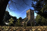
Warburton has a history of settlement stretching back to the 11th century, with the possibility of earlier habitation. There are 17 listed buildings in the village, including the timber framed
Grade I Church of St Werburgh
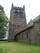
, which is at least 700 years old. Among the other listed buildings are examples of architect John Douglas’
work, including the second Church of St Werburgh, built in 1883. In 2006, Time Team
excavated in the lands of Moss Brow Farm in Warburton, looking for a Roman fortlet.
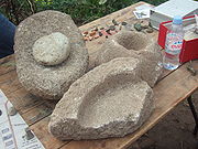 Some limited evidence has been found of activity on the site of Warburton dating from the Bronze Age
, through the Iron Age
and Roman periods; these include a flint blade, six Mesolithic
tools, pieces of quernstone, and a snake bracelet. Archaeological evidence indicates that the area around Warburton has been used agriculturally since at least the Roman times. In the Domesday Book, the name was Warburgtune which name has evolved to today's ‘Warburton’. The suffix –ton means a settlement or farmstead in Old English, indicating that the settlement has pre-Conquest origins. It has been suggested that Warburton was the site of an Anglo-Saxon burgh or defended settlement, called Weard byrig, established by Aethelflaed, Queen of the Mercians, in 915 during the wars with the Viking
s. However, it now seems likely that site lay on the Wales–Cheshire border.
The first documented reference to Warburton occurs in the Domesday Book
, where the two manor
s of Warburton were recorded; the manors were united by the late 12th century. Before the Norman conquest, the area was controlled by the Anglo-Saxon thegn
Aelfward. Although the Domesday Book records no church in Warburton, it is possible that the church dedicated to Saint Werburgh is pre-Conquest. The omission of the church may not be significant, as not all pre-Conquest churches or chapels were recorded in the Domesday survey. The first documented evidence of a church in Warburton was in a deed of 1187, when it was a chapel of ease
for the parish of Lymm
. Warburton became a separate parish in the 13th century. The church is surrounded by a ditch and bank, probably dating to at least the 14th century. Warburton is also the site of a medieval priory
, near the Church of St Werburgh; although the priory was only formed in the 13th century, it was dissolved in 1270.
Warburton was predominantly a farming village during the medieval period. The north western corner of the township was used as a deer park. Warburton grew as an agricultural town during the medieval period, and it remained almost untouched by the Industrial Revolution
; this is reflected in the population change between 1801 and 1901, dropping from 466 to 403, with little variation at a time when the rest of Trafford was expanding rapidly.
Warburton TollBridge
Warburton Bridge is a privately owned Statutory Tolled Undertaking which incorporates a public highway road length. The high-level cantilever bridge crosses the Manchester Ship Canal
on the B5159 road, connecting the A57
with the A6144. The toll was originally charged for crossing the old stone bridge across the now dried up bed of the diverted River Mersey
, originally built in 1863, by Act of Parliament. However, alongside this, the toll contributes towards the upkeep and maintenance of both bridges and the unadopted approach roads on both sides. The toll operation has a significant impact with both maintaining the smooth flow of traffic into the surrounding areas, along with the detection of unauthorised vehicles attempting to use this 3 ton weight restricted route. The current single crossing toll is 12p. However, a 25p ticket can be purchased and used all day, on the day of purchase. Yearly Badge passes are also available from the Manchester Ship Canal Company by request. Tolls are charged from 7am-10pm Monday to Friday, 8am-10pm on a Saturday and 9am-10pm on Sundays. At 10pm until the following morning there is no charge to cross. It is one of the few remaining pre-motorway toll bridges in the United Kingdom, and the only one in Greater Manchester.
parish of Warburton was created in 1894, under the Local Government Act 1894
and has its own parish council. Warburton became part of the Metropolitan Borough of Trafford
in 1974 upon the borough's creation, but was previously in Bucklow Rural District
. The village is part of the Bowdon
electoral ward; the councillors for the Bowdon ward are David Merrell, Paula Pearson, and Stephanie Poole, all Conservative
. Warburton is also a part of the Altrincham and Sale West constituency, and is part of the North West England constituency
of the European Parliament. Since the formation of the Altrincham and Sale West constituency in 1997 it had been represented in the House of Commons
by the Conservative MP, Graham Brady
. At the 2005 General Election
, the Conservatives won a majority of 7,159 and 46.4% of the vote. Labour
won 30.3% of the vote, Liberal Democrats
21.7% and the United Kingdom Independence Party
1.7%.
lies to the south west of Warburton in the borough of Warrington
, with the River Bollin
forming the border between the two villages. The Bollin joins the River Mersey
in the village; however the Mersey in Warburton has dried up, as it was diverted into the Manchester Ship Canal
further upstream. To the east lie Dunham Town
, Dunham Massey
, Bowdon
and Altrincham
, with Little Bollington
to the south, and Partington and Urmston
to the north. The local geology is lower keuper marl
, with a ridge of sand and gravel running from Warburton to Dunham.
The main roads running through Warburton are the A6144 and B5159. Two local bus services, 5 (operated by Warrington Borough Transport) and 38 (operated by Warrington Coachways) link Warburton with Warrington
and Altrincham
.
, Warburton had a total population of 286. For every 100 females, there were 121.7 males. The average household size was 2.44. Of those aged 16–74 in Warburton, 43.2% had no academic qualifications or one GCSE, similar to the figures for all of Trafford (40.8%) and in England (45.5%). According to the census, 1.40% were unemployed and 33.49% were economically inactive. 16.43% of the population were under the age of 16 and 6.64% were aged 75 and over; the mean age of the people of Warburton was 43.03. 69.34% of residents described their health as 'good'.
church and a Grade I Listed Building, one of six in Trafford. Of the 29 timber framed churches that survive in England and Wales
, St Werbugh’s is one of the oldest. The church dates to at least the 14th century, and may be built on the site of an earlier Saxon chapel. It is rarely used for worship but is accessible to visitors. The church features an early-17th-century font
, a Jacobean
pulpit, and a 1645 altar. Nearby are the remains of the old village cross, complete with stocks
whose wooden restraints are modern, though the supporting pillars are much older. The other church in Warburton, also dedicated to St Werburgh, was built in 1883 by John Douglas
and is a Grade II Listed Building. The church is made of red sandstone
with a clay tile roof.
 As well as the two churches dedicated to Saint Werburgh, there are 15 other Grade II listed buildings. The parish rooms and caretaker
's house were built in 1889, and designed by John Douglas
. Also built in the village by Douglas was the post office
in 1893, and Warburton School
in 1871–72; this has been converted to a residence but still features cruck
s supporting the roof. Some farm buildings in Warburton are also listed, including the farmhouse on Moss Lane. The barn is 18th century but features crucks which may be 17th century or earlier. The timber framed
farm building on Park Road is 17th century in origin; the late 18th-century farmhouse on Warburton Lane was made with Flemish bond brick and has a slate roof. The barn on Paddock Lane dates from the 17th century. Also on Paddock Lane are two farmhouses: one was built in 1717 by Thomas Egerton and features an inglenook
fireplace; the other is Wigsey farmhouse which was originally built in the 17th century with later additions including a 19th-century porch. The building on Warburton Lane near Villa Farmhouse was originally a timber framed building from the 16th or early 17th century. The house features late-16th- or early-17th-century fresco
s of a woman, possibly St Werburgh, with two geese and a rose.
There is the base of a stone cross on Townfield Lane, and wooden stocks nearby, probably dating from the 17th century. One of the more unusual listed structures in Warburton is the 25 m stretch of wall constructed from flagstones, probably built in the 18th or 19th century. There are two listed structures in the grounds of the old Church of St Werburgh: a lychgate
from the late 19th century, and a sundial from 1765.
 Since 1998, archaeological techniques such as field walking have led to the discovery of finds ranging in age from prehistoric flints and Bronze Age
axe heads to Roman and late medieval finds. Featuring prominently amongst these finds were Roman artefacts including coins, broaches and a snake bracelet. At the invitation of local historian Jim Balme, Time Team
excavated in Warburton in September 2006. They were searching for a Roman
fortlet that previous archaeological digs by South Trafford Archaeological Group
(STAG) indicated might be present. Though no evidence of a Roman fortlet was found, the discovery of strip lynchets indicates that there was a Romano-British
farm in Warburton. The presence of Roman finds was explained as rubbish, mixed in with manure to be spread on the crops.
Civil parish
In England, a civil parish is a territorial designation and, where they are found, the lowest tier of local government below districts and counties...
within the Metropolitan Borough of Trafford
Trafford
The Metropolitan Borough of Trafford is a metropolitan borough of Greater Manchester, England. It has a population of 211,800, covers , and includes the towns of Altrincham, Partington, Sale, Stretford, and Urmston...
in Greater Manchester
Greater Manchester
Greater Manchester is a metropolitan county in North West England, with a population of 2.6 million. It encompasses one of the largest metropolitan areas in the United Kingdom and comprises ten metropolitan boroughs: Bolton, Bury, Oldham, Rochdale, Stockport, Tameside, Trafford, Wigan, and the...
, England. Historically
Historic counties of England
The historic counties of England are subdivisions of England established for administration by the Normans and in most cases based on earlier Anglo-Saxon kingdoms and shires...
a part of Cheshire
Cheshire
Cheshire is a ceremonial county in North West England. Cheshire's county town is the city of Chester, although its largest town is Warrington. Other major towns include Widnes, Congleton, Crewe, Ellesmere Port, Runcorn, Macclesfield, Winsford, Northwich, and Wilmslow...
, Warburton lies on the south bank of the River Mersey
River Mersey
The River Mersey is a river in North West England. It is around long, stretching from Stockport, Greater Manchester, and ending at Liverpool Bay, Merseyside. For centuries, it formed part of the ancient county divide between Lancashire and Cheshire....
between the borough of Warrington
Warrington
Warrington is a town, borough and unitary authority area of Cheshire, England. It stands on the banks of the River Mersey, which is tidal to the west of the weir at Howley. It lies 16 miles east of Liverpool, 19 miles west of Manchester and 8 miles south of St Helens...
and Greater Manchester. Today, the village remains predominantly rural. Altrincham
Altrincham
Altrincham is a market town within the Metropolitan Borough of Trafford, in Greater Manchester, England. It lies on flat ground south of the River Mersey about southwest of Manchester city centre, south-southwest of Sale and east of Warrington...
is the nearest town. According to the 2001 census, the parish had a population of 286.
Warburton has a history of settlement stretching back to the 11th century, with the possibility of earlier habitation. There are 17 listed buildings in the village, including the timber framed
Timber framing
Timber framing , or half-timbering, also called in North America "post-and-beam" construction, is the method of creating structures using heavy squared off and carefully fitted and joined timbers with joints secured by large wooden pegs . It is commonplace in large barns...
Grade I Church of St Werburgh
St Werburgh's Church, Warburton
St Werburgh's Church, Warburton is the name of two separate churches in the village of Warburton, Greater Manchester, England. The older church is located to the west of the village, and may date back as far as the middle of the 13th century. It is now a redundant church but services are held...
, which is at least 700 years old. Among the other listed buildings are examples of architect John Douglas’
John Douglas (architect)
John Douglas was an English architect who designed about 500 buildings in Cheshire, North Wales, and northwest England, in particular in the estate of Eaton Hall. He was trained in Lancaster and practised throughout his career from an office in Chester, Cheshire...
work, including the second Church of St Werburgh, built in 1883. In 2006, Time Team
Time Team
Time Team is a British television series which has been aired on Channel 4 since 1994. Created by television producer Tim Taylor and presented by actor Tony Robinson, each episode features a team of specialists carrying out an archaeological dig over a period of three days, with Robinson explaining...
excavated in the lands of Moss Brow Farm in Warburton, looking for a Roman fortlet.
History
Bronze Age
The Bronze Age is a period characterized by the use of copper and its alloy bronze as the chief hard materials in the manufacture of some implements and weapons. Chronologically, it stands between the Stone Age and Iron Age...
, through the Iron Age
Iron Age
The Iron Age is the archaeological period generally occurring after the Bronze Age, marked by the prevalent use of iron. The early period of the age is characterized by the widespread use of iron or steel. The adoption of such material coincided with other changes in society, including differing...
and Roman periods; these include a flint blade, six Mesolithic
Mesolithic
The Mesolithic is an archaeological concept used to refer to certain groups of archaeological cultures defined as falling between the Paleolithic and the Neolithic....
tools, pieces of quernstone, and a snake bracelet. Archaeological evidence indicates that the area around Warburton has been used agriculturally since at least the Roman times. In the Domesday Book, the name was Warburgtune which name has evolved to today's ‘Warburton’. The suffix –ton means a settlement or farmstead in Old English, indicating that the settlement has pre-Conquest origins. It has been suggested that Warburton was the site of an Anglo-Saxon burgh or defended settlement, called Weard byrig, established by Aethelflaed, Queen of the Mercians, in 915 during the wars with the Viking
Viking
The term Viking is customarily used to refer to the Norse explorers, warriors, merchants, and pirates who raided, traded, explored and settled in wide areas of Europe, Asia and the North Atlantic islands from the late 8th to the mid-11th century.These Norsemen used their famed longships to...
s. However, it now seems likely that site lay on the Wales–Cheshire border.
The first documented reference to Warburton occurs in the Domesday Book
Domesday Book
Domesday Book , now held at The National Archives, Kew, Richmond upon Thames in South West London, is the record of the great survey of much of England and parts of Wales completed in 1086...
, where the two manor
Manorialism
Manorialism, an essential element of feudal society, was the organizing principle of rural economy that originated in the villa system of the Late Roman Empire, was widely practiced in medieval western and parts of central Europe, and was slowly replaced by the advent of a money-based market...
s of Warburton were recorded; the manors were united by the late 12th century. Before the Norman conquest, the area was controlled by the Anglo-Saxon thegn
Thegn
The term thegn , from OE þegn, ðegn "servant, attendant, retainer", is commonly used to describe either an aristocratic retainer of a king or nobleman in Anglo-Saxon England, or as a class term, the majority of the aristocracy below the ranks of ealdormen and high-reeves...
Aelfward. Although the Domesday Book records no church in Warburton, it is possible that the church dedicated to Saint Werburgh is pre-Conquest. The omission of the church may not be significant, as not all pre-Conquest churches or chapels were recorded in the Domesday survey. The first documented evidence of a church in Warburton was in a deed of 1187, when it was a chapel of ease
Chapel of ease
A chapel of ease is a church building other than the parish church, built within the bounds of a parish for the attendance of those who cannot reach the parish church conveniently....
for the parish of Lymm
Lymm
Lymm is a large village and civil parish within the Warrington borough of Cheshire, in North West England. Lymm was an urban district of Cheshire from 1894 to 1974. The civil parish of Lymm incorporates the hamlets of Booths Hill, Broomedge, Church Green, Deansgreen, Heatley, Heatley Heath, Little...
. Warburton became a separate parish in the 13th century. The church is surrounded by a ditch and bank, probably dating to at least the 14th century. Warburton is also the site of a medieval priory
Priory
A priory is a house of men or women under religious vows that is headed by a prior or prioress. Priories may be houses of mendicant friars or religious sisters , or monasteries of monks or nuns .The Benedictines and their offshoots , the Premonstratensians, and the...
, near the Church of St Werburgh; although the priory was only formed in the 13th century, it was dissolved in 1270.
Warburton was predominantly a farming village during the medieval period. The north western corner of the township was used as a deer park. Warburton grew as an agricultural town during the medieval period, and it remained almost untouched by the Industrial Revolution
Industrial Revolution
The Industrial Revolution was a period from the 18th to the 19th century where major changes in agriculture, manufacturing, mining, transportation, and technology had a profound effect on the social, economic and cultural conditions of the times...
; this is reflected in the population change between 1801 and 1901, dropping from 466 to 403, with little variation at a time when the rest of Trafford was expanding rapidly.
Warburton TollBridge
Warburton Bridge is a privately owned Statutory Tolled Undertaking which incorporates a public highway road length. The high-level cantilever bridge crosses the Manchester Ship Canal
Manchester Ship Canal
The Manchester Ship Canal is a river navigation 36 miles long in the North West of England. Starting at the Mersey Estuary near Liverpool, it generally follows the original routes of the rivers Mersey and Irwell through the historic counties of Cheshire and Lancashire. Several sets of locks lift...
on the B5159 road, connecting the A57
A57 road
The A57 is a major road in England. It runs east from Liverpool to Lincoln, via Warrington, Cadishead, Irlam, Patricroft, Eccles, Salford and Manchester, then through the Pennines over the Snake Pass , around the Ladybower Reservoir, through Sheffield and past Worksop...
with the A6144. The toll was originally charged for crossing the old stone bridge across the now dried up bed of the diverted River Mersey
River Mersey
The River Mersey is a river in North West England. It is around long, stretching from Stockport, Greater Manchester, and ending at Liverpool Bay, Merseyside. For centuries, it formed part of the ancient county divide between Lancashire and Cheshire....
, originally built in 1863, by Act of Parliament. However, alongside this, the toll contributes towards the upkeep and maintenance of both bridges and the unadopted approach roads on both sides. The toll operation has a significant impact with both maintaining the smooth flow of traffic into the surrounding areas, along with the detection of unauthorised vehicles attempting to use this 3 ton weight restricted route. The current single crossing toll is 12p. However, a 25p ticket can be purchased and used all day, on the day of purchase. Yearly Badge passes are also available from the Manchester Ship Canal Company by request. Tolls are charged from 7am-10pm Monday to Friday, 8am-10pm on a Saturday and 9am-10pm on Sundays. At 10pm until the following morning there is no charge to cross. It is one of the few remaining pre-motorway toll bridges in the United Kingdom, and the only one in Greater Manchester.
Governance
The civil parishCivil parish
In England, a civil parish is a territorial designation and, where they are found, the lowest tier of local government below districts and counties...
parish of Warburton was created in 1894, under the Local Government Act 1894
Local Government Act 1894
The Local Government Act 1894 was an Act of the Parliament of the United Kingdom that reformed local government in England and Wales outside the County of London. The Act followed the reforms carried out at county level under the Local Government Act 1888...
and has its own parish council. Warburton became part of the Metropolitan Borough of Trafford
Trafford
The Metropolitan Borough of Trafford is a metropolitan borough of Greater Manchester, England. It has a population of 211,800, covers , and includes the towns of Altrincham, Partington, Sale, Stretford, and Urmston...
in 1974 upon the borough's creation, but was previously in Bucklow Rural District
Bucklow Rural District
Bucklow Rural District was, from 1894 to 1974, a local government district in the north of the administrative county of Cheshire, England. Following the Local Government Act 1972, this rural district was split between the new Greater Manchester boroughs of Trafford and Manchester, and Macclesfield,...
. The village is part of the Bowdon
Bowdon, Greater Manchester
Bowdon is a suburban village and electoral ward in the Altrincham area of the Metropolitan Borough of Trafford, in Greater Manchester, England.-History:...
electoral ward; the councillors for the Bowdon ward are David Merrell, Paula Pearson, and Stephanie Poole, all Conservative
Conservative Party (UK)
The Conservative Party, formally the Conservative and Unionist Party, is a centre-right political party in the United Kingdom that adheres to the philosophies of conservatism and British unionism. It is the largest political party in the UK, and is currently the largest single party in the House...
. Warburton is also a part of the Altrincham and Sale West constituency, and is part of the North West England constituency
North West England (European Parliament constituency)
North West England is a constituency of the European Parliament. For the 2009 elections it elects 8 MEPs using the d'Hondt method of party-list proportional representation.-Boundaries:...
of the European Parliament. Since the formation of the Altrincham and Sale West constituency in 1997 it had been represented in the House of Commons
British House of Commons
The House of Commons is the lower house of the Parliament of the United Kingdom, which also comprises the Sovereign and the House of Lords . Both Commons and Lords meet in the Palace of Westminster. The Commons is a democratically elected body, consisting of 650 members , who are known as Members...
by the Conservative MP, Graham Brady
Graham Brady
Graham Stuart Brady is a British Conservative Party politician and the Member of Parliament for Altrincham and Sale West. He served as a shadow minister for Europe under four Conservative leaders before resigning in 2007 in protest at David Cameron's opposition to grammar schools...
. At the 2005 General Election
United Kingdom general election, 2005
The United Kingdom general election of 2005 was held on Thursday, 5 May 2005 to elect 646 members to the British House of Commons. The Labour Party under Tony Blair won its third consecutive victory, but with a majority of 66, reduced from 160....
, the Conservatives won a majority of 7,159 and 46.4% of the vote. Labour
Labour Party (UK)
The Labour Party is a centre-left democratic socialist party in the United Kingdom. It surpassed the Liberal Party in general elections during the early 1920s, forming minority governments under Ramsay MacDonald in 1924 and 1929-1931. The party was in a wartime coalition from 1940 to 1945, after...
won 30.3% of the vote, Liberal Democrats
Liberal Democrats
The Liberal Democrats are a social liberal political party in the United Kingdom which supports constitutional and electoral reform, progressive taxation, wealth taxation, human rights laws, cultural liberalism, banking reform and civil liberties .The party was formed in 1988 by a merger of the...
21.7% and the United Kingdom Independence Party
United Kingdom Independence Party
The United Kingdom Independence Party is a eurosceptic and right-wing populist political party in the United Kingdom. Whilst its primary goal is the UK's withdrawal from the European Union, the party has expanded beyond its single-issue image to develop a more comprehensive party platform.UKIP...
1.7%.
Geography
The village of LymmLymm
Lymm is a large village and civil parish within the Warrington borough of Cheshire, in North West England. Lymm was an urban district of Cheshire from 1894 to 1974. The civil parish of Lymm incorporates the hamlets of Booths Hill, Broomedge, Church Green, Deansgreen, Heatley, Heatley Heath, Little...
lies to the south west of Warburton in the borough of Warrington
Warrington
Warrington is a town, borough and unitary authority area of Cheshire, England. It stands on the banks of the River Mersey, which is tidal to the west of the weir at Howley. It lies 16 miles east of Liverpool, 19 miles west of Manchester and 8 miles south of St Helens...
, with the River Bollin
River Bollin
The River Bollin is a major tributary of the River Mersey in the north-west of England.It rises in Macclesfield Forest at the western end of the Peak District, and can be seen in spring form, from the Buxton to Macclesfield road. The stream then descends the through Macclesfield and Wilmslow where...
forming the border between the two villages. The Bollin joins the River Mersey
River Mersey
The River Mersey is a river in North West England. It is around long, stretching from Stockport, Greater Manchester, and ending at Liverpool Bay, Merseyside. For centuries, it formed part of the ancient county divide between Lancashire and Cheshire....
in the village; however the Mersey in Warburton has dried up, as it was diverted into the Manchester Ship Canal
Manchester Ship Canal
The Manchester Ship Canal is a river navigation 36 miles long in the North West of England. Starting at the Mersey Estuary near Liverpool, it generally follows the original routes of the rivers Mersey and Irwell through the historic counties of Cheshire and Lancashire. Several sets of locks lift...
further upstream. To the east lie Dunham Town
Dunham Town
Dunham Town is a village in the civil parish of Dunham Massey in the Metropolitan Borough of Trafford, Greater Manchester, England. It was historically a part of Cheshire.- History :...
, Dunham Massey
Dunham Massey
Dunham Massey is a civil parish in the Metropolitan Borough of Trafford, Greater Manchester, England. The parish includes the villages of Sinderland Green, Dunham Woodhouse and Dunham Town, along with Dunham Massey Park, formerly the home of the last Earl of Stamford and owned by the National Trust...
, Bowdon
Bowdon, Greater Manchester
Bowdon is a suburban village and electoral ward in the Altrincham area of the Metropolitan Borough of Trafford, in Greater Manchester, England.-History:...
and Altrincham
Altrincham
Altrincham is a market town within the Metropolitan Borough of Trafford, in Greater Manchester, England. It lies on flat ground south of the River Mersey about southwest of Manchester city centre, south-southwest of Sale and east of Warrington...
, with Little Bollington
Little Bollington
Little Bollington is a village and civil parish in the unitary authority of Cheshire East and the ceremonial county of Cheshire, England. The Bridgewater Canal runs through the western side of the parish from south-west to north, and Dunham Park lies to the north east of the parish, across the...
to the south, and Partington and Urmston
Urmston
Urmston is a town within the Metropolitan Borough of Trafford, in Greater Manchester, England, with a population of around 41,000. Historically a part of Lancashire, it lies about six miles to the southwest of Manchester city centre. The southern boundary is marked by the River Mersey and the...
to the north. The local geology is lower keuper marl
Keuper marl
Keuper marl is the former name for a layer of mudstones and siltstones from the late Triassic period . Typically red, or occasionally...
, with a ridge of sand and gravel running from Warburton to Dunham.
The main roads running through Warburton are the A6144 and B5159. Two local bus services, 5 (operated by Warrington Borough Transport) and 38 (operated by Warrington Coachways) link Warburton with Warrington
Warrington
Warrington is a town, borough and unitary authority area of Cheshire, England. It stands on the banks of the River Mersey, which is tidal to the west of the weir at Howley. It lies 16 miles east of Liverpool, 19 miles west of Manchester and 8 miles south of St Helens...
and Altrincham
Altrincham
Altrincham is a market town within the Metropolitan Borough of Trafford, in Greater Manchester, England. It lies on flat ground south of the River Mersey about southwest of Manchester city centre, south-southwest of Sale and east of Warrington...
.
Demography
As of the 2001 UK censusUnited Kingdom Census 2001
A nationwide census, known as Census 2001, was conducted in the United Kingdom on Sunday, 29 April 2001. This was the 20th UK Census and recorded a resident population of 58,789,194....
, Warburton had a total population of 286. For every 100 females, there were 121.7 males. The average household size was 2.44. Of those aged 16–74 in Warburton, 43.2% had no academic qualifications or one GCSE, similar to the figures for all of Trafford (40.8%) and in England (45.5%). According to the census, 1.40% were unemployed and 33.49% were economically inactive. 16.43% of the population were under the age of 16 and 6.64% were aged 75 and over; the mean age of the people of Warburton was 43.03. 69.34% of residents described their health as 'good'.
Population change
| Population growth Population growth Population growth is the change in a population over time, and can be quantified as the change in the number of individuals of any species in a population using "per unit time" for measurement.... in Warburton since 1801 |
||||||||||||||||||
|---|---|---|---|---|---|---|---|---|---|---|---|---|---|---|---|---|---|---|
| Year | 1801 | 1811 | 1821 | 1831 | 1841 | 1851 | 1861 | 1871 | 1881 | 1891 | 1901 | 1911 | 1921 | 1931 | 1951 | 1961 | 1971 | 2001 |
| Population | 466 | 470 | 509 | 510 | 509 | 489 | 484 | 452 | 426 | 416 | 403 | 403 | 379 | 354 | 376 | 328 | 289 | 286 |
| Source: A Vision of Britain through Time | ||||||||||||||||||
Churches
Warburton has two churches of note. St Werburgh’s is a timber framedTimber framing
Timber framing , or half-timbering, also called in North America "post-and-beam" construction, is the method of creating structures using heavy squared off and carefully fitted and joined timbers with joints secured by large wooden pegs . It is commonplace in large barns...
church and a Grade I Listed Building, one of six in Trafford. Of the 29 timber framed churches that survive in England and Wales
England and Wales
England and Wales is a jurisdiction within the United Kingdom. It consists of England and Wales, two of the four countries of the United Kingdom...
, St Werbugh’s is one of the oldest. The church dates to at least the 14th century, and may be built on the site of an earlier Saxon chapel. It is rarely used for worship but is accessible to visitors. The church features an early-17th-century font
Baptismal font
A baptismal font is an article of church furniture or a fixture used for the baptism of children and adults.-Aspersion and affusion fonts:...
, a Jacobean
Jacobean architecture
The Jacobean style is the second phase of Renaissance architecture in England, following the Elizabethan style. It is named after King James I of England, with whose reign it is associated.-Characteristics:...
pulpit, and a 1645 altar. Nearby are the remains of the old village cross, complete with stocks
Stocks
Stocks are devices used in the medieval and colonial American times as a form of physical punishment involving public humiliation. The stocks partially immobilized its victims and they were often exposed in a public place such as the site of a market to the scorn of those who passed by...
whose wooden restraints are modern, though the supporting pillars are much older. The other church in Warburton, also dedicated to St Werburgh, was built in 1883 by John Douglas
John Douglas (architect)
John Douglas was an English architect who designed about 500 buildings in Cheshire, North Wales, and northwest England, in particular in the estate of Eaton Hall. He was trained in Lancaster and practised throughout his career from an office in Chester, Cheshire...
and is a Grade II Listed Building. The church is made of red sandstone
Sandstone
Sandstone is a sedimentary rock composed mainly of sand-sized minerals or rock grains.Most sandstone is composed of quartz and/or feldspar because these are the most common minerals in the Earth's crust. Like sand, sandstone may be any colour, but the most common colours are tan, brown, yellow,...
with a clay tile roof.
Grade II listed buildings
Property caretaker
A Property caretaker is a person, group or organization that cares for real estate for trade or financial compensation, and sometimes as a barter for rent-free living accommodations...
's house were built in 1889, and designed by John Douglas
John Douglas (architect)
John Douglas was an English architect who designed about 500 buildings in Cheshire, North Wales, and northwest England, in particular in the estate of Eaton Hall. He was trained in Lancaster and practised throughout his career from an office in Chester, Cheshire...
. Also built in the village by Douglas was the post office
Post office
A post office is a facility forming part of a postal system for the posting, receipt, sorting, handling, transmission or delivery of mail.Post offices offer mail-related services such as post office boxes, postage and packaging supplies...
in 1893, and Warburton School
Warburton School
Warburton School is on the south side of Dunham Road in the village of Warburton, Greater Manchester, England. It has been converted into a house and is a Grade II listed building....
in 1871–72; this has been converted to a residence but still features cruck
Cruck
A cruck or crook frame is a curved timber, one of a pair, which supports the roof of a building, used particularly in England. This type of timber framing consists of long, generally bent, timber beams that lean inwards and form the ridge of the roof. These posts are then generally secured by a...
s supporting the roof. Some farm buildings in Warburton are also listed, including the farmhouse on Moss Lane. The barn is 18th century but features crucks which may be 17th century or earlier. The timber framed
Timber framing
Timber framing , or half-timbering, also called in North America "post-and-beam" construction, is the method of creating structures using heavy squared off and carefully fitted and joined timbers with joints secured by large wooden pegs . It is commonplace in large barns...
farm building on Park Road is 17th century in origin; the late 18th-century farmhouse on Warburton Lane was made with Flemish bond brick and has a slate roof. The barn on Paddock Lane dates from the 17th century. Also on Paddock Lane are two farmhouses: one was built in 1717 by Thomas Egerton and features an inglenook
Inglenook
An inglenook , or chimney corner, is a small recess that adjoins a fireplace.Inglenook may also refer to:*Inglenook, California, community in Mendocino County...
fireplace; the other is Wigsey farmhouse which was originally built in the 17th century with later additions including a 19th-century porch. The building on Warburton Lane near Villa Farmhouse was originally a timber framed building from the 16th or early 17th century. The house features late-16th- or early-17th-century fresco
Fresco
Fresco is any of several related mural painting types, executed on plaster on walls or ceilings. The word fresco comes from the Greek word affresca which derives from the Latin word for "fresh". Frescoes first developed in the ancient world and continued to be popular through the Renaissance...
s of a woman, possibly St Werburgh, with two geese and a rose.
There is the base of a stone cross on Townfield Lane, and wooden stocks nearby, probably dating from the 17th century. One of the more unusual listed structures in Warburton is the 25 m stretch of wall constructed from flagstones, probably built in the 18th or 19th century. There are two listed structures in the grounds of the old Church of St Werburgh: a lychgate
Lychgate
A lychgate, also spelled lichgate, lycugate, or as two separate words lych gate, is a gateway covered with a roof found at the entrance to a traditional English or English-style churchyard.-Name:...
from the late 19th century, and a sundial from 1765.
Time Team in Warburton
Bronze Age
The Bronze Age is a period characterized by the use of copper and its alloy bronze as the chief hard materials in the manufacture of some implements and weapons. Chronologically, it stands between the Stone Age and Iron Age...
axe heads to Roman and late medieval finds. Featuring prominently amongst these finds were Roman artefacts including coins, broaches and a snake bracelet. At the invitation of local historian Jim Balme, Time Team
Time Team
Time Team is a British television series which has been aired on Channel 4 since 1994. Created by television producer Tim Taylor and presented by actor Tony Robinson, each episode features a team of specialists carrying out an archaeological dig over a period of three days, with Robinson explaining...
excavated in Warburton in September 2006. They were searching for a Roman
Ancient Rome
Ancient Rome was a thriving civilization that grew on the Italian Peninsula as early as the 8th century BC. Located along the Mediterranean Sea and centered on the city of Rome, it expanded to one of the largest empires in the ancient world....
fortlet that previous archaeological digs by South Trafford Archaeological Group
South Trafford Archaeological Group
The South Trafford Archaeological Group is an archaeological group based in Timperley, Greater Manchester. The group promotes interest in and the study of archaeology and history locally, especially within Trafford but also beyond the borders of the borough...
(STAG) indicated might be present. Though no evidence of a Roman fortlet was found, the discovery of strip lynchets indicates that there was a Romano-British
Romano-British
Romano-British culture describes the culture that arose in Britain under the Roman Empire following the Roman conquest of AD 43 and the creation of the province of Britannia. It arose as a fusion of the imported Roman culture with that of the indigenous Britons, a people of Celtic language and...
farm in Warburton. The presence of Roman finds was explained as rubbish, mixed in with manure to be spread on the crops.
External links
- Archaeological discoveries The official James Balme website
- Location map (Multimap)
- Time Team in Warburton (Discussions: Time Team forum, TTF forum)
- Warburton War Memorial