
Walker Falls
Encyclopedia
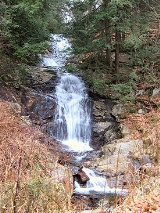
Walker Falls is a 45-foot cascading waterfall
in Buncombe County, North Carolina. Its ease of access makes it a popular destination for Waterfall Hunters
. It is in a region of Buncombe County that has a large number of small waterfalls and several larger falls.
near Barnardsville, North Carolina
.
and Dillingham Rd. in Barnardsville and go 2.2 miles on Dillingham Rd. to a fork in the road. Take the left fork and go 2.7 miles, when the road turns to gravel and becomes Forest Road 74. Go 2.8 miles more to see a small sliding waterfall. 1.3 miles later, you will come up on Walker Falls. You may then go 4.7 miles further down Forest Road 74 to the parking area for Douglas Falls
.
If you are coming from the Blue Ridge Parkway, follow Forest Road 63 (if it is not gated) to Dillingham Road. Turn right, and in 1.4 miles you will reach the point where the road becomes Forest Road 74. Continue following the directions as above.
Note: Dillingham Rd. only has one way in and out. If you do not plan to visit the falls further down Dillingham Rd. you'll need to go back out the way you entered.
Waterfall
A waterfall is a place where flowing water rapidly drops in elevation as it flows over a steep region or a cliff.-Formation:Waterfalls are commonly formed when a river is young. At these times the channel is often narrow and deep. When the river courses over resistant bedrock, erosion happens...
in Buncombe County, North Carolina. Its ease of access makes it a popular destination for Waterfall Hunters
Hiking
Hiking is an outdoor activity which consists of walking in natural environments, often in mountainous or other scenic terrain. People often hike on hiking trails. It is such a popular activity that there are numerous hiking organizations worldwide. The health benefits of different types of hiking...
. It is in a region of Buncombe County that has a large number of small waterfalls and several larger falls.
Natural history
The falls is located on Walker Branch in the Pisgah National ForestPisgah National Forest
Pisgah National Forest is a National Forest in the Appalachian Mountains of western North Carolina. It is administered by the United States Forest Service, part of the United States Department of Agriculture. The Pisgah National Forest is completely contained within the state of North Carolina...
near Barnardsville, North Carolina
Barnardsville, North Carolina
Barnardsville is an unincorporated community that was a small town in Buncombe County , North Carolina, USA, near Asheville until its disincorporation in 1970. It is located at Latitude 35.762741 Longitude -82.433296 and has a population of 1,647. The community is part of the Asheville Metropolitan...
.
Visiting the Falls
The falls is viewable on the side of the road. To view the falls, from the intersection of NC 197North Carolina Highway 197
North Carolina Highway 197 is a north/south state highway in Western North Carolina. The route is approximately 65 miles in length and with its continuation into Tennessee as SR 395 connects Erwin, Tennessee to Flat Creek, North Carolina...
and Dillingham Rd. in Barnardsville and go 2.2 miles on Dillingham Rd. to a fork in the road. Take the left fork and go 2.7 miles, when the road turns to gravel and becomes Forest Road 74. Go 2.8 miles more to see a small sliding waterfall. 1.3 miles later, you will come up on Walker Falls. You may then go 4.7 miles further down Forest Road 74 to the parking area for Douglas Falls
Douglas Falls
Douglas Falls are a 60 foot waterfall located in Buncombe County, North Carolina, USA. It is on a tributary of Waterfall Creek which flows into the Ivy River, and it is within the Big Ivy section of the Pisgah National Forest. The stream flows off the slope of Craggy Pinnacle, starting just below...
.
If you are coming from the Blue Ridge Parkway, follow Forest Road 63 (if it is not gated) to Dillingham Road. Turn right, and in 1.4 miles you will reach the point where the road becomes Forest Road 74. Continue following the directions as above.
Note: Dillingham Rd. only has one way in and out. If you do not plan to visit the falls further down Dillingham Rd. you'll need to go back out the way you entered.
Nearby Falls
- Several Unnamed Falls
- Douglas FallsDouglas FallsDouglas Falls are a 60 foot waterfall located in Buncombe County, North Carolina, USA. It is on a tributary of Waterfall Creek which flows into the Ivy River, and it is within the Big Ivy section of the Pisgah National Forest. The stream flows off the slope of Craggy Pinnacle, starting just below...
- Glassmine FallsGlassmine FallsGlassmine Falls is an ephemeral waterfall in Buncombe County, North Carolina, on Glassmine Branch, near Dillingham, North Carolina.-Geology:When it flows, the falls slides down the rock face of Blackstop Knob Mountain down to the North Fork Swannanoa River. The flow is not constant and can...
- Mitchell FallsMitchell FallsMitchell Falls is a waterfall located on private property in Yancey County, North Carolina on the slope of Mount Mitchell, the highest mountain in the Appalachian Mountain chain, and highest point in the eastern United States...
- Setrock Creek FallsSetrock Creek Falls-Geology:The falls is located at the base of Mount Mitchell, the tallest mountain in the United States east of the Mississippi River, on Setrock Creek, a small tributary of the South Toe River, which itself is a tributary of the French Broad River. The creek falls over multiple steep to...
- Roaring Fork FallsRoaring Fork Falls (Yancey County)Roaring Fork Falls, also called Roaring Creek Falls, is a waterfall in the Pisgah National Forest, in North Carolina.-Geology:The falls is located on Roaring Fork, a tributary of the South Toe River, which itself is a tributary of the French Broad River. The creek is located in a forest that's...
- Whiteoak Creek FallsWhiteoak Creek Falls-Geology:The falls is located on Whiteoak Creek, a tributary of the South Toe River, which itself is a tributary of the French Broad River.-Height:There are multiple cascades, slides and drops...