
Glassmine Falls
Encyclopedia
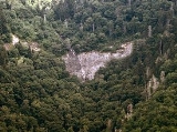
Glassmine Falls is an ephemeral waterfall in Buncombe County, North Carolina
, on Glassmine Branch, near Dillingham, North Carolina.
. The flow is not constant and can sometimes nearly dry up completely. It is most visible after heavy rains, which can be at any time during the year. A sign at the overlook for the falls claims that the falls is over 800 ft (247m) high. At this height, Glassmine Falls is one of the tallest waterfalls east of the Mississippi River
.
mine. The miners referred to the mineral they mined as "glass", which is how the falls got its name.
. The falls is directly in the City of Asheville's watershed, so direct access to the falls is strictly prohibited.
Buncombe County, North Carolina
-Demographics:As of the census of 2000, there were 206,330 people, 85,776 households, and 55,668 families residing in the county. The population density was 314 people per square mile . There were 93,973 housing units at an average density of 143 per square mile...
, on Glassmine Branch, near Dillingham, North Carolina.
Geology
When it flows, the falls slides down the rock face of Blackstop Knob Mountain down to the North Fork Swannanoa RiverSwannanoa River
The Swannanoa River flows through the Swannanoa Valley of western North Carolina, and is a major tributary to the French Broad River. It begins at its headwaters in Black Mountain, NC, however, it also has a major tributary near its headwaters: Flat Creek, which begins on the slopes of Mount...
. The flow is not constant and can sometimes nearly dry up completely. It is most visible after heavy rains, which can be at any time during the year. A sign at the overlook for the falls claims that the falls is over 800 ft (247m) high. At this height, Glassmine Falls is one of the tallest waterfalls east of the Mississippi River
Mississippi River
The Mississippi River is the largest river system in North America. Flowing entirely in the United States, this river rises in western Minnesota and meanders slowly southwards for to the Mississippi River Delta at the Gulf of Mexico. With its many tributaries, the Mississippi's watershed drains...
.
History
At the base of the falls is the old Abernathy Mine, a micaMica
The mica group of sheet silicate minerals includes several closely related materials having highly perfect basal cleavage. All are monoclinic, with a tendency towards pseudohexagonal crystals, and are similar in chemical composition...
mine. The miners referred to the mineral they mined as "glass", which is how the falls got its name.
Visiting The Falls
Access to the falls is restricted to a viewing platform at milemarker 361.2 on the Blue Ridge ParkwayBlue Ridge Parkway
The Blue Ridge Parkway is a National Parkway and All-American Road in the United States, noted for its scenic beauty. It runs for 469 miles , mostly along the famous Blue Ridge, a major mountain chain that is part of the Appalachian Mountains...
. The falls is directly in the City of Asheville's watershed, so direct access to the falls is strictly prohibited.
Nearby Falls
- Walker FallsWalker FallsWalker Falls is a 45-foot cascading waterfall in Buncombe County, North Carolina. Its ease of access makes it a popular destination for Waterfall Hunters...
- Douglas FallsDouglas FallsDouglas Falls are a 60 foot waterfall located in Buncombe County, North Carolina, USA. It is on a tributary of Waterfall Creek which flows into the Ivy River, and it is within the Big Ivy section of the Pisgah National Forest. The stream flows off the slope of Craggy Pinnacle, starting just below...
- Mitchell FallsMitchell FallsMitchell Falls is a waterfall located on private property in Yancey County, North Carolina on the slope of Mount Mitchell, the highest mountain in the Appalachian Mountain chain, and highest point in the eastern United States...
- Setrock Creek FallsSetrock Creek Falls-Geology:The falls is located at the base of Mount Mitchell, the tallest mountain in the United States east of the Mississippi River, on Setrock Creek, a small tributary of the South Toe River, which itself is a tributary of the French Broad River. The creek falls over multiple steep to...
- Roaring Fork FallsRoaring Fork Falls (Yancey County)Roaring Fork Falls, also called Roaring Creek Falls, is a waterfall in the Pisgah National Forest, in North Carolina.-Geology:The falls is located on Roaring Fork, a tributary of the South Toe River, which itself is a tributary of the French Broad River. The creek is located in a forest that's...
- Whiteoak Creek FallsWhiteoak Creek Falls-Geology:The falls is located on Whiteoak Creek, a tributary of the South Toe River, which itself is a tributary of the French Broad River.-Height:There are multiple cascades, slides and drops...